
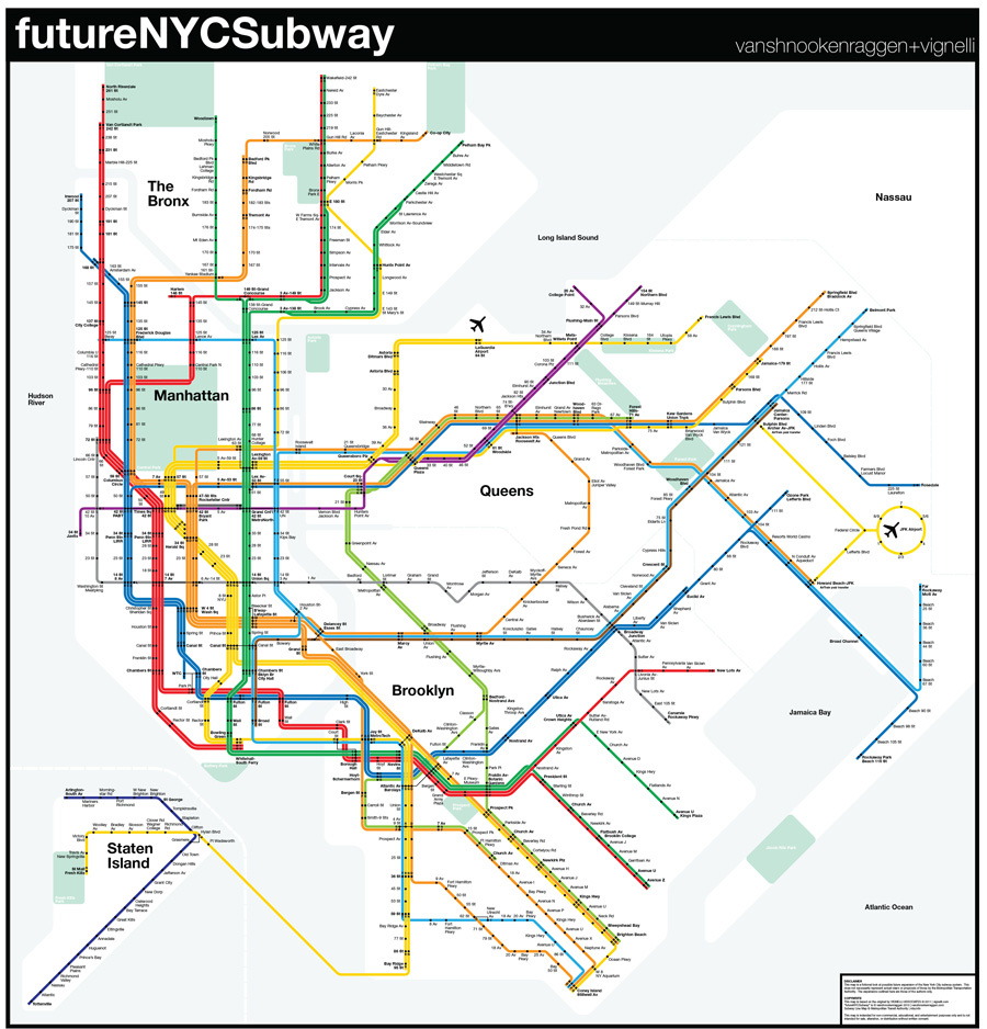
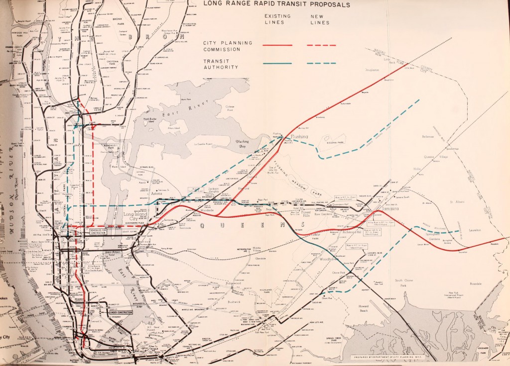
The futureNYCSubway series was never supposed to live this long. It was supposed to have been a one-off, much like my previous futureMBTA series. I would then move on to other cities. But, I didn’t. Every time I dug under the surface, I found more to talk about.
The initial “plan” was simply a collection of historical ideas with my own spin on them. Then I went wild with it. While there are now a half dozen different published versions, I have dozens more which will never see the light of day. I used these as test grounds for new ideas and new drawing techniques.
At some point I realized there were no new ideas. I decided to go back to the beginning and discover the stories behind these failed dreams. I am no longer interested in large-scale plans, full of crayon lines. Instead, I want to understand each idea on its own, usually through a miniseries of posts.
I have been asked if I stand by many of my old ideas. Some were great 100 years ago, 20 years ago, and today. Some have not aged well. I leave these posts as written history to educate and inspire the next generation of planners and historians.

WestEndExp,
1. Ok understandable but still think it was a dumb move.
2.Well then why couldn’t the B and C swap yards then?
3.Ok but the locals get there in the same amt. of time! It’s pointless!
4. Why didn’t they just create the 1 express and move the 2 to permanent local service?
Tyler:
Riders who really want this can just make a cross-platform transfer at 125 St to the (A) or (D). It’s that simple. Also, this would have the (A) running local on weekends between 145 and 168 if the (B) goes to 168.
If you detime 6 and 8 Avs the expresses would be much, much, faster. Plus, people do not care if the time savings are minimal. Also, keep in mind delays and signal problems could happen at any time.
That would be EXTREMELY HORRIBLE. You would have a severe bottleneck at 96 St with cascading delays. In other words, the (1) and (2) would have to criss-cross in front of each other. This will also make the (5) even more crushloaded since your (2) is local. A mob of passengers at 96 St would be very common. So just leave the Broadway-7 Av line as-is!
WestEndExp, fair enough. I give up arguing with that logic
Can the X train really get the title of Triboro RX?
Now the prefix tri comes from the Latin word ‘three’, and there are many that serve three boroughs, an example being the B,D,2,4, and 5 which all serve Bkyln,Manh, and The Bx. Or the A,F,R,M,J, and Z trains which serve Bkyln., Manh., and Qns. .
The X train on the other hand would mainly serve 3 boroughs: Brooklyn,Queens, and The Bronx. It would only enter Manhattan and Staten Island for one stop, St. George and 145 St-8 Av. But either way the X is serving all 5, so it would technically be the Pentaboro RX.
Subway Line for your thoughts:
A line that would start in Bay Ridge, travel up 4 Av to Barclays Ctr, then continues under Ashland Pl to Park Av and travels under the BQE until McGuiness Blvd in Greenpoint, which from there it will run under McGuiness to 21 St, then at Dimtars Blvd will curve under Dimtars Blvd to LGA, then tunnel under College Pt. Creek and curve up to College Pt. Blvd and from there it would go to The Bronx where it would tunnel under Castle Hill Av, curve up Tremont Av, and stay down Tremont Av to Schurz Av in Throgs Neck. It pretty much makes a 180 around East Bronx.
WOWZA
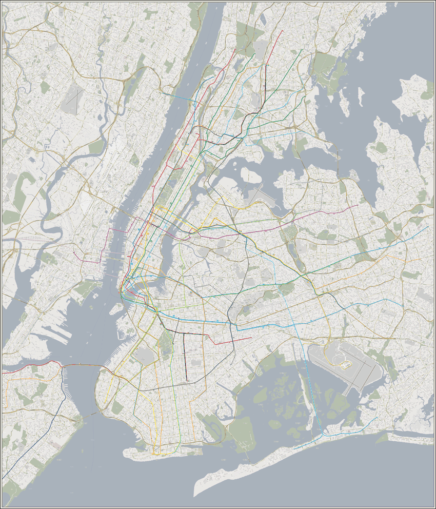
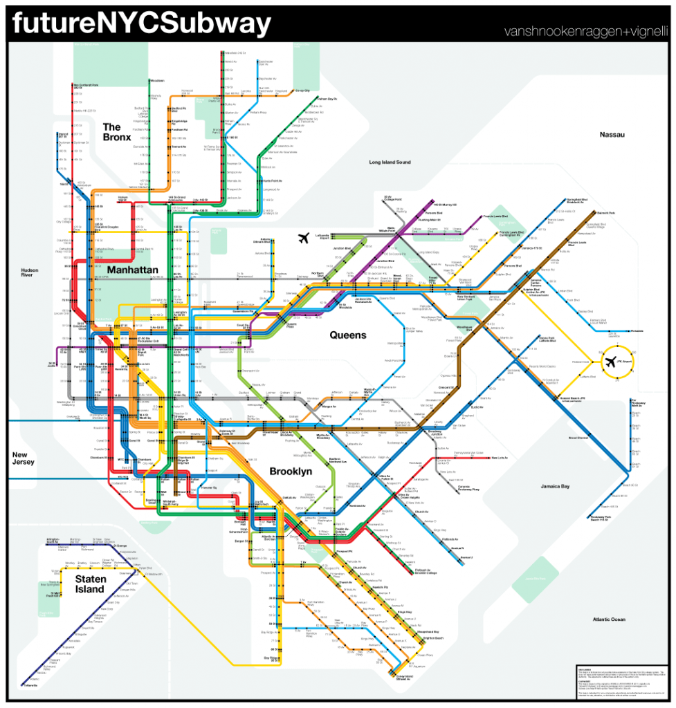
It’s been super-long, but are there any updates on a new futurenycsubway map?
No, I’m working on other maps at the moment. I am working on a regional rail plan too. But any futureNYCSubway posts will be limited to individual lines or proposals.
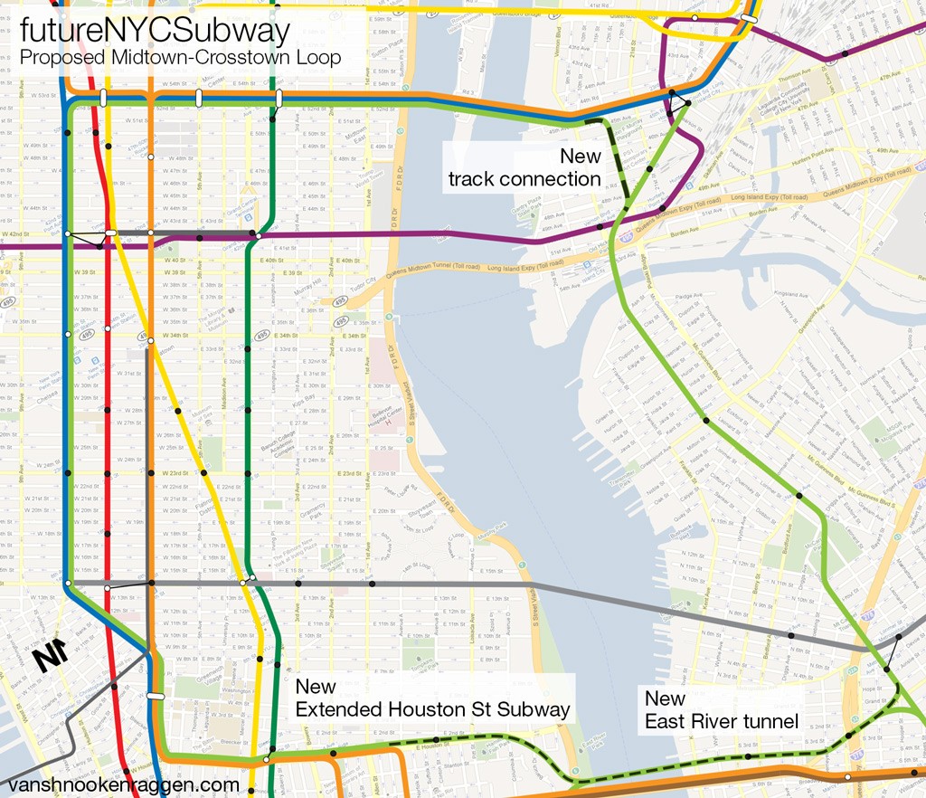
This would cost way too much if it were built. But since this is a fantasy map sorta, it’s pretty good. What I was thinking for the Manhattan-Glendale-Maspeth-Jamaica line was a second 42 st line, the 9 train, which would start at the Hudson Yards station on the 7, then go with the 7 until Hunters Point, then split up, switch to the Lower Montauk line, and run on the ROW until 121 on the J+Z, then curve down into the Rockaways which would be converted to IRT usage. Of course, there would be a transfer to the A. (To avoid congestion on the 7 because of the 9, many Manhattan-bound 9 trains would end at Greenpoint avenue, which has no relation to the G, it will be a new stop on the 9)
Good idea for the Rockaways.
I think you should make a more scaled-down version of this proposal so it could be possible in the near future, excluding 2nd Avenue in Manhattan (but only Manhattan) b/c that’s very possible and is under construction. But I think this plan, while a pipe dream of sorts, is cool and would benefit this city and NJ and Nassau. You should probably add a Lower-Manhattan to Newark line, or a Staten Island- Newark line. But either way, this is amazing! Would you provide NICE (the bus) reroutes for those Queens extensions? Because people in Nassau don’t need 179th or Main Street with your plan.
NICE Bus will still service Downtown Jamaica and Flushing because of demand. There will be new NICE Bus routes to carry people to the new Subway Stations of extended lines.
I am strongly advising that South Shore Brooklyn and Queens either has a Subway line or Light Rail line as a Crosstown link, and the same for Eastern Queens to The Bronx (as a Light Rail) to help relieve pressure on the Q44 SBS.
I also think if the (E) should be extended past Jamaica Center, it should NOT be to Southeast Queens. But rather returning to the Van Wyck Expressway to terminate at Rockaway Blvd, just to allow the Port Authority Shuttle Buses to pick up and drop off there from JFK Airport when the AIRTRAIN service is suspended.
The (Z) should be the line extended to Rosedale as there is not that much demand for Subway service in Southeast Queens (trains to arrive every 10 minutes at Peak Hours and every 15 to 20 minutes at Off Peak Hours), while the (J) is extended to Queens Village and further to Glen Oaks (relieve pressure on the Q46 and provide a direct transfer to the (F) at Springfield Blvd-Hillside Avenue).
Maybe the (7) should be left alone because like the Lefferts Blvd (A), there’s an elevator or escalator blocking the way. The Northern Blvd line should be the line that extends to Bayside (Bay Terrace), Fresh Meadows-Oakland Gardens and Whitestone.
I have an alternate history question for you even though it’s off topic to your post here. I was going to post this on the “Unbuilt Highways of New York City and Robert Moses” page but comments were closed. My question was what if Robert Moses built subways and crippled highways instead of building highways and crippling the subway system. Thanks in advance.
Well that doesn’t make any sense because there were no highways to cripple back then. Also the demand for roads was a real thing. What was needed was a balanced approach where he should have built subways along side highways. If the LIE, Van Wyck, Cross Bronx, and his bridges had had space for mass transit we’d all be much better off.
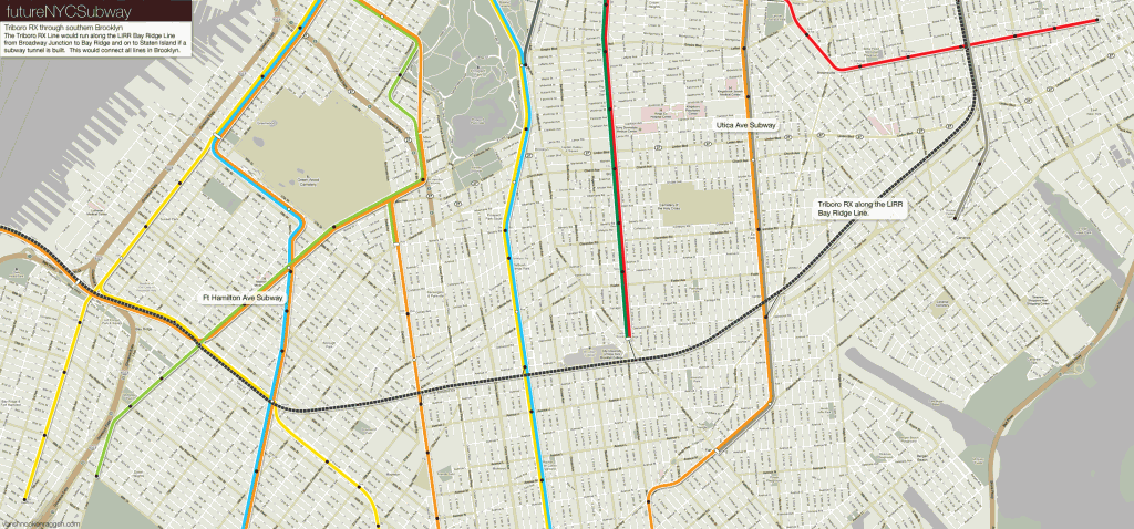
The UTICA AVENUE Subway will remain UNSUPPORTED, unless it is built into Triboro RX or the Canarisie line. I do not agree with the B46 SBS routing with its North Terminal at DeKalb Avenue, however I cannot argue against the high frequency of service the route demands.
I can agree with vanshnookenraggen on the issue, as if we were to look at the Chicago Transit Authority, you can see the Red and Blue lines are built along the Expressways (the Red along the Dan Ryan and the Blue along the Stevenson). If Robert Moses had any sense, it would be a much better idea to have the Subway lines in the middle of the LIE and Van Wyck Expressway rather than bringing noise to the Corona and Elmhurst communities with the Flushing Line.
How can I create my own. Have some ideas as well just for personal purposed of course.
Use Google Maps. They have a feature where you can draw your own maps. I use this whenever I sketch out an idea.
Just say this:
(E) – Guy R. Brewer Blvd Subway (to 137th Avenue – Rochdale Village).
(F) – Hillside Avenue Subway (to Queens Village – Springfield Blvd).
(J) – Central-Eastern Queens extension (to Glen Oaks – above LIRR ROW).
(V) – Cambria Heights line (extended from 179th Street – Jamaica via Farmers Blvd and Linden Blvd).
(Z) – Merrick Blvd Subway (to Rosedale – 243rd Street).
Are you going to post another article?
There is a new FNYCS coming. It just takes me a long time to develop the ideas.
Hey are you going to post another post onto this website? I’ve been a fan since futureNYCsubway v4 and I’d hate to see this website go…
I am! It’s way more detailed than ever before so it’s taking much longer. But I promise I am working on new content.
You’re making something new? Nice- will it be a short term kind of plan or will it be more long term?
What happened to the interactive map?
It looks like the website which was hosting it no longer exists so I’ve taken it down.
This Is My Description:
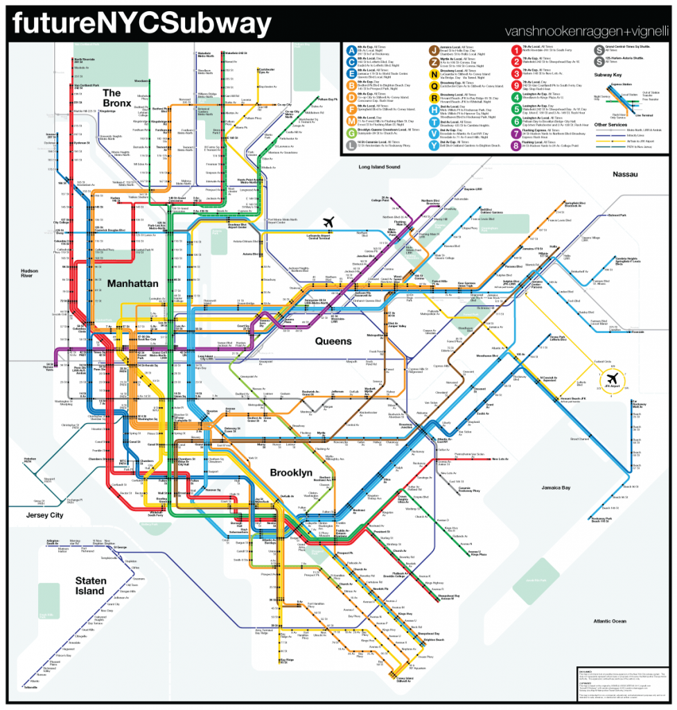
(A) 207 St – Far Rockaway (8 Av Exp, Fulton St Exp, Rockaway Lcl)
(B) Brighton Beach – Co-op City (Concourse Exp, 6 Av Exp, Brighton Local)
(C) Rockaway Park – 168 St (8 Av Lcl, Fulton St Lcl, Rockaway Lcl)
(D) Coney Island-Stillwell Av – White Plains Rd (6 Av Exp, Concourse Lcl, West End Exp)
(E) Jamaica Center – Coney Island-Stillwell Av (Culver Exp, 8 Av Lcl, Queens Blvd Exp)
(F) Francis Lewis Blvd – Coney Island-Stillwell Av (Culver Lcl, 6 Av Lcl, Queens Blvd Lcl
(G) Astoria Park – Church Av (Astoria Exp, Crosstown Lcl, Culver Lcl)
(H) Dyre Av – Bay Pkwy (2 Av Lcl, Bronx Lcl, West End Lcl)
(J) Hylan Blvd – Jamaica Center (Nassau St Lcl, 4 Av Lcl, Staten Island Lcl)
(K) 175 St – Kings Hwy (8 Av Lcl, 4 Av Exp, Sea Beach Lcl)
(L) 72 St – Rockaway Pkwy (Canarsie Lcl, 14 St Lcl, 10 Av Lcl)
I’ll Save The Rest For Normal Service.
What would be your thoughts of switching the “C†and “E†with the “F†and “M†at West 4th? The “C†would go to Coney Island which would provide Coney Island and the lower east side 8th Avenue service. The “E†would go to Middle village. To go to 6th Avenue you would just do a cross platform transfer at Broadway Lafayette. The “M†would go to World Trade Center and the “F†would go to Euclid Avenue. And just cross the platform at canal st to transfer. The pluses of this would be that it wouldn’t affect any service because of the way that the crossovers south of west 4th are positioned. Also, would it be possible to send the Fulton st local to lefferts blvd and express only to Far Rockaway Mott Avenue?
It’s certainly possible but it would have to provide some sort of better service to these areas. I’m not sure it would really change anything so it probably isn’t needed.
2 Av Subway Provision:
(T) Fordham Plaza – Broadway Junction (via 3 Av Lcl and Fulton Express) “2 Av Lcl”
(V) LGA Airport – Lefferts Blvd (via Astoria, Fulton Lcl) “2 Av Lcl”
(W) Fredrick Douglas Blvd – Church Av (via Culver) “2 Av Exp
enjoy!
I’ll Say This:
(1) Valentine Ln-Yonkers – South Ferry (7 Av/Broadway Lcl)
(2) Voorhies Av – Wakfield-241 St (7 Av Exp, Eastern Pkwy/Bronx Lcl)
(3) Sedgwick Av – New Lots Av (7 Av Exp, New Lots Lcl)
(4) New Lots Av – Woodlawn (Lex Av/Eastern Pkwy Exp) (replaces Livonia Av Subway)
(5) Voorhies Av – Eastchester-Dyre (Lex Av/Eastern Pkwy Exp)
(6) New Lots Av – Co-op City-Bay Plaza (Lex Av/Pelham Lcl/Exp, Eastern Pkwy/New Lots Exp)
(7) Hoboken, NJ – Great Neck LIRR (Flushing Lcl/Exp)
(8) Getty Sq – West End Av-72 St (10 Av/Westchester Lcl)
(9) Perth Amboy, NJ – E 180 St (7 Av Lcl, Bronx Lcl, Staten Island/Hylan Blvd Lcl)
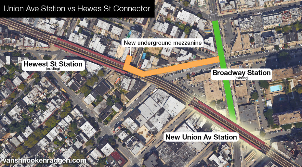
I am wondering if there is any way to salvage parts of the LIRR Bushwick line and convert it to a subway.
I’ve looked into this. The line one track in places and snakes through many buildings. There are a few grade crossings too. It probably wouldn’t be worth the hassle to reuse it. If that corridor ever needed another subway using Flushing Ave would be better.
(A) 207 St – Far Rockaway (8 Av Exp, Fulton St Exp, Rockaway Lcl)
(B) Brighton Beach – Co-op City (Concourse Exp, 6 Av Exp, Brighton Local)
(C) Rockaway Park – 168 St (8 Av Lcl, Fulton St Lcl, Rockaway Lcl)
(D) Coney Island-Stillwell Av – White Plains Rd (6 Av Exp, Concourse Lcl, West End Exp)
(E) Jamaica Center – Coney Island-Stillwell Av (Culver Exp, 8 Av Lcl, Queens Blvd Exp)
(F) Francis Lewis Blvd – Coney Island-Stillwell Av (Culver Lcl, 6 Av Lcl, Queens Blvd Lcl
(G) Astoria Park – Church Av (Astoria Exp, Crosstown Lcl, Culver Lcl)
(H) Dyre Av – Bay Pkwy (2 Av Lcl, Bronx Lcl, West End Lcl)
(J) Hylan Blvd – Jamaica Center (Nassau St Lcl, 4 Av Lcl, Staten Island Lcl)
(K) 175 St – Kings Hwy (8 Av Lcl, 4 Av Exp, Sea Beach Lcl)
(L) 72 St – Rockaway Pkwy (Canarsie Lcl, 14 St Lcl, 10 Av Lcl)
I’ll Save The Rest For Normal Service.
My response WestEndLcl?
With exception to the (A), many of these lines would be “TOO LONG”.
If there is any extension of the (F) East of Jamaica, that line will have to split with a new letter assigned to the Manhattan to Coney Island segment — I would have the (G) extended to Coney Island. Also, if you want to extend the (F) East of Jamaica to say, Springfield Blvd in Queens Village, you will have to do the same with the (J) having it run parallel via Jamaica Avenue, turn North to connect with the (F) and extend East to Glen Oaks (mainly to satisfy the LIJ bound commuters). The (Z) will have to split from the (J) at Jamaica as a Merrick Blvd line to Springfield Blvd in Laurelton.
I see no extension of the (E) because that is the “WORK-HORSE” line between Jamaica and Manhattan. Other than 40 Projects, Baisley Park Houses and Rochdale, there’s nothing more you can really do with that line because Southeast Queens is low density and will not demand high levels of Subway service.
I’ll Say This:
(1) Valentine Ln-Yonkers – South Ferry (7 Av/Broadway Lcl)
(2) Voorhies Av – Wakfield-241 St (7 Av Exp, Eastern Pkwy/Bronx Lcl)
(3) Sedgwick Av – New Lots Av (7 Av Exp, New Lots Lcl)
(4) New Lots Av – Woodlawn (Lex Av/Eastern Pkwy Exp) (replaces Livonia Av Subway)
(5) Voorhies Av – Eastchester-Dyre (Lex Av/Eastern Pkwy Exp)
(6) New Lots Av – Co-op City-Bay Plaza (Lex Av/Pelham Lcl/Exp, Eastern Pkwy/New Lots Exp)
(7) Hoboken, NJ – Great Neck LIRR (Flushing Lcl/Exp)
(8) Getty Sq – West End Av-72 St (10 Av/Westchester Lcl)
(9) Perth Amboy, NJ – E 180 St (7 Av Lcl, Bronx Lcl, Staten Island/Hylan Blvd Lcl)
My response to Paris Abney Jr?
No need to extend the Subway lines past the City Line. We have MetroNorth Railroad and LIRR for that.
Any extension of the (2) will require the line to split. The run time between Wakefield and Flatbush is 1 hour and 40 minutes. The (5) shaves off 20 minutes due to its Lexington Avenue operation.
We have an uphill battle to have any Subway line extended to Co Op City, but it is more likely going to be Triboro RX than any of the current lines.
I know this is FANTASY maps, but if there’s any plans for future Subway line extensions, you may want to consider Bronx to Jamaica parallel to the Q44 SBS. It won’t replace the Q44 SBS because of certain neighborhood operations in The Bronx with transfers at Parkchester to (6) and Triboro RX, and at Pelham Parkway to (2) and (5) before establishing a Fordham Road/Kingsbridge Road Subway line. This most likely will follow the Bx9, Bx12 and Bx22 routes in Central Bronx, the Bx39 route along White Plains Road, and in Queens the Q25/Q34 route (perhaps relabeled QT16) to Jamaica Center.
I found a fix for the dynamic map, simply paste the link into web.archive.org, there’s a save from 2018 and it worked on mobile.