
Early this morning the MTA quietly published the initial outline of their new 20-Year Needs Assessment (YNA) study which is now underway and will be finished in October 2023. The MTA claims that they put together a list of needs and wants every five years, but this is the first time that I’ve seen it been open for public discussion.
Most of the MTA 5-Year Capital Plans are dedicated to state-of-good-repair work. The 20-YNA adds to this a list of expansion projects which aims to address changing travel and development patterns. Given that the MTA is facing a once in a lifetime shift in how we live and work in cities due to the rise in working from home, now is the perfect time to start thinking about what it will take to bring enough new riders to the system to keep things, uh, sustainable.
The MTA is evaluating projects based on how they meet the MTA’s “Investment Principles”
- Expanding network reach: Connecting underserved or new communities to education and employment opportunities
- Serving changing travel patterns: Serving intra-borough and inter-borough travel markets and enabling new business districts
- Supporting local land use: Connecting people and places, creating new employment opportunities, and encouraging new development
- Adding capacity: Satisfying current and future demand or relieve overcrowding
- Enhancing network resiliency: Increasing travel options and redundancy in the transit network
Initial List

To get the ball rolling, the MTA has included a decent sized list of potential projects which may be included. From my initial read through, it seems that they just went by the planning department and dusted off whatever they could find. I’ve always bemoaned the lack of any real transportation planning (or urban planning for that matter) in NYC and this list shows a true lack of creative thinking on the part of the MTA. The disconnect between land use and transportation in planning means that the city and state only work together when you have both sides wanting to work together.
You can read the entire list here, but I will cherry-pick a few projects that I think are worth mentioning. I am going to focus mostly on the subway plans since that’s more of my expertise. After that, I’ll have my own list of projects that I think the MTA needs to consider. There are a few other ideas that I have outlined on this site before that I won’t include, some that I don’t think are needed in the next 20 years, and others that fall outside the purview of this exercise.
Subway Projects
10th Ave station of the Flushing Line
This is a project which shouldn’t have been on this list because it should have been included in the original 7 train extension to Hudson Yards. The entire project was never a priority for the MTA and only built it at the behest of Mayor Michael Bloomberg to support the Hudson Yards development. A station at 10th Ave was dropped due to rising costs, but a level section of track was built so that a station could be added later.
Much of the development at the heart of Hudson Yards is commercial. But the development going north along the new Hudson Blvd and 10th Ave is purely residential. Even a decade ago, 42nd St was being lined with massive high-rise apartment buildings. Not to mention the existing community of Hell’s Kitchen which has been gentrifying for years.
An infill station would be greatly used, possibly more than the 34th St-Hudson Yards stop, and could be financed with the help of private developers building out the far west side.
Extension of the New Lots Av 3 line
This has always been a low-hanging fruit project, yet so often with the MTA low-hanging fruit are the first projects to get cut when funding gets tight. The IRT New Lots Line was built with the intention of extending the line further into Brooklyn or Queens. As East NY and New Lots were never “hot” areas of the city, the need to extend the line never materialized.
In the late 1960s and early 1970s the city set its eyes on the vast swaths of undeveloped land in East NY along the coast of Jamaica Bay. The city wanted to develop the area with thousands of new apartments, a shopping center, and new industry. The initial plan, included in the MTA’s 1968 Plan for Action, involved the 3 train being extended through the Livonia Yard to a new terminal at Flatlands Ave to support the new development.
Planners shifted their thinking as the scope of the proposed new development got larger. Instead of the 3 train, planners called for the BMT Canarsie Line, L train, to be buried from Broadway Junction to New Lots. A massive new expressway, the Cross-Brooklyn Expressway, was planned to run along the LIRR Bay Ridge Line from the Verrazzano Bridge to JFK Airport. Planners called for building two branches of the L train down the median of this expressway, one going to Brooklyn College and the other serving Spring Creek.
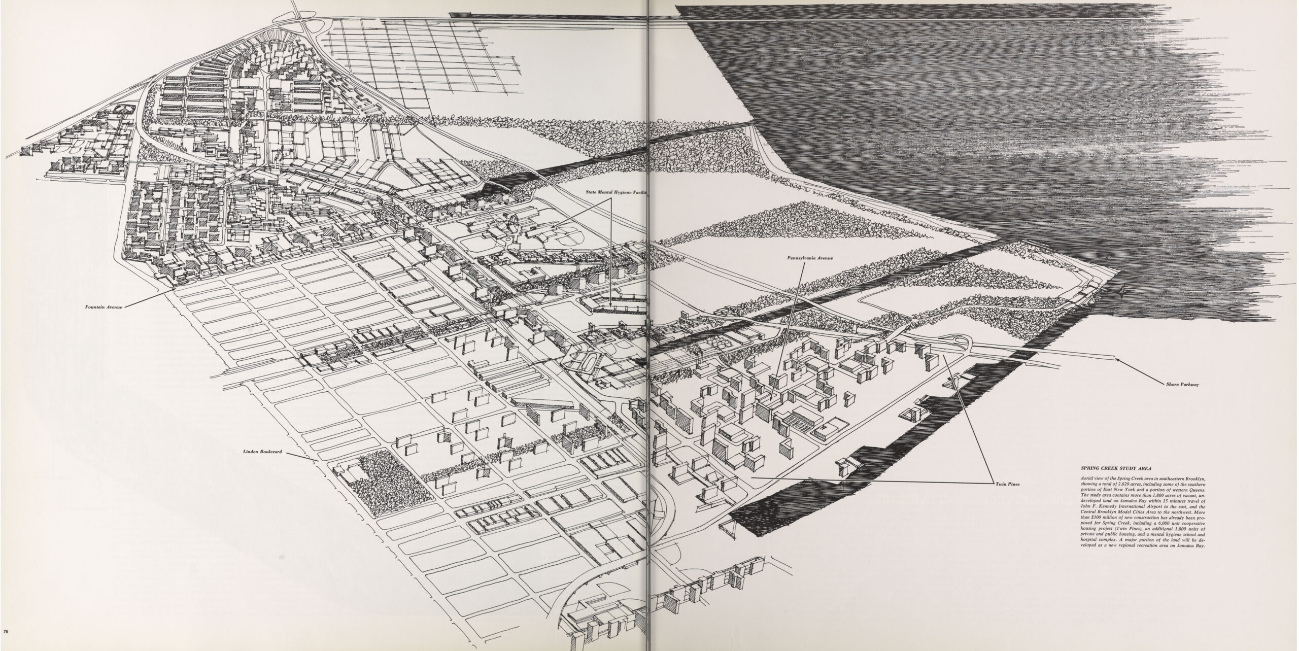
In the 1970s, federal funds to cities for highways and housing dried up. This, combined with the fiscal crisis of the city and the massive underselling of construction costs by the MTA, meant that all of these grand plans were shelved. East NY slowly developed over the next 30 years with the opening of Starrett City and the Gateway Center. But the lack of a transit connection meant that the character of the area was more suburban and car-dependent.
Extending the 3 train a few blocks should have been done well before this area of the city developed. Now that most of the area is built out, it will be harder to pay for such an extension through value capture. A three-block elevated train down an industrial side street should be an affordable proposition, but since the line would be well east of Starrett City, the new ridership potential is a lot lower. While I support this plan, I can see it being cut early on.
Rockaway Beach Branch/QueensLink
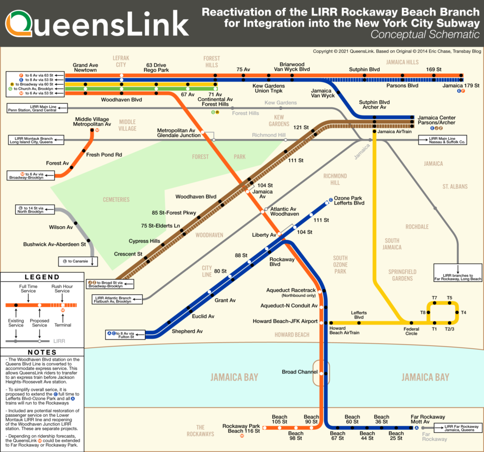
Obviously, I’m going to be biased towards a project that I’ve worked on for the last 5 years. I was happy to see this on the list, but I am worried that the MTA will take its own flawed feasibility study and cost estimate at face value. QueensLink showed that the MTA intentionally sandbagged the cost of the project in its 2019 study, showing that the initial $8 billion estimate had been exaggerated and that the hard costs were a more realistic $1.6 billion (with added soft costs, $3.5 billion).
The QueensLink team has spent the last year engaged in community and political outreach with representatives along the right-of-way, and we will soon be releasing a letter of support, being sent to Mayor Eric Adams and Gov. Kathy Hochul, asking that the MTA produce an unbiased Environmental Impact Statement for the project to determine the true costs and scope of extending the M train south from Queens Blvd to the Rockaways and using the land along the right-of-way for new park space.
We believe that the initial ridership projections of 47,000 daily riders (which, btw, is nothing to scoff at), is low and that creating a local, crosstown connection between northern and southern Queens would see up to 80,000 daily riders. True, many of these will be current riders that will not add to the system, but the new connection will speed up travel times so much that it will shift many drivers over to the subway. It’s a project like this which the MTA needs to focus on to build a new ridership base after COVID.
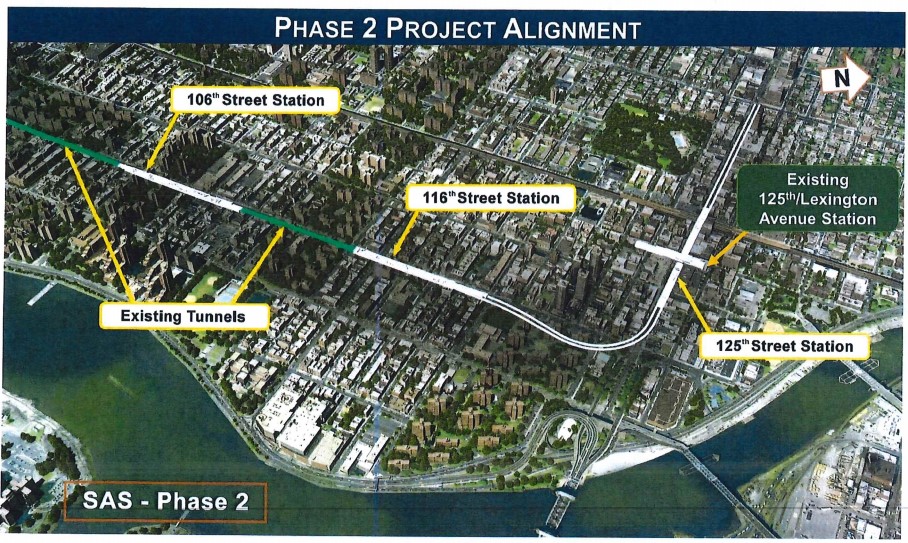
2nd Ave Subway: Phase 3 and Harlem Crosstown
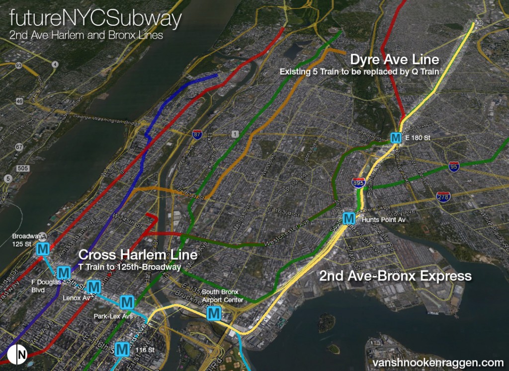
While the next phase of the 2nd Ave Subway was always going to be on this list, I am very happy that the MTA is seriously considering the cross-125th St extension. This was never part of the previous 2nd Ave plans, but once planners decided to turn the 2nd Ave subway west along 125th St, instead of going to the Bronx, the line begged to be extended.
It’s almost criminal that the second phase of the 2nd Ave subway didn’t include this extension west to begin with. But since construction of the next phase hasn’t begun, provisions or work could be included in construction which would make extending the line to West Harlem easier.

Interestingly, the MTA says it will be looking at a few different alternatives for terminal locations. West 125th St is built along a fault line, so building a tunnel through the area becomes tricky. A subway station below the 125th St 1 train station, which is elevated, would require expensive engineering to connect the two stations with stairs and elevators. With all of this in mind, planners are looking at running 2nd Ave up to 137th St under Broadway or Riverside Dr, or even possibly connecting it to the IND 8th Ave Line at 135th St.
I hope that the MTA focuses more on this part of 2nd Ave than Phase 3, which would extend the line south of 63rd St to E Houston St. While there is certainly a need for a new subway through Midtown East, the current two-track design of the subway leaves much to be desired. The loss of express tracks on 2nd Ave means that reverse branching will be forever hard-wired into the system, and will cap system capacity in the heart of the city, exactly where you want to have the most capacity.
Phase 3 of 2nd Ave MUST include 4-tracks, at least in Midtown East. 4-tracks will allow for more flexibility in service patterns and enough redundancy for when trains get delayed. A new service to Queens is needed to reduce crowding on the Lexington Ave Line. The 63rd St tunnel was built for such a service, but the reverse branching that this would create will cause, or at least perpetuate, delays with merging trains. I’ve designed a station layout which will also future-proof the subway should the MTA, in the distant future, want to add express tracks to the Bronx or a new tunnel to Queens.
Looking at the big picture of how I think commuting in NYC will change in the next 20 years, I feel that the MTA really needs to focus more on better service in the outer boroughs. 2nd Ave Phase 3, in any way they design it, is going to be the most expensive mile of subway ever built. It will have to contend with an avenue lined with skyscrapers with deep foundations, and threaded around a number of existing subway and highway tunnels. I want the MTA to make sure it designs this phase with the most amount of system flexibility and future-proofing. But I’d rather see them spend the money where they have more of an impact of reducing auto-centric land use (i.e., the suburbs).
Utica Ave and the Interborough Express
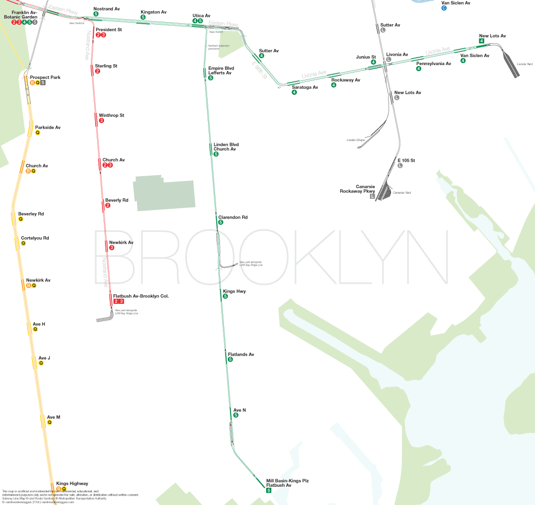
For those paying attention, the MTA had started a feasibility study about improving transit along the Utica Ave corridor in southeastern Brooklyn before the pandemic. After the delay, the MTA claimed it was working on the study again. But after Gov Andrew Cuomo resigned, Kathy Hocul began looking for a transportation project to shore up votes in NYC. The MTA had also been assigned to study the long proposed Triboro Line, adding passenger service to the circumferential LIRR Bay Bridge Line connecting Brooklyn, Queens and the Bronx. Suddenly, the MTA rushed to put out a “study” for her new line, renamed the Interborough Express (IBX).
Work on the Utica Ave study was put on the back burner. A small and dedicated group has called for the MTA to release their work, though the MTA claims it hasn’t finished the study yet. The wording on the MTA’s website suggests that they are taking a more holistic approach, looking at the character of the corridor and evaluating all possibilities.
I’ve looked at the Utica Ave Line before and after doing some extensive digging in the Brooklyn Eagle archives I’ve found how, time after time, the city or state has proposed an elevated line down Utica Ave to Flatbush Ave, only to have the local community push for a subway. When the powers-that-be changed their tune in favor of a subway, the project was used as a pawn to gain more funding, then ultimately dropped in favor of other projects. I have no doubt that history will repeat itself once again.
What worries me is that if the IBX is built, it will be used as an excuse for no longer needing the Utica Ave Line. You see, the LIRR Bay Ridge Line cuts across Utica Ave almost in the center of the north-south corridor. Utica Ave already features a decent SBS line. With heavy rail cutting through the center of the corridor, many riders will no doubt make the transfer. The ridership will justify the IBX, but also mean that spending the extra billions for a full subway might not be needed.
Utica Ave and IBX serve two different, yet equally important corridors. Utica Ave ridership might take the IBX to the nearest subway (Brooklyn College or Broadway Junction), but ultimately this adds another transfer and more time (not to mention, adding congestion at these transfer stations.) The Utica Ave subway will be more direct and quicker. Without it, large residential sections of East Flatbush and Flatlands will still be a multi-seat ride away from Manhattan.
I would imagine that in the short term, if anything is done along Utica Ave it will be improved BRT. Long term, a subway extension, in a tunnel, to around Kings Highway is the most we can hope for. South of Kings Highway the water table is higher and tunneling becomes much more expensive; possibly prohibitively. For Utica Ave to be built in any type of affordable way it must be on an elevated structure. Concrete guide ways are less intrusive and quieter than the Els we are accustomed to. I fear that yet again, there will be pushback against the plan and the can will be kicked forever down the road.
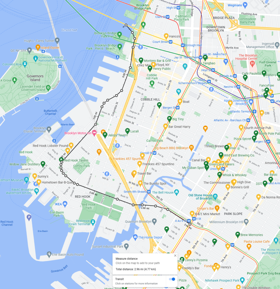
W line extension to Red Hook
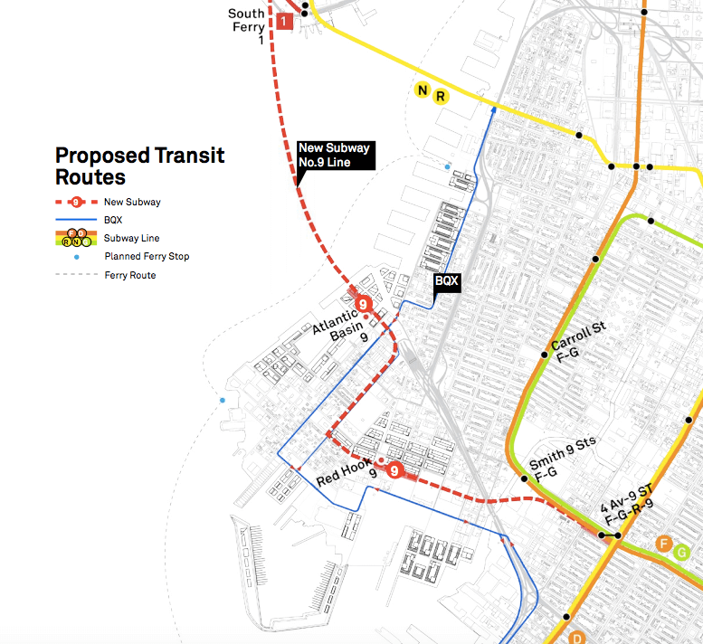
Finally, something out of left field! The plan calls for branching off the Montague Tunnel on the Brooklyn side of the East River and a new tunnel under Columbia St, Van Brunt St, Lorraine St, and a possible continuation to 4th Ave. There would be three new stations and possibly a fourth at the 4th Ave end.
Long time NYC transit fans might remember back in 2016, AECOM proposed extending the 1 train (or, in their plan, a resurrected 9 train) from South Ferry to Red Hook. The plan was less altruistic and more of a brash ploy to redevelop one of the last areas of the Brooklyn waterfront to be touched. Red Hook, despite being located almost at the heart of the metropolitan region, is cut off from the rest of the city by the BQE. Developers have been salivating at the idea of redeveloping Red Hook (i.e. removing the poor, minority housing project dwellers) for a generation.
The 1 train extension, besides being fucking stupid, probably wasn’t feasible. It would have required a brand new (and needlessly expensive) tunnel with a complex connection to the existing IRT 7th Ave Line. In Red Hook, the line would have made a series of twists and turns that would have kept operating speeds rather slow. The only transfer would have been at 4th Ave and 9th St, meaning that many riders would have had to double back to get to downtown Brooklyn.
The W train alternative chops off the new river tunnel in favor of using an existing, albeit under utilized tunnel. Today W trains terminate at Whitehall St but continue into Brooklyn once their runs are done, sans passengers, to reach the Coney Island Yards. Using the W would make far more sense since it could be connected to the BMT 4th Ave Line south of 9th St or the IND Culver Line at 7th Ave.
But that’s more of a solution looking for a problem. A Red Hook subway is still a developer’s wet dream and would 1) never make financial sense 2) would hurt the rest of the system and 3) subsidize development in the absolute last place we should, flood prone waterfront neighborhoods.
Ask anyone who rides the R train in Brooklyn and they will tell you what a nightmare that service is. W trains, at the very least, should be extended along the existing 4th Ave Line. Trains could short turn at 9th Ave on the West End Line, go to Coney Island on the Sea Beach Line, or even bring more service to Bay Ridge.
Building a branch off of the Montague Tunnel at this point would create a new choke point and limit service along the rest of the 4th Ave Line. But that doesn’t mean there isn’t some value in the idea. I’ll cover this later.
Regional and Commuter Rail
Given my lack of familiarity with many of the other projects on this list, I won’t do too much of a deep dive. In general, electrification of the far-flung branches of the commuter rail system will be better than using dirty diesel trains. It will also allow them to run directly into Penn Station or Grand Central.
What I don’t see is any mention of regional rail through running at Penn Station. I’ve always stated that a project of that scope would require a political compromise larger than any planner’s job qualifications. But it doesn’t mean that a transportation planner at the MTA couldn’t make the economic case for regional growth that such a realignment would bring.
Metro North Harlem and Hudson Line Improvements
When I outlined my ideas for transit needs in the Bronx, I showed that the two major unserved north-south corridors just so happened to have commuter rail lines running down the center of them. The Northeast Corridor will soon see new stations and Metro North service into Penn Station, known as Penn Access.
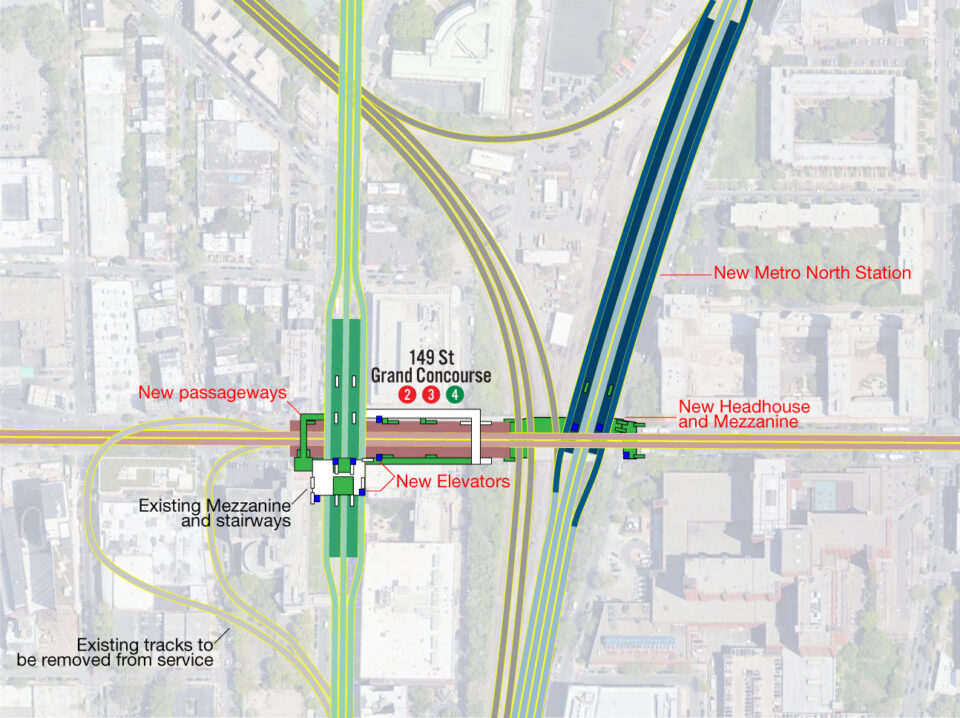
The Harlem Line is where the most new investment should be made. The Harlem Line once had a number of stations in the Bronx which were all closed long ago. Adding these local stops back would make up for the loss of the 3rd Ave El back in the 1970s. The Harlem Line would allow Bronx riders faster access to Midtown East and serve many of the reverse peak commutes into Westchester and Connecticut. With a lower city fare, similar to the Atlantic Ticket on the LIRR, it’s possible that the Harlem Line infill stations (especially one at 149th St) could reduce congestion on the 4/5 trains enough to make up for the loss of the 2nd Ave Subway in the Bronx.
Early studies about Penn Access also looked at the possibility of using the Hudson Line with service down the west side of Manhattan into Penn Station via the Empire Connection, a single track built to connect Penn Station (built by the Pennsylvania RR) to the west side tracks of the NY Central RR. Presently a few Amtrak trips a day use the line, serving upstate, Vermont, Montreal, and Chicago.
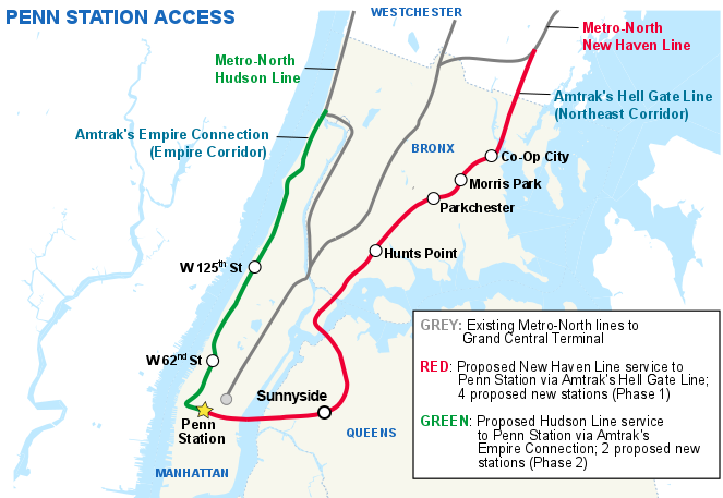
This single track means that frequent levels of service are not possible. Depending on the terminal operations at Penn, about 4 trains an hour max could run through the tunnel. NYS is looking to increase Amtrak service to upstate and this capacity would be taken over by such service. Adding infill stations along the west side of Manhattan would make sense for Metro North, but not for Amtrak. A new tunnel connecting the Empire Line to Penn Station, under Hudson Yards, may well be possible and not too complex. But that would require study.
LIRR Elmhurst Station
I’m glad someone remembered this one. The idea was last floated by Representative Joe Crowley before he was unseated by star Congresswoman AOC. Adding an infill station on the LIRR Port Washington Branch would be one of the cheapest improvements to the system. A new station was built on the Main Line to serve the new UBS Arena at Belmont. A new station at Elmhurst, with access to the IND Queens Blvd Line, would be far more useful.
What I wish was added to this was mention of better service on the LIRR Port Washington Line. In my previous post about extending the 7 into Flushing, the most important short term solution would be to turn the Port Washington from a traditional commuter rail service into a frequent and all day regional rail service. This, combined with subway-level fares, would be able to greatly reduce crowding on the 7 train.
Bus Rapid Transit
Staten Island
BRT service covering Staten Island seems like a no-brainer. There is space on the roads and highways, and possibly even on the abandoned SIR North Shore Branch. I covered why restoring rail service on this branch isn’t going to happen, so if the ROW could be used for transit in some way that’d be great.
None of these ideas are all that new, nor all that expensive. What it’s going to take is for any Staten Island politician to step up and demand it, rather than demanding to separate the island from the city. Until there is a will, there won’t be a way.
Myrtle Ave Bus Lane
Someone was digging deep on this one. When the BRT built the Myrtle Ave Line, they extended the elevated track along a former steam train (dummy train, as it was known) line that once served the cemeteries in central Queens. The ROW was kept and used for streetcars after the subway was built. But when the streetcars were replaced by buses, the new bus lines were routed along city streets, not the ROW.
The ROW in question is rather short, only running a half mile from Onderdonk Ave and Palmetto St to Fresh Pond Rd between Putnam and 67th Aves. Having once lived right by here, I would walk by and wonder if the ROW was even wide enough for two buses to pass one another. It would also bring loud buses directly into the backyards of many of the homes along the ROW. Yes, there is an elevated subway train rumbling above head. But at least that’s electric; the buses would bring in exhaust (until they are all converted to batteries). Nonetheless, I’m curious to see what the experts think.
Recommendations
I’ve been studying the NYC Subway since I first moved to NYC 17 years ago(!) In this time I’ve come up with a lot of crazy ideas for expanding the system. But I am always trying to distill them down into ever more realistic proposals. I chose to help create the QueensLink plan because I truly think that it would be affordable to build and have a city-wide benefit. While it’s been a long time since I’ve published a full futureNYC Subway plan, I have been tinkering with ideas for improving the network. Here are a few which I have not covered yet:
Southeast Queens Line
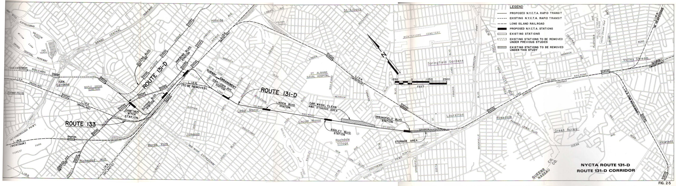
I had intended my next post to be the second part of the Southeast Queens Line proposal, but I wanted to get my feelings about the MTA’s plan out sooner than that. As I covered in the first part, the Southeast Line was part of a greater new trunk subway planned for Queens as part of the 1968 Plan for Action. Construction on the two most important parts, the 63rd St Tunnel and Archer Ave Lines, took far longer than anticipated and faced large cost overruns. Both were eventually opened 20 years after they were started.
In that time, the other components of the trunk line were cut to save money. These included the Super-express bypass tracks between Long Island City and Forest Hills, a branch along the LIE to Flushing, and the Southeast Line from Jamaica Center to Springfield Gardens along the LIRR Atlantic Line.
I will still flesh this plan out in my next post, but the long-short of it is that the Southeast Line extension of the E train from Jamaica/Archer Ave would be the most cost-effective subway expansion project the MTA could undertake today. Literally, the heavy lifting and expensive parts of this line have been built. Almost everything left to do would be above ground.
The project would involve building a third track (with space for a fourth) along the LIRR Montauk Line from about 172nd St to N Conduit Ave. The third track would allow all Far Rockaway and Long Beach Line trains to be rerouted along the Montauk Line. The three tracks would allow for two to be used for peak direction service. The existing St. Albans and Rosedale stations would be converted to serve “local” riders with the “express” (Babylon) trains bypassing. Three tracks are enough for current and future service, both peak and reverse peak. The ROW would be built so that a future fourth track could be added at a later time.
Once this is done, the Atlantic Line between Tuskegee Airmen Way and Springfield Blvd would be converted from a LIRR line to a NYCT line; the tracks would remain the same, but a new power system would be installed for the different voltage subway cars use from LIRR cars. New stations would be added at 108th Ave, Linden Blvd, Baisley Blvd, and Springfield Blvd. A new storage yard would be built along the existing ROW south of Springfield Blvd and a small maintenance facility would be built alongside the ROW between Baisley and Farmers Blvd.
Few, if any private homes would need to be taken for this (the alternative of building new tracks alongside of the LIRR Atlantic Line would require taking a number of homes.) The extension of the E train along the line would directly serve the Merrick Blvd corridor, home to heavily used bus and private jitney lines. While not directly serving JFK Airport, it would get airport workers closer, quicker.
The entire corridor has existing ridership potential, but could support large developments that would help finance the project. The area around York College, south of the LIRR Main Line, remains largely undeveloped. Rochdale Village has a number of large parking lots and commercial lots that could support more development, and there are large parking lots and low density commercial developments along Merrick and Springfield Blvds that could be redeveloped as TOD communities.
When the Southeast Line was first proposed, it was done so with the addition of the Super-express bypass which would have added express service past Forest Hills. Since the 63rd St Tunnel was connected to the Queens Blvd Line, the additional capacity has not been used to its full potential. The MTA has spent the last decade installing new CBTC signals along the Queens Blvd Line to increase capacity. This means that the Super-express bypass isn’t as crucial to the operations of the Southeast Line as it once was.
In fact, the new signals are limited by the current subway tunnels. The Archer Ave Lines were never designed to be terminals; the switch location in the tunnels limits how many trains can turn there. Building the Southeast Line would mean that 50% more E trains could run through Jamaica Center than is possible today. This is the main benefit for such an extension over, say, regional rail.
In terms of cost, the projected cost of the Southeast Line in 1978, adjusted for inflation, was about $580 million. Given that the early costs estimates for the Archer Ave Line and 63rd St Tunnel were blown out of the water, my guess is that today the project would be between $1 and $2 billion. Considering the direct effect of reducing the need to drive in an auto-dependent suburb, and the development potential, I would argue that this should be high on the list for 20-year projects.
BMT Eastern Division Platform Extensions
The BMT Eastern Division is the L, J/Z and M trains. Over the last 20 years, no line has seen the growth in ridership that the L train has. Even today, ridership on the L is strong with gentrification marching ever deeper into northern Brooklyn. When the MTA rebuilt the Canarsie Tubes after Super storm Sandy, they added two new power substations to allow for more trains to run on the L. But the line is reaching its capacity.
Something that most riders would never realize is that the L train, along with the J/Z and M, runs with shorter trains than the rest of the system. The B Division (lettered lines) almost always run with 10-car trains (the exceptions being the C with 8-cars and G with 4 or 5-cars). This means that, should the Eastern Division lines have their platforms extended, they could see an increase in overall capacity of 20% for a fraction of the cost of building a brand-new subway line through northern Brooklyn.
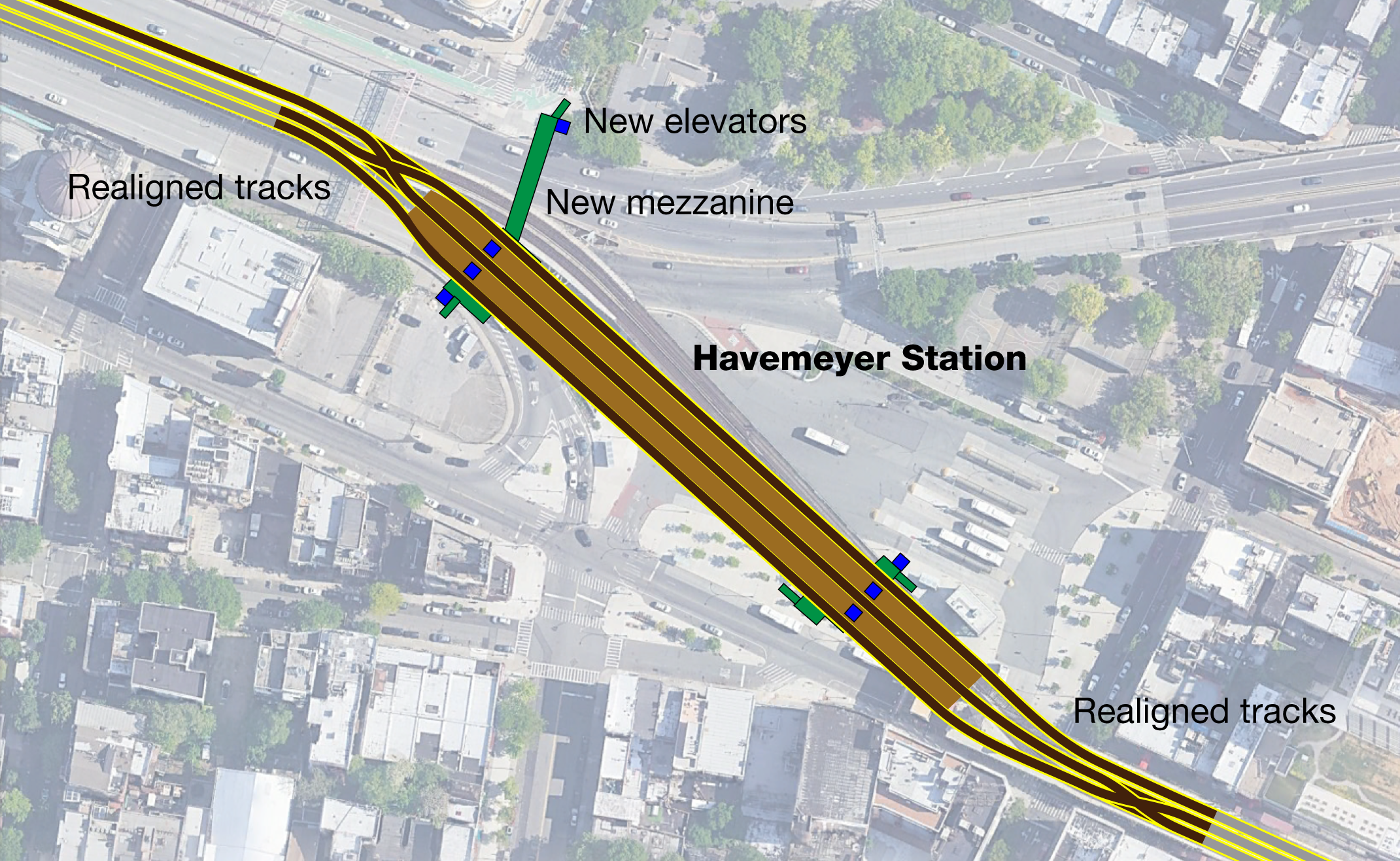
There are a number of issues that arise with this plan. First, most of the L train stations are underground and would require extensive digging, disrupting many city blocks. One benefit to this is that the new extensions would be a perfect time to add elevators to each station. J/M/Z stations are almost all above ground, but the large express stations with twin-island platforms would require rebuilding of the elevated structures to support them. Again, a good time to add some elevators.
The most difficult problem will be where to keep these longer trains. The existing yards in East NY, Fresh Pond, and Canarsie are all hemmed in and do not have the space for easy track extensions. In the case of East NY and Fresh Pond, the existing bus facilities adjacent to the yards will have to be either moved to altered to allow for the extra space. For the L train, private land may need to be taken for longer tracks, or the unpowered Linden Yard, used for materials, could be repurposed for subway cars.
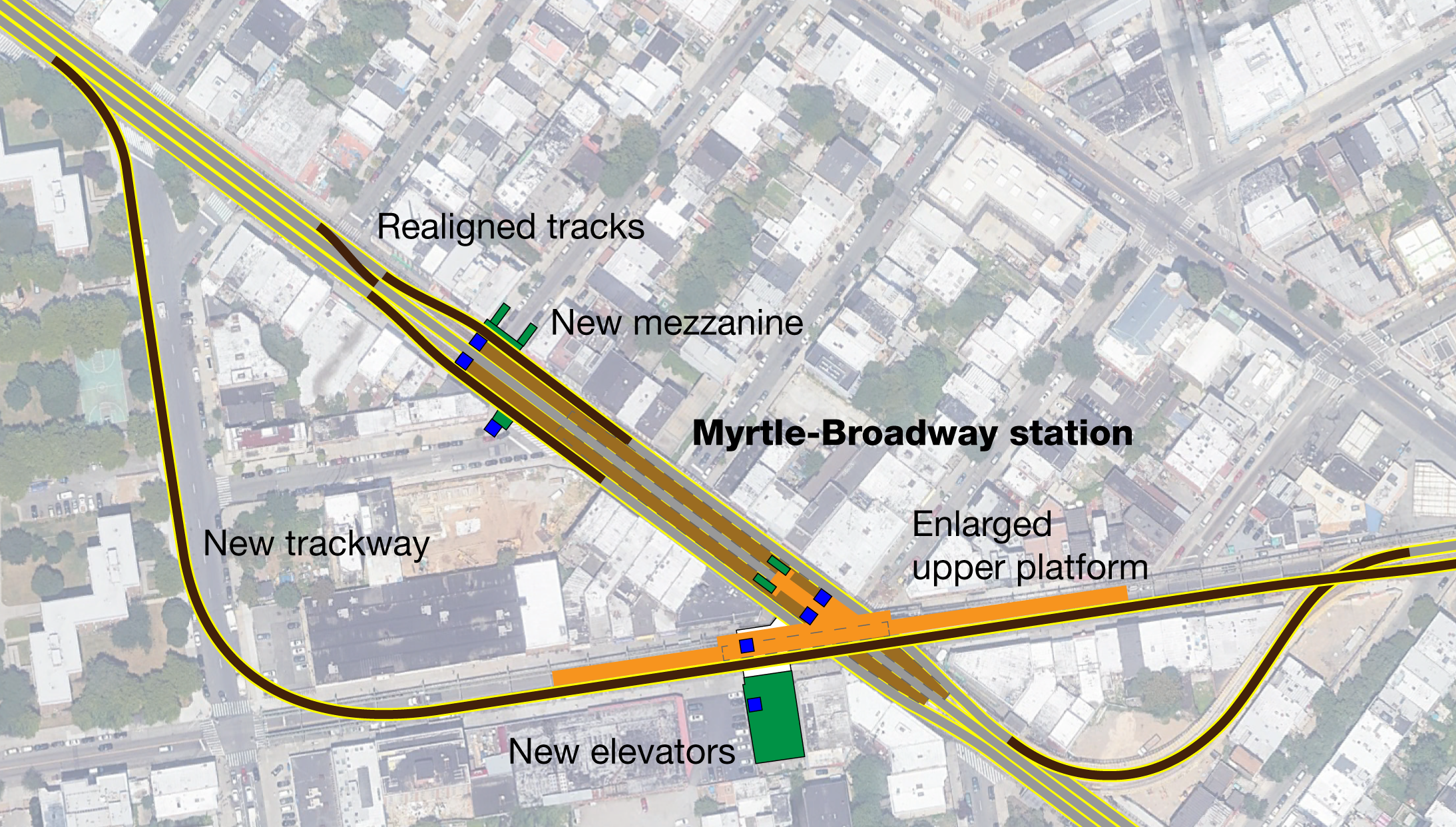
Other enhancements should be considered here, such as consolidation of stations. The Marcy Av, Hewes St, and Lorimer St stations should be eliminated and a new station at Havemeyer St and Union Av built that would facilitate better transfers and operations (and faster trips). The Myrtle-Broadway junction should be rebuilt so that trains don’t have to pass directly in front of one another. This will allow for additional capacity increases.
It’s worth looking into the full costs of the proposal. As I said, adding 20% capacity for a fraction of the cost of a new line is a no-brainer. A system-wide benefit is that the M train would be able to add more capacity on Queens Blvd, should they need to be used for express service.
R train connection to the IND Fulton Line
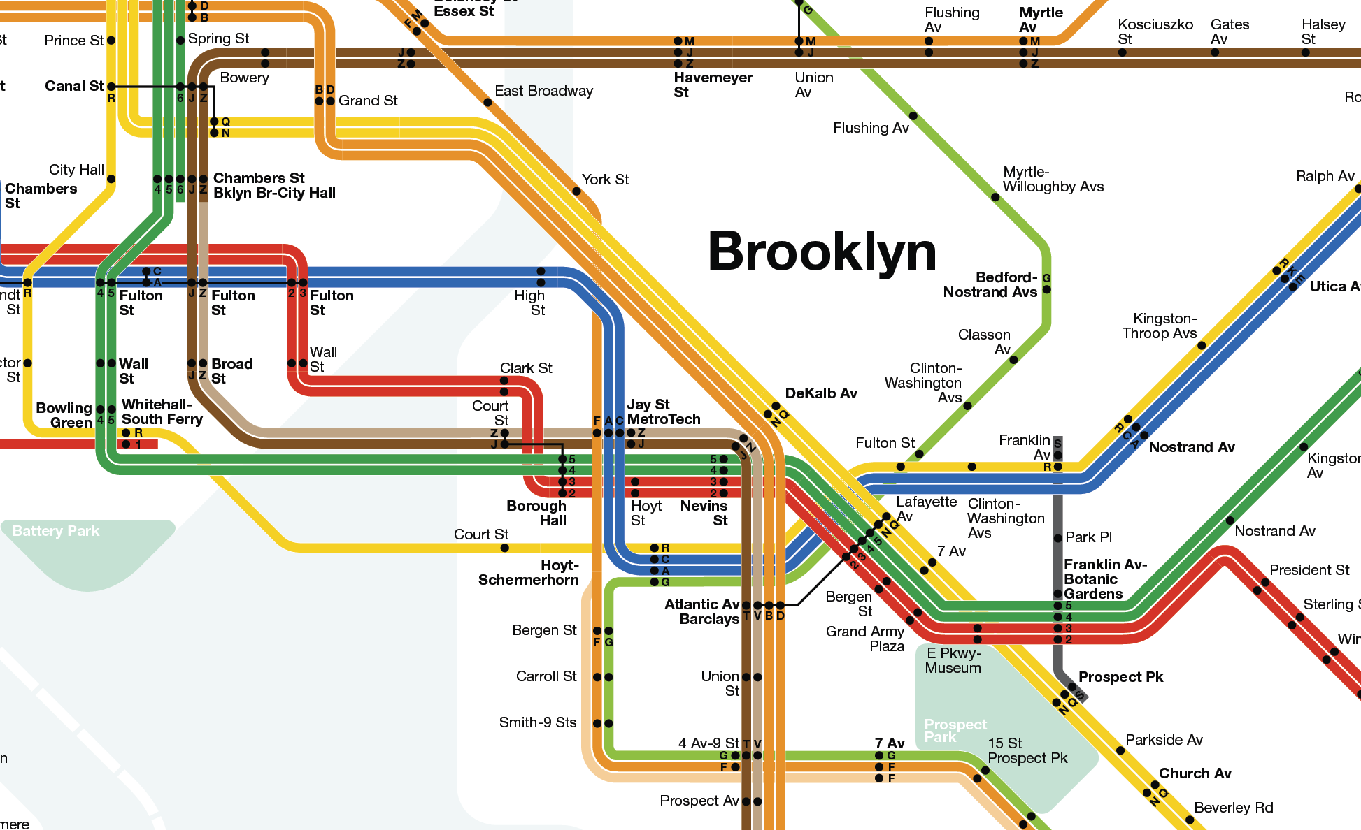
While the W extension to Red Hook might be a terrible, almost evil idea, a new tunnel into Brooklyn might not be. You see, the IND Fulton St Line was built with 4-tracks, but two of these tracks dead end in downtown Brooklyn. Because through service was planned (as part of a future 2nd Ave Subway) but never built, existing local and express service (A/C) must use the 2-track Cranberry St Tunnels. This means that overall capacity on the Fulton Line is capped at 50%. The MTA is planning on addressing this by installing CBTC signals in the next few years, but due to interlining with other lines, the A/C will still be limited.
This creates a chicken-or-egg scenario where the Fulton Line will see increasing ridership as development marches eastward down the Fulton-Atlantic corridor, but long headways will mean that many potential riders will always choose other means. This is worse for riders coming from southern Queens as the A will still have to branch two or three times, increasing headways to 20 min or more.
Literally, the only way to address this is by adding a new tunnel. Subway planners proposed connecting the 2nd Ave Subway to Fulton St in the 1930s, but given how far off that proposition still remains, something needs be done before that. The Montague Tunnel, which the R currently uses, was built with a flying junction to allow trains from the Broad St-Nassau St subway (J/Z) to continue on into southern Brooklyn. The last time this was used for revenue service was before 2010 when M trains continued along the West End Line.
Additionally, the Montague Tunnel was built with provisions for a connection to an unbuilt line. At the time when the 4th Ave Line was being built, branches were planned for the line which were never built. One such branch was from Whitehall St station to Atlantic-Pacific St that would have bypassed the central shopping district in downtown Brooklyn. Provisions for this connection remain just south of the Whitehall station. This is where a new tunnel would start.
The new tunnel would connect Whitehall to Court St, home of the NY Transit Museum. It might be possible to bypass the museum since the station itself would not see huge ridership. In any event, the Broadway local trains would then become the Fulton St local trains. R and W trains would run to Euclid Ave while A/C trains would both run express to Ozone Park and the Rockaways. This would double capacity and service through central Brooklyn and southern Queens.
The J train would then take over as the 4th Ave Local. At first glance this may seem as a reduction in service, since the J does not travel to Midtown. But any south Brooklyn rider going past Canal St is already going to transfer to the express B/D or N/Q (or 2/3/4/5). The levels of service would therefore be well-balanced.
Another benefit to this arrangement is that Broadway trains can now be deinterlined, meaning that locals and express trains would no longer have to swap tracks at Times Sq, which causes delays. Astoria trains would have access to the Pitkin Yard (and track connections would still allow them access to Coney Island.) While there are cheaper ways to do this today, it is definitely an added benefit.
A new East River tunnel probably isn’t needed for the next 20 years. But I wanted to provide a more substantive alternative to the cursed Red Hook plan.
Conclusion
There are about as many different ideas for what the MTA could do to expand the system as there are New Yorkers. What they need to focus on for the next 20 years is shifting the system away from the Manhattan-centric, hub and spoke system to one which covers the vast metropolis with a web of good service. There are many ways to do this, many more than what I touched on here. But using existing infrastructure, like the QueensLink, to enhance the network means that we can get far more for our money.
The MTA will have to find ways to pay for all this. I think that value capture is the way to go for many of these ideas. The CTA in Chicago has used value capture to pay for the total rebuilding of the Red/Brown/Purple Lines on the north side of the city. A similar scheme could be used for larger-scoped projects like expanding the platforms on the Eastern Division. Other state-of-good-repair projects could be included so that when all is said and done, large sections of the subway are going to be set up for better service for the next generation.
Good job Andrew. For Brooklyn could 2nd Avenue be extended to Utica Avenue line. 4 can head up Broadway junction. Next sent the E to Williamburg via Wilson Avenue worth street. A 2nd Avenue branch off could be made at jay street metrotech via Adams street
I would have the 125th Street Crosstown Line curve south and terminate at 116th Street/Broadway. The amount of ridership from Columbia University/Mt. Sinai Morningside alone would warrant it, giving those passengers a chance to get east and south quickly without relying on the IRT local (with its narrower trains). And you’d still have the transfer for 2nd Ave passengers wanting to head north on the 1 train, or vice versa.
I suppose that’s another way a connection to the 1 train can be made. But it would hinge upon Columbia University not fighting the line tunneling under campus. I wouldn’t have it tunnel under Broadway with the 1 already there.
I think an alternative should be for the line to tunnel north under Amsterdam and connect to the 1 at 137th-City College there.
I wish the MTA could talk about any, literally any, subway tunnels to Jersey. I know its not their jurisdiction but I always feel like the booming parts (or potentially booming parts) of Jersey are given the shaft. Would love to see some transit across the GW, a Bergenline Subway, extensions of the 7 and L trains across the Hudson, and some sort of connection of the HBLR somewhere into the city through a new or existing tunnel.
The 125th Street Crosstown Line should given to pany and terminate in Paterson with stops in edgewater and teterboro.
I think we should extend the 3 train to the Bronx by either connecting it to the Jerome Avenue line giving easier west side acess or down 161st-163rd street sand Lafayette Avenue. The stations would be 161st street yankee stadium, 3rd avenue 163rd street, intervale avenue, Hunts Points Avenue, Boyton Avenue, soundview avenue, White Plains Road, And Finally Caste Hill Avenue. There would be provisions for a extension to Throggs neck Tremont avenue. This would give this Bronx transit desert their much deserved subway route
I always thought we could get away with extending the W via the Montague Tunnel, then making a connection to the Fulton St Line local tracks somewhere between the tunnel and where Flatbush crosses Fulton. But then I read what you said about creating a choke point and limiting 4th Ave local service. Even so, just the R on 4th Ave with would still likely be able to run more frequently than an extended J/Z – even with a Fulton Local W – because the J and Z interline with the M in Williamsburg.
Also, I’m glad to see that there’s a good number of Queens Pols on board with doing an EIS on Queenslink. Now we can get a clearer picture on costs and its impacts. I still would prefer for the R to be diverted onto Queenslink because it runs seven days a week, has fewer merges and is not always the first line cut from Queens Blvd whenever it goes down. You also still have two lines terminating at 71st Ave, if the G is extended back there, which is why I’m still not in favor of extending it back.
Even though I’ve received push back before when suggesting this, I still think it’s perfectly feasible to extend the IRT Flushing Line from 34th Street-Hudson Yards south to 14th Street whilst simultaneously extending the BMT Canarsie Line from its terminus at 8th Avenue so the two lines meet somewhere near 10th Avenue.
The two lines would merge into one continuous line looping around the commercial and residential hotspots of three boroughs in an one seat ride. Extensions to the Canarsie Line in Brooklyn that Andrew theorised above would also deliver benefits if this were to happen.
It looks like the Queens link, Interborough express, and a subway to LaGuardia airport have lots of support now and may be implemented. I think the three could be combined. The Queens link could use the abandoned Rockaway beach ROW as planned and then use the LIRR main line ROW until it reaches the Interborough express, where it merges. At Jackson Heights – Roosevelt Av, the two lines split with one going to LaGuardia and the other going to the Bronx eventually.
That’s a terrible idea.
Why is the N/W extension to LaGuardia not on the list?
My guess is that’s a Port Authority plan, but also because they aren’t considering it?