

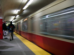
As a kid growing up in upstate New York, I loved to visit my cousins and grandparents in Boston. Boston, to me, felt like a REAL city because it had a subway. I vividly remember riding the T when we would go downtown. When I was 15, my family moved to the area and I began to explore the area using the buses and subways.
The Red Line of the T (which is how locals refer to their subway system) ended right at the border of my town, Arlington. It was an easy enough bus ride, or, bike ride, to the last stop. While in high school, a friend’s father told me that in the 1980s the MBTA almost extended the Red Line into Arlington. How much better would that have been, I thought. Being a visual learner, I could imagine such an extension. I wanted to see what this would have looked like on a map, but I had no idea where I could even find one.
I entered college in downtown Boston to study Industrial Design. I had picked up some Photoshop skills in high school, but now I was learning how to put them to use. Living off the Green Line, I learned how to navigate the city via mass transit. It was at this time that I discovered that on the internet, there were transit fans who had shared the history of the system. It feels funny to say this today, but in 2002 the internet was not what it is, over 20 years later.
I read about the unbuilt Red Line extension, as well as many more. As I looked at the map, I started to see other potential connections. But there were still no maps! Perhaps I could make my own? I didn’t know you could do that. So, I opened up Photoshop, chose the line tool, and the rest is history.

The maps I present here are crude. But they represent the beginning of my journey.
As such, many of these maps contain errors. But the basics are all there. The futureMBTA was how I learned how to make maps and think critically about history. It is why this website exists in the first place. The content was written when I was first researching the MBTA and Boston transit history in the mid 2000s. Much has changed since then, and my plans have evolved as I learned more and talked to people about my ideas.
While others have picked up the torch of fantasy expansion maps, I have moved on. I keep this project here as an archive of work. I do not update these ideas, as some are very much out of date. They exist to show how my early work has evolved, and inspire new generations to dream.
theRedLine
Images from around the Red Line
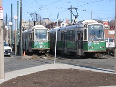
The Red Line is the longest subway line in the T. It is made up of two branches and a High Speed Light Rail Line. Both branches start at the Arlington/Cambridge border at Alewife. They both travel along the line into Somerville, Cambridge, Central Boston, and South Boston. In Dorchester the lines split after the JFK/UMass stop. The A branch travels to Ashmont and is the oldest branch, finished in 1924. At Ashmont you can transfer to the Mattapan High Speed Line which is a high speed light rail line which runs along the border of Boston and Milton, terminating in Mattapan. The second branch, the B branch, splits off after JFK/UMass, skipping Savin Hill, and makes its way to Braintree via Quincy. This branch was started in 1971 and was finally completed in the early 1980s. There is also a C branch which is any train headed towards Alewife from either branch.
The Red Line was originally envisioned as an elevated line, like the old Orange Line, that would go from Harvard Sq in Cambridge to Bowdoin Sq in Boston where it would connect with the Tremont St subway. After it was decided to keep trolley traffic and subway traffic separate in the Tremont St subway, a new plan emerged which had trains running elevated from Harvard Sq to Bowdoin Sq but then diving under Boston Harbor to Maverick Sq in East Boston, but due to disputes between the Boston Transit Commission (created by the state to plan the subway system) and the Boston Elevated Railroad Company (BERy, the corporation building the system) the tunnel under the harbor to East Boston was only built for trolleys. Eventually the tunnel was converted to heavy rail for the Blue Line but the clearances were far too narrow for the larger and wider elevated trains.
On the other side of the Charles River the people of Cambridge were up in arms about an elevated subway running down the main thoroughfare of the city, Massachusetts Ave. By the turn of the century elevated railroads were regarded as a dirty nuisance. There were also arguments over how many stations there were to be built. Some people wanted 5 stations so to better serve the city itself while others wanted fewer so that suburbanites could reach downtown Boston faster. Eventually it was decided to build the line as a subway with three stations, the terminal at Harvard Sq being a giant transfer station for trolleys coming in from the suburbs of Arlington, Belmont, and Watertown.
The original Red Line only went from Harvard Sq in Cambridge to Park St station in Boston. Slowly over the next few years the tunnel was extended to South Station via Downtown Crossing (Washington, as it was originally known). A little known fact is that the tunnel was constructed with two levels, the bottom level for subway trains and the top level for trolley cars to go from South Boston to Park St. The top tunnel was never used by trolleys but is currently used as the mezzanine from Park St to Downtown Crossing. There is also a section of tunnel from Downtown Crossing to South Station which is used as offices and storage. Soon the line was extended to Broadway in South Boston where a large underground two level trolley transfer station way built but this was rendered obsolete when the line was extended again to Andrew Sq where an even larger above ground transfer station was built and remains to this day, though it was completely rebuilt in the 1990s.
The first branch was built to Ashmont from Andrew Sq. It was built at grade along a former New York and New Haven Railroad line which served Dorchester and Mattapan. Two of the new stations, Fields Corner and Ashmont, were built as large transfer stations. Due to community opposition, however, the last leg of the line was built as a high speed trolley line from Ashmont to Mattapan. Had the subway been extended to Mattapan it was conceived to build a second branch from Andrew Sq into the heart of Dorchester along the Fairmont branch of the NY&NH Railroad, creating a giant loop serving Dorchester.
The second branch to Braintree was built later in 1971 but had been in the planning stages since the 1940s. Quincy and Braintree were both good sized cities with booming shipyards and large populations but were only served by commuter trains which were shut down in 1959. All throughout the 1960s plans were drawn up but no money was appropriated as traffic along the Southeast Expressway from Boston to Quincy built up. After the Freeway Revolt in 1970 monies from highway projects were transfered to rapid transit projects allowing the Braintree branch to finally be constructed.
At the other end, the new money allowed the Red Line to be extended from Harvard Sq to Alewife. This was also a plan from the 1940s (click here for a map). The original plan was to extend the Red Line out to Route 128 along the old Lexington Branch of the Boston and Maine Railroad that went from Alewife through Arlington, Lexington, and Bedford to Concord. Enough money was available to build the line to Arlington Heights with new stations at Porter Sq, Alewife, Arlington Center, and Arlington Heights. Due to the great work of Speaker of the House “Tipp” O’Neill in securing funds, an additional station was planned in Davis Sq in Somerville, a city that had no subway but one of the largest population densities in the state. Arlington residents didn’t like the idea of increased traffic and certain urban elements entering their quiet suburban town. The plan was eventually voted down and the line only got as far as Alewife, although the tunnels for the subway do actually extend into Arlington for storage. The Right-of-Way for the subway was eventually converted into the Minuteman Commuter Bike Path
Northwest Extensions
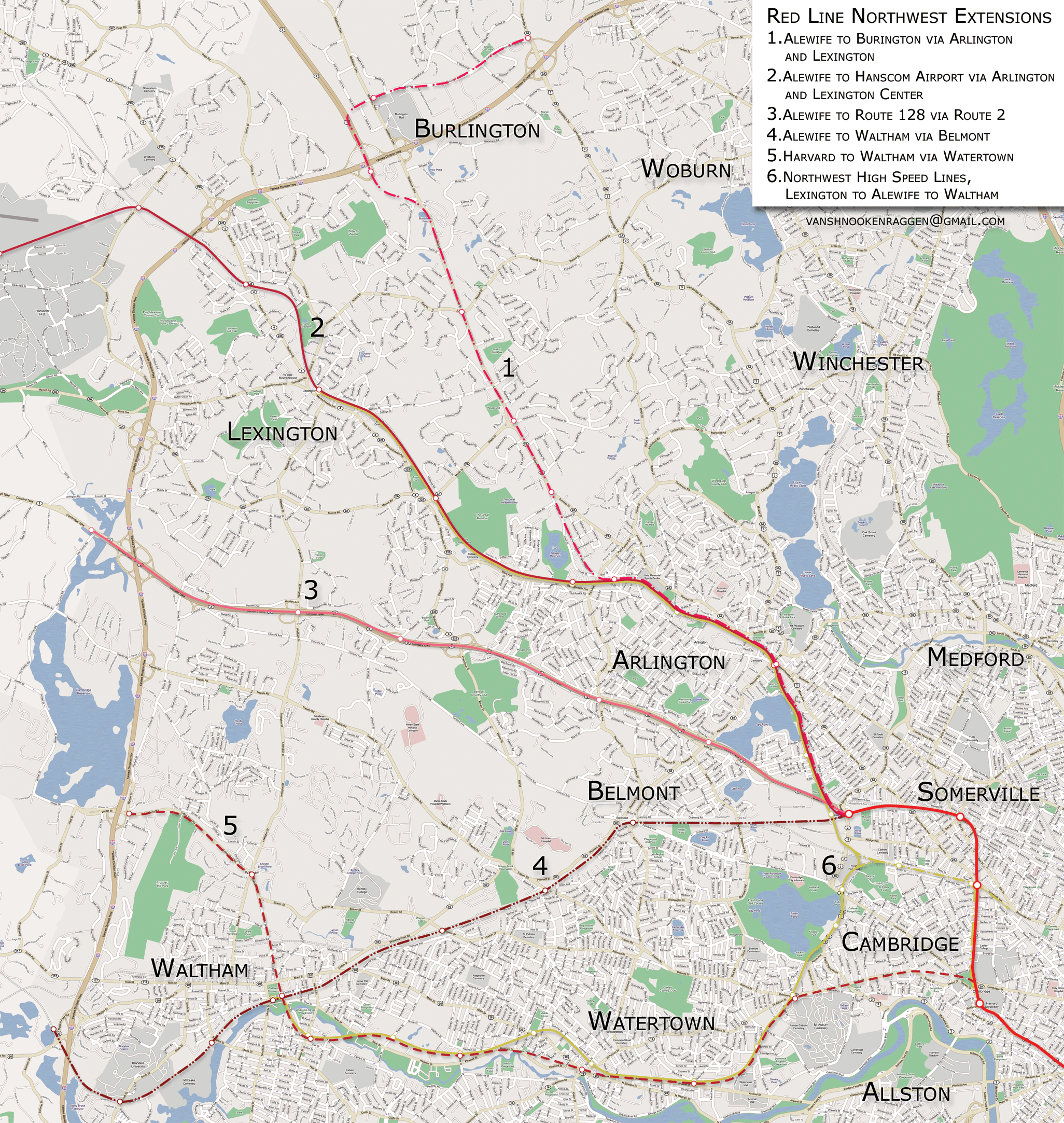
I am going to break up the possible extensions geographically, those that head northwest from Alewife and Harvard, and those that head south and south east from Andrew Sq and Braintree. The first group are those that head northwest. There are 5 total proposals and an additional proposal for a high speed light rail line. A few of these proposals are taken from BERy, MTA, or MBTA records, but a few are of my own imagination.
1. Alewife to Burlington via Arlington and Lexington
The first proposal is an extension northwest from Alewife under the Minuteman Bike Path through Arlington to Arlington Heights where, instead of following the bike path, the line would turn north under Route 3 through eastern Lexington and parts of western Woburn. The line would follow Route 3 until it reaches the area just south of Route 128 where the line would veer west to an Alewife-like park-and-ride facility. The line could stop here but it could also be extended into Burlington along the Burlington Mall road with 1 or 2 additional stations. There could be 6 to 8 stations along the entire line.
2. Alewife to Hanscom Airport via Arlington and Lexington
The second proposal is the original proposal from the MBTA for the Red Line extension in the 1980s. The line would be built below grade and at grade along the former Lexington Branch of the Boston & Maine Railroad, terminating at Hanscom Airport. The line would travel through Arlington Center and Lexington Center, both pedestrian friendly town centers with active street life and active night life. A park-and-ride station would be built near Route 128 in norther Lexington. The problem with this idea is that it would probably face the same opposition, if not more, that it did when it was first proposed. In the late 1990s and early 2000s there was a push by the operators of Hanscom to allow for more commercial flights but this was stopped due to intense public outcry. A subway to Hanscom would be seen by many as a step towards more commercial flights. There is also the development issue. Lexington and Arlington both have histories of NIMBYism and while the population demographics have changed since the original proposal, they have also grown accustomed to the Minuteman Bike Path. To keep construction costs down the MBTA would want to build the subway at grade rather than in a tunnel. This would mean destruction of the much loved bike path. While more people would be in favor of the subway if the bike path was saved, there would still be many people worried about increased traffic and development in already developed areas rather than allow for smart development in areas with high auto-dependency and more room for development.
3. Alewife to Route 128/I-95 via Route 2
Proposal 3 is the alternative proposal for extending the Red Line to Route 128. The line would be extended along the median of Route 2 from Alewife to Route 128. This would be the most straight forward and direct way to connect the Red Line with Route 128 but would not go through any developed areas, except southern Arlington and Arlington Heights, though an subway here would need to be in a tunnel under the highway due to topography and ROW. This extension would allow for transit-oriented development in southern Lexington and northern Waltham. The stations, 4 to 6 of them, would be located at highway interchanges which would mean that people would still need to maneuver around high speed cars. This kind of rapid transit/highway infrastructure exists in the suburbs of Chicago and is an affordable alternative but it would not allow for pedestrian oriented development the way other proposals would.
4. Alewife to Waltham via Belmont
The fourth proposal is an old BERy alignment that would use the Fitchburg branch of the Boston & Maine Railroad from Alewife to Waltham via Belmont. The extension would parallel the existing commuter rail OR would replace it with new commuter rail track being laid along the median of Route 2, the same alignment of proposal 3. The new extension would add additional stops in Waltham at Beaver Rd and Main St and could possibly be extended from Waltham Center to Route 128 to a large park-and-ride facility. This extension would serve a large, dense, transit dependent population while opening up Waltham the same way the Red Line extension did to Davis Sq in Somerville. Moody St in Waltham is already active at night and many people see Waltham as a more affordable alternative to Boston while still close to the city. If the Red Line was extended it would allow for the closure of the commuter rail station at Waverly which would speed up trains from Fitchburg. The station at Route 128 would also serve the large high-tech companies along Route 128. However due to ROW constrains, private property would have to be taken and the ridge along which the tracks run would need to be dug into.
5. Harvard to Waltham via Watertown
The fifth proposal is the only one that doesn’t begin at Alewife but rather just north of Harvard Sq. The line from here would turn west and travel under Brattle St to the border of Cambridge and Watertown where it would then follow the alignment of the abandoned Watertown Branch Railroad to Watertown Center and on to Waltham. The line could terminate in Waltham Center or could continue north and west around Prospect Hill to Route 128. This northern section would open up land for development north of Waltham, and this would be the biggest benefit to this extension. The land through which the ROW runs is either under-used industrial or commercial strip, including 2 malls. All this land could be redeveloped as dense TOD’s with large amounts of housing for students at Harvard and MIT. It would also serve a large amount of people who only have limited bus service into Boston and Cambridge as well as connecting Waltham to Boston. Unlike with the extensions through Arlington and Lexington, the current ROW is not a bike path, though once the line is built a bike path could then be constructed above or along side it.
High Speed Lines
One of the most over looked parts of the entire MBTA system is the Mattapan High Speed Line. This is a trolley line that runs on its own ROW through extreme southern Dorchester and Milton. It goes from Mattapan Sq to Ashmont Station through a nice suburban area and is very popular (like the D branch of the Green Line). The proposal (number 6 on the map) shows a collection of different ideas as one large network. The lines would use the Watertown Branch ROW and the Lexington Branch ROW to form a large crescent, connecting to the subway system at Alewife or extending to Porter Sq along the commuter rail tracks. As this would be light rail the line would run at grade and could contain more stations. It would also help preserve the suburban feel many of the communities through which it would run have while connecting them to the central subway faster than a bus. The lines would also be much cheaper than a conventional subway and if the demand rose enough the line could easily be converted to heavy rail if it was constructed properly to begin with.
Southeast Extensions
The second section is those extensions that would head south and southeast, either from Andrew Sq in South Boston or Braintree. There are large sections of Dorchester that go under served while a lightly used commuter rail line with few stops puts transit out of their reach. Also, the south shore of Boston is the fastest growing area of the state and the Southeast Expressway is constantly clogged with congestion, spewing toxins over Dorchester and South Boston. The extension to Braintree in the 1980’s helped but development kept coming. Restoration of the Old Colony commuter rail lines to the south shore also have helped but development still remains suburban and auto-dependent.
1. Crosstown from Central Sq to Andrew Sq via Mass Ave
The first proposal is a “crosstown” line that would spur off the Red Line between Central Sq and Kendal Sq in Cambridge and travel under Mass Ave through the Back Bay and South End in Boston, either connecting to the Red Line before or after Andrew. The line could be color-coded differently and possibly run from Harvard Sq to JFK/UMass allowing people to bypass the congested central “square” of the subway lines downtown. It would work the same way a highway bypass would work, diverting people away from downtown who need to get to Cambridge or Dorchester. The line would also connect Harvard and MIT to the Longwood Medical Area and the Boston Medical Center, along with UMass Boston. If the Urban Ring seems too expensive and complicated, this could be a good alternative.
2a/2b. Andrew Sq to Route 128/Mattapan via Fairmont
These proposals go back to the original BERy idea to create a rapid transit loop through Dorchester. 2b would complete the loop, starting at Andrew Sq running to Edward Everett Sq and under Columbia Rd where it would connect with the Fairmont commuter rail ROW, following that south to Mattapan. 2a would continue the line all the way along the Fairmont branch to Route 128. This would serve a large population of transit dependent people who’s only access to downtown is by bus. This proposal is also the idea behind the Indigo Line which would construct additional stations along the commuter rail branch. As this is currently underway, and the fact that this is the only other train route into the city from the southwest, the prospect of converting the line to rapid transit is low but is still possible.
3. Andrew Sq to Dedham Center via Fairmont
Proposal three is a short spur off of proposal 2a using an abandoned stretch of track from Readville to Dedham Center. The extension would have 2 stations and serve a medium density neighborhood. As this proposal is only feasible if the previous one is constructed, the chances for this are low.
4. Quincy Adams/Braintree to Weymouth
This proposal has the Red Line creating a forked tongue at its southern end. There is an interchange just between Quincy Adams station and Braintree station that is currently used for the Greenbush commuter rail branch. This short extension would serve Weymouth and eastern Quincy. Trains would either travel to Weymouth first and then to Braintree before heading back to Boston or vice-versa. This would catch traffic coming off of Route 3a that would either come into the city via I-93 or fill up the garages at Quincy Adams and Braintree.
5a/5b. Braintree to South Weymouth, Brockton, or Route 24
These proposals are open ended. The south shore is currently booming and is in desperate need of transit. The Old Colony commuter rail branches are a good start but rapid transit would be able to serve more people more of the time. The Red Line could possibly be extended to any number of towns south of Braintree: South Weymouth Air Station is going to be converted into a housing and retail complex and rapid transit would enable smart growth in the area. An extension to Route 24 in Randolph would take cars off the road before they got to Route 128 and I-93, and an extension to Brockton, though quite far, would be a huge boon to a city seen as an affordable alternative to Boston. There are many different possibilities so it is best to keep all options open.
theGreenLine
Images from around the Green Line
The Green Line is part of the oldest subway in America. During the 1890s Boston was growing at a fantastic pace. The harbor was booming and the factories and mills around eastern Massachusetts were pumping at top speed, manned by wave after wave of new immigrants from Europe that were pouring out of the continent and onto the New World’s shores in hopes of a better future. The transportation for the working man was the trolley. First drawn by horses and eventually drawn by electricity, trolleys were the technology of the day when it came to commuting and were very successful at transporting many people many miles from their homes to their work. But they were too successful; trolleys packed the streets in downtown Boston so tight that it was quipped at the time that it might be faster to get to work by running along the tops of the trolleys stuck in traffic.
Traffic like this became a reality in cities at the end of the 19th century. Before, most communities would mix work and commerce in with residences. But when the technology improved to allow people to move out of crowded downtowns and live in the suburbs, which bad begun to grow around cities at this time, and people began commuting to work over longer distances. But what happened was as more people began to move into the suburbs there would be greater needs for more trolleys to ferry them to and from work everyday (This very same thing has happened with highways and the automobile and will undoubtedly happen with the next great, affordable, transportation improvement). Many solutions were floated at the time, such as building an elevated railway downtown (which proved objectionable to the wealthy merchants and bankers living along Beacon Hill), a new street that would run down the area between Tremont St and Washington St (which proved objectionable to the property and business owners in the area), and a subway, which was a relatively new technology that had only been tested in a couple of European cities and were under consideration by many more, including a few American cities. A commission was set up to study the ideas and in 1894 they recommended that a combination subway and elevated train line be built with branches connecting Boston to its new suburbs as if spokes connecting a hub to a wheel.
The first section that was to be constructed was a subway from Boylston St to Park St and then on to Scollay Sq (today’s Government Center) and North Station via Haymarket Sq. The tunnels would collect and connect the trolley lines coming from the north to those coming from the west and south. The first section opened in 1897 from Boylston St to Park St. As soon as the entire subway was built it was heralded as a success and soon new transit line were being constructed to Roxbury & Charlestown (Orange Line), Cambridge, & South Boston (Red Line), and East Boston (Blue Line) [Note: Each subway was not referred to by colored lines until after 1967 when the new MBTA modernized the subway graphics, forever defining the subways in Boston as “The T”].
The Green Line was soon expanded and its role as a collection tube for trolleys soon changed as commuting patterns changed. People were moving further and further out, requiring new tunnels and stations further apart for quicker travel into the city. A new subway to Kenmore Sq under the Back Bay was opened to speed travel to the west as was a new elevated line to Lechmere in Cambridge, past North Station, was constructed. Eventually even this was not enough and plans were proposed to convert the entire line to heavy rail and further expand. But this time Boston was in an economic depression, soon to be followed by the entire nation, and very little was done in terms of expansion (Kenmore station was built in anticipation of a future conversion at this time; the middle two tracks were built on lifts over a sunken track pit that was the correct height for heavy rail trains). In the early 1940s Boston received some monies to construct the Huntington Ave subway (todays E branch) but what was built was a far cry from the original proposal to construct a new subway under Stuart St in the Back Bay and out to Mission Hill.
After the war Boston took a much longer time to emerge from economic stagnation then the rest of the nation. The next addition to the Green Line was in 1959 when the Riverside Branch (D) was opened. This was continuing in the tradition of preparing for heavy rail conversion as the Riverside Branch was a former commuter rail line through Newton that had shut down and ran in a dedicated right-of-way (trolleys ran in mixed traffic in the streets). This new branch proved very popular and soon put a strain of the rest of the system for trolley cars. As was the case in many cities after the war buses were quickly replacing trolleys, and in Boston it was no different. Boston had been converting it’s trolley lines over and by the 1960s there were only a handful of trolley lines left. The first line axed was the line from Park St to Egelston Sq via the South End. It was cut back further and further until it became a short shuttle line from Lenox St in the South End to Boylston St, but soon this was removed. The remaining lines were named during the MBTA’s design overhaul in 1967. The new branches are what you see today with two major exceptions; the A Branch from Watertown to Park St via Brighton and Allston and the E Branch to Forest Hills (Arborway). These were cut back and “temporarily” taken out of service due to budget cuts in public transit.

What happened to the Green Line happened all over the nation at this time so it is not fair to blame the MBTA solely. But even with renewed interest in rapid transit lines over new highways, they have not seemed to be able to capitalize on new federal monies (due mostly to the Big Dig which scared many lawmakers away from continuing to give Massachusetts federal dollars). After they were sued in the 1990s by the Conservation Law Foundation, the Commonwealth pledged to invest in public transportation to offset the negative effects of the Big Dig. Commuter rail lines out to the suburbs represented by powerful state senators were constructed but inner city transit was only left scraps. Two prominent projects were the extension of the Green Line to Union Sq in Somerville and West Medford, and the restoration of the Arborway trolley line to Forest Hills. The state has since reevaluated their priorities to public transit and have pledged to construct the Green Line extension to Somerville and Medford but once again passed on restoring the Green Line to Arborway (most likely at the behest of Mayor Menino who is notorious for disliking street running trolleys).
Central Subway Improvements

The biggest problem facing the Green Line is that it was never designed to be operated the way it is today. The purpose of the original subway was to take trolley cars (which usually ran as single cars back in the day) off the crowded downtown streets. The idea of trolleys as rapid transit in the same sense as heavy rail like the Orange and Red Lines didn’t come around until after most of the system was built. The Boston Elevated Railroad knew this when they were planning to expand the system in the 1920s and planned converting the Green Line into a heavy rail subway like the Blue Line (which was an old trolley subway converted to heavy rail). They planned on running the Blue Line from Bowdion to Park St and then down Boylston St to Kenmore Sq where a new subway under Comm. Ave would take it into Brighton. The curve at Boylston St would have been enlarged so it was not as tight. The second section of the Green Line planned was partially constructed, the Huntington Ave subway was part of a much larger plan that had the subway continuing under Stuart St in the Back Bay, connecting to the Green Line using the Tremont St tunnels (the tracks leading off to the left on the image above, currently abandoned) that run from Boylston St south to where Tremont St splits into Shawmut St. Because of funding shortages and a prolonged economic depression the full plans were never fulfilled and where the Huntington Ave subway connects to the Central Subway at Copley has proved to be the worst bottleneck in the entire system.

The best investment of capital funds that the MBTA could possibly make would be to realign the Central Subway. Here is a track schematic to illustrate my plan. The this colored lines represent the tracks, the thick colored lines represent the station platforms, dashed lines mean the tracks are below the top tracks.
A – Remove the bottleneck of the Copley Junction by dropping the Huntington Ave subway under Copley station into a second two track tunnel to just past Arlington station where it would ascend to meet the current tracks.
B – Rebuild Boylston station. Realign the 4 tracks from Park St south into the Tremont St tunnels, eliminating the curve, and build a new two track tunnel under Boylston station to continue on to South Station. Also, build a set of tracks that dive under and bypass Boylston station entirely creating an express track from Park St to Copley Sq.
C – Build a second two track tunnel from Park St to Government Center, rebuilding Government Center so there are two parallel platforms and a third platform below that would serve the Blue Line and the loop track coming from the north. Also create a turnaround loop that dives below the tracks continuing to Haymarket. This realignment will fix the second worst bottleneck in the system, the stretch of subway from Park St to Government Center that was only built two tracks wide.
D – Stuart St subway, which would be an alternative to choice A, would take the Huntington Ave subway into its own tunnel and connect to the Central Subway via the abandoned Tremont St tunnels. Provisions would be made to extend the Tremont St tunnels down to Dudley Sq. This plan also calls for extending the Huntington Ave subway down Huntington Ave into Brookline to connect to the Riverside branch, rerouting the D and E branches into a new subway and expanding capacity in the Boylston St subway.
What all this realignment would accomplish is this: It would take all the traffic coming off the D and E branches and funnel them into a new tunnel thus expanding capacity along the Boylston St subway by 50%. It would run the C branch to South Boston Waterfront thus connecting the area to offices, hotels, and entertainment in Back Bay. It would speed up the B branch by eliminating the curve at Boylston and allow for increased capacity. It would also allow more trains to go on to Government Center thus taking pressure off trains at Park St and two new platforms at Government Center would better handle traffic than the current oddly shaped platform. This, I feel, should be the MBTAs number 1 priority.
Ring Routes
The Urban Ring is a transit plan put out by the MBTA to connect all the transit lines (subway, bus, and commuter rail) that come into downtown Boston with a ring of transit. The purpose of this is two fold; the first being to take pressure off of the 4 major downtown transfer points (Park, State, Gov’t Center, and DTX), and second to connect large job centers, primarily Kendall Sq and the Longwood Medical Area. The current plan is a three phase process starting with improved crosstown bus service, then moving to Bus Rapid Transit -BRT- (e.g. Silver Line), and finally constructing a subway line either using Orange Line heavy rail or Green Line light rail.
The idea for an urban ring is not new. The first instance of a transit line encircling Boston was put out by Robert Gourlay, a Scottish writer and urbanist. When he first came to the young United States in 1817 he realized that the new nation would be building many new cities and that there had to be a scientific way to do so. He began crafting ideas for cities, making him one of the first urban planners. In his “General Plan, for enlarging and Improving the City of Boston”, Gourlay proposed something completely radical: fill in the Back Bay and line the Charles River with a park and train line. He also proposed connecting the Providence, Boston & Worcester, and Fitchburg train terminals with underground tunnels (we don’t have this either). Nothing came of Gourlay’s plan, though he must have planted a few seeds in the minds of Bostonians.
(I mean to have an image of Gourlay’s plan but I can’t find it online. You can see it in the book “Inventing the Charles River” by Karl Haglund)
The problem most people have with the current plan is that it doesn’t serve enough areas and that it relys mainly on slow moving buses in mixed traffic. I do want to go on record saying that I am all for improved crosstown bus
service but I am not for relying completely on buses. I do believe that any serious transit plan needs to take them into account and to propose ideas that would improve bus traffic (dedicated lanes), but in the end any urban ring proposal needs to center around an actual subway line. Here is my proposal:
To start with, this is not just a proposal for the urban ring but it is a fundamental rethinking of how the Green Line would operate.
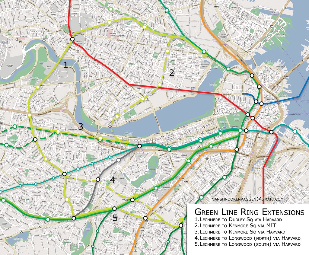
What this map shows is a series of rings formed by connecting the ends of the Green Line through Cambridge and Boston. The Green Line as we know it today would function as half of the ring while the other half could go through Harvard and Allston (#1) or Kendall Sq (#2). Since the southern end of the Green Line has multiple branches this gives us more options for where to connect the ring. The first connection would be to Kenmore Sq (#3), either directly under the Charles River or by a new tunnel under Comm. Ave. The next possibility would be under Huntington Ave (#4), connecting Longwood into the ring. The last option would be the most dramatic, connecting the ring to Dudley Sq (#5) where a new tunnel under Washington St would connect the ring into downtown.
What would happen to the trolley service we have now is this:
– B Line would be placed in a tunnel to Brighton where it could terminate or continue to Boston College.
– C Line would cease going to North Station but would instead travel to South Boston via a new tunnel under Essex St (what Silver Line Phase III is planning on building).
– D Line would connect to the Huntington Ave subway and shuttle service would be instituted along the stretch of track connecting Brookline with Kenmore Sq.
– E Line would be truncated or switched to Washington St tunnel.
If two of the connections were built then this would give the T much more room to try different services and to reroute trains if one becomes disabled.

The next phase would be to connect the northeastern suburbs.
Unlike the first phase, these lines would only feed into the new urban ring tunnels, not the Green Line tunnels.
The three options as thus: Construct a new line, both in tunnel and at grade, to connect Lechmere with Everett, Chelsea, and Logan Airport (#1). This proposal is currently in the long term plans for the actual Urban Ring but only as BRT. The next would be to use the under-used Saugus Branch ROW that runs along Everett to Malden and Saugus before terminating in Lynn (#2). Service here could terminate at a Park-&-Ride facility at the interchange at Route 1 or continue to Saugus and Lynn. The last options is a line through Charlestown in a tunnel to Chelsea and on to Revere (#3). This would be the most expensive since express bus service covers this basic route today, but I just threw it in there anyway.
This is no simple plan and will most certainly cost billions of dollars. But if you only think about it in terms of how much it’s going to cost you then you aren’t seeing the forest for the trees. The Green Line today is a relic of Victorian era transportation and it is evident every time you ride it. Installing a brand new artery that doesn’t funnel people in and out of the city twice a day but circulates them throughout the business areas, residential areas, and entertainment areas will completely change the way people think about living in the city.
The problem with the current plan for the Urban Ring is that it still clings to the transportation theories of the mid 20th century where people come in from the suburbs at 8am and then leave at 5pm. While there will always be commuting into the city, the city cannot grow and prosper when this is the only option. We need a new way of thinking about how mass transit can strengthen a city and I think that these proposals are a good first step.
theBlueLine
Images from around the Blue Line
The Blue Line is the shortest of all the rapid transit lines in Boston. It mainly serves the north shore and Logan Airport, however it does not go directly to Logan but there is a free shuttle in-between.
The Blue Line was the first subway in the world to go under a major body of water, Boston Harbor. It goes from Bowdoin Square near Government Center to Wonderland dog track in Revere. It is fast and relatively clean (it has some of the newest stations and cars). The MBTA had been rebuilding the stations along the Blue Line to make them handicap accessible so the stations are nice and new. Also the platforms are being lengthened to allow for 6 car trains. This, however, will be the death for Bowdoin stop; There is a tight loop which will make it impossible to extend the platform. Bowdoin will be permanently closed when the upgrade is complete. The new terminus will be Government Center, just a few blocks away. Government Center is one of the busiest and most oddly designed stations in the system. Formerly Scollay Square, Government Center is a result of urban renal and 1960’s architecture. Plans have been in the works to replace the station with a much nicer and brighter one for about a decade but so far no work has begun. Unfortunately it probably won’t make the rest of Government Center much nicer.
The original Blue Line ran from Court St at Scollay Sq to Maverick Sq in East Boston and was used by trolleys (like the Green Line). The tunnel was soon extended to Bowdoin Sq where a portal was built to allow trolleys to continue to Harvard, though this service was stopped when the short line was upgraded to heavy rail in 1924. The portal remained open until the 1950s to allow cars to access the Elliot Shops in Harvard Sq. When the Blue Line shops at Orient Heights opened the portal was closed.
The second section of the Blue Line started out as a narrow gauge railroad from East Boston to Lynn, connecting to downtown Boston via a ferry. Narrow gauge means that the distance between the two steel tracts is narrower than standard track. This makes it cheaper as the right-of-ways don’t need to be as wide. The railroad, the Boston, Revere Beach, & Lynn, was built to serve the amusement parks on Revere Beach, as well as connect Lynn and Winthrop to Boston. The railroad folded in 1940 and the right-of-way was soon purchased by the MTA, the predecessor to the MBTA. The MTA extended the Blue Line from Maverick to Orient Heights and then on to Wonderland. The right-of-way existed to continue the line to Lynn but funding problems have sidelined the project to this day.
Northeast Extensions
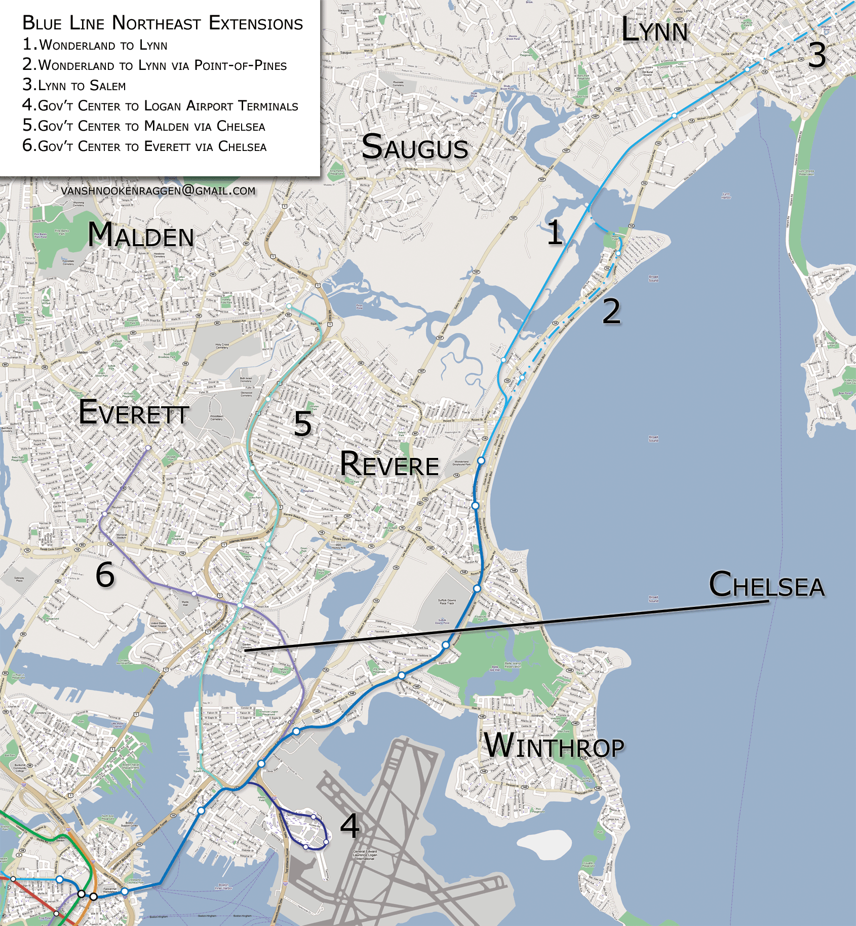
I am going to break up the possible extensions geographically, those that head northeast from Maverick, and those that head south and west from Government Center. There are 6 total proposals A few of these proposals are taken from BERt, MTA, or MBTA records and a few are of my own imagination.
1. Wonderland to Lynn
The first extension is the original legend. New York has the Second Ave. Subway, Boston has the Blue Line to Lynn. Proposed as far back as the 1940’s, the Blue Line would be extended from Wonderland to Lynn along a viaduct connecting to the Newburyport Branch Commuter Rail right-of-way. The line would continue into Lynn terminating at the large train station and parking garage in Lynn center. This extension is a high priority for the MBTA but it seems that every time funding appears it is siphoned off into other projects. The line was to be extended in the 1970s and 1980s but funding went instead to the Red Line and Orange Line extensions. Funding has appeared again but it looks like it will go towards the Green Line extension to West Medford and commuter rail expansion to New Bedford and Fall River.
2. Wonderland to Lynn via Point-of-Pines
The second proposal is the same as number 1 but differs as it is rerouted through the Point-of-Pines section of Revere. This is the original right-of-way of the Boston, Revere Beach, & Lynn railroad and would serve more people but it would also require taking of private property and the introduction of frequent trains through a residential area accustomed to peace and quiet.
3. Lynn to Salem
This would further extend the Blue Line to Salem via Swampscott. This route would parallel the Newburyport Branch Commuter Rail, terminating right before the train tunnel under downtown Salem. There would be new stations in Swampscott and South Salem to serve Salem State College. The line could be extended even further to Danvers via an old freight train line or to Beverly but this would require a new tunnel under downtown Salem and new bridges.
4. Government Center to Logan Airport Terminals
This would extend the Blue Line to the Logan Airport terminals. This is probably the best possible extension of the Blue Line in terms of ridership to distance. It would also connect Downtown to the airport which is only accessible via buses or cars. This should have been built at the same time as the Big Dig but service to the airport was instead routed through the Silver Line, which for some reason doesn’t connect to the Airport station on the Blue Line.
5. Government Center to Malden via Chelsea
This extension would connect Chelsea and Revere to downtown Boston. The line would just off the current Blue Line after Maverick Sq in East Boston and head to Chelsea in a tunnel under the Chelsea River. The line would then head north, connecting to Route 1. Here the median/middle two lanes would be converted to track for the Blue Line which would then head to Linden Sq where a large park-and-ride would be constructed to collect the car traffic that eliminating a lane of traffic on Route 1 would displace.
6. Government Center to Everett via Chelsea
The last extension would connect to Chelsea and Everett. After Airport Station on the Blue Line the line would travel over the Chelsea River using an abandoned rail right-of-way, connecting to Chelsea along the Newburyport Branch Railroad. Heading west the line would then turn north into central Everett. Most of the traffic from Everett reaches Boston via Sullivan Sq so this line would take pressure off Sullivan, both the T stop and Rutherford Ave.
South and West Extensions
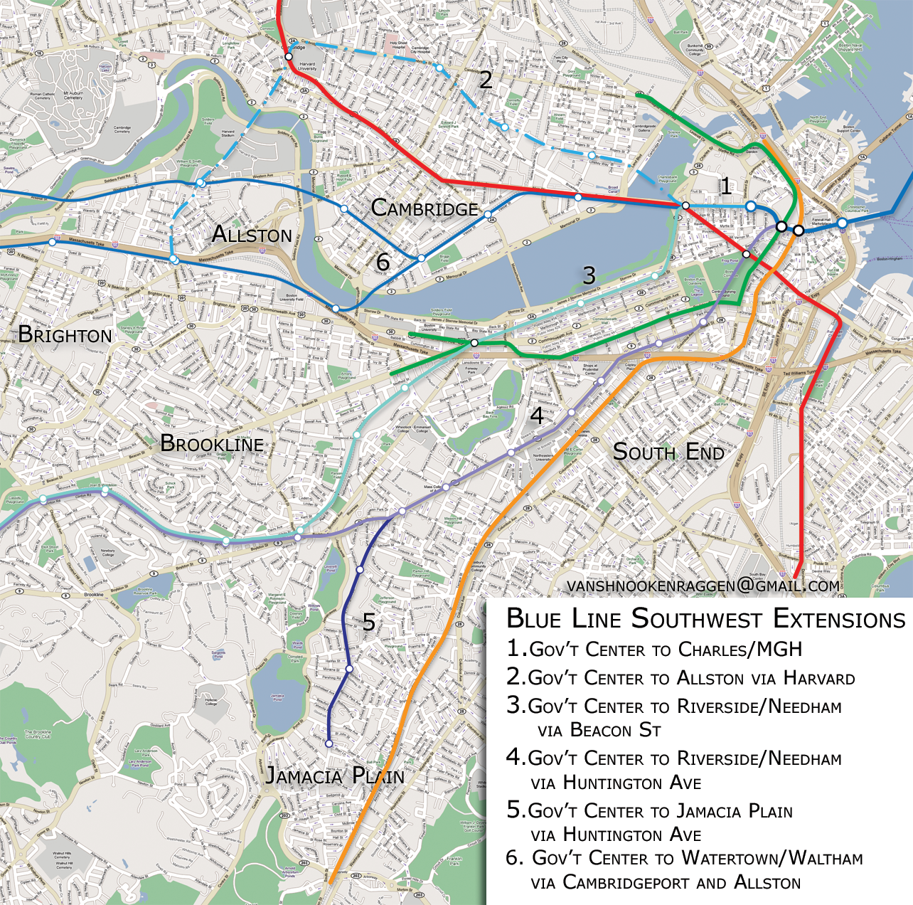
The second set of extensions are those that would extend from the other end of the Blue Line. Currently there is only one proposal, to extend the Blue Line from Government Center to Charles/MGH. This extension was part of the law suit against the state mitigating the Big Dig. Currently there is enough money to study the proposal but no firm funding to build it. The other extensions are variations of BERy or MTA proposals, and one is my original.
1. Government Center to Charles/MGH
This extension would connect Government Center with Charles/MGH. Bowdoin Station, the current terminal for the Blue Line, is going to be closed because of low ridership and the fact that it cannot be expanded to handle the 6 car trains. Bowdoin is also only a few blocks away from a new Government Center headhouse currently under construction. The Blue Line and the Red Line are currently the only two lines that do not intersect. This would connect these two lines as well as take pressure off the Green and Orange Lines between Park St, Downtown Crossing and Government Center, State St.
2. Government Center to Allston via Harvard
This would further extend the Blue Line under the Charles River into Cambridge. The purpose of this line is to take pressure off of the Red Line in central Cambridge. A new station would serve northern Kendall Sq as well as southern Lechmere (and the Cambridge Side Galleria Mall) as well as Inman Sq and southern Union Sq in Somerville. The line would connect to Harvard and then continue under the Charles River again into Allston, serving Harvard’s new campus as well as the college/residential area of Allston Center. This would allow transportation between Allston and Cambridge without having to construct a costly new Urban Ring transit line further away from the central city than planned.
3. Government Center to Riverside/Needham via Kenmore Sq
This extension would continue from Charles/MGH to Kenmore Sq under Embankment Road and Beacon St. From here the line would connect to the D branch of the Green Line to Riverside and possibly a new branch to Needham. This would take pressure off the central Green Line subway but it would cut off the Green Line from the Riverside Yards.
4. Government Center to Riverside/Needham via Huntington Ave
Extension 4 would extend from Government Center but head to Park St instead of Charles/MGH. From here the line would head to Stuart St and then connect with the Huntington Ave subway (E branch). The Huntington Ave subway would then be extended to Brookline Village and connect with the D branch to Riverside or Needham. This would be a better alternative to the previous extension as it would serve the commercial section of the Back Bay rather than the residential section. It would also utilize existing subway tunnels so it would be cheaper. This extension would get rid of the bottle neck in the central Green Line subway created by the Huntington Ave subway.
5. Government Center to Watertown/Waltham via Cambridgeport and Allston
The last extension would create a short spur off of the Huntington Ave subway at Brigham Circle that would dive under Mission Hill and into Jamaica Plain. This would try to serve what the current E line would stop serving if the Blue Line were to use the Huntington Ave subway. Only a few stations would be needed but the population might not justify the expense. The 39 bus took over for the E branch when it was truncated in the 1980s due to the extension of the Orange Line through the area.
theOrangeLine
Images from around the Orange Line
The Orange Line has changed more since it was first built than any other transit line in Boston. If you were to compare today’s Orange Line with yesterdays, there are few similarities.
The old Orange Line was known as the Main Line or “El” because most of it was on elevated track. It ran from Everett, though Charlestown, over the Charlestown Bridge, turned toward North Station, and then descended underground before Haymarket Sq. If you go by the Charlestown bridge you can see there is a center structure where the trains used to run and if you look at the pavement you can see where the supports once were. The underground portions of the Orange Line are just as curious as the elevated tracks. The platforms of each station are built not directly across from one another, like in most subway stations, but diagonal. That is to say, if you were to look down the track from the platform you are standing on, you would see the other platform. The strangest of all these platforms is at State. The outbound and inbound platforms are almost a block apart and on top of each other, and there is a long walkway in-between.
In the early 1970s there were plans to extend the Orange Line. But instead of building elevated track, it was decided that it would be better to tear down the track, which was considered a blight to the neighborhoods through which it ran, and build a new line along the commuter rail track to Reading. The El from North Station to Everett was torn down, and the northern part of the Orange Line as it is today was built from Haymarket to Oak Grove in Malden. The original plans had the line running to a park-and-ride station at I-93 in Reading, but opposition from residents along the line stopped it at Oak Grove and commuter rail service was added for the rest of the route. The Orange Line from Community College to Wellington was built with a third track (which is rarely used now) intended for express service from Reading to North Station and was the only express trackage ever built for the system.

Meanwhile, in the early 1970s, the Southwest Expressway helped usher in the death of the southern part of the El. The Southwest Expressway was an extension of I-95 up into Boston from Canton along the commuter rail line. Where about Ruggles station is today would have been a large highway interchange where I-95 would have met up with another unbuilt highway, the Inner Belt. These highway projects would have displaced many people and left huge elevated highways through the centers of Roxbury and Cambridge. After long public battles, Governor Francis Sargent declared a moratorium of all highways to be built inside Route 128. Plans had been in place to build the relocated Orange Line next to the highway, much like the El is in Chicago, and the cancellation of the highway projects delayed the opening of the Orange Line relocation by almost a decade. An interesting fact is that the New England Medical Center station was built in the late 1960s for just this extension, but due to the delay did not open for service until 1987!
The original plans called for replacing commuter rail service to Needham through West Roxbury and extending a branch of the Orange Line down through Hyde Park to a park-and-ride station at I-95/128. Community opposition in Needham stopped the extension there, and funding was never found for the extension to I-95. Work began on the Southwest Corridor in the late 1970’s and was completed in 1987. The very day it opened, the El closed for good along Washington St. in Roxbury.
Southwestern Extensions
1. Back Bay to Riverside via Newton
This extension would branch off at Back Bay station and follow the Commuter Rail and Mass Pike out to Riverside. The commuter rail stations along this stretch would be eliminated to speed up service, and all local traffic would be handled by the Orange Line.
2. Forest Hills to Needham via West Roxbury
This extension would replace a commuter rail service along the Needham Branch through Roslindale and West Roxbury. All stations would be switched over to Orange Line service. A more realistic extension would be to keep the current Commuter Rail service and extend the Orange Line one stop to Roslindale Center (from Forest Hills) since Roslindale Center acts as a major bus transfer station. This would speed up travel for commuters coming from the south, since bus service could be truncated.
3. Forest Hills to Dedham via West Roxbury
This plan would extend the Orange Line through West Roxbury but curve south at Temple St in West Roxbury and follow an abandoned ROW along the Veterans of Foreign Wars Parkway to Washington St at the Dedham Mall. The branch could br further extended (#5) to Readville along another abandoned ROW.
4. Forest Hills to Hyde Park
This would follow the original plan to extend Orange Line service to I-95/128 through Hyde Park. This would expand service to areas of Roslindale and Hyde Park that are not currently served by any rail transit.
6. Chinatown to Hyde Park via Roxbury
This would be the most expensive expansion plan by far, but would serve the most number of undeserved communities. Branching off from the Orange Line after Chinatown, the new branch would run under Washington St to Dudley Sq in a tunnel with stations near the old El stations (Dover and Northampton would be changed to Union Park and Mass Ave, respectively). After Dudley Sq the line would run under Warren St to Grove Hall where it will meet up with the Fairmount Commuter Rail line and run to Readville and on to I-95/128.
Northern Extensions
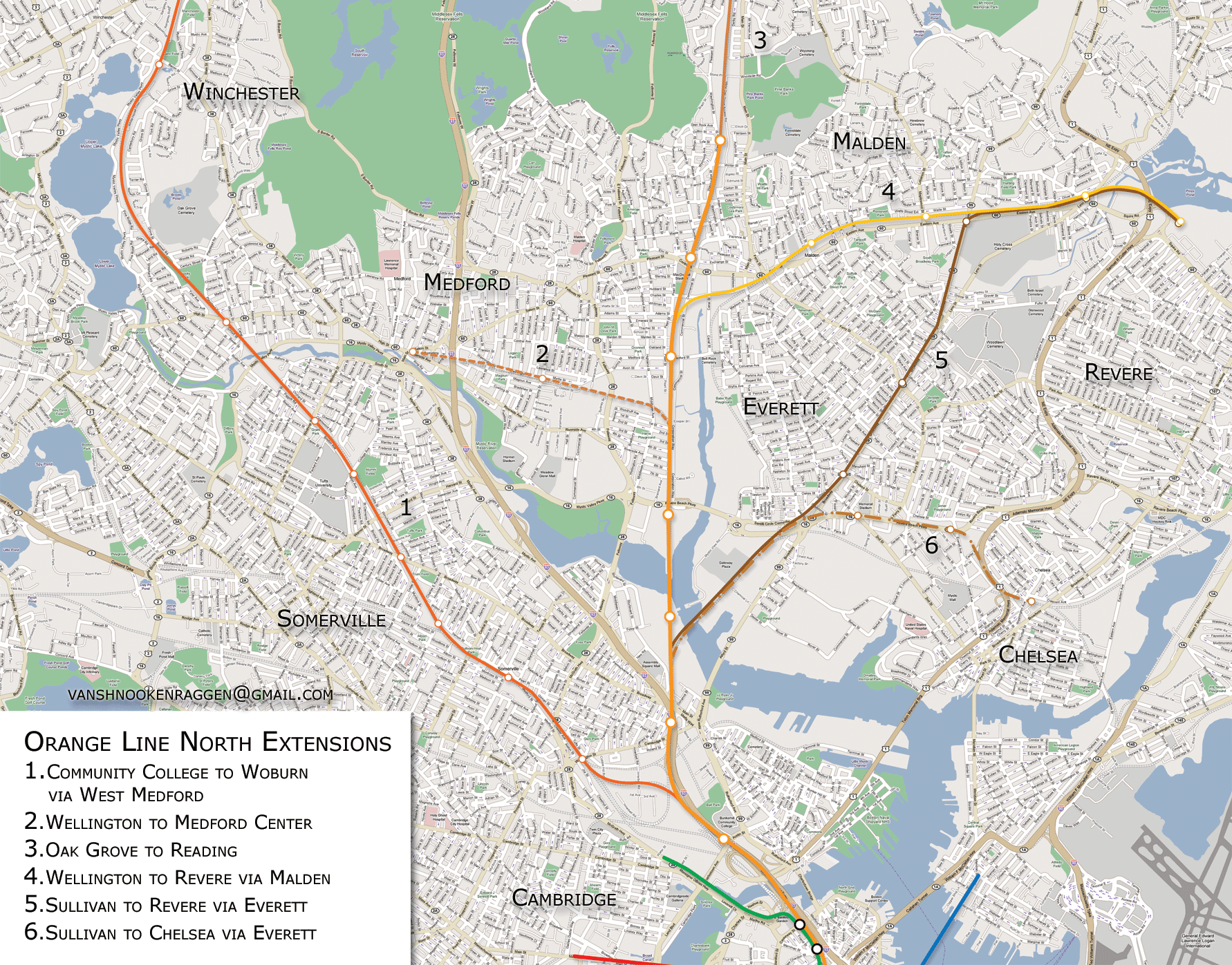
1. Community College to Woburn via West Medford
This proposal is an alternative (though not official) to extending the Green Line to West Medford. The extension would follow the Lowell Commuter Rail line past West Medford to Woburn Center.
2. Wellington to Medford Center
This proposal would create a new branch that would split off the Orange Line past Wellington and follow an abandoned ROW to Medford Center. A major obstacle to this extension is that much of the ROW has been built upon and would be very costly.
3. Oak Grove to Reading
When the Orange Line was originally relocated from the Charlestown El, the plan was to extend it to Route 128 in Reading. However, NIMBYism prevailed and the Orange Line was stopped at Oak Grove and the rest of the route got Commuter Rail. If you look at the line today, you will see a third track that is rarely used from North Station to Wellington. This was to be an express track. If the Orange Line is extended north, the express track should be extended as well. The line would extend along the current commuter rail with an express track.
4. Wellington to Revere via Malden
This extension would use an abandoned ROW which runs through Everett, Malden, and Saugus to Lynn. The extension would only use the area which runs through Malden and terminate at a park-and-ride at Linden Sq to serve Route 1.
5. Sullivan Sq to Revere via Everett
Until the extension to Oak Grove was built in the 1970s the Orange Line ran into Everett across the Mystic River (remnants of an abandoned attempt to extend the Orange Line to Malden in the 1920s.) This extension would retrace the route but continue as a subway into Everett up to Malden, terminating at a park-and-ride at Linden Sq.
6. Sullivan Sq to Chelsea via Everett
This extension would parallel the Newberryport Commuter Rail line into Chelsea or possibly run in a tunnel under the Revere Beach Parkway.
Saugus High Speed Line
Instead of extending the Orange Line all the way out, another idea is to build it a short spur to Linden Sq and a High Speed Trolley Line like the Mattapan Branch of the Red Line. It would start at Liberty Sq. in Lynn at the train station. There it would head along Market St. to City Hall Sq. and go west along the Lynn Commons creating a nice boulevard effect. After that, the tracks would enter a reserved ROW and connect with the abandoned train line. After traveling through Sagus, Malden, and Everett the line would go over the Mystic River and terminate at Sullivan Sq.
theUrbanRing
he Urban Ring is a circular transportation network surrounding Boston. The basic idea is to connect major transit stops, residential areas, commercial areas, and other important destinations by a network of buses, trains, and rapid transit.
This is one of the best ideas out there to improve transit in the Boston area. The problem is that is will be very expensive and, if stated today, wouldn’t be finished until about 2025.
Phase 1
Phase 1 will add new bus Cross-town and Express Commuter bus service to and around Boston. There are currently three Cross-town bus routes, CT 1 from Central Square in Cambridge to the Boston University Medical Center in Roxbury, CT 2 from Sullivan Square to Ruggles via Kendal/MIT, and CT 3 from Longwood Medical Area to Andrew Square via the B.U. Medical Center. Phase 1 routes are being designed to compliment the major bus routes in the area and not act as a supplement to Rapid Transit
Phase 1 would use low floor, articulated buses, the kind that are being used on the Silver Line and on various buss routes like #39 in Jamaica Plain. Stations would be similar to the BRT.
Phase 2
Phase 2 will add more bus routes and some Commuter Rail stations. The primary purpose of Phase 2 is to connect major transit hubs. Phase 2 will use real Bus Rapid Transit and be more like transit stations than bus stops, and some routes will use dedicated bus ways. Phase 2 is being designed to compliment Phase 3 which will be a new Rapid Transit line.
Phase 2 lines will connect JFK/Mass, Dudley Square, Ruggles, Longwood Medical Area, Kenmore Square, Cambridge/MIT, Lechmere, Union Square, Sullivan Square, Wellington, Everett, Chelsea, and Logan Airport. Phase 2 will use low floor, articulated buses like the Silver Line but the stations would be simpler to Silver Line stations.
Phase 3
Phase 3 will be a new Rapid Transit line from Sullivan Square to Lechmere, Kendal, MIT, Kenmore, Longwood, Ruggles, and Dudley Square using light rail or heavy rail like the Orange Line. Heavy rail would be better for a line that would see so much use, and it could use the car shops for the Orange Line at Wellington to help cut costs.
What the Urban Ring could be
The T seems to have a sexual fixation with the idea of BRT. Now, I don’t really have anything against BRT, it’s just, if you are gonna spend billions of dollars, try to build something that will last. I think that the Urban Ring should have two subway routes rather than one. One route will come close to the city and the other will be further out, near Harvard.
The first route is basically what the MBTA proposes, but will connect to Logan rather stopping at Sullivan. It will go from Logan Airport, connect with the Blue Line at Wood Island, follow the Grand Junction RR in Chelsea and Everett, and cross the Mystic to Sullivan Sq. Then it heads south to Lechmere and Kendall. After Kendall it will follow the Grand Junction a bit further and dive under the Charles River to Kenmore Sq. It will travel under Brookline Ave to the Longwood Medical Area where it will make a sharp turn west to Huntington Ave and Ruggles. Here it will head southwest to Dudley Sq, over to Uphams Corner, the current JFK/UMass stop (which will have its name changed back to Columbia, or Expo Center) and finally out to UMass Boston.
The second line will leave from Medford Center, heading west were it will meet up and run parallel with the Orange Line to Sullivan Sq. Here it will sharply turn east and meet up with the two branches of the Green Line on Washington St and Union Sq in Somerville. It will head southeast to Inman Sq in Cambridge where it will make another sharp turn to the east and head to Harvard Sq. At Harvard it will travel under to Charles over to Allston where Harvard University is building its huge student campus. The line will head south under Franklin St, connect with a new Allston commuter rail stop where the Sports Depot is and continue under Harvard Ave, stopping at Comm. Ave and Coolidge Corner. At Coolidge Corner the line will head west and connect with the first line in the Longwood Medical Area.
Green Line Urban Ring
The Urban Ring is a transit plan put out by the MBTA to connect all the transit lines (subway, bus, and commuter rail) that come into downtown Boston with a ring of transit. The purpose of this is two fold; the first being to take pressure off of the 4 major downtown transfer points (Park, State, Gov’t Center, and DTX), and second to connect large job centers, primarily Kendall Sq and the Longwood Medical Area. The current plan is a three phase process starting with improved crosstown bus service, then moving to Bus Rapid Transit -BRT- (e.g. Silver Line), and finally constructing a subway line either using Orange Line heavy rail or Green Line light rail.
The idea for an urban ring is not new. The first instance of a transit line encircling Boston was put out by Robert Gourlay, a Scottish writer and urbanist. When he first came to the young United States in 1817 he realized that the new nation would be building many new cities and that there had to be a scientific way to do so. He began crafting ideas for cities, making him one of the first urban planners. In his “General Plan, for enlarging and Improving the City of Boston”, Gourlay proposed something completely radical: fill in the Back Bay and line the Charles River with a park and train line. He also proposed connecting the Providence, Boston & Worcester, and Fitchburg train terminals with underground tunnels (we don’t have this either). Nothing came of Gourlay’s plan, though he must have planted a few seeds in the minds of Bostonians.
(I mean to have an image of Gourlay’s plan, but I can’t find it online. You can see it in the book “Inventing the Charles River” by Karl Haglund)
The problem most people have with the current plan is that it doesn’t serve enough areas and that it relies mainly on slow moving buses in mixed traffic. I do want to go on record saying that I am all for improved crosstown bus
service, but I am not for relying completely on buses. I do believe that any serious transit plan needs to take them into account and to propose ideas that would improve bus traffic (dedicated lanes), but in the end any urban ring proposal needs to center around an actual subway line. Here is my proposal:
To start with, this is not just a proposal for the urban ring, but it is a fundamental rethinking of how the Green Line would operate.
What this map shows is a series of rings formed by connecting the ends of the Green Line through Cambridge and Boston. The Green Line as we know it today would function as half of the ring while the other half could go through Harvard and Allston (#1) or Kendall Sq (#2). Since the southern end of the Green Line has multiple branches, this gives us more options for where to connect the ring. The first connection would be to Kenmore Sq (#3), either directly under the Charles River or by a new tunnel under Comm. Ave. The next possibility would be under Huntington Ave (#4), connecting Longwood into the ring. The last option would be the most dramatic, connecting the ring to Dudley Sq (#5) where a new tunnel under Washington St would connect the ring into downtown.
What would happen to the trolley service we have now is this:
– B Line would be placed in a tunnel to Brighton where it could terminate or continue to Boston College.
– C Line would cease going to North Station, but would instead travel to South Boston via a new tunnel under Essex St (what Silver Line Phase III is planning on building).
– D Line would connect to the Huntington Ave subway and shuttle service would be instituted along the stretch of track connecting Brookline with Kenmore Sq.
– E Line would be truncated or switched to Washington St tunnel.
If two of the connections were built, then this would give the T much more room to try different services and to reroute trains if one becomes disabled.
The next phase would be to connect the northeastern suburbs.
Unlike the first phase, these lines would only feed into the new urban ring tunnels, not the Green Line tunnels.
The three options as thus: Construct a new line, both in tunnel and at grade, to connect Lechmere with Everett, Chelsea, and Logan Airport (#1). This proposal is currently in the long term plans for the actual Urban Ring but only as BRT. The next would be to use the under-used Saugus Branch ROW that runs along Everett to Malden and Saugus before terminating in Lynn (#2). Service here could terminate at a Park-&-Ride facility at the interchange at Route 1 or continue to Saugus and Lynn. The last options is a line through Charlestown in a tunnel to Chelsea and on to Revere (#3). This would be the most expensive since express bus service covers this basic route today, but I just threw it in there anyway.
This is no simple plan and will most certainly cost billions of dollars. But if you only think about it in terms of how much it’s going to cost you, then you aren’t seeing the forest for the trees. The Green Line today is a relic of Victorian era transportation, and it is evident every time you ride it. Installing a brand-new artery that doesn’t funnel people in and out of the city twice a day but circulates them throughout the business areas, residential areas, and entertainment areas will completely change the way people think about living in the city.
The problem with the current plan for the Urban Ring is that it still clings to the transportation theories of the mid 20th century where people come in from the suburbs at 8am and then leave at 5pm. While there will always be commuting into the city, the city cannot grow and prosper when this is the only option. We need a new way of thinking about how mass transit can strengthen a city and I think that these proposals are a good first step.
theSilverLine
In the beginning, there was BERy, or Boston Elevated Railroad. From around where today is the New England Medical Center rose out of the central subway, the Orange Line. The Orange Line originally went along Washington St., through Dudley Square, and on to Forest Hills, on elevated track. If you have been to New York or Chicago, it looked like that. It only made a few stops (Dover, Northampton, Dudley, Egleston, Green, and Forest Hills). This elevated track was loud, dirty, and unsightly. There had been plans for a while to tear it down, but the problem was where to reroute the Orange Line.
In the 1970s there was supposed to be a freeway built right through Roxbury. Buildings were demolished but after intense opposition to the freeway, it was scrapped. What was left was a nice, free, open path to reroute the Orange Line. It even ended at Forest Hills! So in the early 1980’s the Orange Line as it is today was built. Then in 1987 the old elevated track came down and Washington St. could breathe again. But that was just the beginning.
After the Orange Line came down, the MBTA promised to replace the elevated rail with “equal or better service”. A bus line, #49, was installed to temporarily fix the transit situation. Now here comes the fun part. The people of the South End, whom the new Orange Line route most avoided, decided to replace the elevated rail with light rail running down to Dudley and possibly beyond. What made this an even better idea was that there was an abandoned spur from the Green Line that ran from Boylston to Tremont St in the South End that was covered up by a park. Simple right? Wrong.
The MBTA decided to go above the community and try something called Bus Rapid Transit. This is basically a bus that runs in its own dedicated lane. After years, 15 to be exact, the MBTA finally installed the first phase of the Silver Line from Dudley to downtown. The full plan is for it to go underground near Boylston, in a tunnel and then over to Chinatown, and South Station where it will link up with phase 2 (which is currently being built) that runs underground from South Station, to the Federal Courthouse, and then over to the World Trade Center. It will then come above ground, head over to the new Boston Convention Center, then through the Ted Williams Tunnel to Logan Airport.
First off, that tunnel where the bus will enter to Boylston already exists. The MBTA wants to dig it up and build a new tunnel! Not only that, but the new tunnel will require digging up a large part of Boston Common for the bus to turn around in. Light Rail would be better here because 1) it already has a perfectly good tunnel to use, and 2) it doesn’t require a huge amount of room to turn in.
Secondly, the whole bus over bail thing is, in my humble opinion, pure transit racism. The section of Boston that the Silver Line runs through is the most heavily populated area of the city, and one of the most racially diverse.
Thirdly, the new buses will burn Compressed Natural Gas.& That is great for the environment, but 100% electric light rail would be even better (yes, even though the power will probably come from a polluting power plant). Fourthly, the whole idea of Bus Rapid Transit is that it is just like rail, only with tires! BRT became notable because poorer cities that boomed needed a cheap and effective public transit program. Buses worked great for them, but we are not poor….well, not that poor in relation to those cities. We in Boston have a great history of light rail…and unfortunately a great history of replacing it with buses.
These are just a few of the problems with BRT and the Silver Line. The hard fact is that the Silver Line SHOULD be light rail. The MBTA says that it is designing it so that one day it could be upgraded. But wouldn’t it be cheaper just to build a full light rail system in the first place?
Silver Line Phase II
Silver Line Phase II opened December 17th 2004 and is the newest subway line to open in Boston since the Orange Line relocation in 1987. It starts at South Station above the Red Line and below the newly finished concourse. This means that construction at South Station is FINALLY over (I lived in Boston for 6 years and South Station was one of the first places I went to, and back then it was nothing but concrete blocks). New tiles and a refurbished “South Station Under” sign found under layers of old renovations finally gives the station some respect, however the Red Line platforms are still covered in black soot.
After a short drive (really long because the buses aren’t on a track, so the drivers can only go about 15 mph) you get to Courthouse station. This is the jewel of the system. The platform level is interesting because the is no fence between the bus ways, just storage space. When you go up the escalators you get to the main concourse which is this beautiful silver and purple “room”. Interestingly there is no free crossover, but this was probably done because of intended foot traffic crossing under New Congress St once the South Boston Waterfront becomes developed with commercial, hotels, and residences. An interesting fact is that the walls are all designed so that adds can be projected on them digitally (think Times Square in a subway station).
The last underground station is World Trade Center. This station has been finished for the longest out of the three. At the top a stairway/elevator connect to the elevated road and is only a few hundred yards from the Boston Convention and Entertainment Center. Right after this station, the buses ascend to the surface and cross at D St. This is probably the only really stupid thing in the otherwise well-designed Silver Line Phase II. The buses have to wait at a traffic light to cross, but there is no software telling the light to let the buses go when they come up.
After WTC the buses go under the Manulife building to Silver Line Way (name of the “station” and road). This station is no more than a large bus stop, but what happens when the buses get here is the cool feature of the Silver Line. The buses convert from using electricity through overhead wires and go to diesel. From here the buses go to Black Falcon Pier, City Point, and Logan Airport.
Future Extension
Plans call for the extension south of the Silver Line from Dudley to Grove Hall and then to Mattapan and Ashmont. This is a great idea, seeing that that is a huge area of Boston not served by Rapid Transit. Because it is a bus, it would be cheap and easy.
More ideas are that the Silver Line could be extended west to Kenmore and then branch off to Brighton and Longwood Medical Area. This, to me, is somewhat stupid. The Green Line already serves this area and having 60 foot buses running through the streets of Boston in mixed traffic would almost certainly go against one of the basic principles of BRT.
Back Bay Tunnel
However, long range transit plans for Boston do require that a new subway tunnel be built through Back Bay. The original plans for the Silver Line were for it to connect to the Green Line at Boylston St so people could get to the offices, Hynes Convention Center, and hotels of the Back Bay. A new tunnel from Boylston to Kenmore along Stewart St and then the Mass Pike would connect the two areas while alleviating traffic on the Green Line.
An idea I whipped up would that the D line be changed to the Silver Line. The line would follow the normal D line route and could have a spur to Needham which is being talked about in Upper Falls in Newton (see map). This would then allow the commuter rail to go to Millis instead of making a new branch off the Needham line. Another Silver Line branch could follow the Mass Pike through Newton and meet up at Riverside, forming a loop. This would serve more people and take pressure off the Green Line.
Because the tunnel would be light rail, no new upgrades would need to be done for a converted D line (besides any branches). By taking traffic out of the Green Line the Washington St section of the Silver Line could then be converted to light rail and run into the central subway. Also, more trains could run for the remaining B, C, and E lines. This would then make it easier to extend the Green Line to Union Sq in Somerville and West Medford or a restored A line to Oak Sq in Brighton.
theCommunterRail
By Joshua Bellin, Cambridge, MA
Chelsea, Everett, Somerville, Dorchester, Allston, Brighton, Belmont, Waltham – all these communities, which are under served by rapid transit, share one thing in common: Commuter Rail lines running through them. For some, like Everett, Allston, Brighton, and Somerville, the Commuter Rail makes no stops. For others, such as Dorchester, Belmont, and Chelsea, the Commuter Rail does indeed stop, although with its limited service, it is far from a true rapid transit option. Besides, these are not bedroom communities with commuters only seeking to arrive and depart North Station or South Station.
These are inner suburbs, with inhabitants who live urban lives, and who therefore have a need for a flexible rapid transit option that connects them not only to the financial district, but to other rapid transit lines and other neighborhoods as well. With the MBTA’s radial spoke-and-wheel system, which limits all connections to a few stops downtown, this is a fact that is well-recognized, and has led to the planning stages of a so-called Urban Ring rapid transit line.
We will return to the concept of the Urban Ring later. For now, let us briefly explore the possibilities of introducing rapid transit onto Commuter Rail lines. FRA regulations prohibit light rail vehicles sharing track with freight and Commuter Rail trains, and yet Commuter Rail trains themselves, with their push and pull locomotives and their slow acceleration and deceleration, are particularly unsuited for stop-and-start rapid transit.
Enter DMUs – Diesel Multiple Units – trains in which each car has its own diesel engine, allowing the unit to easily make start-and-stop trips. Without any locomotive car, DMUs, which can be ADA-accessible, are very much akin to heavy rail or LRV subway cars, able to act much as the D-Riverside Green Line does, although able to share tracks with fright and Commuter Rail trains.
DMUs are at the center of many proposals for the “Indigo Line” – a rapid transit alternative to the long-neglected Fairmount Line of the Commuter Rail which runs through Dorchester, a densely populated neighborhood which is criminally under served by rapid transit. There, Commuter Rail tracks need to be maintained, since they are the only alternative route into Boston from the southwest. They could, however, be serviced by DMUs fully integrated into the MBTA rapid transit system. As the cost of adding a new rapid transit line goes, the Indigo Line is a bargain: new rolling stock, and new and improved stations. No new tunnels, and a minimal investment in new track, if needed.
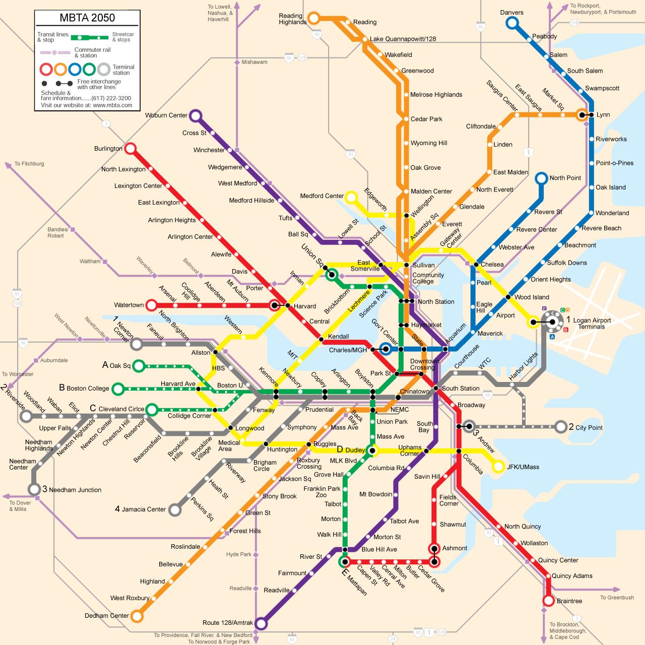
The MBTA and its Future Extensions
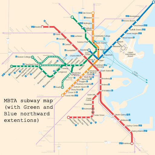
This map illustrates the MBTA rapid transit lines, with two additions. First, the Green Line is extended north from Lechmere through Somerville to West Medford. This is an extension that is likely to occur, and is an important component of this proposal. New plans indicate a spur on this line into Union Square – an expensive addition. With this proposal, such a spur is unnecessary, and Union Square is serviced by a much more cost-efficient option.
The other change illustrated is the Blue Line extended north, possibly to Lynn. This extension is on these maps in order to show future possibilities, although it is not a necessary part of this proposal.
The Indigo Line, Writ Large
This proposal calls for two new DMU rapid transit lines integrated into the MBTA system, running on existing track shared with the Commuter Rail.
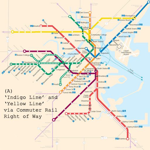
As illustrated in MAP A, one line runs from Dorchester – the Indigo Line – to both South Station and, (since through-service through South Station is impossible) along a continuing track bypassing South Station and continuing along the Worcester Commuter Rail line which parallels the Massachusetts Turnpike. This section of the line begins in Newton – either Newton Corner or Newtonville, whichever allows the construction of an end-station most efficiently, and stops along the Commuter Rail tracks at Nonantum, where the tracks cross Brooks Street, North Brighton where the tracks cross Market Street, and Allston at the current site of the Sports Depot, where the tracks cross Franklin Street (the short extension of Harvard Ave after Cambridge Street). It will then stop at Boston University, at the BU Bridge, and then not far from Kenmore, where a pedestrian walkway will allow transfers to the Green Line (B, C, and D). It will then stop at Prudential, connecting to the E line, followed by Back Bay station, connecting to the Orange Line, and where the Commuter Rail will continue to stop. Before South Station, it can make one more stop near the New England Medical Center, at Tremont Street. The line will then split: one spur going to South Station, and the other one continuing along the aforementioned track through Dorchester.
Besides the relatively inexpensive cost of a completely new rapid transit line, benefits of the extended Indigo Line include:
a) Environmental justice for communities including Dorchester and Allston/Brighton, the latter of which used to have the A Line of the Green Line.
b) Relieve congestion on the Green Line by providing an express alternative from Kenmore to the Back Bay and South Station.
c) Relieve congestion at Park Street station by allowing an earlier connection from the Green Line (all lines) to South Station.
d) Specifically relieve congestion on the B Line by providing an express service to BU and Allston.
e) Expand possibilities for “Urban Ring”-like transit by connecting to all lines (except the Blue Line) outside the Financial District.
The Yellow Line, especially its western section from Brandeis-Roberts to North Station, is conceived as a north-of-the-Charles version through Waltham, Belmont, Cambridge and Somerville of what the D-Riverside line is through Newton, Brookline, and the Longwood/Fenway neighborhood. Waltham, the furthest destination of the DMU lines, is a sensible endpoint. Not only is it a densely-populated city with few rapid transit options and a need for environmental justice, but, with its educational institutions and large I-95/Rt 128 employers, it is also currently one of the prime destinations for reverse-commuters on the Commuter Rail. Brandeis-Roberts, with its close proximity to I-95/Rt 128, leaves open the possibility of a Riverside-like parking garage and terminus for commuters adjacent to the circumferential highway.
The line will service all current Commuter Rail stops, including Waltham Center, Waverly, Belmont, and Porter Square, and may make new, additional stops between these. The Commuter Rail may no longer need to stop at all stations, such as Waltham, Waverly and Belmont, thus increasing its speed for Fitchburg Line commuters. (It should, however, still stop at Brandeis-Roberts and Porter.) After Porter, it will stop just south of Union Square in Somerville, a station currently (and, according to this proposal, needlessly) envisioned as an expensive spur on the extended Green Line. It will then connect to the extended Green Line at Twin City Plaza, a stop not currently slated for the Green Line extension. After Twin City, the line will terminate at North Station.
On the eastern side, the line begins on Commuter Rail track near Wonderland, currently also the terminus of the Blue Line. It will serve the communities of Chelsea and Everett, and the current Commuter Rail stop at Chelsea can be eliminated, increasing the speed of the Commuter Rail journey. The line connects to the Orange Line at Sullivan Square, and also terminates at North Station. Since there can be no through-service through North Station, the line may, at peak or off-peak times, run trains directly from Wonderland to Waltham, on connecting track that avoids North Station.
Besides the relatively inexpensive cost of a completely new rapid transit line, the benefits of the Yellow Line include:
a) Environmental justice for communities of Chelsea, Everett, Somerville and Waltham. Everett in particular would have rapid transit service for the first time since the Orange Line “El” was closed in 1975.
b) Expand possibilities for “Urban Ring”-like transit by connecting to all northern lines outside of Boston.
c) Maintain a direct link between the historically-connected cities of Somerville and Cambridge, which the Green Line extension alone would not maintain.
d) Relieve congestion on the Red Line and at Park Street and Downtown Crossing by providing Cambridge residents with direct service to North Station as well as more generally an alternative route downtown.
e) Relieve congestion of the Blue Line and at State and Government Center by providing Revere residents with direct service to North Station as well as the alternative route downtown.
Expansion on Unused or Underutilized Track
The MBTA system can be further expanded not only by utilizing Commuter Rail lines for rapid transit, but also by using unused or underutilized track. MAP B suggests two potential expansion spurs along such track: first, a spur from the Yellow Line through the Fresh Pond/Mount Auburn area to Watertown (the tracks terminate at Arsenal, unless the tracks are extended a short distance to service Watertown Square), and a Green Line spur from the D-Riverside Line to Needham along a busy and congested corridor in Newton Upper Falls.
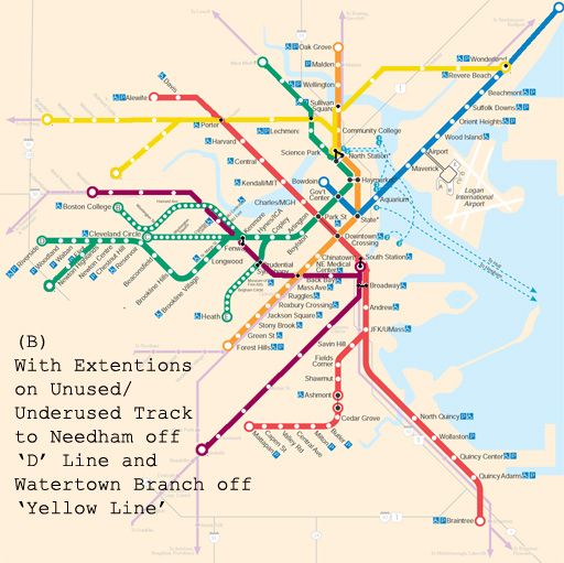
These potential extensions are meant to highlight the potential for rapid transit along existing track, and are not as essential to the main proposal of running DMUs along existing major rail corridors.
A Nice Ring to It: The Harvard Connector
Of more direct value to the system itself would be a spur on the Indigo Line between BU and Allston to Harvard Square through North Allston, as illustrated in MAP C. Trains can then run along five different routes:
Newton-Harvard and vice versa
Newton-Dorchester and vice versa
Harvard-Dorchester and vice versa
Newton-South Station and vice versa
Dorchester-South Station and vice versa
Direct Indigo Line service between Harvard and South Station is also a possibility, although it would be redundant given the direct Red Line connection between the stations.
Unlike the rest of the proposed Indigo and Yellow lines, the “Harvard Connector” on the Indigo Line would require new track, most likely a new tunnel, and a new Charles River crossing – an expensive undertaking, which in the post-“Big Dig” world of Massachusetts politics might seem impossible. However, there are several reason why this project in particular might be fiscally and logistically viable.
Harvard University – one of the country’s wealthiest private institutions – is expanding its core campus into North Allston through an ambitious building project. According to Harvard planners themselves, public transportation into the area is a major concern. Additionally, given Harvard’s emphasis on being a “good neighbor,” transportation in a revitalized North Allston is not just an issue for the university, but for residents as well.
Fortunately, Harvard also owns all of the land from the Allston train yard, directly south of which is the Commuter Rail line, to the Charles River, including an industrial area between the train yard and Western Ave, which Harvard eyes for future expansion. Rail connections exist from the Commuter Rail track alongside the rail yard next to Cambridge Street into this industrial area. This connection is illustrated on the map below in pink, and an alternative entry into the industrial area is indicated in blue. The white triangle delineates the ideal location for a North Allston stop, and the pink circle pinpoints the location of the proposed Allston stop.
The Indigo Line could therefore run on the surface from the Commuter Rail tracks all the way into North Allston. Alternatively, many of Harvard’s proposals for North Allston include new road connections, and a cut-and-cover tunnel under a new road might also be a possibility.
With regards to crossing the Charles, Harvard has envisioned several new crossing options, including tunnels to both the east and west of the current JFK Bridge. For a rail tunnel, it is essential that the tunnel be west of the bridge, since this would make a connection into Harvard Square far less expensive. An abandoned tunnel currently stretches from Harvard Square south to the JFK School of Government (on the west side of JFK Street) and this is the tunnel which can serve the Indigo Line into the Square, where passengers can connect to the Red Line.
While still an expensive proposition, the Harvard Connector would nonetheless have several important circumstances working in its favor. First, its construction would intersect with Harvard’s interests and even its future plans for construction in the area, meaning that Harvard may be convinced to provide a degree of funding to the project, not to mention land; second, the line can make use of existing track adjacent to the train yard bringing the rail line into North Allston; and third, linking the connector into Harvard Square can make use of existing abandoned tunnels north of the Charles. Compared to other proposed rail tunnel projects, therefore, this would not be the North-South rail link, or the Blue-Red Line connector.
It should be noted at this point that even without the Harvard Connector, the DMU lines would provide enough benefits – both in bringing service to under served areas and in providing “Urban Ring”-like transit connections – to more than justify its relatively inexpensive cost.
The Harvard Connector would firmly enhance the Urban Ring properties of the DMU lines. Looking at MAP C, one can visualize its potential for engendering transfers outside of downtown. More specifically, it would:
a) Relieve congestion on the Green Line between Kenmore and Park, the Red Line between Park and Harvard, and Park Street station itself by creating an earlier connection to Harvard for all points west on the Green Line.
b) Relieve congestion on the Route 66 bus by providing a direct connection between Harvard and North Allston and Allston/Brighton, as well as by providing a quicker connection to all points on the Orange Line including Roxbury Crossing, via Back Bay Station.
c) Integrate the contiguous academic area stretching from BU to Harvard with the latter’s expansion southward.
d) Integrate Harvard with both its Longwood medical campus, as well as the New England Medical Center.
e) Ensure transportation options in a revitalized North Allston, and reconnect the Allston area, which has been fractured and divided since the Massachusetts Turnpike Extension.
The Union Square Extension
While the Harvard Connector may, for reasons previously explained, be a feasible part of this larger DMU proposal, an extension to Union Square via Inman Square as illustrated in MAP D – while consummating the idea of the DMU lines as an Urban Ring – would probably be prohibitively expensive and generally infeasible. If completed, however, it would, raise the possibility of integrating the two DMU lines and effectively creating an Urban Ring transit line from Wonderland to Dorchester via Chelsea, Everett, Somerville, Cambridge, Allston, Kenmore, and the Back Bay/South End. If the expense of an Urban Ring rail line is to be undertaken anyway, this option should be considered as an alternative.
Conclusion
DMUs along existing Commuter Rail lines is a feasible and inexpensive means of adding two new lines to Boston’s rapid transit system, thereby both bringing service to currently under served communities, and facilitating “Urban-Ring” like transit connections outside the Financial District. With the potentially feasible Harvard Connector, this latter property of the new lines can be more fully realized, and would provide very real benefits to the transit system overall, despite not being as complete as with the more costly Union Square connector
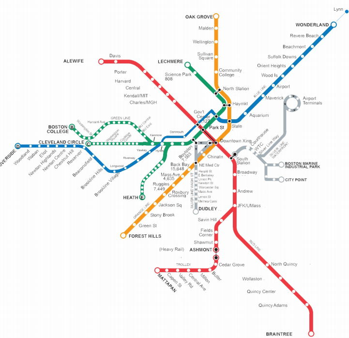
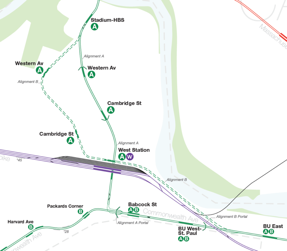
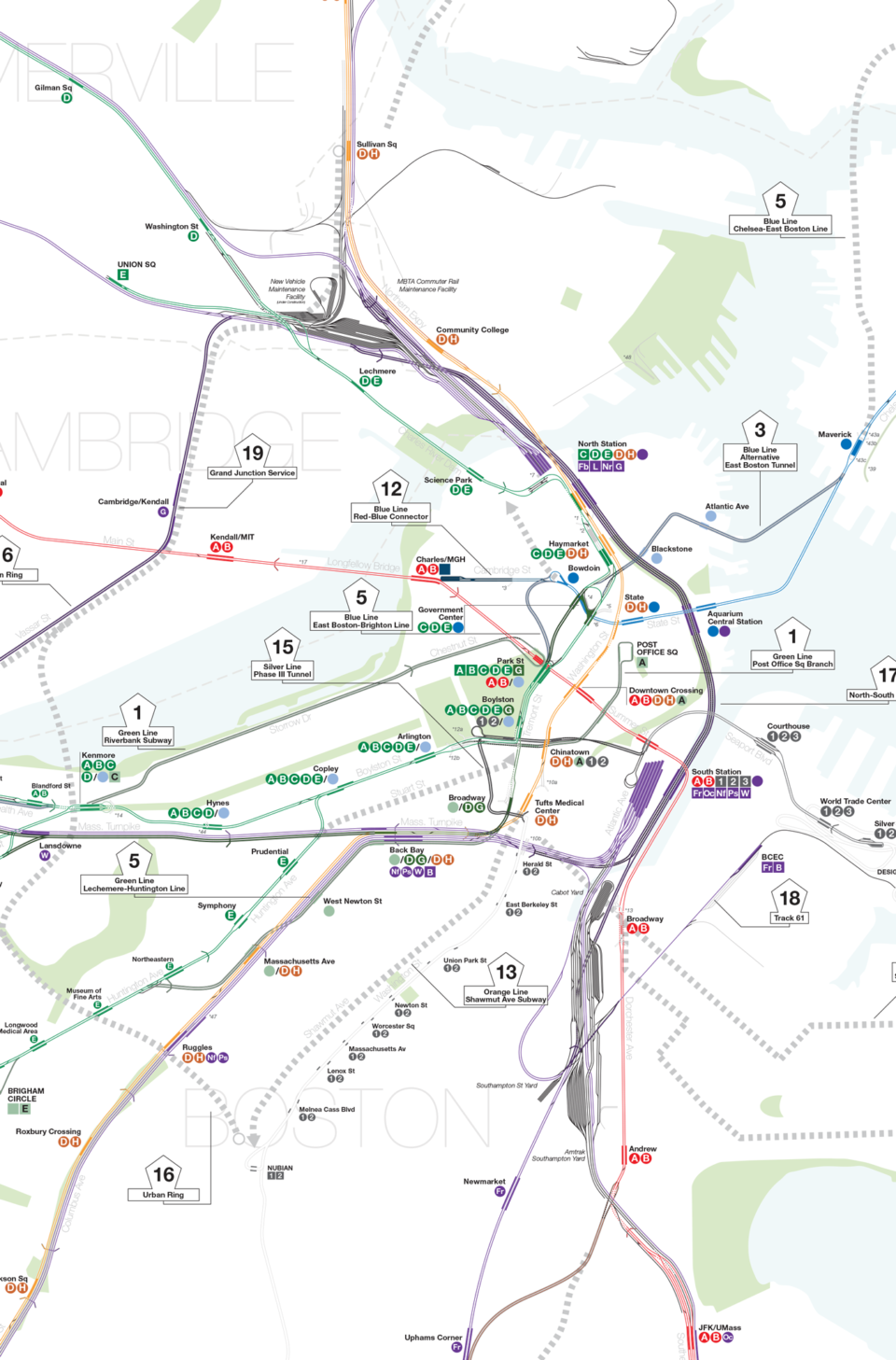
How did you make three maps?
I live in New York City and I have a few questions about the layout of the Boston MBTA.
1. Why are there a lot of loop terminals?
2. Why when there are express tracks they are positioned 🔽🔼🔽🔼 as opposed to NYC where they positioned 🔽🔽🔼🔼?
3. Why when a line branches, there are a lot of places that they go across the tracks instead of over or under the tracks?
4. How is it possible that there could be 4 lines on one track?
The core thing you have to understand is that the Green Line is completely different than NYCT. In fact NYCT is pretty unique world wide so you can’t really base others on it as a model.
Loop terminals date from when street cars only had one divers seat. Unlike today, where a train set has one at each end and the conductor can just walk to the other end to turn the train, back then conductors could only “turn” the trains via a loop. Trains have changed but the loops remained mostly because they worked well enough and it was expensive to rebuild them. But no new loops will be built.
The Green Line has 4 tracks but these are not express/local like in NYC. Rather they were simply to separate the traffic headed west along Boylston and south along Tremont (the latter being abandoned). Today only half the capacity is being used they mostly just use the center tracks for turning trains.
Grade crossing: the Green Line as we know it today was once a much more complex network of street cars. In fact the first subway wasn’t really designed as “mass transit” as we know it and rather as just a way to take all of the street car traffic and put it underground. It was only later on where many lines were replaced by buses that the more mass transit nature emerged. So all the grade crossings kind of made sense. I mean, they still knew better at the time since they did build a couple flying junctions! But the unfortunate short answer is they did grade crossings because they were cheap. It’s a problem holding the system back.
Light rail train sets are significantly shorter than heavy rail (even in Boston) so the number of trains on a track can be higher. Think of it like a street with a high number of bus lines. As long as the buses are moving you can have any number of “branches”. But, as you can probably imagine, this does restrict frequency on the branches themselves, though, not really as bad as if it was heavy rail. And the branches themselves have much lower ridership than the trunk. Think of the BART in San Francisco as a similar system but with heavy rail. In fact, one thing Boston has always done better than NYC is a feeder network of buses and light rail fanning out from a subway stop. This way most areas always have a two seat ride to the core. Most stations have bus loops (many used to be trolley loops) to make the transfer more seamless. The Green Line was just left over from that.
None of this is to totally defend the Green Line. It’s a legacy system which has be inelegantly upgraded over the last century.
This is really awesome, great work! As a UMB student I think its necessary to move the JFK/UMASS station to actually be at the school and not a half mile away especially considering the massive amount that university does for the community. However, we need expansion in the entire MBTA system as it is more sustainable and safe than cars
A subway line or more commuter rail lines to Dedham Center and Oakdale would be a lifesaver
Extension of the green line from Newton Highlands to downtown Needham would provide increased transit to accommodate individuals to access downtown Boston conveniently and more frequently compared to the commuter rail service. Also direct service to Fenway Park, Celtics & Bruins games.
I’m glad to see the short Harvard-Watertown line pictured on the map, but I think it could be expended to be a more useful line. Starting in Central Square, Waltham, the line could follow Main Street to Watertown Square, then Arsenal Street and Western Avenue, This line would service Genzyme, the Harvard Business School, the to-be-constructed science campus, Brighton Mills, Watertown Mall, Arsenal Yards and Waltham Center. Beyond Central, the line could follow Prospect Street to Inman Square and finally Union Square. This would potentially serve many more facilities and riders and greater connectivity to other lines.
The other suggestion is to extend the Blue Line beyond Charles MGH across the river to Cambridge. Beyond Serving Kendall Square, the line could extend to Union Square. From there it could potentially follow the alignment to Waltham outlined above.
One last extension worth thinking about is extending the Mattapan line beyond Ashmont to follow an alignment that eventually meets up with the Braintree branch of the Red Line at an infill station at Neponset. On the other end, the line could be extended from Mattapan to Forest Hills (this was actually a former trolley route.) Route 1 as depicted on the map shouod terminate at Watertown Square instead of Newton Corner. Again, connectivity.
Connectivity is what makes systems like Paris, London and New York great and useful. We have far too little of that in the current system.
I like the way you’re thinking, but I think one small change to the Watertown extension idea could make it easier to get public support. The Red Line communities already have plenty of service, so it would be tough to sell the idea of connecting Watertown with the same line. Instead, you could extend Bowdoin across the river and split it at Central to create a new Blue Line branch. This new branch could run through HBS, Arsenal, and out to Moody Street, giving those areas better access. On top of that, the Blue Line should be extended north to Peabody and Danvers. Waltham and Lynn are good matches as manufacturing hubs, and linking them would probably get people on board.
The Orange Line would be the next easiest to extend if you’re looking for public support. Going south to Hyde Park and Dedham is a no-brainer, but figuring out the north extension is trickier. After Melrose, you’d have to decide whether to loop into Reading or split into Woburn. Either way, one of those areas will feel left out. The Red Line has the same issue with its northwest extension. Arlington seems more open to it now, but once you go through there, you’d have to pick between heading to Lexington or going toward Burlington by Route 3 or Hanscom. Lexington would need to be okay with becoming more of a commuter town, which might not sit well with everyone. Milton in the south is in the same boat, although Arlington seems to have softened its stance since they last shot the idea down.
This lays the groundwork for completing the spider network, but some plans try to push it too far. Instead of endless branches, you could solve the connectivity issue with two subway loops. One would be an inner loop, and the other would be an outer ring. The inner loop would be about 15 miles long and would start at Logan Airport, hit all the terminals, and then go through Chelsea, Everett, Assembly, Union, Central, Fenway, Northeastern, Boston Medical Center, Andrew Square, Broadway and Dorchester, L Street and West 1st, the Leader Bank Pavilion, and then back to the airport. The outer ring would be about 20 miles and would connect places like Lynn, Saugus, Medford Center, Tufts, Alewife, Arsenal, Boston Landing, Boston College, Chestnut Hill, Roslindale, Ashmont, and Neponset.
To tie everything together, you’d also need a commuter rail ring to connect the suburbs and different rail lines. This ring could start in Haverhill, head down to Danvers, follow just outside Route 95 through Framingham and Natick, then pass through Canton and Randolph, Braintree, and New Bedford and Fall River. You’d have to decide whether to include Providence in the loop or not. From there, it could go to Worcester, up to Fitchburg, through Devens, Lowell, and back to Haverhill.
This setup would make a huge difference for eight or nine million people. It would simplify things, make the whole system more connected, and give everyone better access across Greater Boston and beyond.
What about redeveloping Hanscom Field into a massive mixed use development as part of a Red line extension or does its use by the Airforce prevent that? Also, would an elevated extension allow for the preservation of the bike path?
Nothing is possible as long as the Air Force still owns the airport. As for an elevated rail line through Arlington and Lexington, you’re sooner to see pigs fly.