
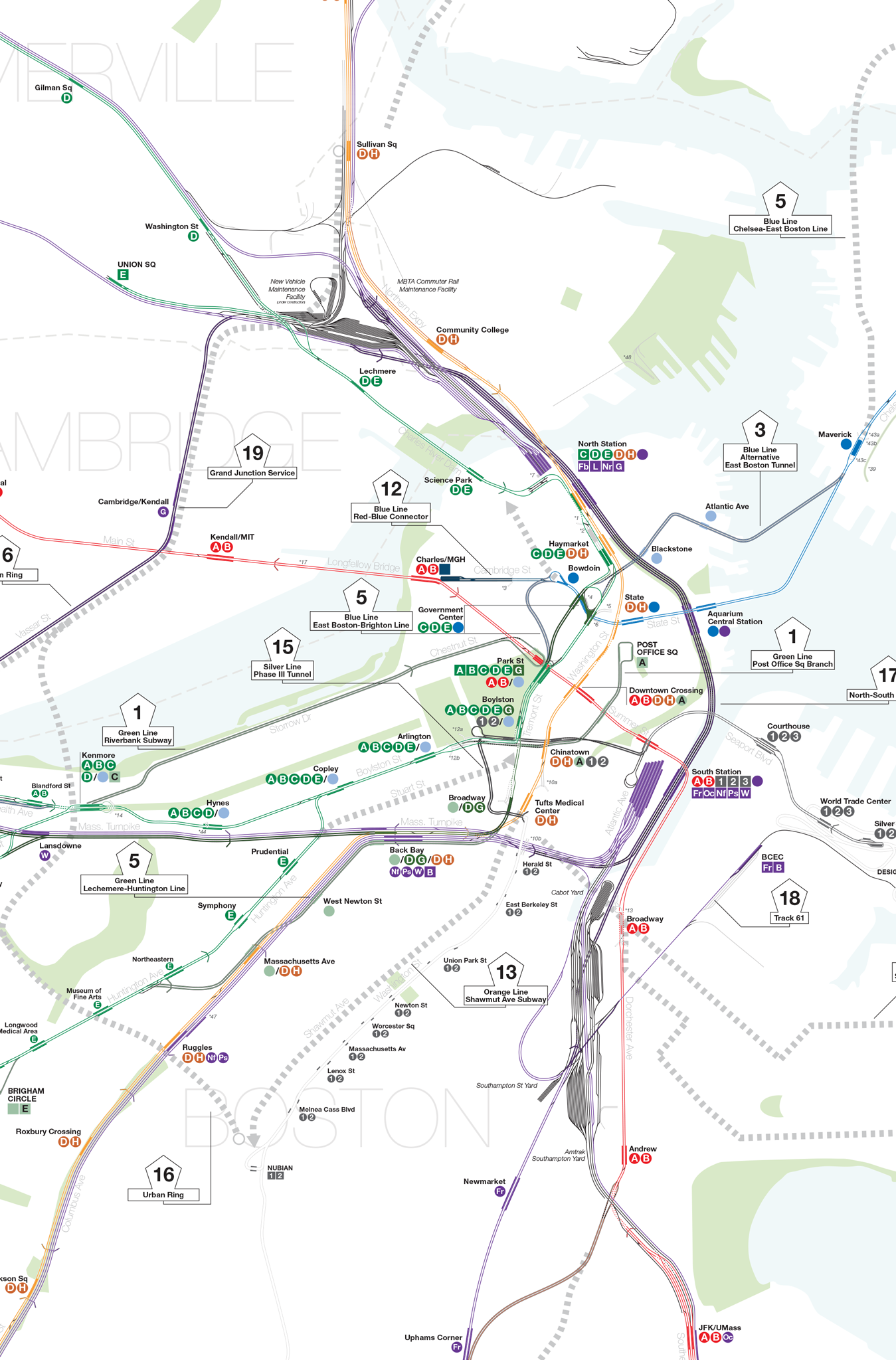
Quick Index
- Green Line Expansion: 1897-1920
- Red Line: 1912-1920
- Blue Line: 1904
- Orange Line: 1901-1920
- Green and Blue Lines: 1920s-30s
- Green Line to Newton and Needham: 1945-1959
- Green Line to West Medford and Woburn: 1945-Present
- Green Line Watertown and Arborway Branches: 1969-2005
- Red Line South Shore Branch: 1945-1980
- Red Line Northwest Extension: 1945-1985
- Blue Line to Wonderland and Lynn: 1945-Present
- Red-Blue Connector: 1970s-Present
- Orange Line Southwest Corridor: 1945-1987
- Orange Line North: 1945-1975
- Silver Line: 2000-Present
- Urban Ring: 1990s-Present
- North-South Rail Link: 1890s-Present
- Track 61: 2010s-Present
- West Station and Grand Junction: 2010s-Present
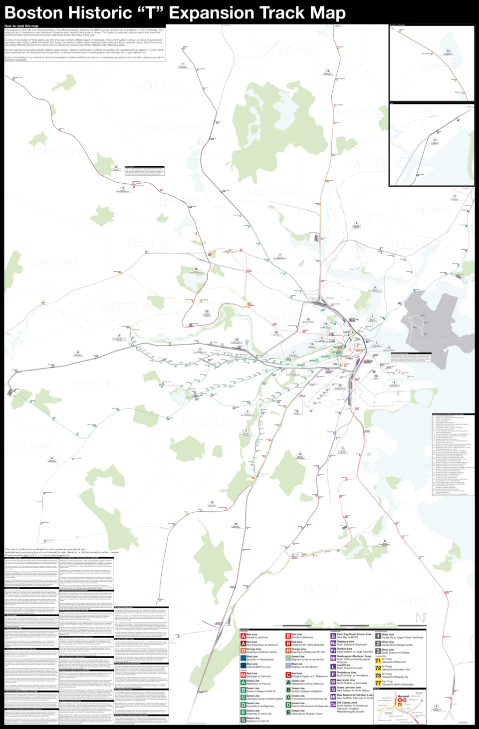
How to read this map
The purpose of this map is to show the history of all official expansion plans for the MBTA subway system from its inception in 1897 until today. The map acts as a “choose your own adventure” where by each variant of every plan is drawn. The reader can pick and choose which lines they think could have been built and what the system might have looked like today if they had.
To show the evolution of these plans over time this map contains different layers of proposals. The current system is drawn as is but proposed lines are drawn with a black outline. Pre-World War II plans are drawn in lighter colors while post-War plans are drawn in darker colors. Some lines show two totally different services at the same time to indicate how service would have differed under alternative plans.

For the majority of proposals specific stations were outlined. Stations which have no official designation are indicated with an asterisk (*). Lines which were proposed but not developed into actual plans, or alternative extensions to existing plans, are indicated with a grey dashed line.
Exact route labeling, if not evident by historical precedent or determined by track layout, is completely speculative and should be viewed as purely for illustrative purposes.
- Green Line Expansion: 1897-1920

What we know today as the Green Line opened in 1897 as the first rapid transit subway in the US and third in the world. The Green Line was designed to take in numerous streetcar lines originating from all over the city and its suburbs and seamlessly terminate them under the streets of Boston.
After the initial success of the Green Line plans were drawn up to expand the network. The two most famous examples from this time period were the Riverbank Subway plan and the Post Office Square branch.
The Riverbank Subway was a mostly above ground line be built from Park St to Kenmore Sq along the banks of the Charles River. At that time Storrow Dr had not been built. The line was to act as an express bypass for streetcars coming from the suburbs of Brighton, Allston and Brookline. No stations were planned on the route and streetcars would have used a large new loop built next to the Park St station.
Boylston St was chosen instead as it was more centrally located. Provisions were added as part of the extension for a possible branch to Post Office Sq. This new branch would have taken pressure off Park St station which was going to be temporarily converted to heavy rail for the new elevated lines, the future Orange Line before the Washington St Tunnel could be built. The plan was dropped as it was felt that the Washington St Tunnel would provide adequate service.
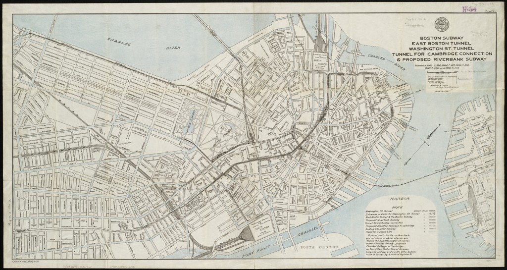
2. Red Line: 1912-1920
The Red Line was first conceived as an elevated line which would have run from Harvard Sq in Cambridge to Maverick Sq in East Boston. But a dispute between the Boston Elevated Railway (BERy), who were building and operating the lines, and the Boston Transit Commission split the line into two different subways. The Cambridge Tunnel opened to Park St Under in 1912. Beginning in 1915 the line was extended to South Station and by 1918 had been extended to Andrew station.
South of Andrew BERy originally considered continuing the line as a traditional subway through Uphams Corner and south along Washington St to Talbot Ave. Instead of building a new subway, BERy chose to purchase the Shawmut Branch Railroad from the NY, New Haven & Hartford Railroad (New Haven Railroad) and convert it to rapid transit. This became the Ashmont and Mattapan Branches.
At the time BERy considered continuing heavy rail through to Mattapan but residents opted for a high-speed trolley instead. BERy considered building a second branch of the Red Line which would run from Andrew station to a new line paralleling the Fairmount Branch railroad to Blue Hill Ave where it would loop back via an ungraded Mattapan Line. With Mattapan staying as a high-speed streetcar this plan was ultimately shelved.
3. Blue Line: 1904

The Blue Line opened in 1904 as the first rapid transit line to run under a body of water. The tunnel was used by streetcars but designed for heavy rail and ran from Court Sq, near Government Center, to Maverick Sq in East Boston. Since it was built for the same streetcars as the Green Line alternative plans were drawn up which would have built the tunnel under an alignment which would have allowed East Boston cars to connect to the Green Line under Scollay Sq (now Government Center). This alternative alignment would have run through the heart of the North End and provided two stations for residents.
4. Orange Line: 1901-1920
The Orange Line started as an elevated train network which featured branches from the South End (Dudley Sq, now Nubian), Charlestown, and a proposed but dropped branch to South Boston. Trains originally ran along the outer tracks of the Green Line subway Pleasant St portal to North Station. A second branch ran along Atlantic Ave to serve the seaport. In 1908 a permanent tunnel for the Orange Line was opened under Washington St and streetcar service was returned to the Green Line.
The Orange Line was soon extended to serve the growing suburbs. In 1909 it was extended from Dudley Sq to Forest Hills. A decade later the northern end was extended from Sullivan Sq to Everett. The terminal in Everett was meant to be temporary and the extension planned to run north along Main St to Malden Center. An elevated line was opposed and the plan was eventually dropped.
5. Green and Blue Lines: 1920s-30s
The Boylston St Subway was originally built to a portal east of Kenmore Sq but traffic in the square delayed streetcars so an underground station was soon proposed. As part of this project planners developed a proposal to convert the whole of the Green and Blue Lines from streetcars to heavy rail and create two new rapid transit lines.
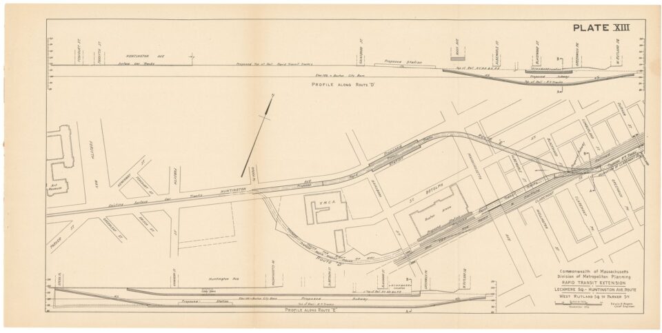
The first route would have run from Lechmere to Brigham Circle. By utilizing the eastern two tracks at Park St the line would run south through Boylston to a new subway tunnel running from the Pleasant St portal to Back Bay station, then along the New Haven RR tracks before swinging west to Huntington Ave. The subway would ascend to the surface, as the E branch does today, and have run southwest along Huntington Ave to a large loop terminal at Tremont St and Brigham Circle.
The second route would have run from Brighton to East Boston. The Blue Line was to make a large curve south from Scollay Sq or Bowdoin stations and connect to the western two tracks at Park St. From here the line would have run west along the existing Boylston St Subway to a new station under Kenmore Sq. After Kenmore the subway was to continue west under Commonwealth Ave to Warren St where a large transfer terminal was to be built (today the Franciscan Children’s Hospital stands in this location). The streetcars from the A and B branches were to terminate here.
In 1924 the Blue Line was converted to heavy rail but was not extended west. Kenmore station was built so that the center two tracks were lower than the outer tracks for a “future conversion” to heavy rail. The portal for the B branch on Commonwealth Ave was built to be temporary for a future extension west.
Plans for a Huntington Ave subway evolved into the 1930s when a final plan for the subway as we know it were finalized in 1933. Funds were provided by the WPA and the two new stations and portal at Gainsborough St were all built to allow for future conversion to heavy rail. The Huntington Ave subway opened in 1941.
6. Green Line to Newton and Needham: 1945-1959
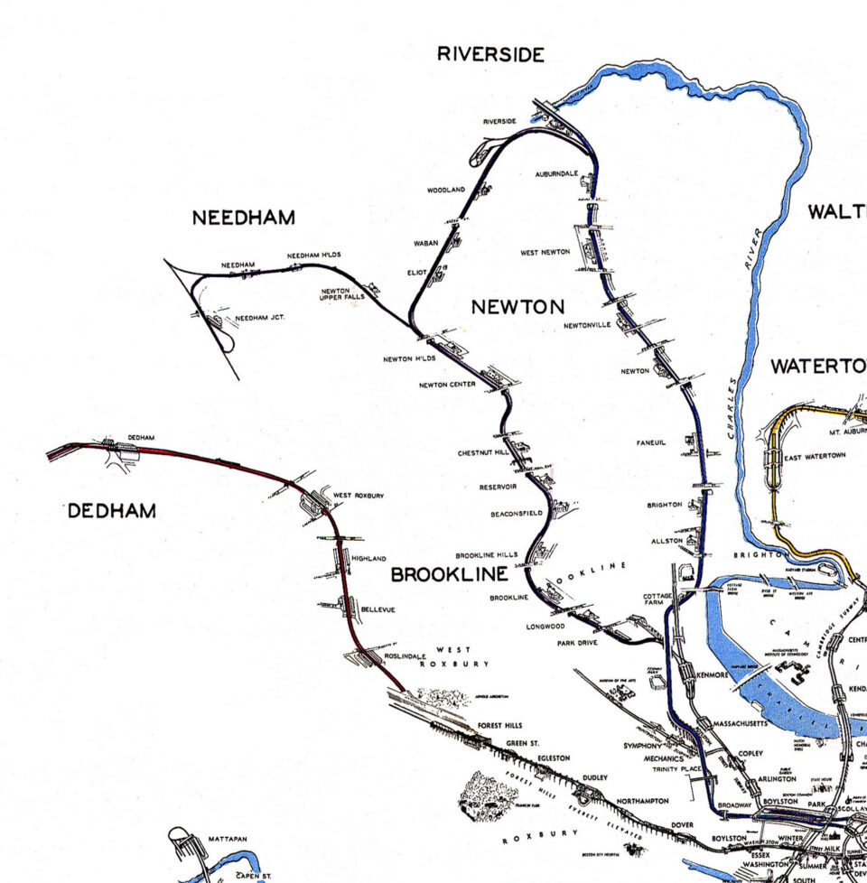
The Boston & Albany Railroad ran west through Newton and featured a large loop line through the leafy suburbs known as the Riverside Line. In 1945 the Coolidge Commission proposed to convert this loop, along with another branch to Needham, into rapid transit service and connect it to the Green Line through a new tunnel under South Cove to the Tremont St Subway. The section of the Green Line from Park St to Scollay Sq was to be expanded from two tracks to four.
In 1959 the Riverside Line was successfully incorporated into the Green Line as the D branch but was connected to the network at Kenmore Sq rather than Boylston. The line proved so popular that streetcars had to be transferred from other lines to serve the new branch. This ultimately led to the abandonment of many of the remaining streetcar lines in the system, including the A branch.
7. Green Line to West Medford and Woburn: 1945-Present
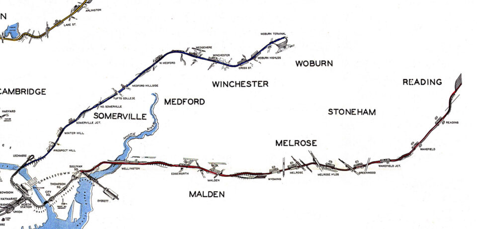
Ideas to extend the Green Line north of Lechmere station had existed since the 1920s but were formalized in the Coolidge Commission which proposed extending it along the Lowell Line to Woburn. In the 1990s the Commonwealth began to seriously look at extending the Green Line north through Somerville. Planning began in 2006 and ground was broken in 2012. Two branches were proposed: D trains would run to College Ave in Medford and E trains would run to Union Sq in Somerville. The original concept included two more stations at Medford Hillside and West Medford but due to the extra costs involved with bridging the Mystic River these have been deferred to a future phase. The extension is planned to open by the end of 2021.
8. Green Line Watertown and Arborway Branches: 1969-2005

Beginning in the 1920s the streetcar lines of Boston were systematically converted to buses and the tracks ripped up. In 1962 the last lines ran through the Pleasant St Portal and the southern branch of the Tremont St Subway was abandoned. Unlike the B and C branches, most streetcars ran on narrow city streets and not in their own traffic-separated medians. Subways had been planned which were to replace the A, B and E branches but only the Huntington Ave Subway was built for E trains.
In 1969 the A branch, from Watertown Sq to Packard’s Corner in Brighton was “temporarily” replaced with buses due to a shortage of streetcars. The overhead wires were removed in 1994 and the tracks in 1996. Since then, there have been no serious proposals to bring the A branch back.

The E branch runs in a dedicated median along Huntington Ave until Brigham Circle, after which it runs on tracks in the middle of traffic to a loop at Heath St and South Huntington Ave. Formerly the line ran all the way to Forest Hills and was known as the Arborway Line. In 1985 the street-running portion past Brigham Circle was replaced with buses as it was assumed that the soon to be open Orange Line Southwest Corridor line would serve Jamaica Plain better.

As part of a law suit against the Commonwealth in the 1990s, service to Arborway was to be reinstituted as mitigation for the Big Dig. The City of Boston opposed streetcar service and began ripping the tracks up in 2005, ending any hopes of returning service on the line.
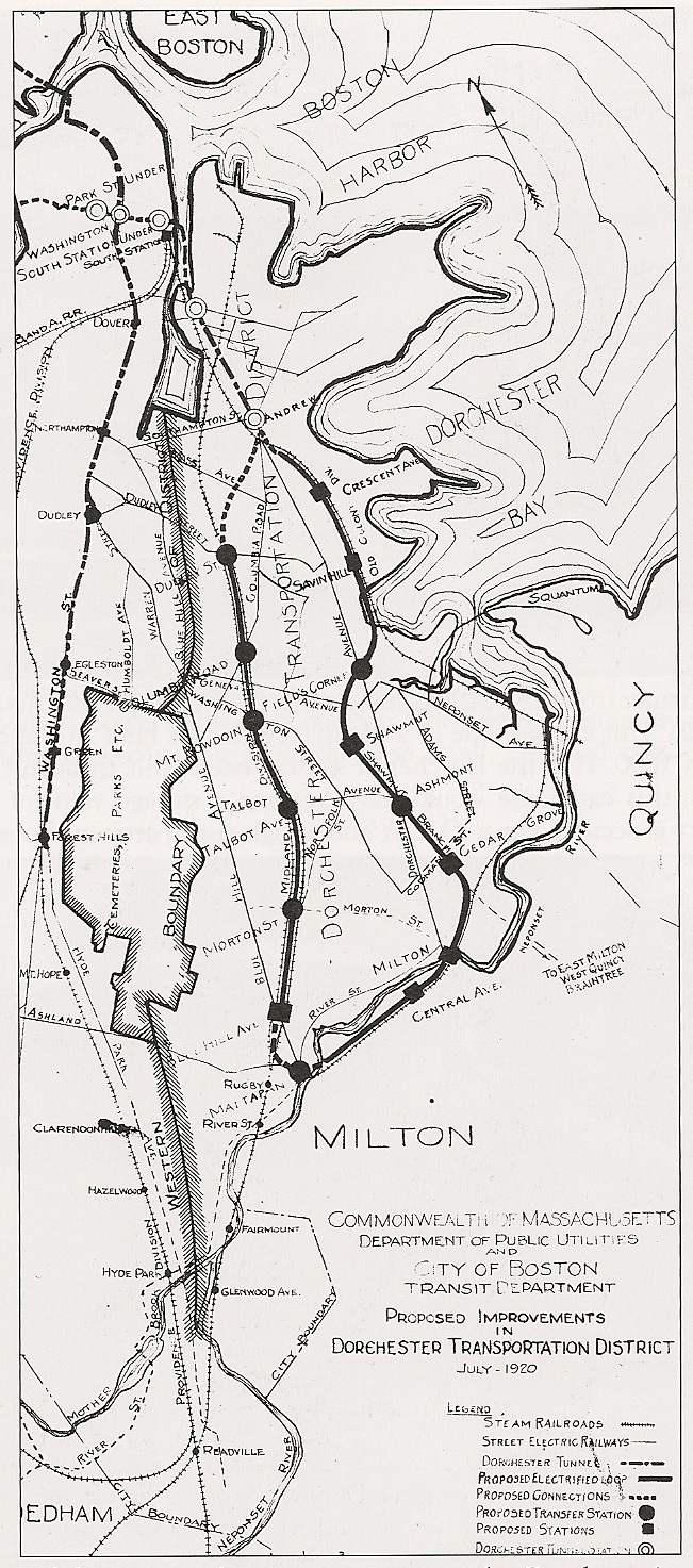
9. Red Line South Shore Branch: 1945-1980
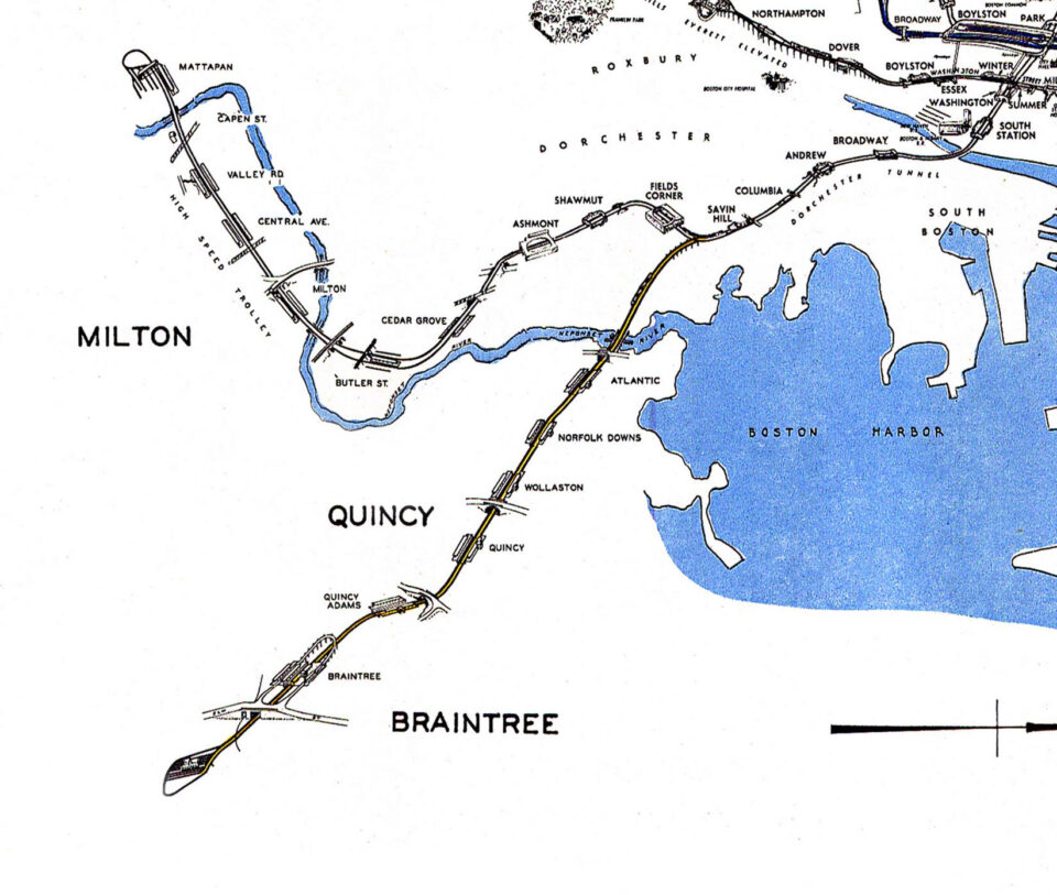
After World War II the South Shore saw massive suburban growth while at the same time the Old Colony Railroad was going bankrupt. The Coolidge Commission proposed that the Old Colony tracks be bought and converted to one or more branches of the Red Line. Initially a branch was to run from Savin Hill to Braintree. A second proposal in the 1960s included extending the Ashmont branch across the Neponset River to Granite Ave in East Milton to build a large Park-and-Ride terminal
As plans developed into the 1950s the branch connection was moved up to Andrew station as a kind of bypass of Dorchester. An original station from the Old Colony Line at Atlantic (Quincy Shore Dr) was eventually dropped. Secondary branches off the Braintree extension were proposed with one to Holbrook and one to South Weymouth. The South Shore extension was opened in phases, first to Quincy in 1966 and eventually to Braintree in 1980.
10. Red Line Northwest Extension: 1945-1985
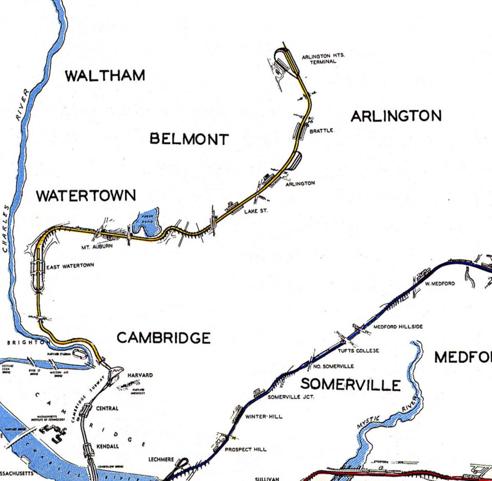
Two plans were conceived to extend the Red Line past Harvard station. The Red Line proper was to be extended west from Harvard Sq to East Watertown along what is today Greenough Blvd. The Lexington Branch railroad running through Arlington and Lexington was to be converted into a high-speed trolley (similar to the Mattapan Line) and would run to East Watertown via the Watertown Branch railroad through what is now Alewife.
In 1947 a more sensible alternative was proposed which extended the Red Line north to Porter Sq and then west along the Fitchburg Branch railroad to Alewife. As this plan was further developed possible extensions to Waltham or Arlington were included and a station at Davis Sq was added.
After Governor Francis Sargent suspended highway construction in the Boston area in 1972 former highway funds were available for subway expansion. The Red Line was formally proposed to be extended from Harvard to Arlington Heights as a first phase and a then to Route 128 in Lexington as a future second. Arlington residents protested as they believed a “temporary” terminal in their town would bring too much traffic. The Arlington section was cut and the extension to Alewife was opened in 1985.
11. Blue Line to Wonderland and Lynn: 1945-Present
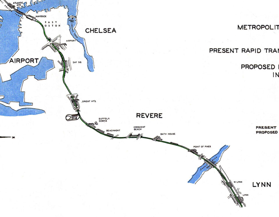
The Boston, Revere Beach & Lynn Railroad was a narrow-gauge railroad running from East Boston to Winthrop, Revere and Lynn serving mostly summer beach goers. It had been eyed for rapid transit conversion early on in the development of the subways and this was formally proposed as part of the Coolidge Commission (the branch to Winthrop was abandoned).
Between 1952 and 1954 the section from East Boston to Revere Beach was converted to the Blue Line. Due to lack of funds the further extension to Lynn was postponed indefinitely. Today the former right-of-way has been allowed to be redeveloped so any potential extension to Lynn will most likely run parallel to the Newburyport Line instead.
Alternatively, in the 1960s a proposal was floated to extend the Blue Line one station west to the Salem Turnpike where a large Park-and-Ride terminal would be built.
12. Red-Blue Connector: 1970s-Present
In the latter half of the 20th Century as the tech and life science industry began to boom in Cambridge, it was proposed to extend the Blue Line from its terminal at Bowdoin one stop to Charles/MGH to create a new transfer point in the core of Boston. A connection once existed between the two lines using streetcar tracks but this was only used for non-revenue moves to send Blue Line trains to the yard in Harvard (the portal at Joy St was covered up in the 1950s). The Red-Blue Connector as it’s known was included as a Big Dig mitigation project in the 1990s but was ultimately dropped due to lack of funds.
13. Orange Line Southwest Corridor: 1945-1987

After World War II planners saw the need to extend the Orange Line ever deeper into the suburbs. South of the Forest Hills terminal the Needham and Dedham Branch railroads were to be converted to rapid transit with the Orange Line extending through West Roxbury and south to Dedham or west to Needham.
When the Federal Interstate Highway program was funded planners saw a way to take advantage of the new highways by designing the proposed Southwest Expressway with the Orange Line relocated down the median (as had been done in Chicago). An alternative subway along Shawmut Ave to Dudley Sq was deemed too expensive. The Southwest Expressway was to replace much of the defunct New Haven Railroad (now the Northeast Corridor) with all remaining rail traffic being moved to the Fairmount Line.
As part of the relocation the Orange Line was to be extended to Needham and also to Route 128 via Hyde Park. Much of the route through Roxbury was cleared for the highway as protests erupted against the road. In 1972 Governor Francis Sargent canceled all new highways inside of Route 128, including the Southwest Expressway, and transferred the funds to mass transit. The cleared land through Roxbury was reimagined as a transit and ribbon park corridor. The Orange Line was relocated along the Southwest Corridor along with expanded commuter rail lines which were chosen by the more suburban residents of West Roxbury and Hyde Park over Orange Line service.
14. Orange Line North: 1945-1975
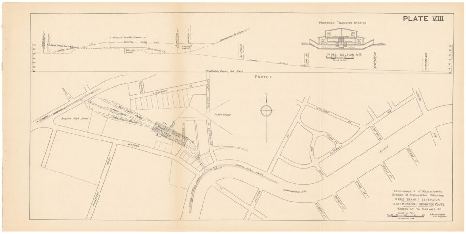
BERy had attempted to extend the Orange Line north in the 1920s but was stopped by local opposition to elevated trains. In 1945 the Coolidge Commission proposed to convert the Reading Branch of the Boston & Maine Railroad to rapid transit as an extension of the Orange Line to Route 128. The extension would have begun at Haymarket station and run in a new tunnel to Charlestown where it would come to the surface and run north. This allowed the elevated tracks from North Station to Everett to be demolished. Planning began in the 1960s and included the first express track in the system so that trains from Reading could bypass Charlestown.
While construction was ongoing in the late 1960s and early 1970s, residents of Melrose, Wakefield and Reading objected to Orange Line service and fought for restoration of commuter rail. The MBTA eventually gave in as they didn’t have the funding the extend the Orange Line north of Oak Grove in Malden. The third express track, partially built, was never used for revenue service and commuter rail service through Reading is limited to one track because of the confined right-of-way next to the Orange Line.
A station at Edgeworth was dropped from the original plan. In 2014 an infill station at Assembly Sq was opened.
15. Silver Line: 2000-Present
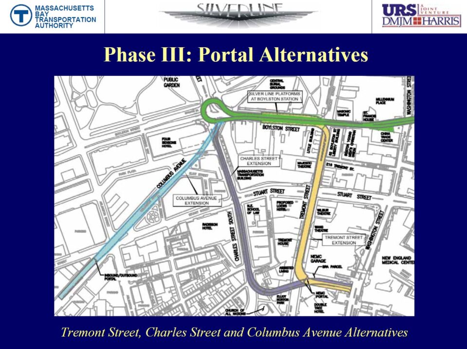
The Washington St Silver Line opened in 2001 as a Bus Rapid Transit (BRT) line from Dudley Sq (now Nubian) to Temple Place in downtown Boston. It was chosen over light rail to replace the demolished Washington St El after the Orange Line had been relocated to the Southwest Corridor.
The second phase, using the new South Boston Piers Transitway, opened in 2004 with service to Logan Airport and City Point in South Boston. Other potential branches were hinted at but ultimately none were ever implemented and the City Point branch was cut back to the South Boston Design Center in 2009.
Phase 3 of the Silver Line was to be a complex tunnel below the Theatre District which would have connected both sides of the line. The tunnel required buses to drive a convoluted route under narrow streets and, in one version, completely rebuild the existing but unused Tremont St tunnel south of Boylston St. The costs and complexity killed the plan in 2009 and the MBTA shifted focus to the Green Line Extension through Somerville. As a result, the Washington St Silver Line was split into two street running services, one to Temple Pl and the other to South Boston.
A southern extension of the Silver Line to Mattapan and Ashmont were proposed early on. This would have converted the 28 and 22 or 23 bus lines to BRT under the Silver Line brand. In 2008 Federal funds were secured to build a BRT line, the 28X, along the route but was killed by local opposition that claimed the funds were secured without consulting residents beforehand.
16. Urban Ring: 1990s-Present
The Urban Ring was a multi-phased proposal to create a new, circumferential transit way around the core of downtown Boston so that riders wouldn’t have to go all the way downtown to transfer. The first phase was a reorganization of the crosstown bus lines and implementation of new crosstown bus lines, mostly through Cambridge and into Boston.
Phase 2 was to encircle Boston with a series of Bus Rapid Transit lines running in dedicated lanes and connecting to subway stations and major job centers. The projected cost for these lanes was $2.2 billion in 2008. Phase 3 was to build a fixed rail line along a corridor from Sullivan Sq to MIT, to Kenmore Sq or just west of it, and through the Fenway and to Dudley Sq (now Nubian). This would have either been light rail as a branch of the Green Line or a heavy rail branch of the Orange Line.
In 2018 a new branch of the Silver Line was opened from East Boston to Chelsea along part of the projected route of the Urban Ring. Running mostly along a dedicated right-of-way, this branch of the Silver Line is being considered as a first step towards a new Urban Ring with possible extensions west or north.
17. North-South Rail Link: 1890s-Present
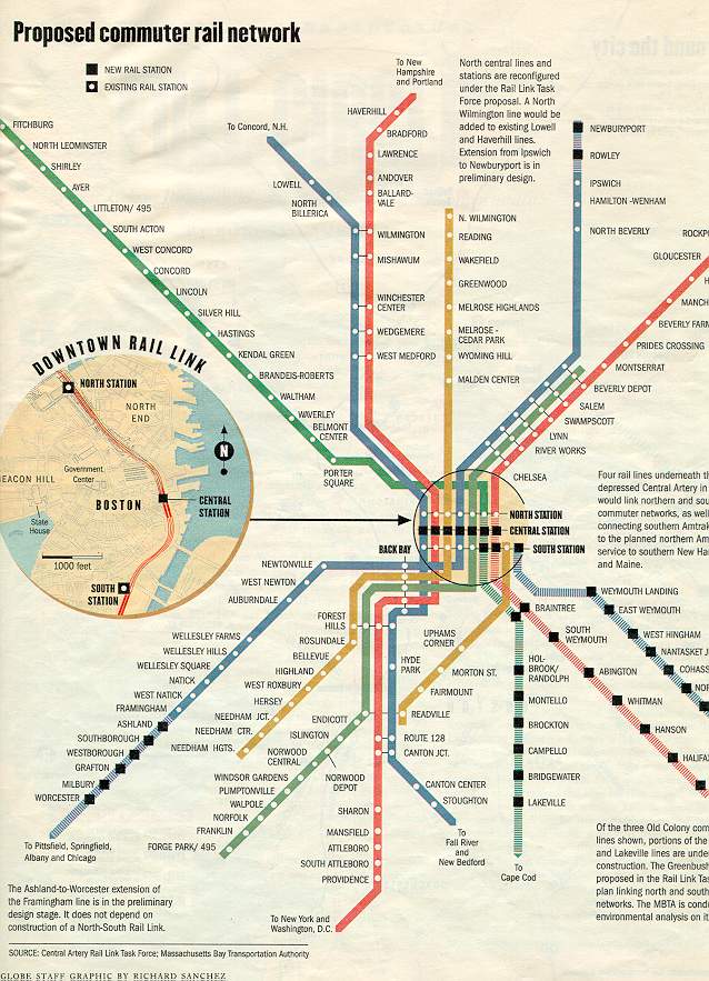
Early steam railroads each had separate terminals around the outskirts of downtown Boston. In the 1890s two new terminals, North Union Station and South Union Station, were built to simplify operations. Since then, it has been a dream to connect the two via a tunnel under downtown Boston. Freight trains once ran between the two terminals via Atlantic Ave as they served the warehouses and shipping industries, but as these declined so too did the need for the rail service. The Atlantic Ave El once connected riders from South Station to North Station but was demolished in the 1930s due to declining ridership.
When the Central Artery and Tunnel Project was first proposed in the 1980s it was the transit-friendly Governor Michael Dukakis who insisted that a North-South rail link be included. As the cost and scope of the project ballooned the rail link was soon dropped but the highway tunnels were designed so that a future rail tunnel could be built below them with no obstacle.
The North-South Link has been studied as recently as 2018 as either a two-track or four-track tunnel. Plans have called for up to three stations: at North Station, South Station, and a Central Station near the Aquarium station on the Blue Line.
18. Track 61: 2010s-Present
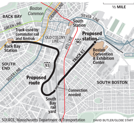
In 2013 the MBTA and MassDOT proposed using a track, known as Track 61, for passenger service from Back Bay to serve the Boston Convention and Exhibition Center (BCEC). Track 61 was once part of the Boston & NY Central Railroad which ran along the present-day Fairmount Line to a terminal near South Station (crossing Fort Point Channel). Passenger service ceased in 1896 when it was moved to the new South Station, after which the track served only freight to the warehouses along the waterfront. It’s the only rail connection to the South Boston Waterfront and extends to Black Falcon Pier along the Reserve Channel.
New passenger service would run from Back Bay station to the Fort Point Channel, turn south to Widett Circle and loop back north. A new flyover track would need to be built above the MBCR and Red Line tracks. Alternatively, trains using the Fairmount Line would terminate at BCEC as well as South Station.
New Diesel Multiple Unit trains were to be used on the extension as well as to convert the Fairmount Line to rapid transit-like service. The order for these trains was canceled in 2015 and no funding has been found for either the new trains or service.
19. West Station and Grand Junction: 2010s-Present
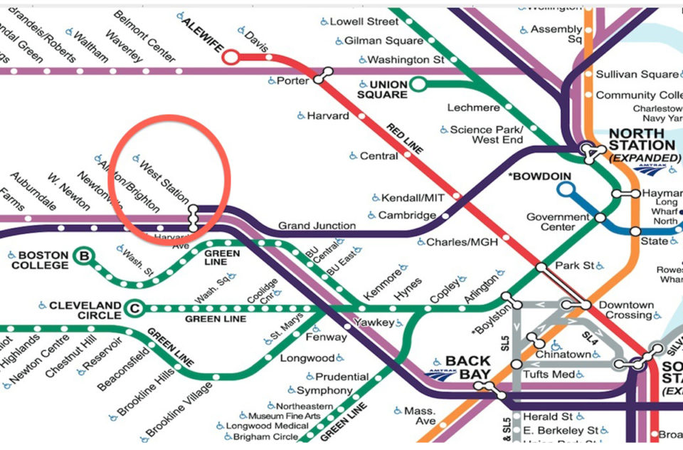
In 2013, as part of the development of the Beacon Park Yard and straightening of the Mass Pike through the area, MassDOT proposed a new station along the existing Worcester Line in Allston that would serve new development in the area. West Station, as it is known, would also serve trains using the Grand Junction Railroad through Cambridge to North Station. Current plans for the station have a completion date of 2040.
Cool! By the way you should add the GLAM proposed alternate for glx.
What is the GLAM alternative?
The GLAM proposal (plus some other alternate alignments) can be found here: https://wayback.archive-it.org/6359/20170103142512/http://greenlineextension.eot.state.ma.us/documents/draftEIR/App_B_thru_J/133_AppB_StationAlignSelAnalysis.pdf
I’m surprised I’ve never seen these. Thanks!
I also know of some early bery proposals.
https://bostonintransit.com/collections/boston-transit-commission-annual-report-12-1906