
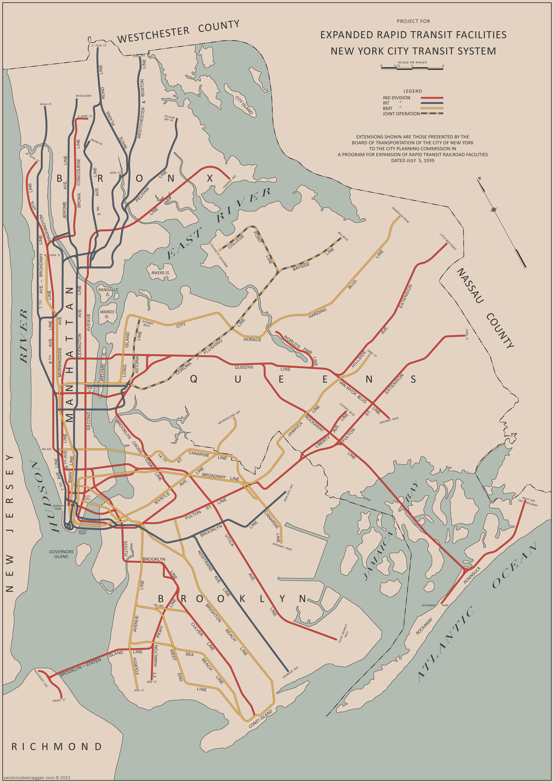
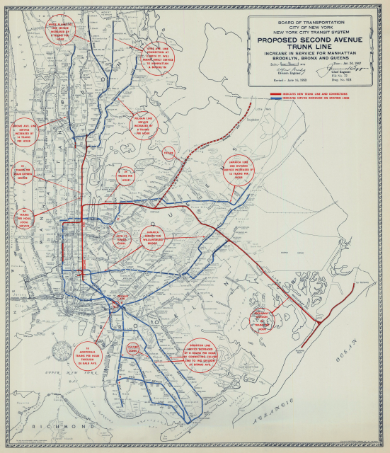
Students of NYC subway history know this map. It is one of the two official maps for the IND Second System plans from 1939. The original, 1929 plan, was published in the New York Times, but this second map’s origin were more unclear. The map in question comes from a technical report, “Report on Power Supply of the New York City Transit System” by the J. G. White Engineering Corp., published in 1940.
I know this because a while back I picked up a copy of this book off of eBay. As the name suggests, the report is mainly focused on the power systems of the subway. This is the only “expansion” map in the report, and was made so that the engineers could understand the potential changes needed to the power system. As subway power was never much interest to me, I never read through the report. That is, until I had to move this last month.
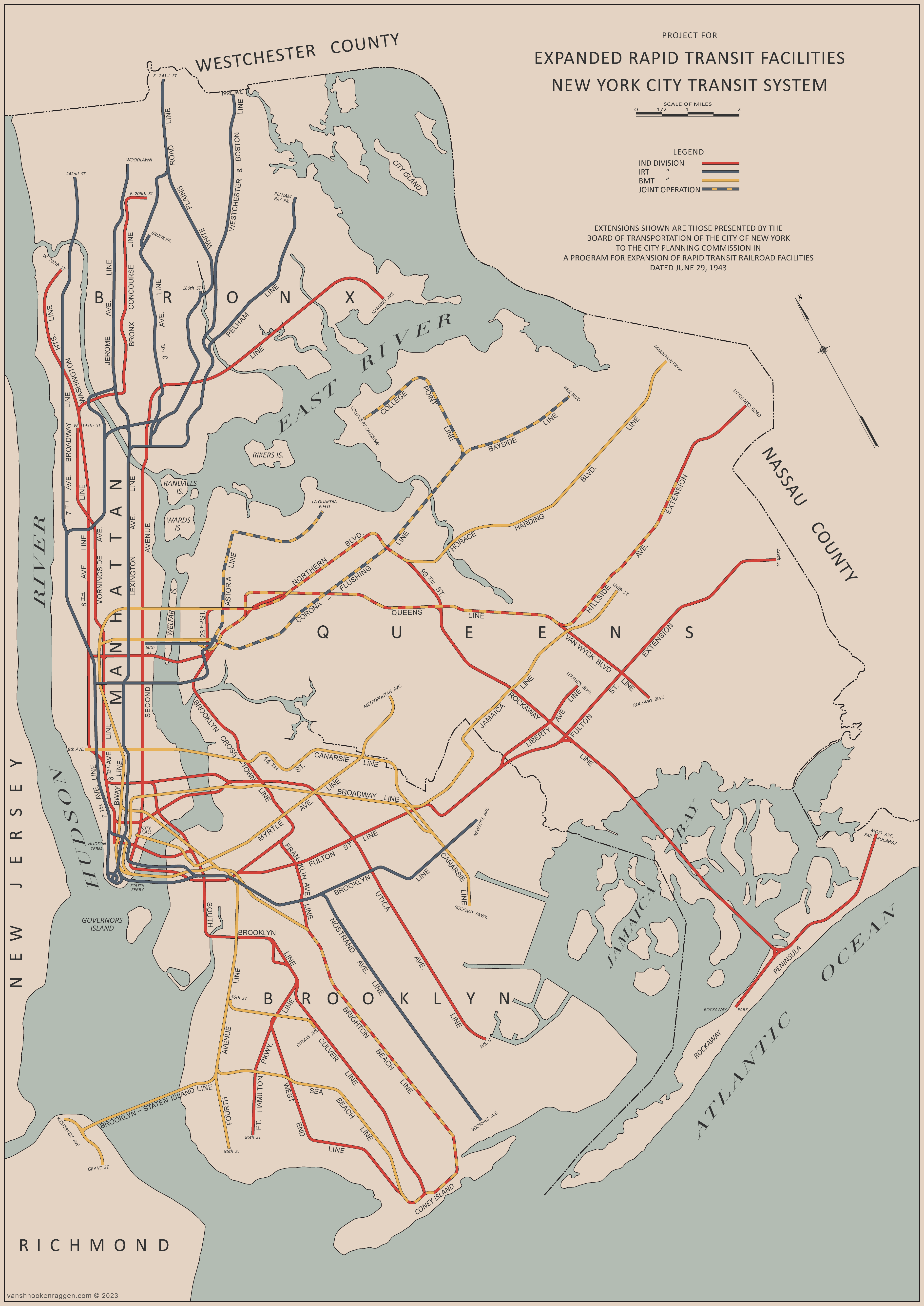
At the very end of the report are two memos from the Chairman of the Board of Transportation, John H. Delaney. I’ve taken images of these, from the report, and posted them on my Flickr account. The first memo is from July 5th, 1939 and is a written description of the 1939 map. But the second is from a year later, July 16th, 1940, after subway unification has passed. This memo outlines a number of different lines, changes which are not as well known to the city’s subway expansion plans, and for which no map exists.
Until now.

I decided to copy the 1939 map and make the changes proposed to show the evolution of the Second System. The plans of the city changed often throughout the 1930s as the realities of building subways, especially during the Great Depression, changed the priorities of the system. Originally, the IND was built to compete with the private companies (IRT and BMT), as well as replace the network of older elevated lines which were seen as depressing real estate values.
With the opening of the original IND system, ridership dropped on many of the private lines, forcing the IRT and BMT ever closer to bankruptcy. The intention was for the city to drive the private companies to sell their leases back to the city, which would unify all three systems. Once the systems were unified, the city would then combine and extend lines on their own.
The IRT and BMT chose to keep their new lines as cheap as possible to build, often sticking to new elevated lines when opposition to them was less strong. The IND wanted the elevated lines gone, so their new subways were designed much more extravagantly and complex, which greatly drove up the cost. By the end of the 1930s, with unification of the system close, the expansion plans were reigned in to utilize more of the existing network rather than wholesale replacement.
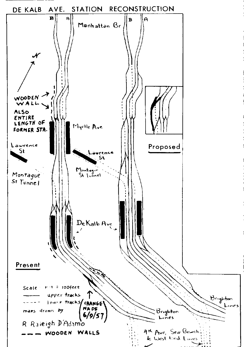
This change is even more apparent in the 1940 plan, which could utilize much more of the existing network. The major focus at the time was the bottleneck at DeKalb Ave station in downtown Brooklyn. The station featured a complex, all at grade interlocking which severely limited how many trains could pass through per hour. This was compounded by the fact that the BMT had decided to use this station as the nexus point for their entire system. Almost every BMT line had to run through DeKalb Ave at some point, limiting service on every branch.
The IND took aim at DeKalb early on with their South Brooklyn-Propsect Park Line (today the F/G trains) which was specifically designed to reroute the BMT Culver Line away from the BMT 4th Ave trunk line (which feeds into DeKalb Ave). The IND built their new subway with 4-tracks to Church Ave with full intent to recapture the BMT Culver Line (which the city owned but was leased to the BMT). The IND also made the decision to replace the BMT Fulton St Line with a subway, when it was clear there was no room to route these trains through DeKalb Ave. With unification, even more could be done to improve service to southern Brooklyn.
Additionally, the IND was looking at ways to improve service to Queens, which was seeing massive development, mostly due to the opening of the subways to begin with. The IND had cut corners on their design of their Queens Blvd Line by having only the express trains cross into Manhattan; all local service was routed to Brooklyn on the Crosstown Line (G train).
Finally, the IND had been pressured by community and business interests in Bay Ridge and Staten Island to include a tunnel to St. George. This tunnel had actually been started in 1923, but was cancelled two years later due to a lack of agreement between the city and freight railroads. The tunnel was originally going to connect to the BMT 4th Ave Line, but the bottleneck at DeKalb Ave made such a connection infeasible unless more service could be added. As such, the IND devised a plan to extend the Staten Island tunnel deeper into Brooklyn, through Bensonhurst, and connect to the end of their new South Brooklyn-Prospect Park Line.
1939 vs 1940
In the 1939 memo, Delaney lists out the proposed projects in order of importance.
| 1939 | Cost (Millions) |
| Hillside Ave Extension Phase 1: 4 track subway, 178th St to 184th St* | $3.455 |
| Fulton St Line Extension: 4 track subway, Grant Ave to 106th St | $18.55 |
| Rockaway Line Acquisition and Reconstruction* | $38.427 |
| Connection from Rockaway Line to Fulton St Extension* | $1.933 |
| Second Ave Line: 2 and 4 tracks, 2 track river tunnel, Court St, Brooklyn, to Harding Ave, The Bronx | $217 |
| 6th Ave Extension: 2 track subway and river tunnel 53rd St, Manhattan, to Steinway St, Queens** | $30.74 |
| Houston St and Utica Ave Line: 2, 4, and 6 track subway and river tunnel, Essex St, Manhattan, to Floyd Bennett Field and Marine Park, Brooklyn | $147.24 |
| 6th Ave Line: 2 additional express tracks between West 9th St and West 31st St* | $17.97 |
| Flushing Line: 4 track subway to 149th St, 2 track subway to Bell Blvd, embankment and open cut | $10.498 |
| Hillside Ave Extension Phase 2: 4 track subway, 184th St to 212th St | $16.335 |
| Worth St Line: 2 track subway and river tunnel, Church St, Manhattan, to Driggs Ave, Brooklyn | $30.31 |
| Hillside Ave Extension Phase 3: 2 track subway, 212th St to Little Neck Rd, Queens | $13.52 |
| Van Wyck Blvd Line: 2 track subway, Hillside Ave to Rockaway Blvd** | $13.34 |
| Flushing Line: 2 track elevated from 149th St to College Point | $11.96 |
| Nostrand Ave Line: 2 track subway and elevated, Flatbush Ave to Voorhies Ave | $19.74 |
| Fulton St Line Extension: 2 and 4 track subway, 106th St to 229th St | $42.71 |
| Brooklyn-Staten Island Line: 2 track subway and river tunnel, 10th Ave/68th St, Brooklyn, to New Brighton and Tompkinsville, Staten Island | $43.112 |
| Ft. Hamilton Parkway Line: 2 track subway, E. 5th St to 86th St, Brooklyn | $18.8 |
| Long Island City, Astoria, and Horace Harding Blvd Line: 2 and 4 track subway and storage yard, LIC to Marathon Pkwy, Queens [along 21st St, Ditmars Blvd, Astoria Blvd, 99th St, Corona Ave, Horace Harding Blvd.] | $131.58 |
| 7th Ave Line Extension: 2 track subway, 59th St to 145th St, Manhattan | $30.36 |
The 1940 memo was presented in the same format. I have highlighted the changes.
| 1940 | Cost (Millions) |
| Culver Line: Connection to the Prospect Park-Coney Island Line and rehab of structure* | $11.266 |
| Broadway-Lenox Ave Line: 2 track subway and elevated connection to the 162nd St spur of the Jerome Ave Line | $2.84 |
| Hillside Ave Extension Phase 1: 4 track subway, 178th St to 184th St* | $3.455 |
| Queens Blvd Line-60th St Tunnel Connection: 2 track subway* | $11.55 |
| West End Line-Smith St Connection: 2 track subway and ramp between West End Line and Smith St-Prospect Park Line | $5.32 |
| Fulton St Line Extension: 4 track subway, Grant Ave to 106th St | $18.55 |
| Rockaway Line Acquisition and Reconstruction* | $34.380 |
| Connection from Rockaway Line to Fulton St Extension* | $1.933 |
| Dyre Ave-Pelham Bay Line Connection: 2 track connection at East 174th St** | $1.85 |
| Second Ave Line: 2 and 4 tracks, 2 track river tunnel, Coenties Slip, Manhattan, to Harding Ave, The Bronx | $194 |
| Worth St Line: 2 track subway and river tunnel, Church St to Bowery, Manhattan | $10 |
| Houston St and Utica Ave Line: 2, 4, and 6 track subway and river tunnel, Essex St, Manhattan, to Floyd Bennett Field and Marine Park, Brooklyn | $147.24 |
| 6th Ave Line: 2 additional express tracks between West 9th St and West 31st St* | $17.97 |
| Flushing Line: 4 track subway to 149th St, 2 track subway to Bell Blvd, embankment and open cut | $10.498 |
| Hillside Ave Extension Phase 2: 4 track subway, 184th St to 212th St | $16.335 |
| Worth St Line Extension: 2 track subway and river tunnel, Bowery, Manhattan, to Driggs Ave, Brooklyn | $23.48 |
| Hillside Ave Extension Phase 3: 2 track subway, 212th St to Little Neck Rd, Queens | $13.52 |
| Van Wyck Blvd Line: 2 track subway, Hillside Ave to Rockaway Blvd** | $13.34 |
| Flushing Line: 2 track elevated from 149th St to College Point | $12.26 |
| Nostrand Ave Line: 2 track subway and elevated, Flatbush Ave to Voorhies Ave | $19.74 |
| Fulton St Line Extension: 2 and 4 track subway, 106th St to 229th St | $42.71 |
| Brooklyn-Staten Island Line: 2 track subway and river tunnel, 4th Ave/68th St, Brooklyn, to New Brighton and Tompkinsville, Staten Island | $38.27 |
| 6th Ave Line Extension: 2 track subway, 53rd St to 145th St, Manhattan | $30.36 |
| 7th Ave Line Extension: 2 and 4 track subway, river tunnel and storage yard, 59th St to 72nd St, Manhattan, [to Queens via 36th Ave, Northern Blvd, 99th St, Corona Ave, Horace Harding Blvd] to Marathon Pkwy, Queens | $144.89 |
| Second Ave Line Extension: 2 track river tunnel, Coenties Slip, Manhattan, Court St, Brooklyn | $19.15 |
| Franklin Ave Line: 2 track subway, Eastern Pkwy to Lafayette Ave, Brookyln | $7.68 |
| Ft. Hamilton Parkway-10th Ave Line: 2 track subway, 37th St to 86th St, Brooklyn | $14.76 |
At the end of the memo Delaney mentions a number of projects of importance, the connection between the South Brooklyn-Prospect Park Line to the Culver Line being the priority. This connection would eventually be built, but it would take until the creation of the NYC Transit Authority to open it in 1954.
The next priority was the connection of the Broadway-Lenox Ave Line (3 train) with the Jerome Ave Line (4 train) along the former 9th Ave El connection located at the Polo Grounds. The Jerome Ave Line once featured reverse branching to provide service to the east side (Lexington Ave Line) and west sides (9th Ave El). With the removal of the El, Jerome Ave riders lost this direct access to the west side. A shuttle between the Jerome Ave Line and the Polo Grounds ran until 1958, after which the last remaining elevated structure was removed. Since the IND’s Concourse Line ran a few blocks to the east of the IRT Jerome Ave Line, riders needing west side service simply used the IND instead.
The Queens Blvd Line, being poorly designed from the beginning, was the next priority. A connection to the BMT 60th St Tunnel, which opening in 1955, added considerable capacity to Manhattan-bound trips. It’s used by the R train today. At the opposite end of the line, the 169th St station, which had never been designed to be a terminal, was limiting the amount of express trains which could run. The line was eventually extended to 179th St, with a large, bi-level underground storage yard built to 184th St, in 1950.
Even with the added capacity to the Queens Blvd Line, the Board of Transportation knew that it could not handle the added traffic from the Rockaway Line. A connection to the Fulton St Line was prioritized, and this opened in 1956. The northern end of the Rockaway Line was eventually abandoned in 1962, but I am personally fighting for this section to be rebuilt and connected to the Queens Blvd Line, now that the 63rd St Tunnel has been connected.
Finally, Delaney speaks about the continued capacity constraints because of DeKalb Ave. Connecting the BMT West End Line (D train) to the South Brooklyn-Prospect Park Line (F/G) would boost capacity on the 4th Ave and Brighton Beach Lines even more. The Brighton Beach Line truncates from 4-tracks to 2-tracks north of Prospect Park station, so connecting the outside tracks (which are only still used for the Franklin Ave Shuttle) to the Crosstown Line, would add 50% capacity on the line, while also fulfilling the original design of the Crosstown Line.
1943 Addendum
While researching these changes, I came across a 1943 Board of Transportation report which outlined a number of smaller additions to the 1940 list. Because these changes dovetail into the 1940 plan, I’ve elected to include them in the updated map. These changes include:
| 1943 | Cost (Millions) |
| Connection between the Crosstown Line and 7th Ave-Horace Harding Line: 2 track subway, Jackson Ave to 36th Ave, along 23rd St | $10.95 |
| Connection between the 7th Ave-Horace Harding Line and Rockaway Line: 2 track subway, Queens Blvd to Corona Ave, along 99th St | $9.2 |
| Astoria Line Extension to LaGuardia Airport: 2 track elevated, along Ditmars Ave to La Guardia Airport | $10.5 |
1947 Onwards
By 1947, the realities of the post-war economy and unification had set in. The subways that the city took over in 1940 were in far worse shape than originally predicted, and the city struggled to find funds to finish the IND Fulton St Extension to Grant Ave, which had been postponed because of the War. Ridership dropped dramatically, as gasoline rationing stopped and focus on building highways took center stage.
By 1947, almost all of the ambitious plans from the IND Second System were dropped. The city focused entirely on 2nd Ave, as the Lexington Ave Line was more crowded than ever. The bottleneck at DeKalb Ave was to be rebuilt with a flying junction, a much cheaper alternative than building new subways bypassing the station. This rebuild wasn’t open until 1961.
While other lines in were proposed in 1950, including the Utica Ave Line, and connecting the Rockaway Line and Port Washington Line (LIRR) to a new express tunnel into Midtown, these were used for bait, to sell the public on a massive $500 million ($6.3 billion in 2023) bond act. This money went towards rebuilding the system instead of expanding it.
After the opening of the Fulton St Line extension in 1948, the city could not find the money to build any project from this list. It took the creation of the NYC Transit Authority (TA) in 1953, which as a public authority to authorize their own debt-backed bonds, before funds could be raised and work begun. The TA was rather successful in building, and opened the Culver Line Connection, Queens Blvd-60th St Connection, Dyre Ave-180th St Connection, Hillside Ave Extension to 184th St, and acquiring the Rockaway Line from the LIRR. Building the additional express tracks under 6th Ave, from West 9th St to West 31st St and opening of the Chrysite St Connection in 1967, was the last expansion project build by the TA.
It was in the 1950s where the city began to lose population. The suburbs were booming, and commuters shifted to cars and highways. With the growth of Queens (and stagnation of Brooklyn), planning shifted to a new tunnel between Long Island City and Midtown Manhattan, and which services could use the new tunnel.
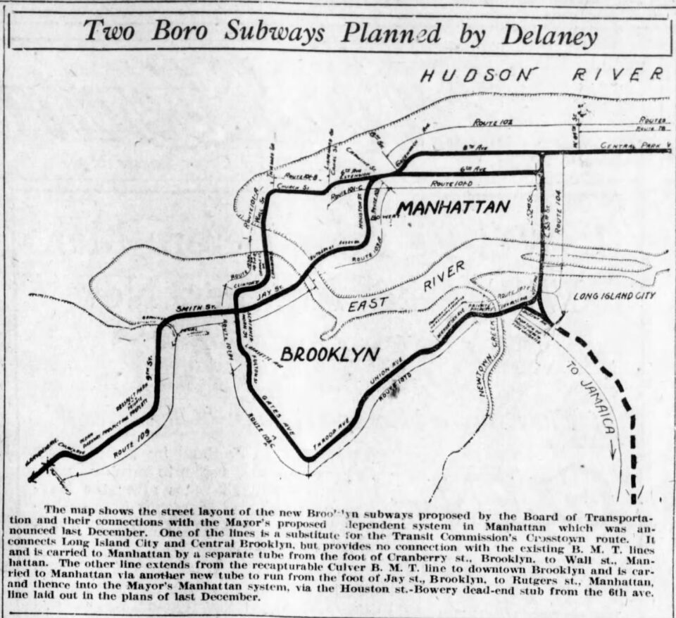
In 1963, the TA and City drew up plans for the new tunnel, which show their origins in the IND Second System, but were modified for the needs of a new generation. It’s interesting to see on this map that the TA still had the plans for a Central Park express bypass, the Northern Blvd-Horace Harding Line and Fulton St Extensions in their mind. With costs rising, planners looked to save money by incorporating commuter rail lines into the system instead of building new tunnels. Eventually, these both were morphed into the Plan for Action, but are still dreams unfulfilled to this day.
Let’s take a look at one of the proposed changes (which happens to be closer to my old stomping grounds in Howard Beach): the proposed Fulton St extension of the A train past Grant Avenue:
Since no streets are given, I’ll have to guess at the details: My guess is that it would have been a two-track line (the geography would not have permitted a four-track line) running under Pitkin Ave to Sutter Avenue (where the Q7 bus runs now) going under a part of Sutter Avenue now undefined (past 96th St, then going directly under what is now MS137 (America’s School of Heroes). etc. emerging somewhere around the “five points” of southeast Queens: the intersection of 109 Avenue, Rockaway Blvd, Plattwood Ave and Centerville St coming and going in various directions not too far away from Jhon Adams High School. The line would have probably gone under 109 Avenue (where the Q41 bus runs in part) past the Van Wyck Expressway, making a sharp right left combination turn at Sutphin Blvd (in keeping with the layout of 109 Ave), making a sharp left right combination turn at Merrick Blvd / 171 Street (again as the layout of 109 Avenue goes — or does it make a right turn and go under Brinkerhoff Avenue and under the LIRR tracks near 180 St?) past an intersection with Liberty Avenue around 189th St resuming the 109th Avenue designation at the intersection of Farmers Blvd going as far as Hollis Avenue, making a right turn and heading as far east as Springfield Blvd around 104th Avenue (the Q 2 bus runs part of its present route on Hollis Avenue) which runs as far as 217 St.
The only problem I have now is defining the proposed terminal at 219th St — which Avenue was intended for it to be: Murdock Avenue (where the Q83 partially runs now)? 115th Avenue (with a possible extension into Nassau County via Dutch Broadway)? Or perhaps 107th Avenue (where a quick Google Maps search reveals a now blocked off access road to the Belmont Park parking lots from the Cross Island Parkway southbound where 107th Avenue becomes the service road of the Parkway)? do you have more details than what is on the 1939 map?
Based on the shape of the line, I would assume that they meant for the line to run to, and extend along, Linden Blvd.
For the Utica Avenue Line for the 1943 map, was it supposed to cut underneath all those streets and buildings in that shape like that? (it looks like if Bushwick Avenue made a similar curve to Broadway)
They would have cut a new street between Union Ave and Beaver St, creating a single avenue parallel to Broadway to “improve” traffic going towards the Williamsburg Bridge.
https://www.google.com/maps/d/u/0/edit?mid=1lQQm2htn5fWTxnG8EPxvBQ6ruSeyVqvh&usp=sharing
Ahh man. Such a shame a big belly plan like that never went into fruition. I wonder how it would be done in 2023? I perhaps feel a tunnel under Meserole Street would continue until turning down Humboldt Street and then making a slight right curve down Beaver Street. Or maybe the 8th Av line would’ve split down Broadway until turning down Myrtle,
They wouldn’t be cutting a new street, that’s for sure. They’d just deep-bore it and call it a day. That also means that the shell station will never be used, ever.
What if the 2nd Avenue line was actually built today