
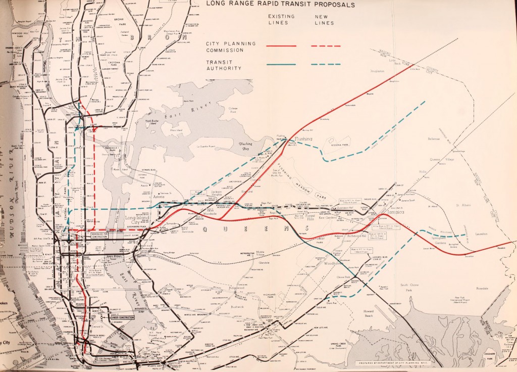
In my original futureNYCSubway plan I proposed a new trunk subway line under Northern Blvd in Queens from Long Island City to Flushing (with alternative routes along the LIRR Port Washington Branch or the Long Island Expressway) but I removed it from subsequent versions to focus more on improvements to the existing IND Queens Blvd Subway. With the 2nd Ave Subway being planned to have only 2 tracks this limits how many routes can run (2, efficiently) and thus limits one route along 2nd Ave to 125th St or the Bronx (the T train as planned) and one to Queens via the 63rd St tunnel (used by the F train currently). The Queens service train has not officially been planned even though a track connection will be built between the 2nd Ave Subway and 63rd St tunnel. One of the reasons that the MTA hasn’t brought up the 2nd Ave-Queens service (other than having no clear date or funding for construction of Phase 3 of the 2nd Ave Subway!) is that there is no place for it to go. The 63rd St tunnel was planned to connect to a superexpress subway line from LIC to Forest Hills running alongside the LIRR Main Line. At Forest Hills it would merge with the IND Queens Blvd subway to provide more express service to Jamaica and a planned but never completed subway extension to Laurelton, Queens. Due to a lack of funding this plan was dropped and the 63rd St tunnel was connected to the IND Queens Blvd Line between Queens Plaza and 36 St stations.
The big issue here is capacity and the fact that the subways in Queens and on the east side of Manhattan are all running at or above capacity. In the 1960s when many of these projects were being planned and designed the subways were already at capacity even though there was a loss of overall ridership. Planners noticed that riders would choose to stay on packed express trains even when a less crowded local train was in the station because they perceived the express as faster. The answer was to create express subways that would reach the growing neighborhoods in eastern Queens to relieve the existing subways in central and western Queens. Long Island Railroad service withing the city would be removed and replaced with these superexpress subways.
Today the subways are as congested as ever and the MTA is looking at a short term solution with Communication Based Train Control, a new signal system that is more accurate and will allow more trains to run. The MTA, having already installed this system along the L train and is in the process of installing it on the 7 train, recently announced that it will be installing CBTC on the Queens Blvd Line. Unfortunately, due to the configuration of the Queens Blvd Line, this won’t have as much of an impact of service as riders would hope. CBTC allows more trains to run along Queens Blvd but the trunk lines in Manhattan will still have the old signal system so they won’t be able to handle the new trains. This leaves the only option of restoring G train service to Forest Hills. While this will certainly help some riders it won’t do anything for the majority of riders looking to get to Manhattan.
The MTA needs to seriously look at new capacity in a bigger way then it has for the last 30 years. The last serious plan for system expansion was put out in 1968 and updated until the city hit its infamous fiscal crisis, after which the MTA decided to focus more on system restoration than expansion. While the MTA still has what the Citizens Budget Commission called a “Sisyphean” task they also have to face the fact that ridership is the highest its been since 1950, a date which sadly had more subway service than we have today (before they tore down many of the elevated subways). The CBC recommended that the MTA stop system expansion and focus on system preservation but unlike in the past where ridership was dropping the city can’t afford to cut back system expansion.

The only way to make a meaningful and substantial improvement to congestion in Queens is more subways.
Northern Boulevard Trunk Line and the 2nd Ave Subway
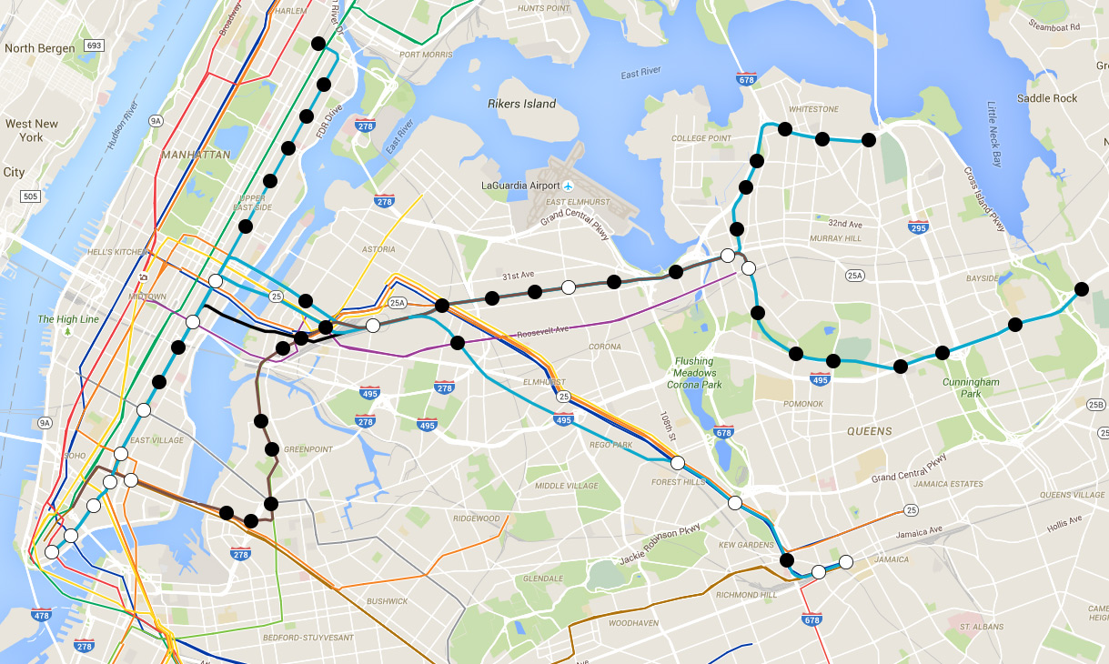
Looking back at plans from the 1970s the three major Queens subway proposals all expanded on the IND Queens Blvd Line, two I mentioned above and a third branch which ran along the Long Island Expressway. A subway is needed along the LIE corridor but it should take pressure off of existing subways not put more pressure on them. Looking at a population density map of Queens the densest areas are in the Jackson Heights/Corona area, downtown Flushing, central Jamaica, and along the LIE. A subway along the LIE is the most obvious answer but with the congestion along Queens Blvd a branch along the LIE would do more harm than good. A subway along the LIRR Port Washington Branch could offer a bypass but would then cut off service for riders in Nassau County. This leaves the Northern Blvd alignment as the best option as Norther Blvd is wide enough for a 4 track subway and would have an immediate impact on subway congestion at Jackson Heights for both the IND Queens Blvd Line and the IRT Flushing Line 7 train.
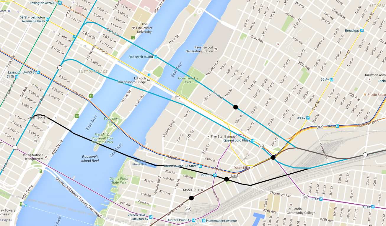
The first step in constructing a Northern Blvd subway would be expanding the 2nd Ave Subway south of 63rd St from the planned 2 tracks to 4. The 2nd Ave Subway as designed will relieve pressure on the Lexington Ave Subway, which is important, but it won’t add enough new capacity to help riders from Queens of Brooklyn. The two additional tracks would not connect to the 63rd St tunnel but would instead connect to a new 2 track tunnel located somewhere between 48th St and 57th St. A new tunnel would also allow for a future new crosstown subway in Midtown Manhattan should the need arise. Where the new East River tunnel is built will determine how it runs through Long Island City. If the tunnel is built at 48th St (in Manhattan) it should run close to Court Sq to allow for transfers to the E,M,G, and 7 trains. If the tunnel is built closer to 57th St then it should run to a point between the elevated Queensborough Plaza station and the underground Queens Plaza station to act as a new transfer between the two. Whichever alignment the new tunnel would run into the Sunnyside Yards where it would run along the LIRR/Amtrak tracks to reach Northern Blvd.
The new tunnel will be for Northern Blvd/2nd Ave express trains while Northern Blvd/2nd Ave express trains will use the 63rd St tunnel. Both tunnels would meet at a new station in Sunnyside Yards and continue as 4 tracks east under Northern Blvd. This would allow riders coming from 6th Ave or Jamaica the chance to easily transfer to the 2nd Ave Subway. Local trains would branch off in Flushing and run along the Whitestone Expressway and Cross Isle Parkway to Utopia Ave while express trains would turn south to run along the Kissena Park corridor and then along the LIE out to Douglaston. Running the new subways along existing expressways would allow them to be built for less or even built as modern elevated structures with a reduced impact on the surrounding areas.
Integrating Crosstown Lines
In a previous post I looked at different ways in which the IND Crosstown G Train could be expanded to better serve the system. As the only train that doesn’t enter Manhattan it is designed as a passenger distributor system so that a rider can transfer in Brooklyn and Queens to avoid congestion in Manhattan. This works in theory but not that well in practice. The system would work better if at each point along the line a rider had the option of taking a train to Manhattan or a crosstown train. Since the G train was designed to run along the local tracks of the IND Culver Line, which it shares with the F train, it is by default limited to 15 trains an hour (one train every 4 min tops). The NYC Subway is designed to run 30 trains per hour on one set of tracks which is why you usually only see 2 express and 2 local trains or less on lines (trains can run 3 services on one set of tracks but this causes delays). This means that the Crosstown Line could, for most of its route, handle an additional service to Manhattan if such a connection is built.
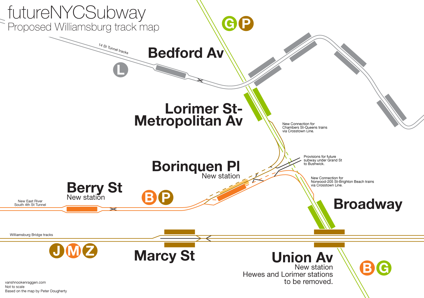
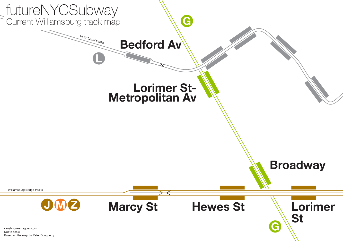
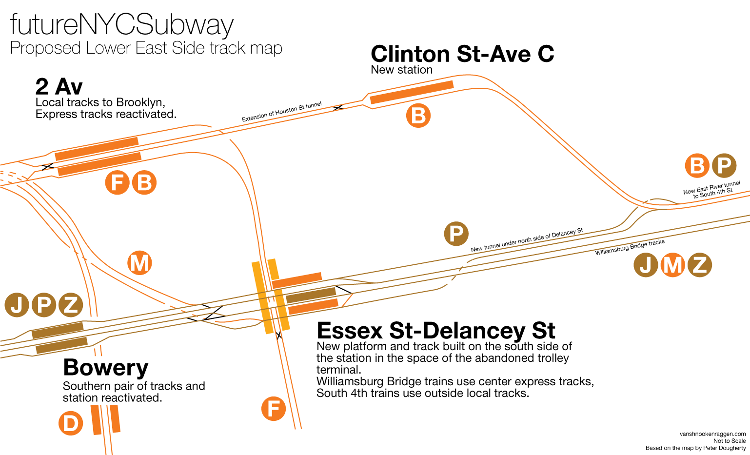
Such a connection should be built in Williamsburg. In my most recent version of the futureNYCSubway I proposed a modified South 4th St subway which would connect to the Crosstown Line and extend it south via Franklin Ave to connect with the Brighton Beach Line; sending the B via the G. This connection would use a new East River tunnel just north of the Williamsburg Bridge that on the Manhattan side would connect to the 6th Ave subway under E Houston St. On the Brooklyn side the tunnel would run under South 4th St and up Borinquen Pl where a new junction would be built to connect with the G train. This would give riders living along the G from Broadway station to Bedford-Nostrand station a one seat ride to Manhattan with an option for crosstown service.
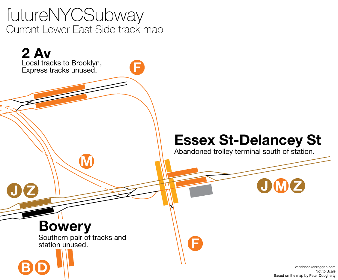
Taking this idea one step further you could build a second junction to head north to allow for a new train service to run from Manhattan up through Greenpoint and into Queens. On the Manhattan side there would be a new connection to the BMT Centre St Subway, the J/Z trains under Delancey St. Such a connection would require reconfiguring the Delancey St-Essex St subway station from 2 platforms with 3 tracks to 3 platforms with 4 tracks. The inner tracks would continue along the Williamsburg Bridge but the outer tracks (the existing northern Manhattan-bound track and the new southern Brooklyn-bound track) would tunnel under Delancey St along side of the Williamsburg Bridge and merge with the aforementioned East River tunnel. This would create a new line (P train) that would be a supplemental local service from Chambers St to Flushing via the new Northern Blvd Subway that would give Greenpoint riders a one seat ride into lower Manhattan, thus taking pressure off the L trian, or allow them to easily transfer to 6th Ave trains.
This would give riders in northern/central Queens and Flushing single seat rides to Midtown or lower Manhattan while reducing pressure on existing subways. Provisions would also be built for a new crosstown subway in Midtown, possibly to connect with the L train via a 10th Ave Subway, and a new spur to LaGuardia Airport.
Hey Vans,
Why there hasn’t been any recent discussions regarding a Northern Blvd Line by MTA or State and City officials is mind boggling. I submitted a comment on your v4 map thread with links to the latest reboot of my subway map and Staten Island Expansion Concept. Any comments or critiques would be greatly appreciated.
Steven
It seems like the comment on the aforementioned thread couldn’t be posted for whatever reason, so I’ll try to post it on this thread. I feel like my latest map is much more creative, yet I’ve maintained my cost effective approach. I like the idea of the T line expanding crosstown though 125 St, however I believe that having the Q replace the 3 in Harlem opens up a lot of options for the 3 to be extended into the Bronx and relieve pressure on the 2 and 5 lines. Also, I’m sticking to my guns in regards to my 8 line to Middle Village, which in conjuction with a Northern Blvd Line relieving overcrowding on the 7 line, would be an option that could greatly benefit riders in those neighborhoods. The links to my map and my Staten Island Expansion Concept are below. Again, any comments or critiques would be greatly welcomed and appreciated.
Steven
https://drive.google.com/file/d/0B4cdJBZQ7y80Z3hGS1FPUHhoU1k/view?usp=docslist_api
https://drive.google.com/file/d/0B4cdJBZQ7y80LTk5aW80czZUc2c/view?usp=docslist_api
Hey Steven, thanks for the updated map. Here are my thoughts:
– 3 Train: Sending the 3 train to the Bronx would be an excellent idea. The current interchange between the 2 and 5 train is really just an afterthought. Sending all Lexington Ave trains up to Woodlawn and all 7th Ave trains to Wakefield would simplify things and speed up service on both lines but it would require a transfer at 149th St. If the interchange could be rebuilt so that 3/4 trains go to Woodlawn and 2/5 trains go to Wakefield that would give the Bronx a very balanced service.
– Q to 148th St: The 2/3 trains are A Division and the Q is B Division; there is a physical difference between the two Divisions which means you can’t run service along the same tracks so connecting the Q to the 3 is useless. Also that means the IRT yards would be completely cut off from the 7th Ave/Wakefield Lines which would destroy service along both lines.
-7 Train and V train: As I think I mentioned in my last response branching the 7 train along Queens Blvd would be a terrible idea since the vast majority of ridership comes from Jackson Heights, Corona and Flushing. The Northern Blvd V train is needed just to bring ridership on the 7 train to a reasonable level; branching service that early would negate any impact the V train could possibly have. Also because the V train will be running along a 2 track 2nd Ave Subway and 2 track 63rd St tunnel; it can at most run 15 trains per hour (20 if CBTC is installed). That isn’t nearly enough to serve East Elmhurst and Flushing. Also think about extending the G to Flushing via the Northern Blvd Line. I still contend that extending the Myrtle Ave Line, the Z train in this case, to Jackson Heights would serve the same purpose without having to harm 7 train service.
-Utica Ave: You route both 2nd Ave trains along Fulton St in Brooklyn but it really doesn’t need that much extra service. Why not run the V train along South 4th-Utica Ave to act as an express train? Also, why do you have so many trains running out to Kings Plaza? Any single one of those would suffice, the area isn’t dense enough to need all three. Maybe extend the L train to Flatbush Ave-Brooklyn College instead.
-Staten Island: I like the idea of having a SIRR system out there but why switch the R for the Z to Bay Ridge? That would be massively unpopular as it would take away the one seat ride to Midtown for no good reason.
-Air train: Why run it to Hunts Point? I get that it would run along the Hell Gate Bridge but it would serve many more people at 125th St. At this point why not spend the extra money for the improved service. Also how do you run the Airtrain to Woodside? If you are following the BQE (which I assume is your design) then it would make more sense to used Jackson Heights-Roosevelt Ave as the terminal. I do think that Woodside is probably a better terminal since the LIRR is right there, just that it would be more expensive and intrusive to build than a terminal at Jackson Heights-Roosevelt Ave.
Thanks for taking the time to give your feedback, Vans. I really appreciate it.
– Q to148 St: What I’m proposing is a new tunnel that would run the Q below where current 2/3 lines run on Lenox Av after the 125 St extension. Therefore, at 135 St, riders would have to transfer to a platflorm below to take the Q. That tunnel would then be merged with the now former 3 line tunnel north of 135 St, and obviously the stations at 145 St(which currently only accommodates 5 cars) and 148 St would have to be modified. As for the cut off to the IRT yards, I’m not quite sure I follow you. The IRT yards that I’m aware of are at 207 St and in Brooklyn at Livonia. I’m not quite sure how 7th Ave/Wakefield Lines would be cut off as a result of running the Q to modified B division stations at 145 St &148 St. In my defense, I’ve only been buffing this stuff for the last 2 years. Your knowledge of the system and its history is far superior then mine. So you would have to further education me on this particular issue.
– 8 to Middle Village: There’s no denying that majority of ridership comes from Jackson Heights, Corona and Flushing areas, but that doesn’t mean all those riders live exactly in those specific areas. A great number of commuters in Middle Village, Maspeth and Elmhurst take buses to connect to subway stations along Queens Blvd. I think giving those commuters the option of a one seat subway line into midtown Manhattan as opposed to a daily bus to subway transfer commute would help a great deal. So, I respectfully disagree that it’s a bad idea in principal. Of course, this is all-inclusive with the addition of a Northern Blvd Line easing 7/8 line congestion. Adding a G line extension into Northern Blvd, as you suggest, could also be part of the inclusivity of these new Queens services. However, I do agree that perhaps extending the Z line to Jackson Hts would be a good alternative to this issue. Although, with a Z extension, those commuters wouldn’t have a one seat trip into midtown.
– Fulton Line: My old map did not include a 2nd Av V line, and the T was the local train terminating at Euclid Av, with the C running express with the A. I was content with that. But every rider I’ve talk to that commutes via the Fulton line has made it clear to me that 4 services (A,C,T,V) may be needed. As you see in my latest map the V only runs local service to Euclid on weekdays. Though, a reasonable alternative could be to run the V as a peak direction only service to Euclid Av in support of the C local during rush hours. But in either instance, the V would terminal at Hanover Sq during off hours. This is all assuming that the Hanover Sq station is constructed as a 3 track station, which it absolutely should be in order to leave the door open for future projects. However, this particular discussion could be mute if the Hanover Sq station is made with only two tracks.
– Utica Av: Truth is I have all these trains coming out of Kings Plaza solely because I think it looks cool on my map. I thought the idea of having a sort of second kind of Coney Island type terminal in Brooklyn with the IRT/IND/BMT all being represented would be eye catching. That’s not to say that the demographics of these neighborhoods (Flatlands, Bergen Beach, Mill Basin, Marine Park) won’t change in the future. Luxury skyscrapers are seemingly popping up everywhere not just in Manhattan’s west side. One could even argue that such a terminal could stimulate such demographic change. But yes, as of this moment, one of these would suffice. You’d go with an L train extension, I like the idea of running the M down Utica Av past Kings Hwy, then banking it east under Av H to connect to Flatbush Av/Brooklyn College.
– Staten Island: I have to be honest and say that I’ve gotten mixed reviews in regards to switching the R and Z lines. And quite honestly, I don’t think it’s that outrageous. Here’s why. First, cutting the R in Brooklyn and having it terminal at Whitehall makes it easier to add extended service to Queens. I respectfully disagree with people when they say that F express service isn’t needed past Forest Hills. Now I’m well aware that the current statistics dictate that. Although, much like a Culver line express, you would think it is needed by the way riders are constantly clamoring for it. Let’s say you live on or near Ave I. Obviously, you’d take the F at the Av I station. But, if the MTA provides express service along that line not only are you going to walk to the few extra blocks to 18 Av to catch the express service, your going to be more than happy to do so. The same would be the case for any example you wanted to use in Queens. This would change the ridership statistics all together. That’s why I believe those statistics don’t tell the whole story. If additional service is provided, I think you would actually see an overall increase in ridership at the express stations past Forest Hills. Second, with the N train would now be local in Brooklyn and essentially replace what was R train service through 59 St. Lastly, I don’t think it’s too much to ask for riders in Bay Ridge heading to midtown to make a cross platform transfer to a W express train at 59 St that would get them to the Flatiron district in 7 stops. Sure, riders along the stations below 59 St would lose that one seat trip, but despite the transfer they may actually save in trip time. Right now, its takes commuters from Bay Ridge 95 St, 24 stops and about 46 minutes in travel time to reach the Flatiron district on a one seat R train ride during rush hours. A Z train ride to from 95 St to 59 St would be 4 stops and take about 7 minutes. Allow 3 minutes at most (since the W’s terminal would be one stop away) for a cross platform transfer to a W train that’s making express stops in Brooklyn and going over the Manhattan Bridge. Trip time from 59 St to the Flatiron is about 27 minutes. We’re looking a total subway trip time of about 37 minutes. So, at 37 minutes, we’re potentially looking at a near 10 minute reduction in travel time by comparison. If you look at it from this perspective perhaps an R/Z switch wouldn’t be that unpopular after all. Thoughts?
– Air Train: Why run it to Hunts Point you ask? Metro North. But, running it from 125 St sounds like a cool idea, though I just can’t picture a terminal in that area. Where would it be? Triboro Plaza? And that would mean running it along the Triboro Bridge. No me gusta. Wouldn’t that be insanely more expensive than running it from Hunts Point or from Woodside via the BQE? I get that it would be a good transfer point with the Lexington Av lines/Q and T lines, but honestly, not a fan of the engineering logistics. Personally, I would be okay with it only running via Hunts Points, through Northern Astoria to connect with the N and keeping the 7 train or the Queens Blvd trains away from the Air train. A short extension to a terminal at Northern Blvd/62 St can be added later to connect with a Northern Blvd Line. I feel like that could be more than enough.
Anyways, once again, I appreciate you checking out my map and giving me very valuable feedback. Like I said, I’m still very much learning the system and its history. Your two latest posts were very informative and I enjoyed reading them. I’m glad I stumbled upon your awesome page.
Steven
I guess a lot of what you are describing wasn’t too clear on the map. The Q train makes sense but it would probably be cheaper just to run a shuttle from 135th St to 148th than build a new tunnel. I can’t imagine the ridership would ever be high enough to justify the cost.
I’m not saying there aren’t riders coming from buses in Middle Village, just that they are always going to be less than those coming from Jackson Heights, Corona, or Flushing. Part of the issue I have with your 8 train is that it would have to be elevated and would involve a rather elaborate and obtrusive elevated interchange above Queens Blvd. That alone is a deal killer. If the 7 was rebuilt as a 4 track subway then you could do so much more; branches to Middle Village, Flushing, and LaGuardia. Middle Village isn’t all that dense (compared to Jackson Heights) and its rather suburban nature means that it needs different transit options than just a one seat ride to midtown (not that it doesn’t also need that). I think that having the M train to Metropolitan Ave and extending it to Jackson Heights would suffice.
Bed Stuy is certainly growing so maybe 4 services would be needed by the time the 2nd Ave Subway opens up. I didn’t see that the V was rush, that seems reasonable. I don’t think the MTA has designs for the Hanover St terminal yet, though the last ones I’ve seen (which are probably 30 years old) have a bi-level terminal similar to the Archer Ave Subway. Flexibility will be important.
Utica Ave is one of those hard to pin down things. It needs a subway but there are no really affordable options. Southern Utica Ave, after Kings Highway, probably has a high water table and would require either an expensive subway or an elevated line… neither of which is appealing.
F Express: The problem is people don’t actually work like that. People think counter to what common sense would dictate, in this case they would certainly NOT walk a few extra blocks to get express service, rather they would transfer at the first express station because they would think “Express=faster/better” even when the times savings are minimal. The basic issue with F express is that the area through which the F runs has more subway service than it needs. The B/Q has a higher ridership because there are no subways to the east but the F runs between the D, N, and B/Q so the area is saturated and only gets more saturated as you approach Coney Island. Even extending the G won’t matter because most people would only wait for the F. The F will never need to run express south of Church Ave unless the other lines around there go down for some maintenance reason.
Staten Island R/Z: Bay Ridge riders would seriously disagree with you there. You advocate a one seat ride to Midtown for Middle Village but want to take it away from Bay Ridge? Riders don’t care about actual time savings, they care about perceived time savings. If you are at an express station and there are two trains, one is express and one is local, the express is full but the local has seats, MOST people will still get on the express because they think it will ultimately be faster. Anyway, the 4th Ave Subway is a tricky thing and trying to add more service, especially to Staten Island, would mean taking away express service for existing passengers. The only real way to add a SI train would be to extend a reactivated W train from Whitehall to 59th St, moving the D to the local tracks and running the W express. This would pretty much be the only way to add a new service that would adequately serve SI (another alternative would be the run the D train to SI with the W taking over along the West End Line)
AirTrain: Obviously running it to Hunts Point would be cheaper but it would cut off a lot of travelers from upstate using MetroNorth. 125th is better even given the extra cost. The engineering is nothing, a simple viaduct and a couple bridges. Hell, if you are extending the T train under 125th why not just build a second track for it? The engineering is simple, the cost is high, but the cost might be worth it given how many more riders it would serve. Also a Triboro subway line might not have the ridership for the MTA to consider building a new subway line but the AirTrain is financed and run separately so it would make up the cost of construction on the long end.
A shuttle to 148 St would probably suffice, but I’ll keep the Q to 148 St for now. After all, whole point is to free up the 3 regardless. So in hindsight, do you think it was a mistake for the MTA to extend the 3 to 148 St to begin with?
I’ve already scrapped the 8 to Middle Village in the latest map I’m currently working on, and replaced it with a shuttle to Jackson Hts. That would probably be the best and most cost effective way to connect Queens services between Middle Village and Jackson Hts.
I had the M terminating at Kings Hwy in the previous map, but never thought about the idea of running a Utica Av express. Not only would it be costly, but also wouldn’t exactly be the easiest engineering endeavor. Stuyvesant Av is too narrow to run three or four tracks on one level, so the express would obviously run underneath. But, because I consider the Utica Av Line to be of high priority, I’ve started to mess around with service options for the V on my next map. I’m also flirting with the ideas of either sending the G up Northern Blvd to Flushing and College Pt to support the V or rerouting the F as an express Northern Blvd service (the M would replace the F express service to Jamaica and the G would run local to Forest Hills during the week like back in the day).
I agree with everything you said with regards to the F express in general. And, I even think I mentioned that the numbers don’t call for an extra service. However, I must disagree with you that ppl would NOT walk the extra blocks simply because the example I gave you wasn’t something I made up to justify my position, but an example given to me by someone who rides the F into the city. Every time I discuss transit with Brooklynites, the F express is one of the first topics that comes up. Bottom line, I find that people seem to want that service restored. Which is really strange considering that it was originally removed cause it was so unpopular back in the day. It’s like J/Z skip stop service. I personally don’t think it’s needed cause the numbers dictate to me the one service along the Nassau Line would suffice. But I think riders would go ape shit if the MTA removed it. Sometimes it’s about giving the paying customer what they want and I feel like I’m giving the people what they want by including it in my maps. If nothing else, I think the idea of restoring the F express simply to get the F off the same track as the G to relive train congestion during the rush seems reasonable.
Like I mentioned before, I’ve gotten mixed reviews (pretty much a 50/50 split), regarding the R/Z switch. Though, when I explain my reasoning to those that don’t like the idea, some end up agreeing that having to do a simple cross platform transfer (3 options: 59 St, 36 St, Barclays) is not the end of the world and they realize they’d be actually saving trip time. And, I actually found that many riders traveling to midtown from Bay Ridge are indifferent to the idea of a switch, because they end up transferring to an express along 4th Av the first chance they get anyway. So because of that, saying that it would be vastly unpopular, I feel, is a bit of an exaggeration. I’ll tell what is vastly unpopular with Brooklyn riders based on my research…The R train in general. That’s cause the R is overworked and stretched out to far, and riders educated about the system know it cause it’s reflected in the service on a daily basis (45 stops, 3 boroughs, full local). It’s also not the most popular route with operators and conductors either.
Although I think an Airtrain terminal at 125 St would be a bit obtrusive for that area, I’m all for any Airtrain options that aren’t the one that’s currently proposed at the moment. An Airtrain from Willets Pt would be a straight up nightmare. I just believe that since there’s currently a proposal to expand Metro North to Hunts Pt, that could be the best option. A terminal wouldn’t be obtrusive and costs wouldn’t be unreasonable in comparison to the current proposal (450 million from Willets).
Hey Vanshnookenraggen!
May, you be able to take a minute to look a minute at my map that I have created my own on the future of the NYC Subway System (some of these ideas were inspired off of you)
https://www.google.com/maps/@40.7162485,-73.9113992,13z/data=!4m2!6m1!1szaGfw8DivW50.kI73-1rRulrQ?hl=en
Thomas, change the sharing settings of that map to Public so I can see it.
Hi Thomas, thanks for this. Here are my initial thoughts:
– I love the idea of your 34th St-Northern Blvd Line. Seems to me you would be able to have a branch or two once you get to Flushing.
– Your extension of the N train to LaGuardia is needlessly convoluted. Running the line along the route you drew would draw more NIMBY resistance, running it through ConEd territory would be simpler, cheaper, and more feasible.
– The 7 train through the West Village might have worked had the High Line never been partially demolished or turned into a park but at this point there is no need and no real way to do that. The area is wayyyyyyyy to high end these days to even need a subway; everyone over there takes cabs (gross generalization I know).
– The way you connect the Concourse Line to Gun Hill Rd wouldn’t actually work given how the tunnel itself at 205th St is constructed. It was designed to run through Bronx Park, above ground on a bridge, to Burke Ave. While Gun Hill Rd makes a whole lot more sense it would be flat out cheaper and just as effective to build it to Burke Ave. Also you probably don’t need to run it all the way to the Hutchinson River Parkway, a large terminal/park-and-ride at Coop City Blvd would suffice.
– Additionally splitting the 2nd Ave trains (T/P) in the Bronx would be cutting service too much (unless you are suggesting a second set of express tracks under 2nd Ave be built). 2nd Ave Subway can, as designed, run 30 trains per hour. If the Q takes half of that then that leaves 15 for the T/P which would then run 7 trains max to Dyre Ave or Lafayette Ave. That isn’t nearly enough to justify building a new subway along Lafayette Ave.
– Utica Ave: I like how you extended the W train out there and terminated the M at Kings Highway. That is something I hadn’t thought to do but would probably be a better service plan.
Overall I love what you’ve done here. Anything else I didn’t mention I think is a a good addition to the subway. Definitely look at improved subway access to eastern Queens more.
Fixed It!
Alright thanks for the advice! I would’ve extended into Queens more but seeing how MTA’s budget for things are currently I thought that Queens can be a part of the system that over time can be extended farther.
I thought that that for the Second Avenue Subway in terms i’m hoping phase 3 and phase 4 come with express tracks because I thought of a Queens Second Avenue Subway and with that line using the 63rd Street tubes I was thinking there would be express tracks from 61st Street (to let the line connect to the Second Avenue Subway first) all the way to Grand Street.