
In the previous post I outlined the history of the many plans to connect Staten Island to the rest of New York City via a rail tunnel. While most people assume that a tunnel would be too expensive to justify, I wanted to explore the possibilities.
A note: all costs which will be discussed are not to be taken as dogma. They are based on the real costs associated with the 2nd Ave Subway, but are not a 1:1 ratio and do not reflect the specific challenges with underwater tunneling. They are there purely for comparison and understanding.
Understanding how Staten Island commutes
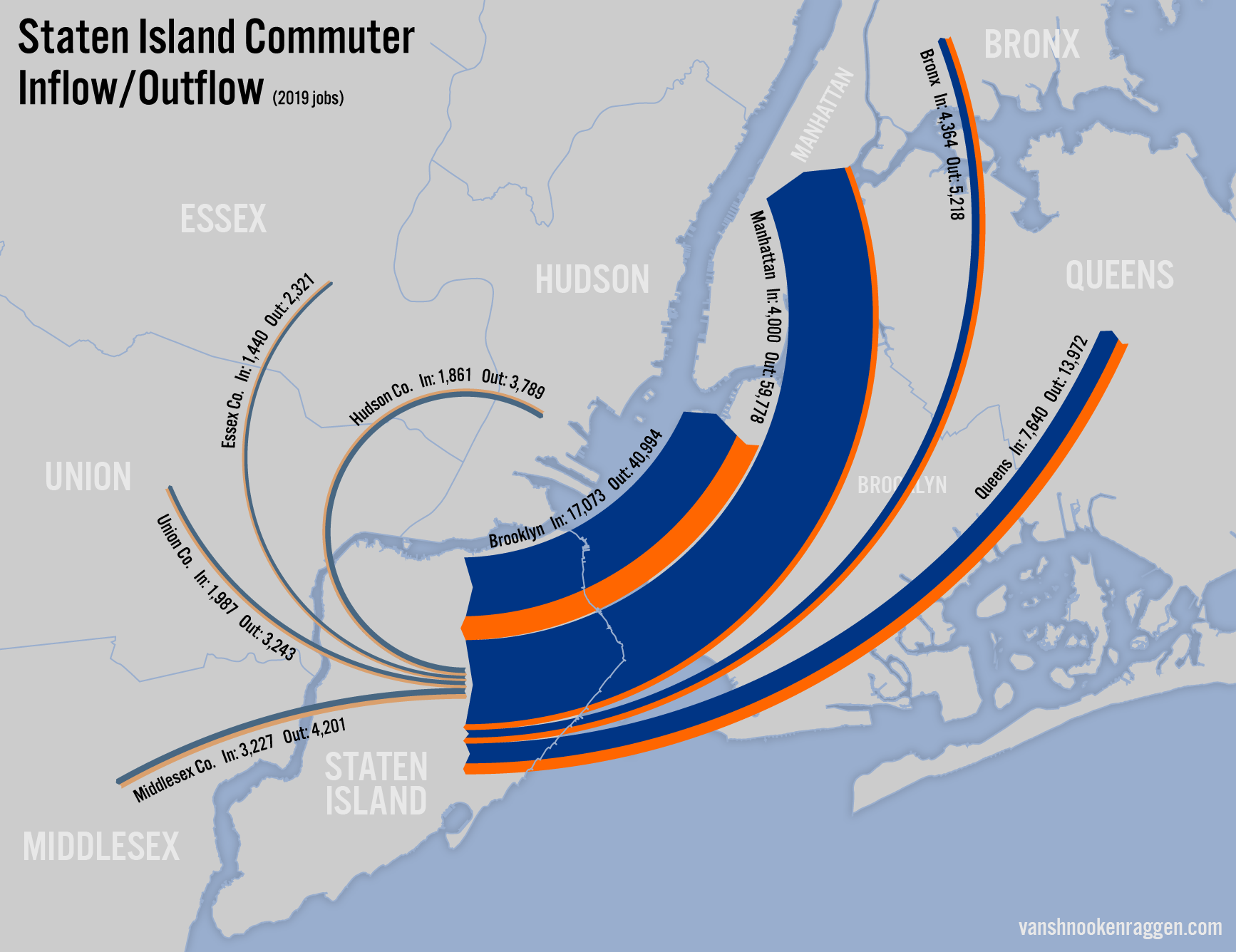
The 2020 census showed that Staten Island was home to 495,747 people. Employment figures (the most up-to-date numbers are from 2019) show Staten Island is home to 121,120 workers who live and work on the island. On the island, the majority of jobs are in Health Care and Social Assistance (30,723), followed by Retail (14,389), Education (14,106), and Construction (10,494).

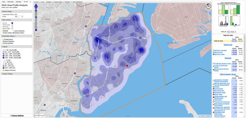
Using OnTheMap we can see where most jobs are clustered: St. George, Old Place (where a number of Amazon warehouses have opened over the last decade), Staten Island University Hospital in Dongan Hills, the Staten Island Mall in New Springfield, the Richmond University Medical Center in West New Brighton, a cluster of industrial jobs along the North Shore, and a number of retail strips throughout the island.
The island has one rail line, the 14mi long Staten Island Railway (SIR). In 2018 the MTA claimed a ridership of 4.6m riders. To put that into perspective, that would be a relatively busy bus line in any of the other boroughs. This number is an estimate due to the fact that many of the stations do not have fare gates. In fact, fares are only collected at St. George and Tompkinsville; all other stations are free.
The SIR once had two additional branches which were abandoned after World War II. The South Beach Branch was since been redeveloped, but the North Shore Branch still has much of the right-of-way intact (though, as will be discussed, not all of it remains.) The North Shore Branch was the only direct connection to the main land via the Arthur Kill lift bridge. The bridge is still active and serves the New York Container Terminal at the northwest corner of the island.
Off Island Commuting
If anyone is interested, I have created a Flickr gallery showing the data gathered from OnTheMap for all commutes on and off the island.
| Manhattan | Hudson Co. | ||
| In | 4,000 | In | 1,861 |
| Out | 59,788 | Out | 3,789 |
| Brooklyn | Essex Co. | ||
| In | 17,073 | In | 1,440 |
| Out | 40,994 | Out | 2,321 |
| Bronx | Union Co. | ||
| In | 4,364 | In | 1,987 |
| Out | 5,218 | Out | 3,243 |
| Queens | Middlesex Co. | ||
| In | 7,640 | In | 3,227 |
| Out | 13,972 | Out | 4,201 |
| NYC Total | NJ Total | ||
| In | 32,177 | In | 8,515 |
| Out | 119,962 | Out | 23,554 |
Most workers who live on Staten Island work off of the island. For purposes of this evaluation I’ve decided to only look at commuters going to the other four boroughs and the closest counties in New Jersey. The outflow (commuters from SI) and inflow (commuters to SI) are shown above and listed to the right (2019 numbers).
Since Staten Island once had direct commuter rail access to NJ, many planners have proposed rebuilding this connection. A separate idea to extend the Hudson Bergen Light Rail over the Bayonne Bridge has been proposed. But what these numbers show is that if we are going to make the investment of connecting Staten Island to the city with rail, it must go directly to New York City and not through NJ.
Staten Island is connected to the rest of New York City via the Verrazzano Narrows Bridge and the Staten Island Ferry to South Ferry at the tip of Lower Manhattan. The ferry serves only passengers, 24 hours a day, 7 days a week; it is free. The Verrazzano Bridge has two decks with 13 lanes total, one being a dedicated bus/HOV lane and another being a flexible, part-time bus/HOV lane; the bridge has different levels of tolls which range from $10.17 to $2.75 for residents. As I explained in my previous post, the bridge was not built to allow the addition of rail tracks.
The Verrazzano Bridge opened in 1964 and spurred development on the island. This development was mostly suburban in nature, requiring a car to get around. So while most commuters work in the typical business districts within the city (e.g. Midtown, Financial District, downtown Brooklyn), drivers are able to work in a variety of different locations not dependent on transit.
That said, Staten Island does have local and express bus service that covers the island and reaches into Brooklyn and Manhattan. The five most heavily used bus lines are the S79 SBS (which runs from the Staten Island Mall to Hylan Blvd and then north to 86th St in Bay Ridge), the S53 (which runs from Port Richmond on the North Shore to 86th St in Bay Ridge), the S48/98 (which runs from Arlington to St. George along Forest Ave), the S46/96 (which runs between Chelsea and St. George through the North Shore along Castleton Ave), and the S44/94 (which runs between the Staten Island Mall and St. George through the North Shore).
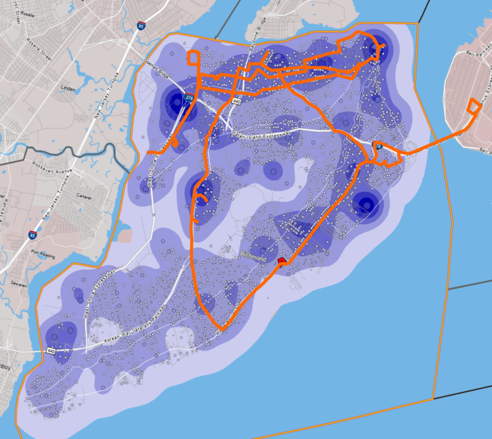
Looking at the major job centers on Staten Island with the top 5 bus lines on the island it becomes quite clear that the majority of the ridership is between locations on the North Shore and to the two closest transit centers connecting to the rest of the city, namely St. George Ferry Terminal and the 86th St station of the R train in Bay Ridge.
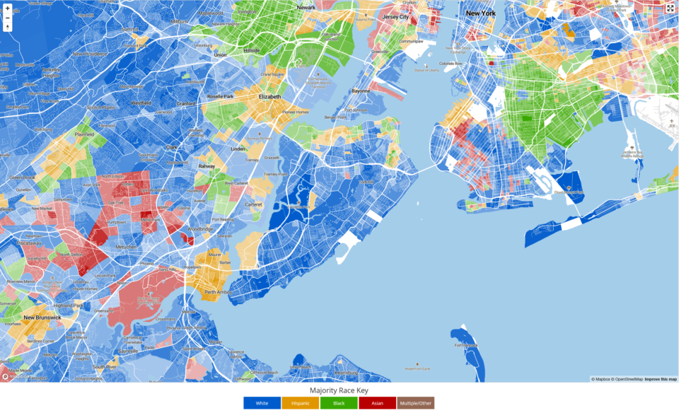
This map also closely corresponds to the racial and economic layout of Staten Island. The North Shore is home to a majority black and Hispanic population, has a lower Median Household Income than the rest of the island, and typical votes more Democratic than the rest of the island, which tends to be more Republican. These trends also lend themselves to higher transit usage/lower car ownership.
When considering where a new tunnel should go once it reaches the rest of New York City, we should take a closer look at the job centers off the island. Looking at the map we see the usual suspects: the Financial District, Midtown, and downtown Brooklyn. As an aside, the large concentration seen in downtown Brooklyn is a data anomaly. The Dept. of Education registers all teachers at their MetroTech location even though teachers are employed at schools throughout their respective boroughs. So while downtown Brooklyn does have a good share of jobs, this one cluster must be ignored.
What is important to note are the job clusters outside of the Central Business Districts, especially in Brooklyn and Queens. Areas of note include Sunset Park, Brooklyn’s Chinatown, Sheepshead Bay, a retail cluster along Kings Highway in Midwood, the hospitals located in East Flatbush (Downstate, Kings Co., and Kingsbrook), NY Presbyterian Hospital in Park Slope, a small cluster in the Hasidic Jewish community of Williamsburg, LaGuardia College in LIC, Rikers Island, downtown Flushing, and various retail clusters in Forest Hills.
I have prioritized a One-Seat-Ride when looking at jobs numbers (and potential ridership), but it is important to consider that many riders will be transferring from their initial subway line to another one serving these outer borough jobs. Therefore, it’s important that any subway line chosen has a high transfer availability.
Alternatives Not Considered
Before we begin, I want to address some potential alternatives which I see time and time again.
The first is a connection to New Jersey. The numbers clearly show that the majority of commuters off the island are headed to the other four boroughs. This means that I am going to focus this evaluation exclusively on transit tunnels to Brooklyn and Manhattan. I do believe that some kind of train connection to NJ is worthwhile, possibly the Hudson Bergen Light Rail connection, but that is worth a study on its own (which I’m not planning on doing!)
Second, the first thing that always comes up when discussing new rail transit on Staten Island is reactivating the North Shore Branch, which has sat abandoned since 1953. The MTA, in fits and starts, has been working on an evaluation of the line. The current thinking is that it could be used as a Bus Rapid Transit (BRT) trunk line. Given the higher bus ridership through the North Shore to St. George I’d argue that this is probably the best and most realistic option.
:format(webp)/cdn.vox-cdn.com/uploads/chorus_image/image/65700245/01_Kensinger_North_Shore_Staten_DSC_3097.0.jpg)
But the idea that we should rebuild rail along this right-of-way is wrong and ignores the overall shortcomings of the route. As outlined in this great piece on Curbed from 2019, reactivating the line has some serious challenges. These include the fact that the very land on which parts of the line was built has been eroded by the sea. The line runs through industrial private property still in use. Running so close to the water, half of the catchment area of the transit line would be, in fact, water.
So I am stating here, once and for all, the North Shore Branch should not be rebuilt as a rail or subway line. If we are going to build something new then it must run further inland where there is much easier access and higher ridership potential. Not to mention, less susceptible to flooding. A BRT roadway could double as a seawall and would be easier to maintain than a railroad.
Lastly, as I discussed in my last post, extending rail over the Verrazzano Narrows Bridge is a non-starter. If the bridge was not engineered in a way which would support the additional weight of trains and their tracks, then it might not even be possible to retrofit the bridge for such a purpose. Not to mention, the connection on the Brooklyn side would require rebuilding the approach ramps and extending the subway along the approach highway in some form. Since it’s probably infeasible, I’m not considering it.
Alternatives Considered
When considering a potential tunnel between Staten Island and Brooklyn or Manhattan we need to understand which lines it could connect to in Brooklyn. The two subway trunk lines which run closest to the harbor are the BMT 4th Ave Line and the IND Culver Line. Both are 4-track trunks that do not run at their full capacity, but with extensions of existing service could serve a new tunnel.
There is also the proposed Interborough Express (formerly Triboro RX) which is proposed to run along the LIRR Bay Ridge Branch. For purposes of this evaluation I will assume that it does get built from Bay Ridge to Jackson Heights (let’s be real, if it any of this gets built, the IBX will certainly open will before a tunnel to Staten Island will.)
I am also considering a tunnel directly to Manhattan. I’ve seen a number of fantasy maps which includes such a tunnel as part of a greater Regional Rail build out. But I am only going to consider a direct subway tunnel connecting to the existing network as anything more complex would require billions more.
In order to compare travel times, I am using two control points. In Staten Island I am measuring travel from the Grasmere Station, and in Manhattan I am using 34th St.
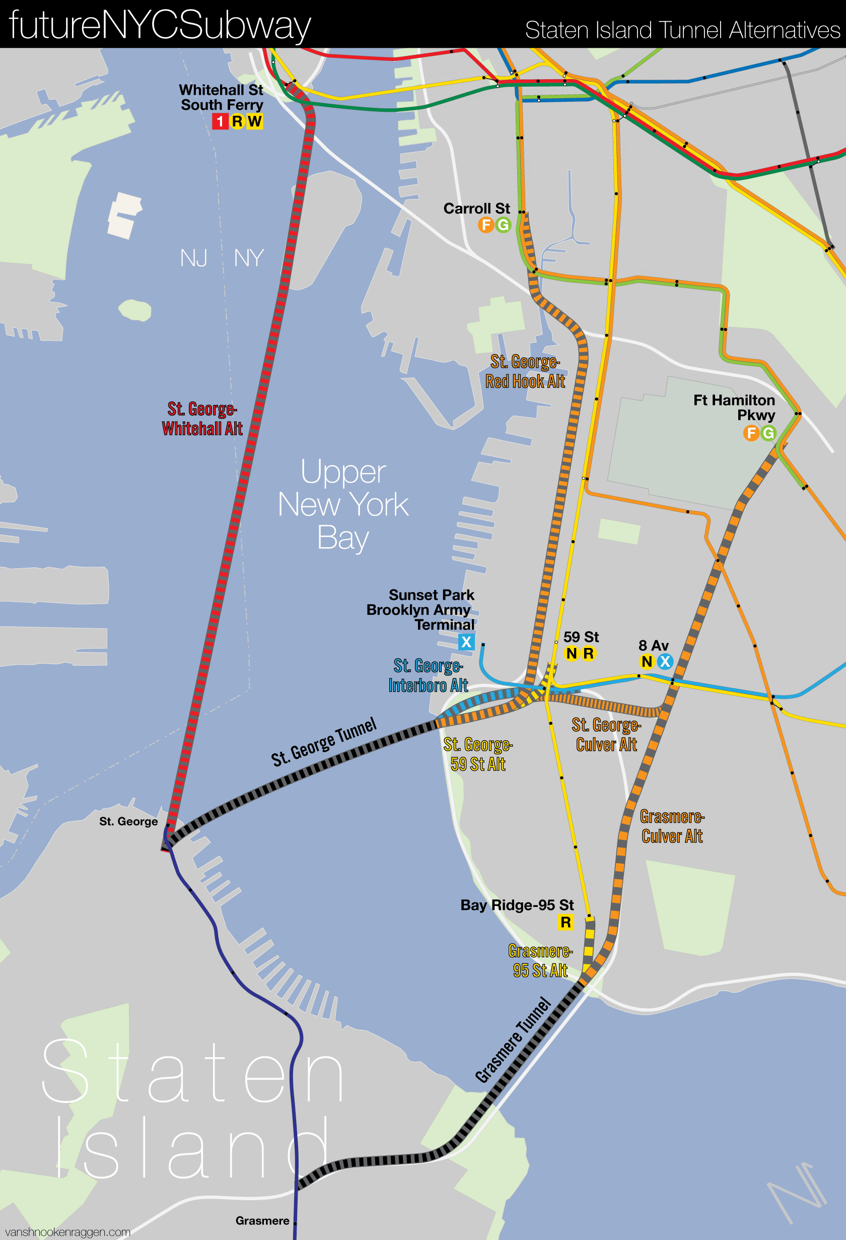
There are two locations where a new tunnel could be located at in Staten Island: St. George and parallel to the Verrazzano Bridge to the neighborhood of Grasmere. In terms of just the underwater crossing, the St. George alternative is about 2 miles while the Grasmere alternative is just over 1 mile. The St. George alternative has the advantage of serving the ferry terminal hub, which has access to the SIR and numerous bus lines. The Grasmere alternative would require a subway line built further inland, along the Staten Island Expressway, to a station at the SIR north of Grasmere Station. There are 5 St. George alternatives and 3 Grasmere alternatives.
In order to properly compare each alternative I will look at the length of the new tunnel, the maximum levels of service which could be run through the new tunnel using the existing system, total travel time from the control point in Staten Island, Grasmere Station, to the control point in Manhattan, 34th St, if the line creates a one seat ride to Manhattan, jobs along each route, the cost per mile, and finally the cost per rider. I’ve created a metric which ranks each alternative (the lower, the better).
Judging Costs
In case anyone has ever wondered, I am not an engineer. I can only hypothesize based on existing projects what a project might cost. While it is well known that NYC has the highest subway construction costs in the world, just basing a project off of the final costs of the 2nd Ave Subway doesn’t work.
2nd Ave had ridiculous costs for a variety of reasons. A major factor was that it was being built in a complex built environment. A tunnel from Brooklyn to Staten Island isn’t going to have to deal with such high real estate acquisition costs, nor would it have to deal with complex utility relocation (some, but not nearly as much.) There is more room for staging on both sides of the water and construction can be done with more flexibility than under 2nd Ave.
Because the MTA received federal DOT money to build the 2nd Ave Subway, it had to send periodic reports back to the DOT. In these reports they break down their costs (although not as much as I’d like). Using these breakdowns, we can create a somewhat more specific model for potential costs (adjusted for inflation.)
I need to stress that any cost that I present is a very general guess based off of assumptions made on 2nd Ave Subway costs (they are not 1:1). The last underwater tunnel built in NYC was the 63rd St Tunnel, which was built with pre-cast sections. A tunnel to Staten Island could be built that way, but since I only have access to TBM costs, I have to use those. TBMs would still be used for tunneling on both the Brooklyn and Staten Island sides, so it would make sense to assume the entire project would be built using this technology.
Today, Amtrak is moving forward on the Gateway Tunnel and the PANYNJ and MTA are moving forward on a Tier 2 EIS for the Cross Harbor Tunnel. Once those reports are released I will have a better idea of what current underwater tunnels would cost, and may well go back and update this proposal.
While the costs I am using are based on 2nd Ave costs, I’ve tried to cut out certain elements, and their costs, based on the change in conditions. This is more art than science, but should help us get to the right ballpark.
Typically, costs are broken down between “hard” and “soft” costs. Hard costs are how much the construction materials cost. Soft costs are what we pay contractors for labor, professional services (like architects, engineers and project managers), and contingency for inflation or cost overruns. Soft costs are more nebulous and can’t be known until a project is actually being planned. For the 2nd Ave Subway, soft costs were about 38% of the total hard costs. I’ll add the soft costs in at the end when both tunnel and subway are added.
Lastly, I am not here to propose cost controls. I am not going to compare these costs with other cities or nations as I feel that it would unfairly ignore the reasons costs are so high here to begin with.
Ridership
Ridership forecasting is always more art than science. For this project I looked at the total number of jobs along a route (1/2 mile away). Obviously, not every single worker would take mass transit. But also, not everyone taking mass transit would be doing so just for work. So without access to more sophisticated software, I’m going to call it a wash and use the job numbers as a simple way to see who might take mass transit in total.
Alternatives Chart
| Tunnel | New Tunnel Length (Miles) | Train Service | Max TPH | Travel Time (Grasmere-34th St) Min | New Stations | Construction Cost | Jobs Along Route | Cost Per Rider | Total Metric |
| Control: SIR-Whitehall Ferry (No Tunnel) | X | SIR, Ferry, Broadway Line | 9tph+3fph+18tph | 77min | 0 | 0 | X | X | X |
| St George-59th St/4th Ave Local | 2.9mi | W | 8 | 58min | 1 | $1,817,108,187 | 63,105 | $28,795 | 3.72 |
| St George-Culver | 5.7mi | F | 15 | 49min | 4 | $4,576,486,672 | 52,843 | $86,605 | 7.07 |
| St George-Red Hook | 6.2mi | F | 15 | 39min | 2 | $3,816,721,193 | 51,052 | $74,761 | 7.67 |
| St George-Whitehall | 5.6mi | W | 8 | 36min | 2 | $3,542,963,965 | 50,296 | $70,442 | 6.52 |
| St George-Interborough Express | 3.5mi | IBX, N | 10 | 51min | 1 | $2,090,865,416 | 53,072 | $39,397 | 4.63 |
| Grasmere-95th St/4th Ave Local | 2.9mi | R, W | 18 | 56min | 2 | $2,311,056,438 | 65,652 | $35,202 | 2.10 |
| Grasmere-Culver | 6.7mi | F | 15 | 43min | 5 | $5,526,696,970 | 51,974 | $106,336 | 9.89 |
| Grasmere-95th St/4th Ave Local-Express | 2.9mi | B | 15 | 47min | 2 | $2,311,056,438 | 51,882 | $44,544 | 3.79 |
Control: Staten Island Railway to the Staten Island Ferry to R/W train
The current route takes about 77 min to get from Grasmere Station to 34th St with two transfers.
St. George to 59th St
This is a variation of the original plan for the Staten Island Subway extension. The 59th St station on the BMT 4th Ave Line was built with provisions to connect the tunnel to the outside, local tracks. This version would not include the large wye track which was part of the original proposal (for future connections to the North Shore Branch and Main Line) as it would serve St. George directly. Service would be provided by an extended W train.
While all travel times considered beat the existing ferry-subway option, this alternative has the longest travel times of all options considered due to the fact that the W train would run local the entire way. Riders would most likely transfer to an express train at 59th St or 36th St. This may cause overcrowding on existing lines, as well as contribute to system delays as trains would have to wait in the station longer for passengers to transfer (as is common at Roosevelt Ave station on the E/F/M/R lines.)
A downside to this alternative is that it would permanently split service on the 4th Ave Local tracks between Staten Island and Bay Ridge. Any service changes that would be needed on one branch would directly affect the other. If, say, ridership on the Staten Island branch required more service, this would come at the cost of reducing service to Bay Ridge.
This alternative has the 2nd best metric at 3.72. St. George is a major transit hub and job center unto itself. It has the lowest cost-per-rider at $28,795 and would be the cheapest construction option at $1.8 billion.
St. George to Culver
In 1939, the IND proposed a second concept for a subway tunnel to Staten Island. The IND South Brooklyn Line (which today is referred to as the Culver Line, F/G trains) was built with 4-tracks so that it could provide express service to Coney Island. Ridership on the line never met expectations, so planners were looking for ways to utilize the extra capacity.
They proposed a branch off of the IND South Brooklyn Line at Ft. Hamilton Pkwy. Details are limited, but from the map it appears that the line would have three branches, one to Fort Hamilton in Brooklyn and two to Staten Island. While it is unknown exactly how the service would have been split, if we were to simplify the proposal today we could imagine that the F would be rerouted to Staten Island and the G extended to Coney Island.
The new tunnel would begin at Ft. Hamilton Pkwy and East 5th St in Windsor Terrace. The express tracks were built below the local tracks so that they could take a straighter path between 7th Ave and Church Ave stations. The Staten Island Tunnel would connect only to the express tracks and run straight down Ft. Hamilton Pkwy to 67th St where it would turn towards the harbor and follow the identical path of the other St. George Tunnels. Being a much longer extension, this alternative would include three stations for transfers: 4th Ave, Ft. Hamilton Pkwy/60th St, and New Utrecht Ave.
Using the F train would provide higher levels of service than the W on 4th Ave. Travel time would be faster as the line would run express at all times through Brooklyn; 49 mins to 34th St. But the costs would be the second highest of the options considered. Unlike simple underwater tunnels, this would be a major subway extension with new stations built to connect to existing lines.
The added complexity to the project would give this option a metric of 7.07, with a cost-per-rider of $86,605 (the second highest), and an overall cost of $4.57 billion (second highest).
St. George to Red Hook
While I have not seen much written about it, nor do I have a proper source, at one point after World War II a Brooklyn politician proposed a variation of the IND tunnel which would still use the underutilized express tracks, but be built with a shorter and straighter tunnel. This new tunnel would run from the IND Culver Line express tracks at Carroll St station, under the Gowanus Canal, and along a new tunnel through Sunset Park (here I suggest using 3rd Ave), before crossing over to St. George.
It’s worth considering this alternative as it cuts out a lot of the unnecessary expense of the original IND plan. It would, unfortunately do more harm than good as it would divert F trains away from Park Slope which would now only be served by the G. The benefits would be a much faster travel time, 39 mins, and a new station in Sunset Park which would directly serve the growing Industry City. While it would directly serve Sunset Park and allow for transfers to other trains in downtown Brooklyn, it would still have fewer connections than the previous alternative.
This alternative scores a metric of 7.67. Due to the added complexity of tunneling through Sunset Park and having an intermediate station, the cost-per-rider would be $74,761 and an overall cost of $3.8 billion.
St. George to Whitehall
A tunnel directly from Whitehall, or South Ferry, to St. George would be the second-longest underwater tunnel built in the US, and the longest built only for rail (in the US). To make things a bit simpler, I would propose that any serious proposal for such a tunnel would make a stop on Governors Island first. Not so much that a station there would generate ridership, but so that an emergency exit could be built closer to the midsection of the tunnel.
At 5.6 miles, the tunnel would need some serious safety precautions. Taking a page from the Channel Tunnel between the UK and France, there would need to be three tubes, two for rail and one as an emergency escape.
A direct tunnel would be the fastest, at 36 min. But it wouldn’t serve Brooklyn directly. This would force many riders to double back, increasing outer borough trip times.
There are two subway lines which terminate at the tip of Lower Manhattan, the W and 1 trains. Both serve similar areas or have enough connections to other lines that potential ridership would be a wash. Where one outshines the other is in service frequency. The W is limited by the R and can only provide 8tph. The 1, on the other hand, does not interline with any other service, so it could see much higher frequency, so I’ve chosen to use the 1 train.
This proposal ranks somewhere in the middle with a metric of 6.52. Cost-per-rider would be $70,442 with an overall cost at $3.5 billion, although given the length of the tunnel I believe it would cost much higher due to added safety features.
St. George to Interborough Express
The Interborough Express (IBX) is a new proposal from Governor Kathy Hochul to add passenger service along the LIRR Bay Ridge Branch, currently used for a few freight trips a day. The proposal is a watered down version of the Triboro RX plan which was first proposed by the Regional Plan Assn. back in 1996 (their concept has evolved over time as well.) Under the current plan, passenger service will run from Bay Ridge (starting point unknown, but it is presumed to be near the Brooklyn Army Terminal) to Roosevelt Ave in Jackson Heights.
In the past, planners have suggested that this line could be extended to Staten Island, near St. George. A circumferential line connecting all four of the outer boroughs would be a dream. However, there are some serious issues when one looks at the plan in detail.
The connection to the Bronx was dropped (no longer making the line a tri-borough line) due to a sketchy excuse about not being able to mix IBX, freight, Metro North, and Amtrak over the Hell Gate Bridge. There is also the issue about service type. The MTA’s EIS will only look at heavy rail, light rail, and BRT. It will not study if the IBX could be built as a subway (as defined by the FRA). It will most likely be built as heavy rail and run as a LIRR line (this is purely my speculation but one based on the needs of the active freight along the line, as well as the fact that most of the line is owned by the LIRR already.)
This makes extending the IBX to Staten Island more complex and possibly less useful. No direct access to the subway would be made and passengers would need to transfer at either 4th Ave to the R (which will be a few blocks away) or 8th Ave to the N. This transfer would add significant travel time, with up to 51 min in total.
While it would not provide a One-Seat-Ride to Manhattan, it would provide service along the IBX deeper into Brooklyn and Queens. The problem is that while the number of commuters making these tips are not 0, they are certainly nowhere near the majority. As such, most riders would need to transfer, causing congestion and delays.
A silver lining might be that, as an FRA designated heavy rail tunnel, the Bay Ridge Branch might then be connected to the national freight network via a new line through Staten Island or connection to Bayonne. It’s unfortunate that this is not being considered by the Port Authority for their Cross Harbor Tunnel. No doubt the extra costs of tunneling through Staten Island as opposed to Jersey City (which is the current plan) prevent this plan from ever being taken seriously.
Without taking into account the extra costs of building the IBX in the first place, nor the costs of the tunnel on the Staten Island side, this alternative by itself scores a metric of 4.63. Cost-per-rider would be $39,397, with an overall cost of $2.09 billion.
If built, it would be more of an excuse to extend the IBX rather than building a tunnel that is useful.
Grasmere-95th St
The Grasmere alternatives would be extended from the southern tip of Brooklyn to Fort Wadsworth in Staten Island, then along a new line parallel to the Staten Island Expressway. This would be a combination of tunnel and viaduct along the expressway. For all alternatives, there would be at least two new stations on Staten Island, one at the SIR (where a new North Grasmere Station would be built to facilitate transfers) and one at either Fingerboard Rd or Lilly Pond Ave.
The simplest extension would continue the 4th Ave Line south from 95th St. While the section of the 4th Ave Line through Bay Ridge was built with 2-tracks, it was done so with provisions to one day be expanded to 4-tracks. This expansion is not considered as it is not needed, nor would work with two existing branches off of the 4th Ave Express tracks already in use.
Extending the R as well as the W would mean that this alternative would see the highest frequency possible, 18tph. But the entirely local route means that it would also have the 2nd longest travel time at 56 min.
Because the Verrazzano Bridge connects Staten Island and Bay Ridge via car and bus, there are high levels of commuting between the two. This alternative has the highest job numbers along the route, 65,652. As such, this scores the best metric at 2.1, with the second best cost-per-rider of $35,202. It would cost $2.31 billion.
Grasmere-Culver
This alternative would be the same as the St. George-Culver line, but instead of turning west along 67th St, the tunnel would continue south to the Narrows. Because of this, it would not directly serve Bay Ridge, but it would provide for a station at 86th St and Ft. Hamilton Pkwy which would have the secondary benefit of providing express service for the neighborhood.
This would be the longest tunnel and subway of the alternatives at 6.7 miles, although travel times would be good at 43 min. But as it would bypass Sunset Park, the potential job access is lower. The high costs and lower ridership gives this alternative the worst metric of 9.89. Cost-per-rider would be the highest at $106,336, with the highest overall cost at $5.5 billion.
Grasmere-95th St Local-Express
In a previous post about deinterlining the BMT, I proposed adding a switch along 4th Ave which would allow for a faster, semi-express service south of 36th St through Sunset Park and Bay Ridge. This would send R trains along the West End Line, swap the N train with the D along the Sea Beach Line, and replace the R to Bay Ridge with the B.
Since the previous Grasmere-95th St alternative scored the best overall metric, I wanted to see if it could be future proofed with my deinterlining plan. Part of why the Grasmere-95th St alternative ranks so high is the levels of service provided by both 4th Ave Locals. But if this was changed to the B train, which would run local between 95th St and 36th St, then express to 34th St, what would this do for the line?
Judged the same way as all the others, this alternative ranks second with a metric of 3.79. Cost-per-rider would be $44,544 with an overall cost of $2.3 billion. One-Seat-Ride ridership would be lower as the B would bypass the Financial District. But a cross-platform transfer at Atlantic Ave-Barclays center would serve these riders better than a direct, long local ride (especially at the higher frequencies that deinterlining would provide.) It would also save up to 10 min for riders to downtown Brooklyn and Midtown Manhattan.
The Second Half of the Equation
Looked at in this simplistic way, one could tell which alternatives are the most obvious. The extension from 95th St to Grasmere scores the best, but the St. George to 59th St also works well.
The problem is that once you’ve made it to Staten Island, where are you going? In the 1920s when the Staten Island Tunnel was last seriously considered, St. George was the most developed neighborhood on the island and all rail lines terminated there. Today, after years of suburban development, Staten Island is more complex.
The geography and geology of the island has always presented a problem. The North Shore Branch was built on landfill along the coast to avoid the hills. The central highlands of Staten Island are home to Todt Hill, the highest point in the five boroughs.
Looking back at the bus ridership and demographics of the island, it’s clear that the north half of the island is more transit reliant and would be a good candidate for a subway extension. But this would require an entirely new subway tunnel across the island (since the North Shore Branch skirts much of this area.)
The majority of Staten Island is zoned for one or two family homes. In fact, most of the island is classified as a Lower Density Growth Management Area. Aside from the major commercial job centers (most of which are retail), Staten Island has a sizeable acreage zoned for manufacturing. Unfortunately, most of this is in wetland areas or on the coast. All of these are flood prone.
The average armchair planner would say “Just upzone!” But the areas that are best suited for upzoning are these flood prone districts. Further, the lower income neighborhoods in the north of the island would face greater displacement than the more affluent areas to the south, which would not, or could not, support higher levels of development.
Potential Corridors
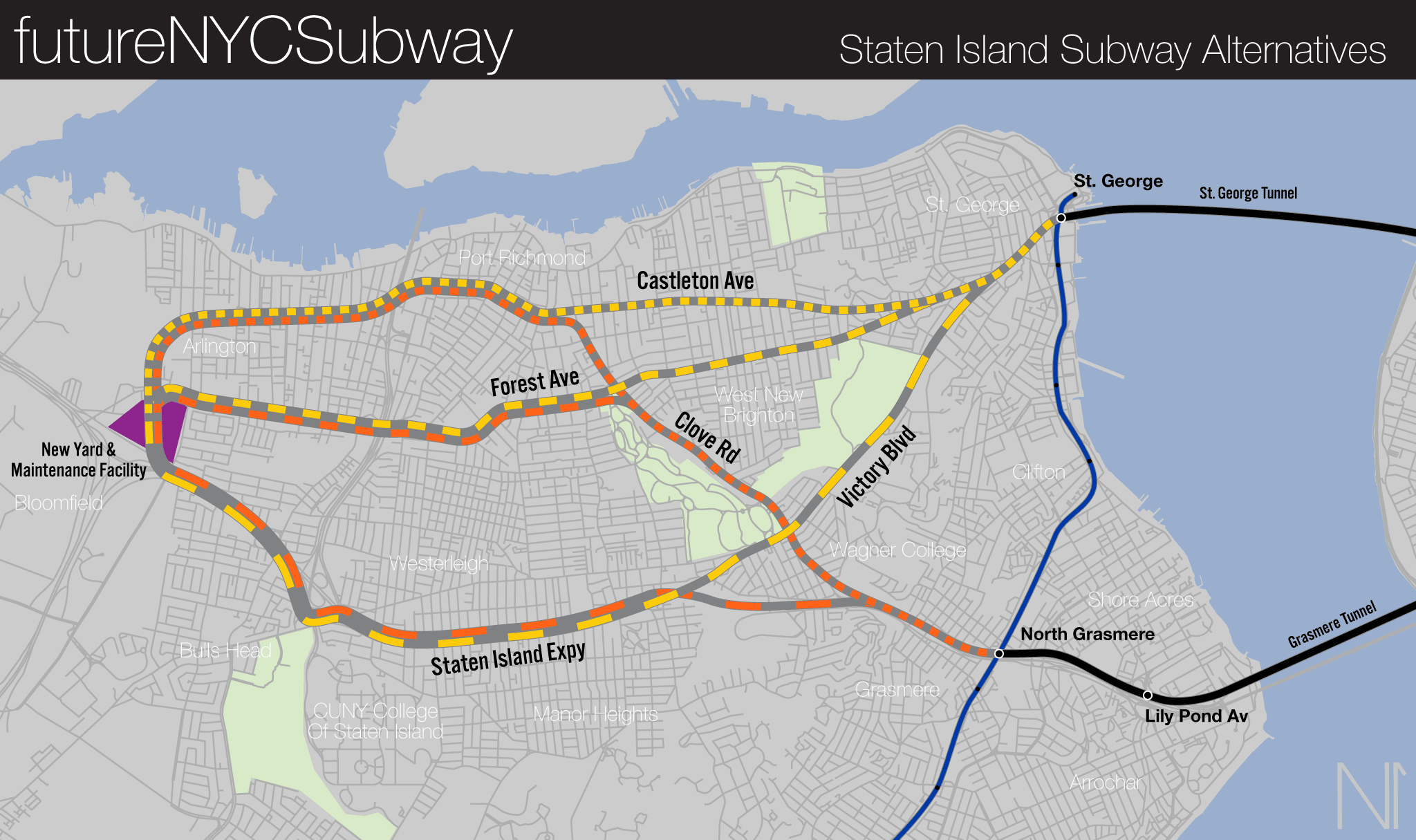
| Alternative | Length (miles) | Service Levels | Stations | Tunnel Cost | Above Ground Cost | Final Cost (Hard+Soft Cost) | Jobs Along Route | Jobs (NYC Total) | Cost Per Rider (Total) | Development Potential Multiplier | Final Metric |
| SIR Connection | 14 | 9 | 21 | $456,262,047 | $1,575,000,000 | $5,310,750,923 | 36,306 | 99,411 | $53,422 | .5 | 11.87 |
| St. George-Castleton Ave | 5.74 | 8 | 7 | $1,733,795,779 | $6,145,920 | $9,680,268,947 | 60,793 | 123,898 | $78,131 | .5 | 19.53 |
| St. George- Forest Ave | 5.2 | 8 | 7 | $2,509,441,259 | $0 | $10,742,178,340 | 57,939 | 121,044 | $88,746 | 1 | 11.09 |
| St. George- Victory Blvd | 6.9 | 8 | 7 | $1,368,786,141 | $11,404,800 | $9,183,812,902 | 58,675 | 121,780 | $75,413 | .25 | 37.71 |
| Grasmere-Castleton Ave | 5.94 | 18 | 7 | $1,825,048,188 | $6,145,920 | $10,487,845,859 | 54,157 | 119,809 | $87,538 | .25 | 19.45 |
| Grasmere- Forest Ave | 5.5 | 18 | 7 | $2,281,310,235 | $1,584,000 | $11,111,192,034 | 51,919 | 117,571 | $94,506 | .5 | 10.50 |
| Grasmere-SIE | 5.45 | 18 | 6 | 0 | $17,265,600 | $7,302,975,931 | 54,055 | 119,707 | $61,007 | .5 | 16.95 |
In considering where a new subway should run to, it’s important to consider that with any extension, additional train cars are needed. These cars require storage and maintenance. Given the constraints of existing facilities, it will be required that a new yard and facility be built on Staten Island for the extension.
Luckily, western Staten Island has large areas of undeveloped land. To more fairly compare them, I have designed each alternative to end at this location, a large patch of land bounded by Forest Ave, Goethals Rd North, and South Ave. I should note that I have not considered the costs of the new facility and new cars. These would be the same for all alternatives and do not affect the final cost.
The only alternative which does not consider this is the direct connection to the Staten Island Railway. For that alternative, the existing SIR facilities can be used and upgraded.
I am also considering the development potential along each corridor. This will be important for financing the project. The opening of the Verrazzano Bridge helped the population of the island double in a couple of decades. Building a rail tunnel will be essential for laying the foundation of turning the general land use of the island from suburban and car-dependent to more urban and walkable. The Development Multiplier is based on existing zoning and available sites. For instance, commercial zones, which are often single story strip malls, are easier to redevelop than a built out residential neighborhood full of single family homes.
The final metric is based not on the stand-alone alternative but rather on the subway plus tunnel to Brooklyn. All jobs along the new route are considered, not just on the island.
Direct Staten Island Railway
It is assumed that all historical proposals for a subway tunnel to Staten Island would have connected to the SIR at some point (in the same way the old steam railroads of Brooklyn were converted to elevated and subway lines.) The SIR could easily be “converted” to a subway, rather than the heavy rail line that it is currently designated, as there are no freight customers along the line anymore. But this would still be costly.
Every SIR station would need to be doubled in length to support subway trains. Elevators and fare gate areas would need to be built. Based on the few new infill stations which have recently been built, I am assuming average costs of $75 million a station. Not that I think every station will be that expensive, rather that some will be easier to expand than others; so this is the average.
While this may seem a “simple” solution, the major downside is that much of the island wouldn’t see an increase in transit access. At most, buses would still be required as feeders to the subway. This could have the benefit of spreading transit-oriented development over more of the island, putting less pressure on the north, but large chunks of the southeastern cost of the island are in flood zones.
Adding 14 miles to an existing subway line will cause operational issues as well. Whichever line is connected would automatically become the longest in the system. The shortest option (using the Grasmere-95th St alternative) would connect Tottenville to Astoria-Ditmars, a distance of 32.4 miles and 58 local stations.
Driver fatigue and delays would mount up over such long runs. Service levels on the island would need to be balanced with needs elsewhere in the city which could mean the MTA would spend extra money on service to Staten Island than the island needs.
This alternative scores a metric of 11.87. Cost-per-rider is the lowest, at $53,422, and overall cost is $5.3 billion.
St. Geroge-Castleton Ave
A subway line along Castleton Ave to St. George would have a number of benefits. It would directly connect at least three job centers located on the North Shore, including Richmond University Medical Center. Four of the most heavily used bus lines on Staten Island run along or close to Castleton Ave. It would be a more appropriate replacement for the SIR North Shore Branch and could, if routed properly, still utilize part of the abandoned ROW.
A potential subway extension here would run 5.74 miles. While this route runs through important job centers, the higher tunneling costs and lower development opportunities gives this a metric of 19.53. Cost-pre-rider is $78,131 and the overall cost is $9.6 billion.
St. George-Forest Ave
The Forest Ave corridor runs a bit south of the Castleton Ave one, and while it doesn’t serve the North Shore job centers as directly, it would still be within walking or bus transfer distance. A major benefit to this corridor is that it has more redevelopment potential. There are large shopping centers along Forest Ave that could see the types of development which would help pay for the extension.
Unlike the Castleton Ave route, a Forest Ave subway would be entirely underground. Higher construction costs would be off set by higher redevelopment opportunities. This gives the alternative a metric of 11.09, second best, with a cost-per-rider of $88,746 and an overall cost of $10.7 billion.
St. George-Victory Blvd and Staten Island Expressway
Victory Blvd runs from St. George to the Arthur Kill on the West Shore of the island. While it cuts a nice direct route across the island, it is over a mile and a half south of the major job centers on the North Shore. It’s worth considering, though, because it would directly serve the major colleges on the island, including Wagner College, St. John’s University, and the CUNY College of Staten Island.
A section of this route could also be built “cheaper” by using the Staten Island Expressway. While the expressway was not built with space for mass transit, a viaduct could be built above the road. The viaduct would make up more of the route, saving on cost.
The lack of direct job access and lower development opportunity give this alternative the worst metric at 37.71. Cost-pre-rider is $75,413 with an overall cost of $9.1 billion.
Grasmere-Castleton
If the Grasmere-95th St Tunnel option is used then these same corridors could be used, albeit crossing further south. A Grasmere-95th St Tunnel would include a 1.5 mile tunnel and viaduct with two new stations paralleling the Staten Island expressway and Verrazzano Bridge. A new station on the SIR would be built at North Grasmere to facilitate transfers.
A Grasmere-95th St Tunnel has the benefit of giving SIR riders a quicker option into Brooklyn and Manhattan. But it misses major job centers. Riders could still transfer to the SIR to reach St. George quicker than buses would be today. To connect Grasmere with the North Shore, a new tunnel along Clove Rd would need to be built to Port Richmond, and then on to Arlington.
This alternative has a metric of 19.45 due to lower development opportunities. Cost-per-rider is $87,538 with an overall cost of $10.48 billion.
Grasmere-Forest Ave
This alternative would be similar to the last, following Clove Rd, but turning along Forest. Similar to the St. George-Forest alternative, this route would be almost entirely underground (except along the SIE where it would be on a viaduct.) This shorter tunnel and cheaper viaduct section helps bring costs down. While it does not have as much development potential as the route to St. George, Forest Ave still has the highest potential of the different routes proposed
This means that the Grasmere-Forest Ave alternative scores the best overall metric of 10.50. The cost-per-rider is almost the highest, at $94,506 and the overall cost is $11.1 billion.
Grasmere-Staten Island Expressway
The final alternative would continue the viaduct along the SIE the entire way with no extra tunneling. This cuts way down on costs. But the trade-off is that this route bypasses most of the job centers on the north of the island. Much of the land around the SIR has been built up with single family homes. This gives the route the worst development potential of all alternatives.
The trade-offs leave this alternative in the middle of the pack with a metric of 16.95. Cost-per rider is $61,007, and the overall cost is $7.3 billion, the best for an alternative comprised of all new construction.
Conclusions
I don’t expect this post to settle any debates about what the best possible route to Staten Island will be. But I wanted to at least create a framework for a better discussion. When I set out to write this, I did so with my own preconceived notions about what the best route would be; I figured the cheaper costs of building along the SIE would win out. But per my planning credo, build transit where it’s effective, not where it’s cheap.
To that end, I must conclude that the best option here is an extension of the R train (with boosted service via the W) from 95th St to Grasmere in Staten Island, and then along Forest Ave. This route not only serves existing job centers the best, but it creates stronger cohesion on the island itself by creating an almost perfect cross. Free transfers to the SIR and subway will be key in creating this new backbone for the island.
I would suspect that a new subway would dramatically reduce ridership on the Staten Island Ferry, but given the popularity of the new ferry lines added around the other boroughs, I don’t think that a subway would outright kill the ferry off (especially if the subway doesn’t go to St. George.)
I have no doubt that there will be plenty of arguing over my costs estimates. Remember, they are just estimates based on a metric I made up. The idea isn’t to come to a final answer, but rather to get us thinking about how to get closer to the real cost.
People who don’t want to think about projects like this will always say it can’t be done because it will cost too much. But cost is relative, and they often have no idea what the real costs will be. More important to knowing the real costs is understanding that a cost and an investment are different. If a subway to Staten Island costs $7 billion, or $14 billion, is that expensive? Or is that an investment which will pay for itself?
In 2021 dollars, the Verrazzano Narrows Bridge cost $2.9 billion. At the time, Robert Moses said that adding a subway on his bridge would cost an extra $500 million. Adjusted for inflation, that would come out to $4.5 billion. While he most certainly was making that number up to have an excuse to block mass transit from being expanded, had he built a subway on the bridge (even at that cost) the project would still have been cheaper than building a tunnel today.
The purpose of this post isn’t to seriously propose a tunnel to Staten Island, but rather to demystify it. If we can put this project in terms of real numbers then it becomes real. Even if it costs “too much”, we at least can begin thinking about ways to turn it from a dream into a reality.
All data collected for this post can be found on a Flickr gallery I’ve uploaded.
Thank you for your detailed analysis. Maybe eliminating the reduced toll for SI residents would generate the funds if matched with Federal funding.
But looking at the low density of Staten Island neighborhoods a cheaper alternative to speed travel to St George would be building aerial trams.
Honestly, I like the B extension with the Grasmere-Forest Ave route best. The time reduction from 77 minutes down to 47 is a big savings and I think there might be a lot of riders who might switch from the SIM buses to the B train. The big issue would be Brooklyn riders on the West End Line who would be losing their current D express in favor of a R or W local train.
This was really great. Thank you.
I would think that if a tunnel between Brooklyn and SI were built, it would have to lead to an express subway service.
Would the following be possible under your framework:
D Train that starts at St. George. Transfers to Ferry, SIR, and buses there, but the subway goes no deeper on the island. No yard in St. George, but the D train will be serviced by the Concourse Yard.
This D train will follow the St. George tunnel, stop in the area of the Brooklyn Army Terminal to provide a connection to the IBX. It will continue to the northeast to join onto the express tracks of the 4th Ave line north of the 59th st station. Bay Ridge (R) and Sea Beach (W) trains will both be 4th Ave locals, utilizing the existing switches south of the 59th st station to merge together. The West End (B) train* will merge with the St. George (D) trains to form the 4th Ave express. This will amount to a very fast trip to Midtown and still provide a cross-platform transfer to R and W trains to the Financial District.
The idea would be to use half the capacity of the 4th Ave express tracks to link to Staten Island. Necessarily, this would mean that one of the Coney Island services (West End or Sea Beach) would need to run on the 4th Ave local, but overall it will provide a faster trip to a greater number of passengers. On the SI side, it would be closer to more job locations than Grasmere and provide more immediate transfer opportunities, even if it is not extended beyond St. George.
* All of the above assumes DeKalb deinterlining with RW to 4th Ave local, BD to 4th Ave express, and NQ to Brighton. If deinterlining isn’t done here, then RW to 4th Ave local to Bay Ridge or Sea Beach, D to Staten Island via 4th Ave express, N to West End via 4th Ave express, and BQ to Brighton.
I feel that just going to St. George will have somewhat limited usefulness, although it will definitely give SI bus riders an option for Brooklyn at the Ferry terminal, which is a good thing. The tunnel definitely needs to lead to an express service, which is why I posted earlier that I liked the option to extend the B to SI via Bay Ridge paired with a route along Clove Road and Forest Ave best. Unfortunately, that would result in either Sea Beach or West End riders losing their express service in favor of a 4th Ave local service.
If we deinterline 4th Ave in the way I’ve outlined then the West End doesn’t really lose anything. With higher frequency on both the local and express the worst case scenario is exactly the same trip times as today. It’s changing this perception that will be the big lift.
Agreed. And by having the West End train become the 4th Ave local, that would allow West End riders to have an express on their line, which some of them have been clamoring for.
Another terrific essay. I’m going to write to you with an idea expanding on several points you made, as I couldn’t contain it to a single comment.