
I recently went down a bit of a rabbit hole reading up about the Program for Action, the 1968-1972 plans by the MTA to greatly expand the subway network. There are a number of official maps floating around showing how the MTA evolved their plans. But after 1972 they quietly shelved many of these ideas as cost over-runs ran rampant and the city began to realize it had a fiscal collapse on its hands.
While the planned routes have been written about by myself and others, it dawned on me that there were no published service plans. This makes sense since this isn’t something that a transit agency usually gets to working out until a project is close to completion. There are general ideas, such as the Q and T trains having been proposed for the 2nd Ave Subway. But for something like the Super-express bypass, which would connect the BMT Broadway, IND 6th Ave and 2nd Ave subways through a new tunnel into Queens, the complexity of the operations would have not been worked out fully.
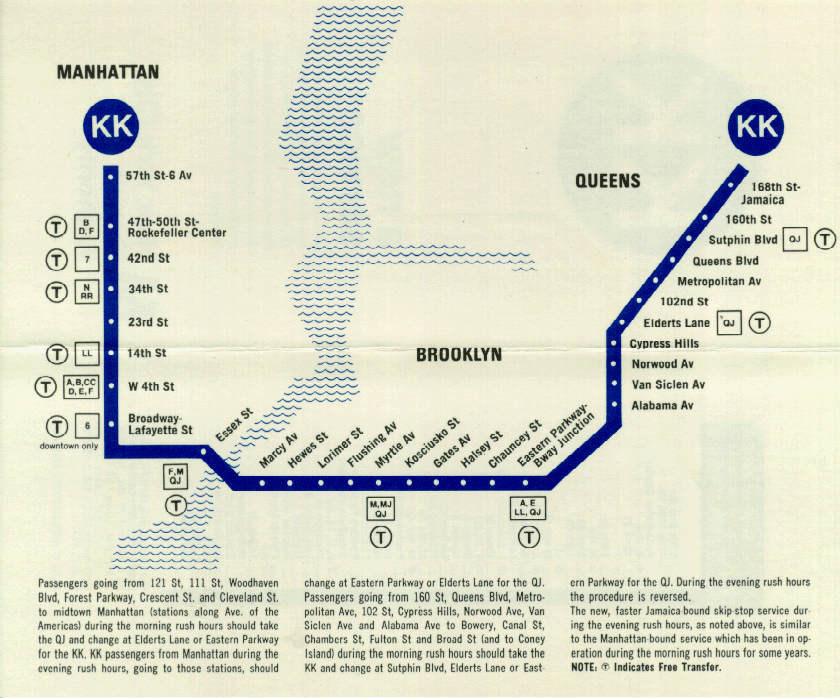
In fact, when the few miles of new tunnels which were actually completed (63rd St Tunnel and Archer Ave Lines), the MTA came up with a number of different service plans. Originally, the E and F trains were to continue using Jamaica-179th St as a terminal (which they had traditionally always done) and simply extend the N and G trains to Parsons/Archer. This was, of course, before NYCT swapped the N and R trains in Queens in 1987. When the Archer Ave Line opened in late 1988, service was simplified so that only the E train served the extension.
As a coda, this is the type of content that I hope to do more of now that I’ve ridded myself of the bird site. In the past I would have done a long thread and maybe cleaned it up for posting here. But maps and long for posts allow me to think more about my work and, hopefully, create better work.

2nd Ave Subway and Bronx Service
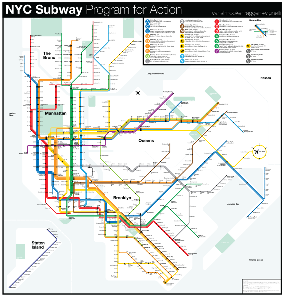
Because the 2nd Ave Subway is one of the few projects which actually broke ground, the service pattern is more defined. The current plan for the subway, finalized in 2007, extends the Q train north from 57th St/7th Ave to 125th St/Lexington Ave. When phases 3 and 4 open (south of 63rd St), the full-length 2nd Ave service will be known as the T train.
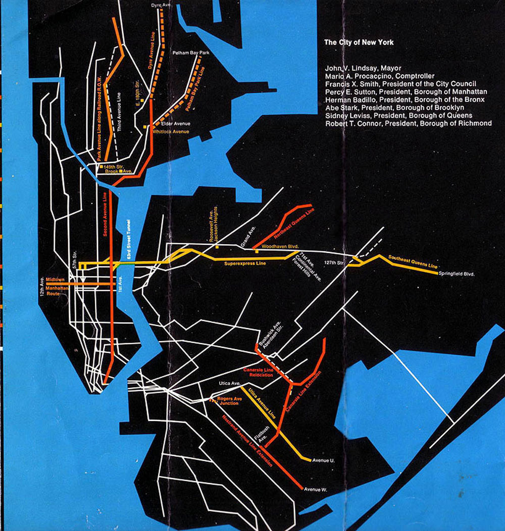
The original Program for Action concept had a branch of 2nd Ave south of 63rd St to Queens via the 63rd St Tunnel. This was removed from the 2007 version as there is no additional capacity on the Queens Blvd Line for such a service. The original alignment had the 63rd St Tunnel extending further east, along the Super-express Bypass to Forest Hills. Had this line been built, there would be ample capacity for such a branch. A connection between phase 3 of 2nd Ave and the 63rd St Tunnel will be built, just not used.
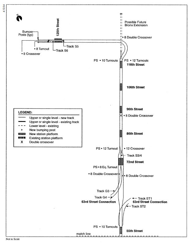
Here, the Queens branch of 2nd Ave runs super-express to Forest Hills, then along the local tracks of the Queens Blvd Line (the super-express bypass was planned to only connect to the local tracks east of 71st Ave), through Archer Ave and on to the Southeast Queens Line, terminating at Springfield Blvd.
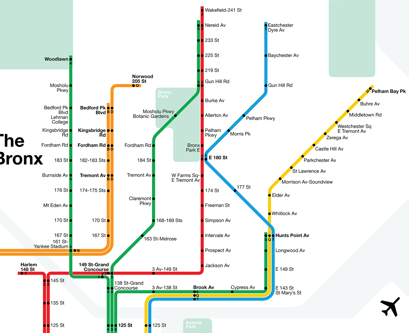
The current iteration of the 2nd Ave Subway will terminate at 125th St/Lexington Ave. This is a change from the more ambitious 1970s plan which called for 2nd Ave extending all the way into the northeast Bronx, branching to take over the IRT Dyre Ave and Pelham Lines.
An official study was published in 1977 which analyzed different alternatives for these Bronx branches. It looked at extending 2nd Ave along the Pelham Line, Penn Central (née Northeast Corridor), Dyre Ave, and White Plains Rd Lines. All things being equal, the study recommended using the White Plains Rd and Dyre Ave Lines. This would have, presumably, cut the 2 and 5 trains back to East 180th St.
For purposes of this map, I decided to stick with the original concept. This is due to the addition of the 3rd Ave El replacement service, which by 1977 had been long removed from plans. The 3rd Ave El was slated to be replaced by a new transit line along-side what is today the Metro North Harlem Line. While details are scant, I assume that this being the 1970s, commuter rail ridership would be lower and thus two of the Harlem Line tracks would have been converted to rapid transit and connected to the IRT Lexington Ave Line.
I used the original NYC RR Harlem Line stations as replacements, and unlike later plans which extended this line up to Wakefield, I opted to connect it back to the IRT White Plains Rd Line at Gun Hill Rd using the now abandoned lower level. This lower level was used to merge and terminate 3rd Ave El trains. My assumption is that this new line would have needed to access the 239th St Yard, so using the old connection made more sense.
With Lexington Ave service staying along the upper portion of the White Plains Rd Line, replacing the entire thing with 2nd Ave service seemed overkill. Therefore, the original service concept was kept. The IRT Pelham Line was built to accommodate larger trains, with platforms “temporarily” extended for the more narrow IRT cars. The Dyre Ave Line had originally been a commuter rail line serving wider cars, and the platforms here were also extended.
To make this all work, the tunnel portion of the Pelham Line was to be modified. The Brook Ave station was to have been enlarged so that the two side platforms would be converted into island platforms, with the 2nd Ave “express” tracks on the outside and 6 train “local” tracks in the center. 2nd Ave trains would continue north along the Northeast Corridor tracks to Hunts Point Ave where a second station would be built for 2nd Ave trains. 6 train service would terminate here. The 2nd Ave tracks would split, with two connecting to the elevated tracks of the Pelham Line and two running north to East 180th St and on to the Dyre Ave Line. The 2nd Ave connection to the Pelham Line would not have severed the connection to the Lexington Ave Line. This was to allow IRT trains to have access to the Westchester Ave Yard using the middle track.
Given that the stations along the lower Pelham Line have relatively lower ridership, I assume that late night 6 service would be cut back to a shuttle between Hunts Point Ave and 125th St, with 5 trains replacing the 6 as the Lexington Ave Local. The complex track layout at 125th St allows for such a service to be run without terminating 6 trains blocking through-running 5 trains.
Route 131: Queens Lines
The need for new transit to Queens had been evident for many years when the city decided to move forward with the 63rd St Tunnel. But planners didn’t know just where it would go or what kind of new service it would provide. As construction got underway, planners developed Route 131.
Route 131 had 4 parts: 131-A was the 63rd St Tunnel, 131-B was the super-express bypass, 131-C was the Northeast Queens branch along the Long Island Expressway, and Route 131-D was an extension along the LIRR Atlantic Branch to Laurelton, through the proposed Archer Ave Line (Route 133). The 63rd St Tunnel was originally conceived to alleviate crowding on the Queens Blvd Line, but this would go a step further and create new branches to serve transit deserts beyond the reach of existing line.
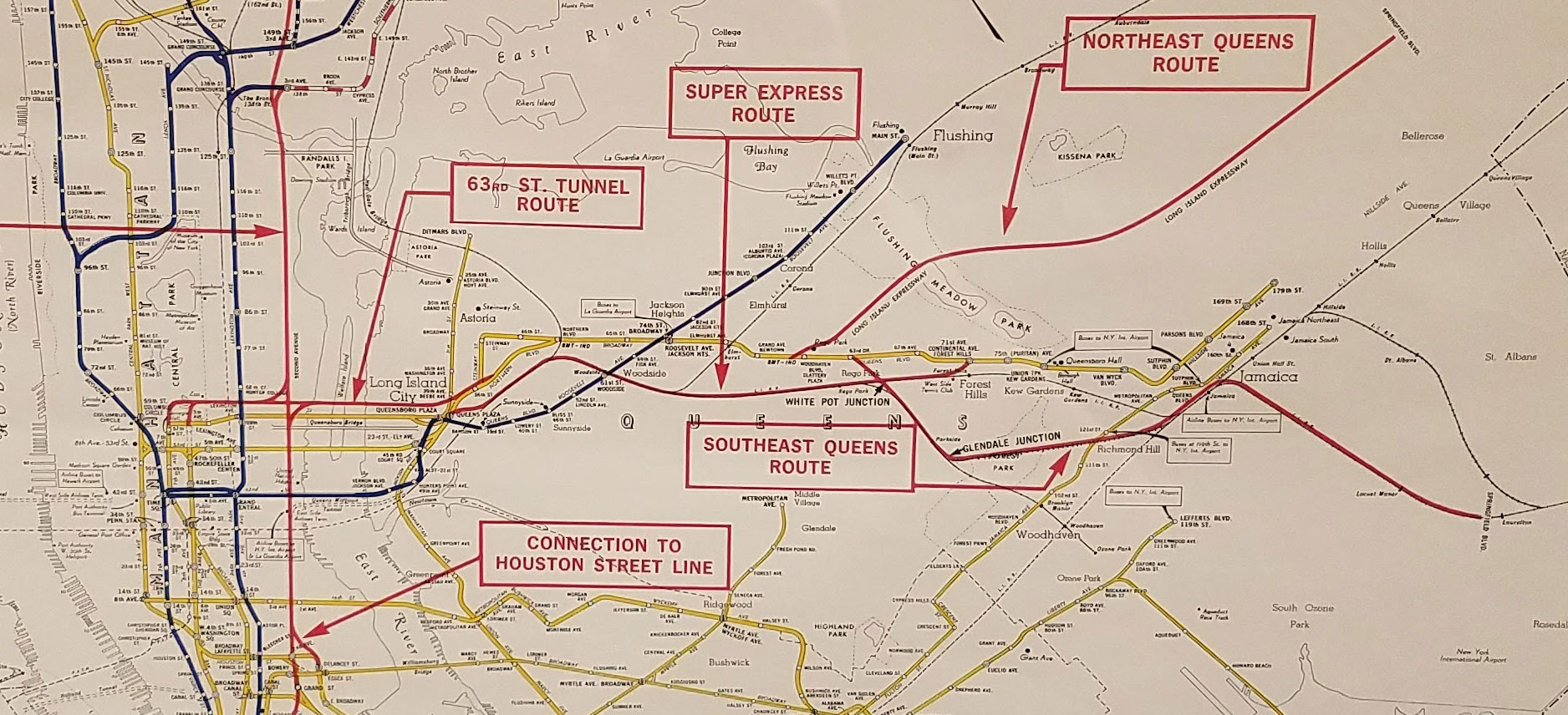
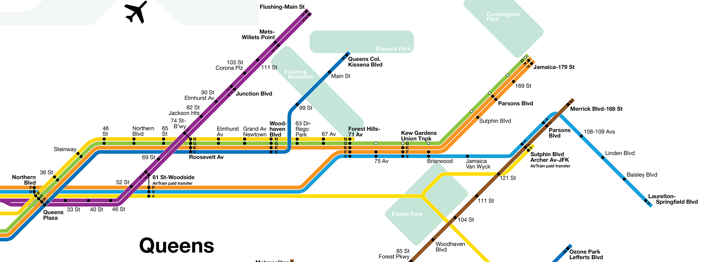
While the 63rd St Tunnel would eventually open in 1989, no other part of Route 131 would get past the drawing boards. The MTA opted to simply connect the tunnel to the Queens Blvd Line in Long Island City and today runs the F train through it. This leaves the tunnel running only at 50% capacity and unless the MTA chooses to swap service along Queens Blvd, the tunnel will go underutilized.
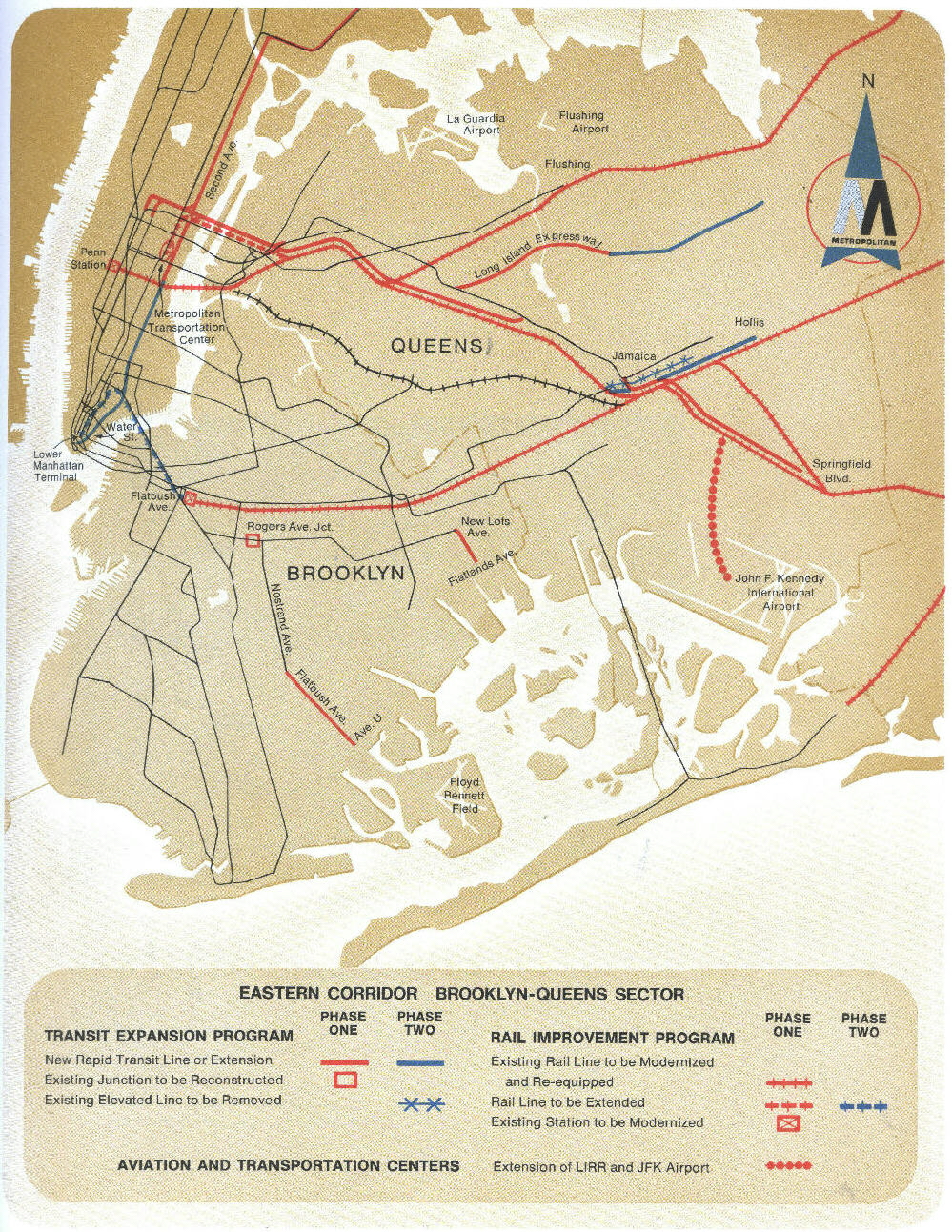
I did a deep dive into Route 131-D, or the Southeast Queens Line. I would love to do more on the other two branches, but I have yet to find any official documentation. With what’s known, I proposed a complex service arrangement along Queens Blvd.
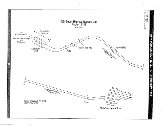
Plans for the connection between 63rd St and Queens Blvd evolved as construction went on. At one point there was to be a complex junction built, allowing the 63rd St Tunnel to access the Queens Blvd local tracks at Northern Blvd and allowing 53rd St Tunnel trains connecting to the super-express tracks heading east. This plan was simplified to keeping all track connections further east and adding a new station at Northern Blvd to allow for free transfers to Queens Plaza.
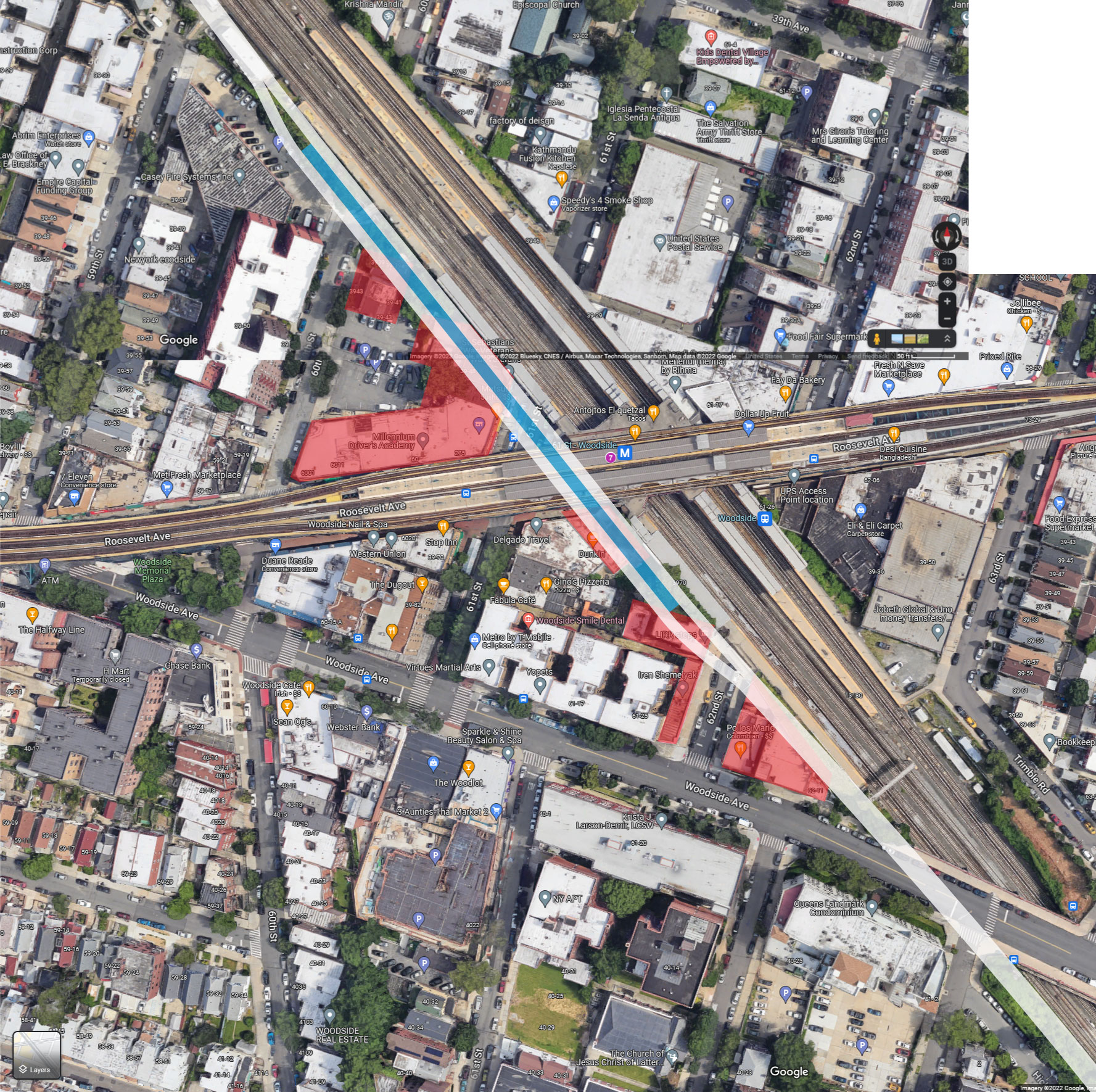
The super-express line was to run through Sunnyside Yards, with track leads to a new layup yard built somewhere in the yards themselves for subway trains. After Harold Interlocking, the tracks would ascend and run along the south side of the LIRR. The LIRR build a wide embankment through Woodside, but in a few locations buildings have been built right up against the right-of-way. This would require the demolition of a dozen or so buildings to expand the right-of-way enough for the two extra tracks and station at Roosevelt Ave.
After Winfield Junction (where the Port Washington Branch peels off) the LIRR Main Line reduces to 4-tracks but has space for 6. This is a remnant of the Rockaway Beach Branch, which connected to the outside tracks of the Main Line here before turning south in Rego Park. The super-express tracks would have required shifting the LIRR Main Line north by one track, but this would eliminate the need to take any homes along the way.
In Rego Park the tracks would descend back underground and turn down Yellowstone Blvd. The Forest Hills- 71st Ave station would have been expanded with a new lower, or even bi-level lower level for super-express trains. The tracks would continue east, rising up to connect with the local tracks of the Queens Blvd Line.
The idea was that by adding service to the local tracks east of Forest Hills, riders would use those trains instead of the normal express, freeing seats up for riders in western Queens. Using this logic, I’ve developed a complex service pattern that balances the needs of the entire route:
As they do today, F trains would use 63rd St and run along the super-express to Forest Hills, after which they run local to 179th St. In the 1970s, the new Chrystie St Connection had created a KK train running from Jamaica to 57th St. This was soon cut back to Broadway Junction. Here I assume that line is kept, but is routed through 53rd St and runs fully express along Queens Blvd to 179th St. The 2nd Ave V train would use 63rd St and super-express to serve the new Southeast Line.
The K would be a day time-only service. This extra level of service would not be needed at night, but eliminating it would cut off direct service along Queens Blvd from Long Island City to Jamaica. Therefore, the G (or possibly the N) would be extended to 179th St at night.
The last part of Route 131 is the Northeast Queens Line. This would most likely not have been built until after the super-express had been opened as it proposed branching the Queens Blvd express at Woodhaven Blvd, potentially knee-capping Jamaica service until the super-express could be opened.
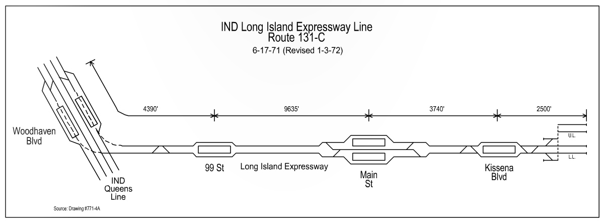
Route 131-C proposed finally expanding the Woodhaven Blvd station from a local into an express stop (provisions for such an expansion were built into the line in the 1930s), and creating a full flying junction below the station allowing for either express or local trains to branch off. The branch would have run under the southern LIE service road until the Grand Central Parkway, where it would run along a viaduct across Flushing Meadows Park. On the opposite side, the line could have run under the LIE service road or at-grade along a central median down the LIE.
A branch like this, especially a Queens Blvd express train, would have done wonders for reducing crowding on the 7 train and at Roosevelt Ave-Jackson Heights station.
Southeast Brooklyn Extensions
The Program for Action threw in two well known unbuilt lines for Brooklyn, the IRT extension of the Nostrand Ave Line and Utica Ave Line. These have been covered before, so I won’t spill much digital ink.
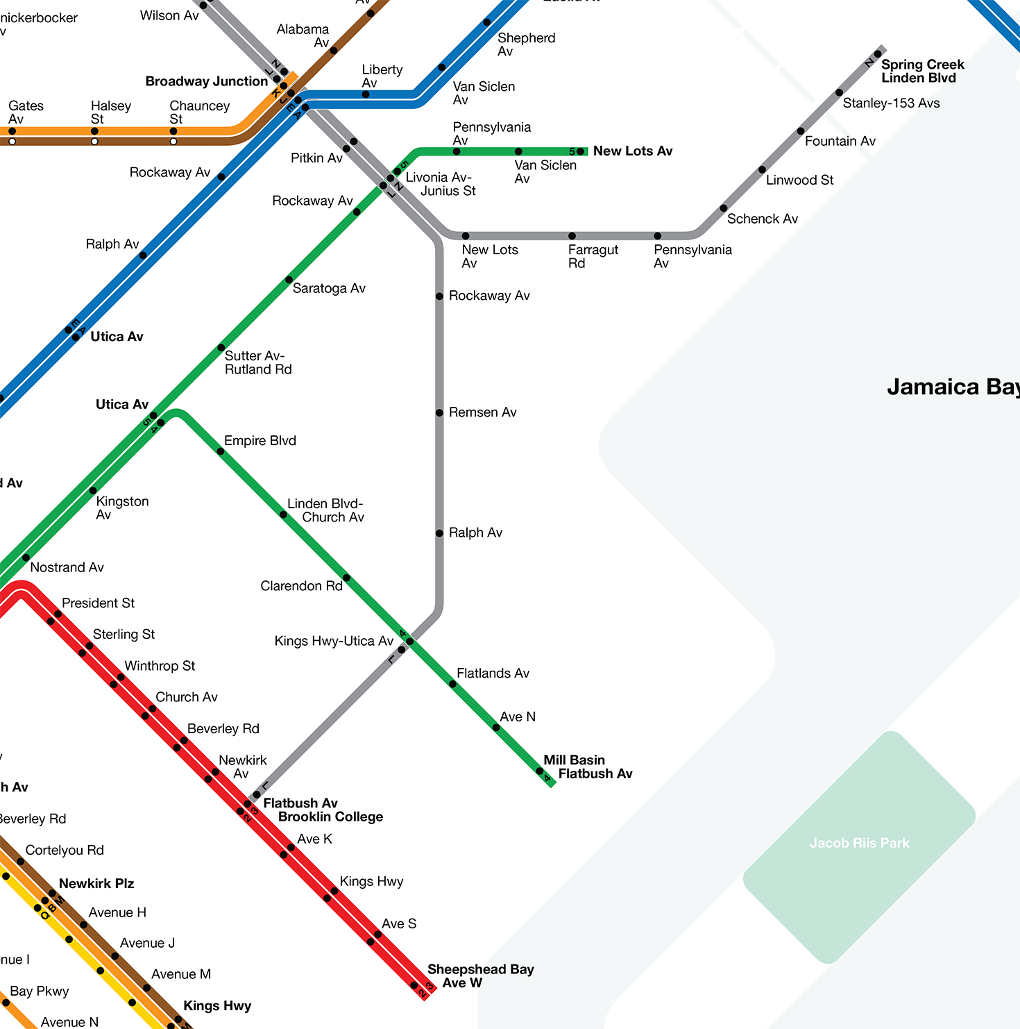
The most interesting proposal is the relocation and extension of the L train. South of Bushwick Ave, the L train runs above ground on an elevated structure. This was to allow the “new” subway to 14th St to connect with the older elevated network and serve Canarsie and East New York. As much of that network was replaced by subways, L train service was simplified. But the complex web of elevated tracks remained and was seen as a blight on the neighborhood.
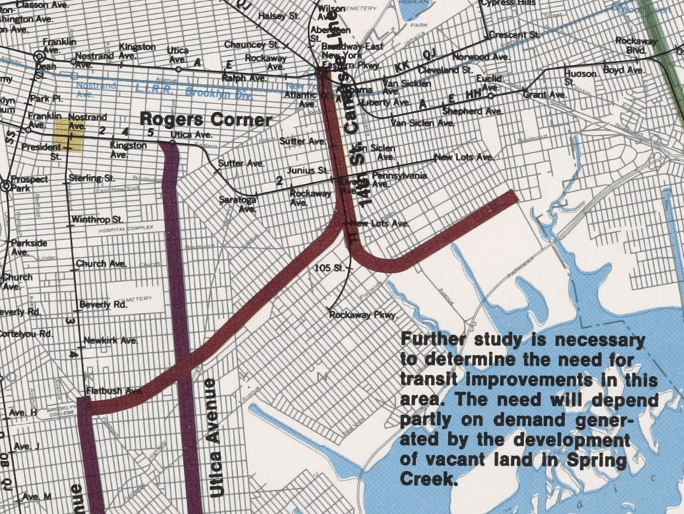
Plans called for rerouting the L train through the East New York Tunnel, a lightly used 4-track freight (and former passenger) rail tunnel under Broadway Junction. The new stations would have been in the open cut, directly below the elevated L train tracks. Presumably to justify the cost, planners devised two branches to extend deeper into southeastern Brooklyn.
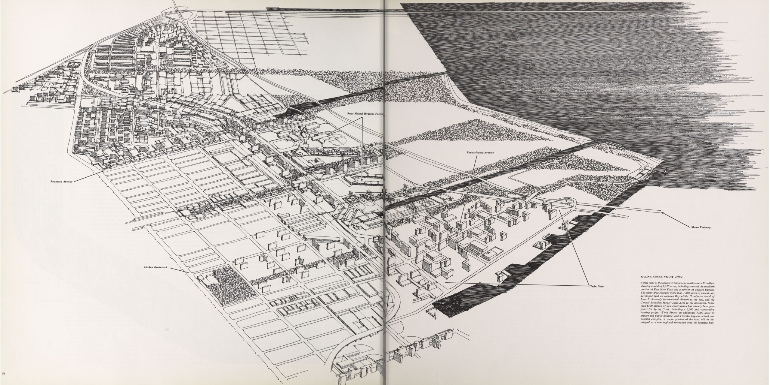
The first Program for Action plan in 1968 called for a simple one or two station extension of the IRT New Lots Line to Flatlands Ave. But as planning for a Cross Brooklyn Expressway through the area progressed, planners saw an opportunity to build rapid transit along the median of the new highway. Plans were changed to have a branch of the L train run along this route to Spring Creek.
A second branch would have been run along the LIRR Bay Ridge Branch to Flatbush Ave, Brooklyn College. This is the genesis of the Triboro RX and now Interborough Express Lines. I have personally been a bigger proponent of this alternative, rather than a single circumferential line to Queens, as it would more easily bypass the Fresh Pond freight yard and provide better connections to existing lines.
A few other ideas
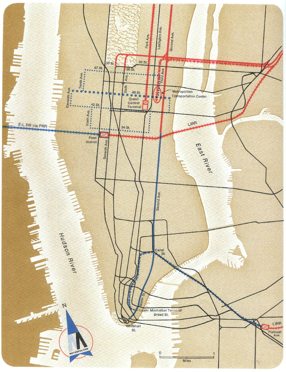
The Program for Action wasn’t just about expanding the subway. It dealt with regional commuter rail as well. One of the major projects for the LIRR was to expand it through the 63rd St Tunnel on the lower level to a new east side terminal. Unlike Grand Central Madison today, the Metropolitan Transportation Center was to be under 3rd Ave and have a special terminal for airline passengers. Passengers could check in here and then be whisked to JFK Airport.
To show this I used the visual language of the AirTrain. Unlike the AirTrain, this service would be run by the LIRR and run along their tracks. To do this planners repurposed the Rockaway Beach Branch and Lower Montauk Lines. AirTrains would run from Metro Transit Center along the Main Line to Rego Park and then along the Rockaway Beach Branch to Howard Beach. Unlike today, a transfer station would be built further north near Aqueduct for riders connecting to downtown Brooklyn.
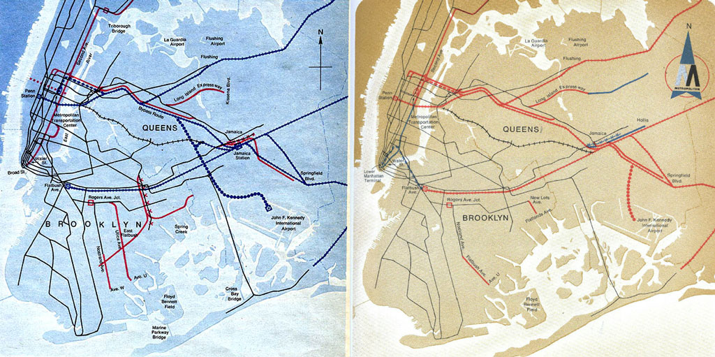
A second branch was planned to serve Long Island passengers. Unlike today, where the AirTrain runs along a viaduct above the Van Wyck Expy, the LIRR AirTrain was to leave Jamaica and run west along the Lower Montauk Line. In Forest Park, the line would enter a tunnel and curve south to connect with the Rockaway Beach Branch. Both branches were to serve JFK terminals.
The tunnel through Forest Park causes quite an uproar in the community as it would have required cutting down primeval trees. While some have pointed to this NIMBY backlash as the reason for the project being canceled, the fiscal collapse of the city had much more to do with it.
Within Midtown Manhattan, the Program called for a series of circulators that would move riders crosstown. These people movers were all the rage in the 1970s and a few have been built around the country to mixed results. While such a people mover is shown along 48th St, it’s hard to tell exactly what it would look like. Subways were expensive so it may have been a much simpler piece of infrastructure (possibly moving sidewalks). Because of this ambiguity, I’ve left it off the map.
What I did include was the so-called “cup handle” through Alphabet City. Lower East Side residents were perturbed that the 2nd Ave Subway was still going to be a long way from their neighborhood. To secure political support for the entire program, MTA planners devised a proposal to have the 2nd Ave Subway bulge eastward below 14th St. As this idea was further developed, a more simplified concept was drawn up with built a shuttle subway from 2nd Ave/East Houston St, up Avenue C, and then down 14th St to 1st Ave. The subway would have used the unused middle tracks at 2nd Ave (originally designed for the South 4th St Subway to Williamsburg).
While I don’t for a second think that this would have actually been built, I know readers would have brought it up had I not included it.
Eagle-eyed readers might notice I’ve made a few regular service changes as well. This is to tie things back to the 1970s. E trains once ran to Rockaway Park (during the day) so I’ve added that back and sent the C trains back to WTC (though, through sheer laziness I did not return C trains to the Grand Concourse). I’ve extended M trains back along the Brighton Line, giving those riders a one-seat-ride to Lower Manhattan.