
The MTA dropped their long awaited planning study for the Interborough Express (IBX) and have selected Light Rail Transit (LRT) as the preferred mode of transportation. This was hinted at months ago when a number of Twitter posts alluded to issues running Conventional Rail (CR) like subway or LIRR trains through the East New York Tunnel.
For those who’ve been living under a rock for the last year, the IBX is a circumferential rail line running between Bay Ridge, Brooklyn and Jackson Heights, Queens. The project is an evolution of a Regional Plan Association idea from the mid 1990s called the Triboro RX. The Triboro Rx was first proposed as the backbone of an outerboro regional rail network. This eventually was whittled down into a single line running from Bay Ridge to Co-Op City in the Bronx.
In 2022, in her very first State of the State address, New York Governor Kathy Hochul proposed the IBX seemingly out of the blue. The MTA had been tasked with doing a feasibility study on the line in 2019, and while the study was delayed by the pandemic, it appeared that the plan to run trains over the Hell Gate bridge was cut early on. No longer serving three boroughs, the project needed a new name, so the IBX was created.
Both the Triboro and IBX share the same concept: between Brooklyn and Queens runs a lightly-used freight line that takes freight cars from NJ (which are floated across the harbor on barges) and runs them up to New England. The route was originally made up of two rail lines: the LIRR Bay Ridge Branch (which itself had a branch to Manhattan Beach) and the NY Connecting Rail Road, which included the Hell Gate Bridge. The LIRR owns the section from Bay Ridge to Ridgewood, CSX owns it from there until the Hell Gate Bridge, which is owned by Amtrak.

While some sections of these tracks had passenger service, namely to Manhattan Beach, service south of the Hell Gate Bridge connection (which serves the Northeast Corridor into Penn Station) was eliminated in the 1920s and left to freight. It was in the 1920s when subway service to the outerboros first opened and took ridership away from the LIRR.
The right of way is primarily 2-tracks wide, but there are a few sections which are 4-tracks. The original RPA plan called for simply upgrading the two tracks and sharing service with freight trains. But over the last 30 years, freight service has increased. Additionally, the Port Authority plans on running more cross-harbor freight barges, meaning that sharing tracks will be more difficult, especially if service is planned every 5 minutes.
Adding to the issue of freight is the political compromise that happened to get the IBX off the ground. Congressman Jerry Nadler has been a proponent of a Cross Harbor Freight Tunnel for many years. The proposed tunnel would run from Greenville in Jersey City, NJ to Bay Ridge. The route seems strange from the outset, since a similar tunnel to Staten Island (which would be shorter) hasn’t been seriously considered since the 1920s. The reason for Greenville over Staten Island is because of the Upper Bay Bridge, a freight rail bridge owned by CSX which plugs into the Oak Point Yard and Port Newark/Elizabeth, and from there the national freight network.
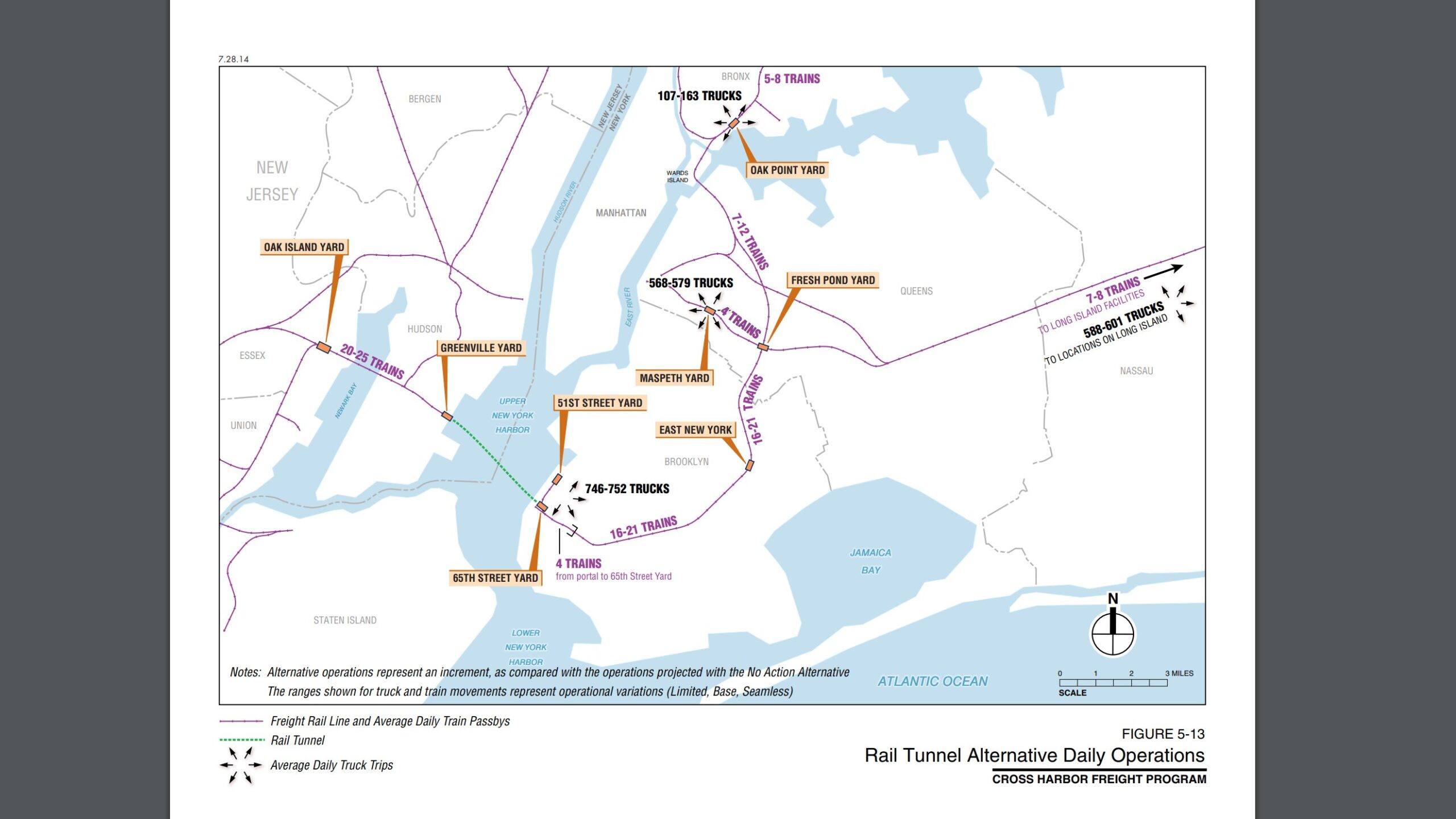
The IBX is being built with an agreement to move the Cross Harbor Tunnel forward. While such a tunnel will take much more time and money to build, the IBX is being built to allow for the future increase in freight. This creates a number of choke points where the freight and passenger service cannot mix; the East New York Tunnel (which is 4-tracks wide but needs to be modified for service) the All Faiths Cemetery Tunnel (2-tracks wide) and the Hell Gate Bridge (which is owned by Amtrak and will soon seen increased passenger rail service in the form of Metro North’s Penn Station Access).
These choke points, even without added freight, were always my concern about this project. The IBX has great potential to change the way people travel around the city, but if corners are cut, service won’t be consistent enough to entice people to take it. What I see in the MTA’s report are political choices being made because the project is being mandated from on high. So let’s break things down.
Why LRT Was Chosen
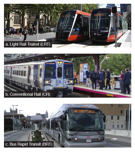
The first thing to understand about IBX is how Light Rail and Conventional Rail differ. Light rail in this context are in essence modern streetcars, but specifically ones which run on their own right-of-way, not sharing the street with automobiles. LRT became popular in the 1990s and early 2000s for new lines in smaller cities that had ripped up their streetcar networks long ago. Running along a dedicated ROW allows LRT vehicles to run faster and not get bogged down by traffic.
Conventional Rail is exactly what it sounds like, something akin to LIRR or Metro-North trains. Most of the IBX ROW is owned by the LIRR, so CR service would use similar trains that one rides along the LIRR (though these would be most likely equipped with additional doors and more standing room.) CR has a higher operating cost as the trains are larger, but they can hold more riders and use the existing LIRR network to access maintenance yards.
Lastly, Bus Rapid Transit (BRT) was also looked at. BRT would also require a dedicated ROW, but due to the lack of a fixed guideway, the ROW for buses would need to be wider. BRT is also less ideal because of capacity constraints: trains can be coupled together, buses can’t.
When the IBX was first announced, most observers figured that CR would be chosen. But when planners looked closer at the ROW, they discovered that there were a number of technical issues that made CR more expensive and complex, and the flexibility of LRT better suited
Longtime readers of my blog may have noticed that I didn’t talk much about the Triboro Line in my futureNYCSubway posts. It wasn’t that I never saw the value in the line, but rather I always questioned the overly simplistic plans from the RPA. They often claimed that the entire route, from Bay Ridge to Co-Op City could be built for $2 billion. This was never going to be the case since some of the ROW lacked a second track and nothing was electrified. Mixing freight and passenger service also requires specific physical separation, which adds to the cost. With the MTA doing a corridor analysis, we can now see the good and bad of the overall plan.
The Good
Light Rail is OK
The problem with many railfans is that they are often so focused on the trains themselves and not what the trains can do. Circumferential transit lines, because they often bypass major destinations, usually have lower ridership than radial lines. All one has to do is look at the G train, the only circumferential train in NYC, to understand (though the MTA could stand to run a few more trains at rush hour.) The IBX was never supposed to have ridership that rivaled the 7 train, so lower capacity is ok.
LRT was always perfectly suited for this task. CR had an advantage due to the existing network, where LRT has to start from scratch. But with an underused rail yard in Sunset Park, the supporting infrastructure is relatively easy to install here.
LRT is more flexible than people think. While a single LRT vehicle holds fewer riders than a CR car, LRVs can be combined into longer trains. This means that, during the day, IBX trains could be 3 or 4 cars long, and at night 1 or 2 depending on demand. While CR trains could also be run this way, their operating costs would be higher.
There is nothing wrong with LRT if done correctly. Light rail is a good idea, but the devil is in the details and looking at the recent report from the MTA, corners are being cut which will make the IBX far less useful than it could be, and will end up costing the MTA more money in the long run. If built right, there is no reason that LRT couldn’t be upgraded to CR at some point in the future. The vehicle isn’t the issue here, it’s the service.
The Bad
East New York Tunnel

The first problem that planners saw was the East NY Tunnel. The tunnel was opened in 1914 as part of a legally mandated grade-elimination project by the LIRR. The tunnel has four tubes, two for freight and two for passenger service; there is an abandoned platform located at the southern portal of the tunnel that allowed passengers to transfer to the still active LIRR East NY station above.
Historical records indicate that this tunnel was electrified, but unlike the rest of the LIRR, power seems to have come from overhead catenary rather than a third rail. If the tunnel had a third rail, it would have needed to be wider to allow for a bench wall, an elevated pathway along the side of the tunnel that allowed passengers to walk through, in case of emergency, without being exposed to the third rail. If trains were using catenary power, they wouldn’t be exposed to the power lines on the ceiling of the tunnel.
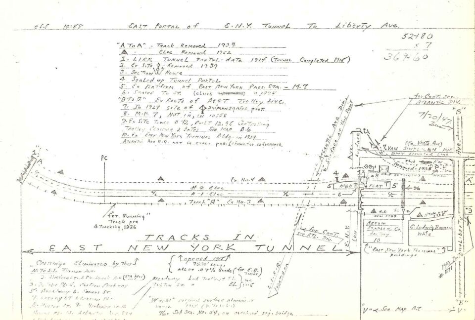
I’ve seen a number of folks comment, asking if the MTA could just expand the tunnel. That’s not something that is possible with a cut-and-cover tunnel like this; There is no place to expand into. The only way such an idea would be possible is if one of the freight tubes was eliminated and the other tunnels “expanded” into that space, but even this is probably not possible without rebuilding the entire structure.
The only area of the MTA that uses catenary power are Metro-North trains which operate into Connecticut. LIRR trains use 3rd-rail power or diesel engines. Modern LRT almost always uses catenary power, so from the point of safety, LRT would work fine for the East NY Tunnel. While it would be possible to use CR trains that use catenary power, it is the next bottleneck which makes this a moot point.
The former platform still sits under East NY Ave, and a few people have asked me if the IBX will use it. From what I have seen, I doubt it. The station has a high-level platform, the same you see at all modern LIRR stations. With the IBX being LRT, most stations are going to have low-level platforms (which saves on cost). Additionally, from the renderings, it looks as if the freight tracks will be on the “outside” of the route while the passenger tracks are on the “inside”. The abandoned station is on the outside, the future freight tracks, so a new station would be needed anyway.
Bad or Missed Transfers
The point of a circumferential transit line is to create a bypass around a congested area and allow riders to save time getting from Point A to Point C without first needing to go to Point B. To do this effectively, transfers need to be as easy and seamless as possible. This is where the cut corners of the IBX plan really stand out.
Because the LIRR and subway companies were all private, transfers between systems were an afterthought. A perfect example of this is at Broadway Junction. Here, there are four active rail lines, along with the proposed IBX. But due to the failures of planning, the transfers here are the worst in the system.
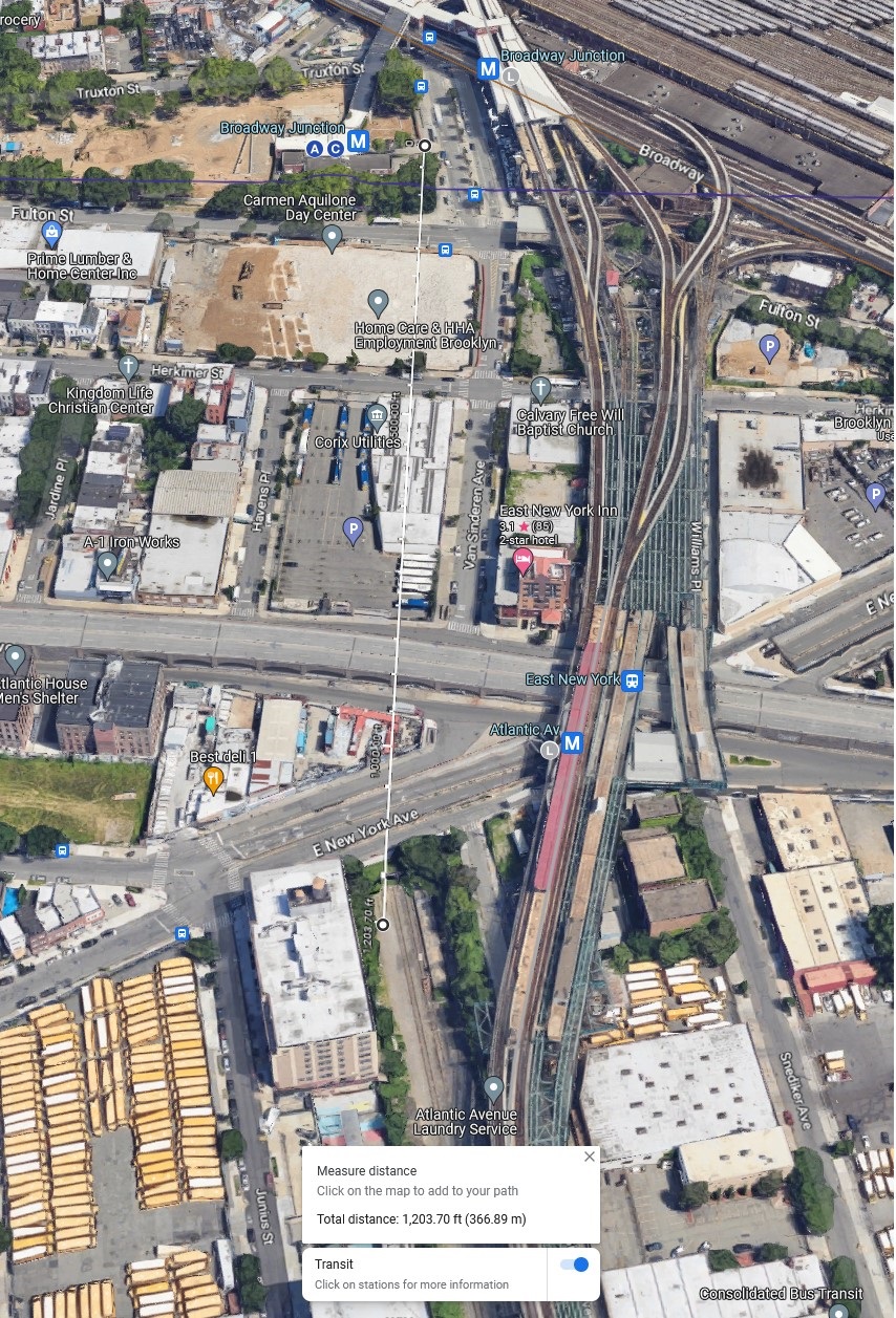
The BMT Jamaica and Canarsie Lines have a relatively easy transfer. As the lines were built by the same company, the two stations cross over one another. The IND Fulton St Line was built later, replacing an elevated BMT line along Fulton St, which is why the transfer between the subway and elevated lines requires such a long escalator ride. The LIRR station at East NY (both active and abandoned) is about 1,200 feet south of the complex, and the only access to the subway is at the following L train station, Atlantic Ave.
According to the map, planners are not proposing a station closer to the Broadway Junction complex, but instead intend to require riders to walk the 1,200 feet from Atlantic Ave to Broadway. This is due to the fact that there is no station within the East NY Tunnel in the area of Fulton St or Broadway. What makes this idea even worse is that there is no easy way to traverse Atlantic Ave and East New York Ave as a pedestrian. The transfer is in name only.
Building a new tunnel and station under Broadway Junction is certainly not a cheap proposal. But without it, the usefulness of the entire IBX comes into question. A cut-and-cover tunnel could be built along Van Sinderen Ave as a bypass to the East NY Tunnel. MTA planners apparently want to propose a TBM tunnel which would be over a mile long, with a deep station. This shows the sorry state of planning at the MTA and in NYC.
[UPDATE 10/28/2024]
At a press conference today, it was announced that the MTA is looking at moving the East NY-Broadway Junction station to the north side of Atlantic Ave, roughly under the MTA-owned bus parking lot at Havens Pl and Herkimer St. This will split the difference between the NYCT Brodawy Junction station complex and the LIRR East NY station. Given that there is no space in the exiting East NY tunnels for a station, it will be interesting to see what work will need to be done to build a station here, along with some kind of connecting mezzanine to either existing stations. The RFP put out by the MTA will likely include a request for these designs.
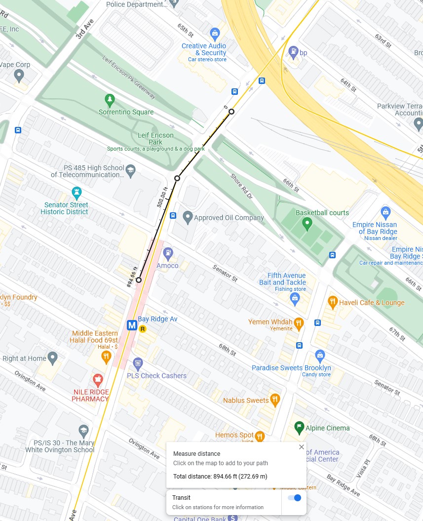
The other missed transfer, though somewhat less important, is in Bay Ridge. The map shows a transfer to the R train at 4th Ave. However, there is no station along the ROW at 4th Ave. The closest R station is at Bay Ridge Ave, almost 900 feet south of the ROW (the 59th St station is 1,300 feet north). What makes this less impactful than Broadway Junction or Roosevelt Ave is that there will also be an IBX station at 8th Ave, next to the N train station. This will see a much higher transfer rate than at 4th Ave due to the convenience.
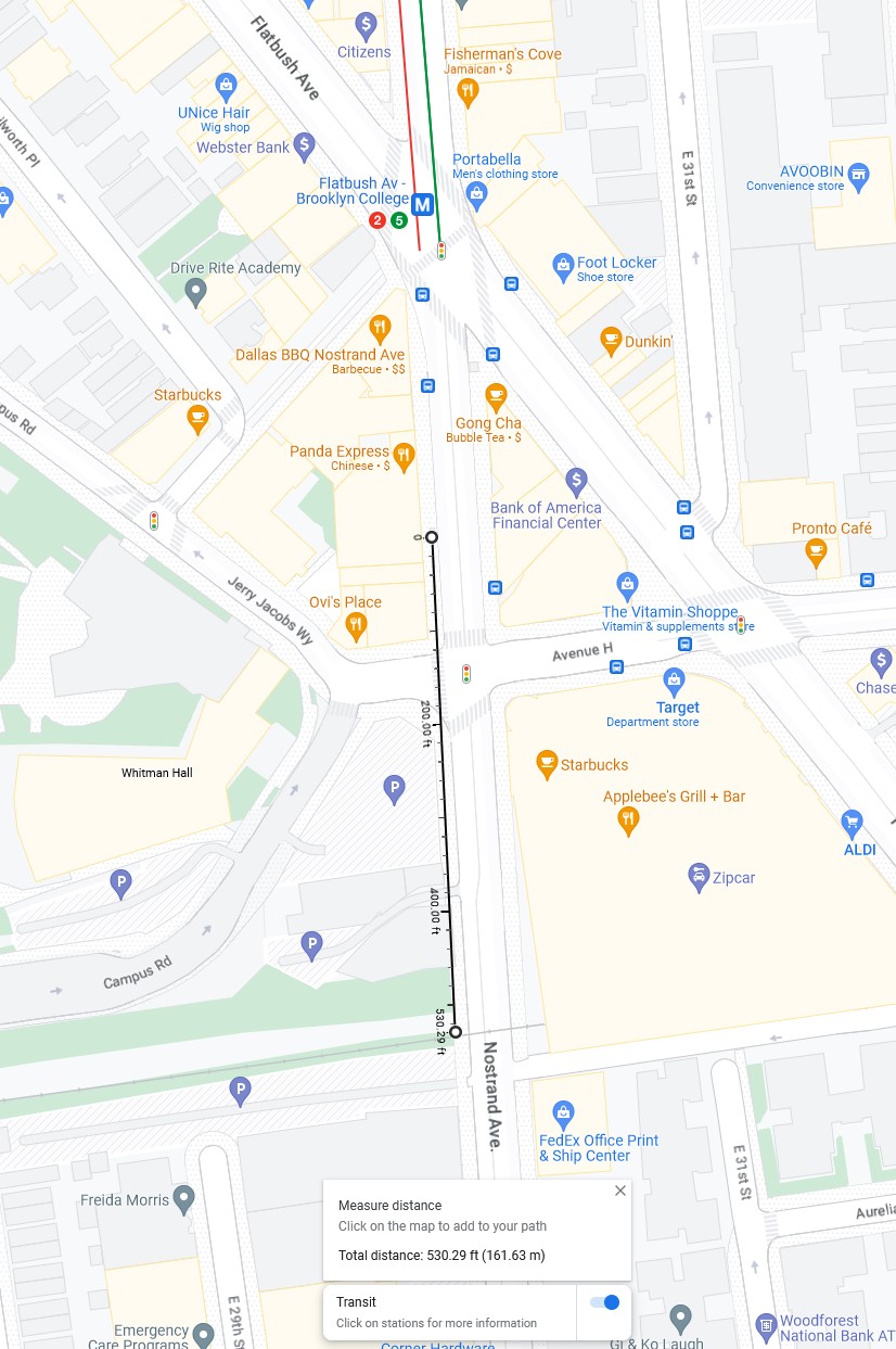
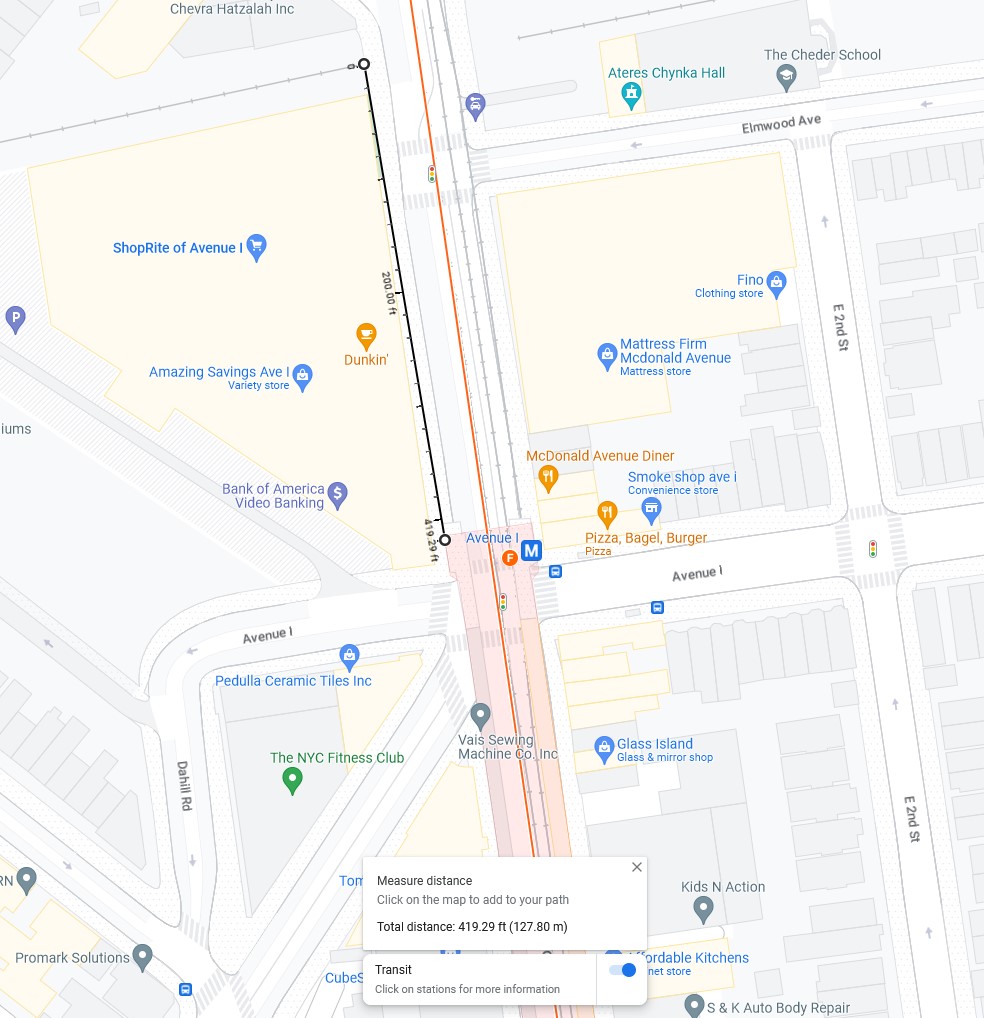
Other transfers will require riders to walk down a few city blocks to change trains. A major hub, the Brooklyn College-Flatbush Ave station will see especially high ridership. But the ROW is 500 feet south of the closest subway entrance. Likewise, at McDonald Ave, the ROW sits in between two F train stations; 18th Ave (an express station) is 525 feet to the north and Ave I (a local station) sits 400 feet to the south.
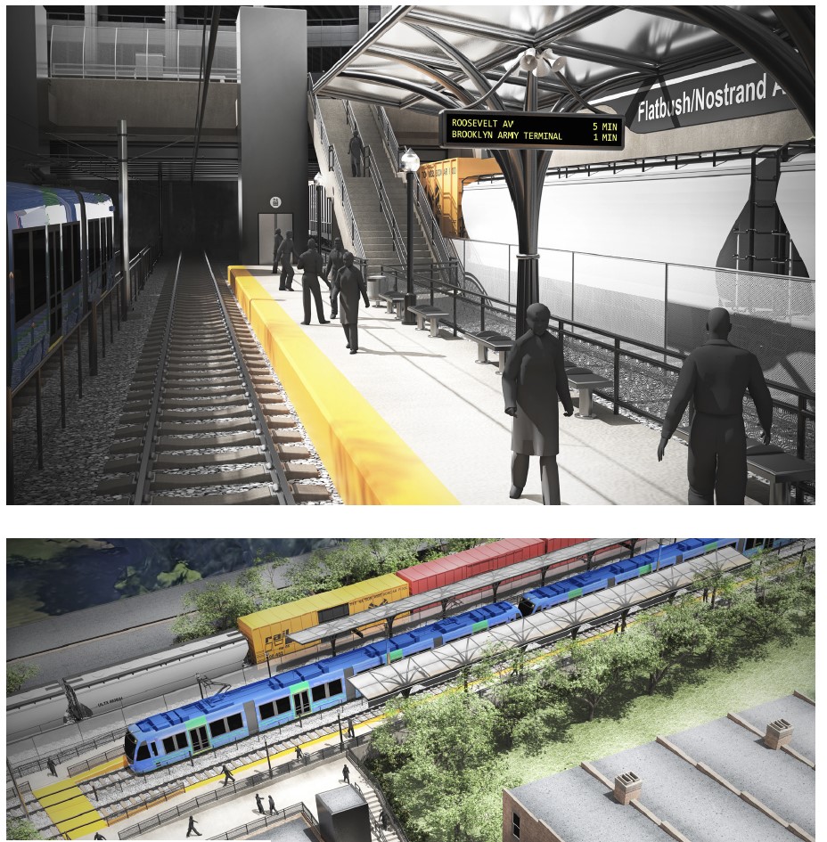
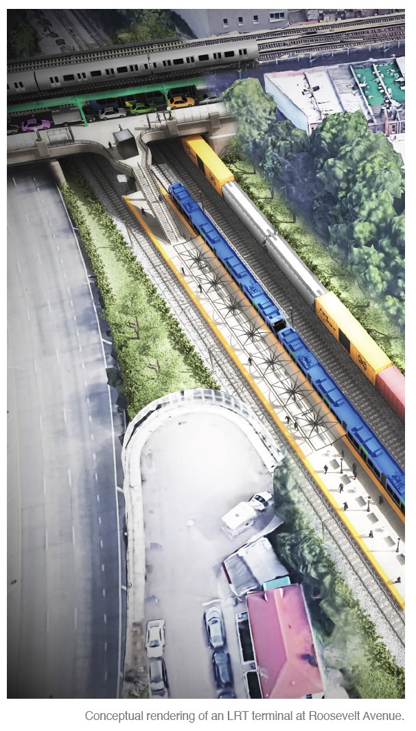
Roosevelt Ave
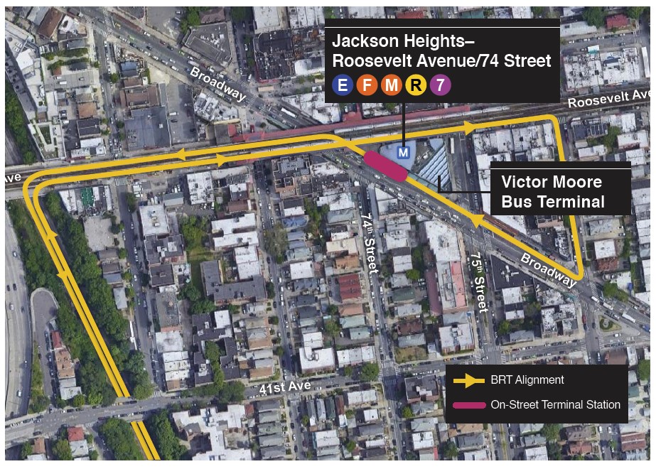
In the feasibility study that the MTA quickly slapped together a year ago, it was mentioned that both LRT and Bus Rapid Transit (BRT) were being considered as they added the flexibility of allowing vehicles to run on city streets. This would have been beneficial for the proposed terminal at Roosevelt Ave. The NY Connecting RR ROW is 600 feet west of the entrance to the Roosevelt Ave-Jackson Heights subway station complex, a major transfer point for subways and buses (including the Q70 to LaGuardia Airport).
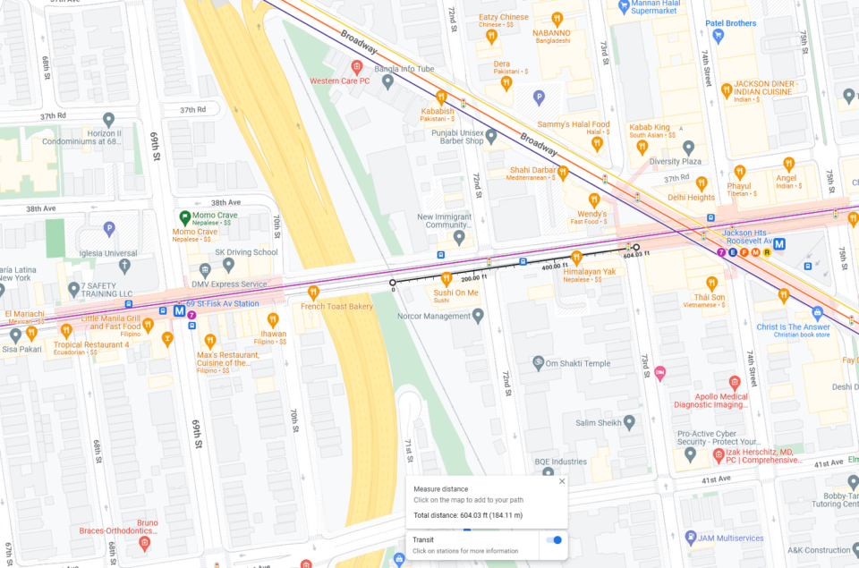
Having a seamless transfer to the subway is key for the IBX to work, and the original concept had LRT and BRT running along the streets to serve the bus terminal at Roosevelt Ave and 75th St. Now, the LRT concept has been cut back to a simple station at Roosevelt Ave on the ROW. This means that riders, especially those with luggage coming from the Q70, will have to walk two blocks to get to their trains. This is not ideal.
Stations, or Lack Thereof
The MTA asked the public to provide input for where stations would be located. Not surprisingly, stations are proposed where they cross radial lines heading into Manhattan. But more unfortunate is where the IBX runs through transit deserts.
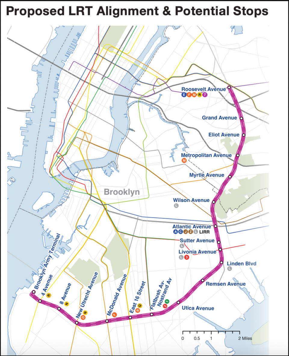
East Flatbush and Canarsie stand to benefit the most from the IBX, as building a subway under Utica Ave is probably a long way from happening any time soon. But the MTA is only proposing two stops through this area of Brooklyn, at Utica Ave and Remsen Ave. Meanwhile, in Brownsville, the IBX will have stops mirroring each of the existing L train stations. Additional stations should be proposed at Rockaway Parkway (only a couple blocks south of the Brookdale Hospital complex), and Ralph Ave (close to the Brooklyn Terminal Market, NYCHA Glenwood Houses, and a large public school complex on Flatlands Ave).
It’s worth noting that the IBX will also spur development along the way and this section through East Flatbush has a number of large blocks which could be rezoned and redeveloped with affordable housing. While stations can always be added later, it seems like a missed opportunity to not consider them before shoves break ground.
The Ugly
Metropolitan Ave
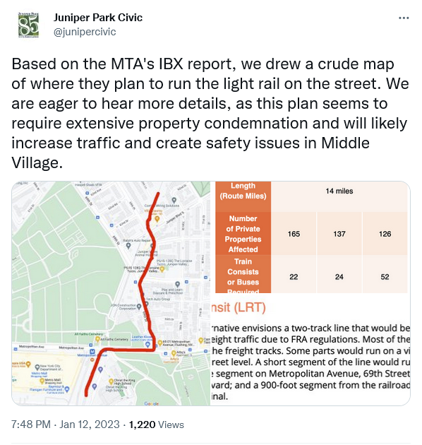
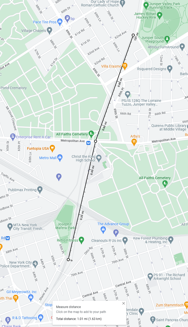
The tunnel under Metropolitan Ave, and the All Faiths Cemetery, is the Achilles Heel of the entire IBX. North of the East NY Tunnel, four tracks diverge at Myrtle Ave with two tracks continue north and two lead to the Fresh Pond Yard and the Lower Montauk Branch. The two tracks heading north tunnel under a short section of the All Faiths Cemetery. Both north and south of Metropolitan Ave the ROW for the NY Connecting RR is wide enough for four tracks. But the tunnel itself is only wide enough for two.
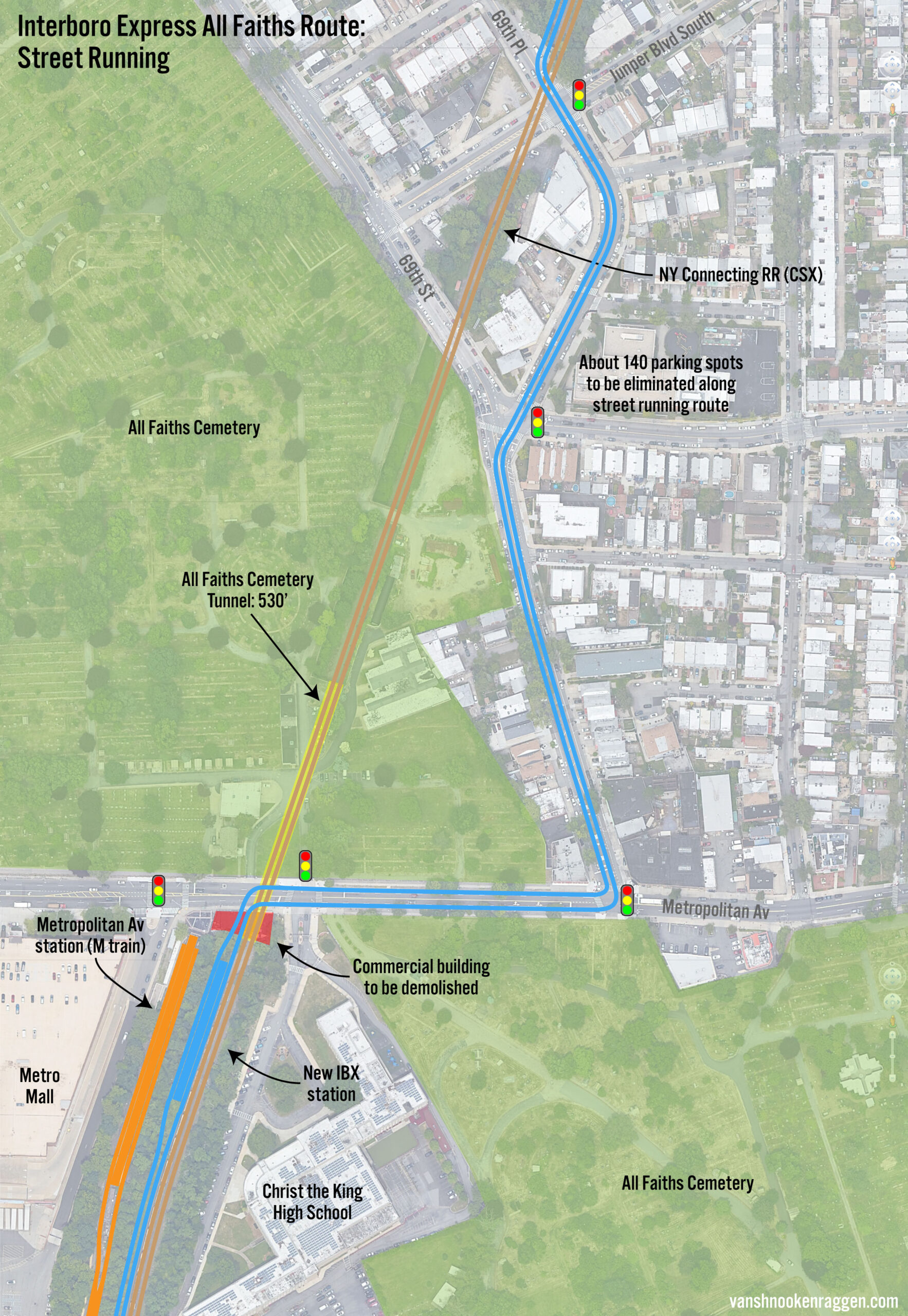
This is where planners were stuck with LRT. The All Faiths Tunnel is actively used as part of the Fresh Pond Yard to build trains. The yard is small and constrained, so freight ops require the use of this track to sort train cars before they are sent out of Long Island. Of all the places along the ROW where a second set of tracks is needed for passenger service, this is the most important.
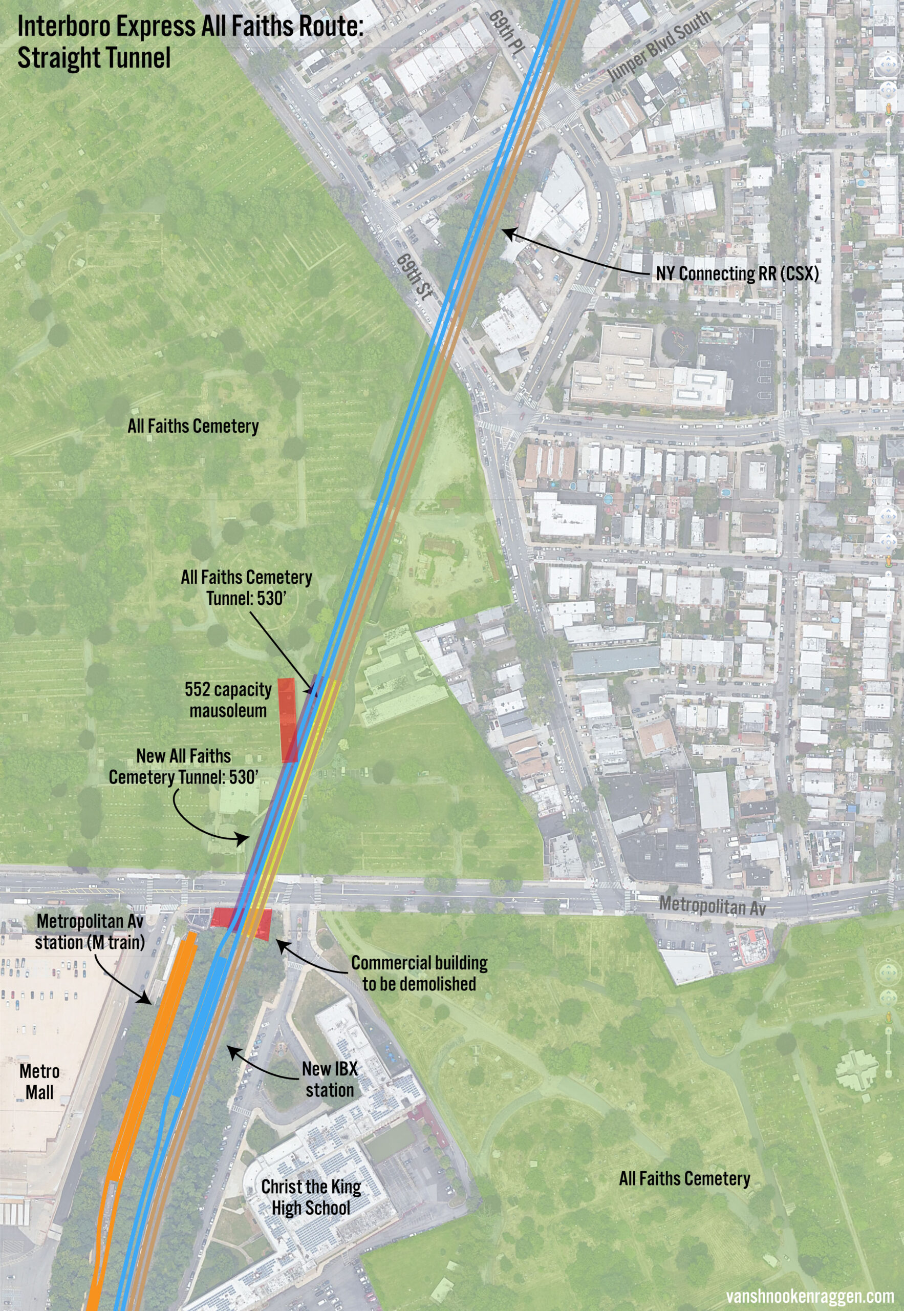
The plan is to have the LRT tracks run up on to the street and meander around the cemetery until they connect back with the ROW. CR could never do this, but LRT can, and in many cities, LRT lines have a combination of grade separation and street running. What kills this idea is that Metropolitan Ave, being the only east-west road in the area, is often choked with traffic. Requiring LRT vehicles to deal with gridlock, and then wind their way down narrow residential streets, is insanity. Planners claim that they would need to have a mile long tunnel running under the cemetery in order to keep trains off the street.
Cemeteries have been dug up for subways before, most famously the first subway in the US in Boston had to relocate bodies along Boylston St. Highways have been run through cemeteries and bodies moved. The MTA claims that a new tunnel would need to be a mile long, but this nonsense. The new tunnel could be built cut-and-cover style and wouldn’t have to move a single body.
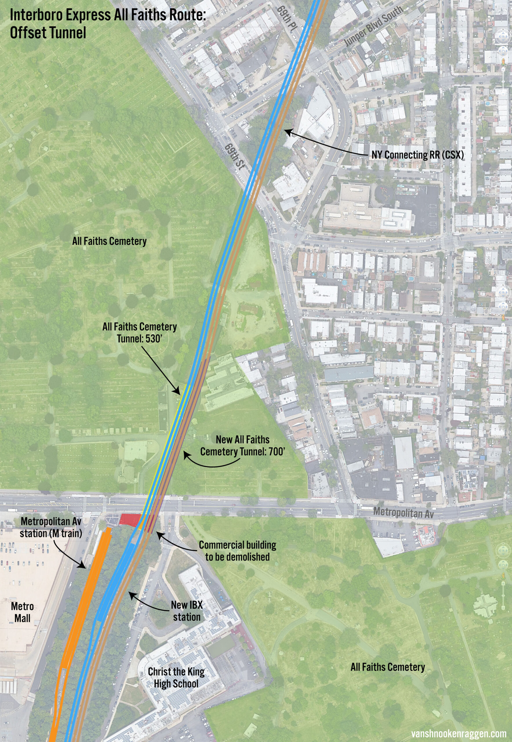
My guess here is that planners didn’t think they had the authority to make such a decision. A second tunnel, built to the right of the existing one, would not entail any body relocation at all. Their alternative was selected to move the project forward and set up a fight with local NIMBY groups, which would obviously oppose street running and set up a conversation with the cemetery. At least I hope that’s the case. If the MTA actually fights for street running here, we should fire everyone on the project.
[UPDATE 10/28/2024]
At the same press conference today, the MTA announced that it was moving forward with a shallow tunnel along side the All Faiths tunnel. While no details were released, it is likely that something similar to what I have outlined above will be considered.
The Bronx
Much has now been said about how the Bronx is getting shafted by this plan. The entire point of the original Triboro RX plan was to create a rail link between the Bronx and Queens. The MTA’s official reason is that with the combination of existing Amtrak, freight, and proposed Metro-North Penn Access and new freight services, there won’t be enough capacity on the Hell Gate Bridge to run IBX service with 5-minute headways.
Whether this is true will come down to how much freight service is going to be run. The IBX is being designed so that passenger and freight trains won’t mix at all. This is a choice, rather than a requirement. There are a number of LRT lines around the nation which have received wavers from the FRA to allow dual use, usually at different times of the day. This may be possible in the future if the Cross Harbor Rail Tunnel is never built, but we don’t now know what freight service levels will look like and if dual use is possible, until the IBX is built.
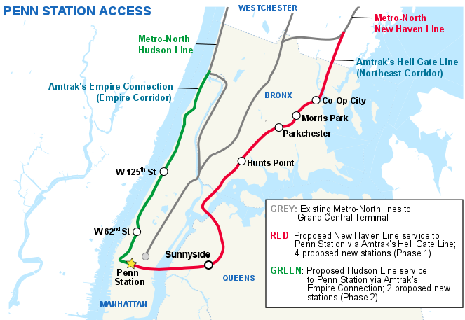
It’s also worth considering that the Penn Access project will serve the NEC through the northeast Bronx better than the IBX would. The IBX would require riders to transfer to the N/W at Ditmars Blvd which could potentially overload the already packed trains. But the MTA is failing at not providing a Metro-North stop somewhere in Queens. If built, this would create a Bronx-Queens rail connection for much cheaper than extending the IBX.
The MTA has said that it would consider a new infill station at Sunnyside Yards (space for such a station was left as part of East Side Access) but this is less than ideal in terms of connectivity. A better location would be at Northern Blvd where riders could transfer to the M/R trains. Just like with the IBX, the MTA is making poor planning choices which will kneecap the potential for these new connections.
Future LRT Lines?
I’ve been hearing people call for LRT in NYC for as long as I can remember. One entrepreneurial railfan almost brought streetcars back by himself! Now I am hearing folks say that many of the Select Bus Service (SBS) lines, NY’s half-hearted attempt at BRT, should be converted into light rail. But this blind love of trains is misguided.
What makes BRT work, if built correctly, is that it takes the benefits of a dedicated ROW and mixes it with the flexibility of buses which can use the city street network. The streetcars of yesteryear weren’t one-off lines, they existed in a network so that cars could all access the same yards and maintenance shops. The SBS lines in NYC are not connected, so if they were to be converted into LRT, each line would need their own shops and yards; an expensive proposal.
NYC has something that most cities don’t: a well-developed network of subway lines. For example, Utica Ave has seen proposals for a subway for over 100 years. It has one of the most popular SBS lines in the city, the B46. What’s the point of spending the money to install a LRT line along Utica Ave? At that point, build the damn subway!
Critics will point out that subway are more expensive to build, and rightfully so. But the construction cost problem is an entirely separate issue that LRT can’t totally solve. Transit equity is a problem with many different solutions. Focusing on one as a Swiss army knife isn’t sound planning. I would argue that almost any SBS line which is popular should be considered for a subway, not LRT. SBS, done right, is a more affordable and flexible service than LRT could ever be.
IBX to LGA?
Another idea I’ve seen batted around is that, since the IBX won’t go to the Bronx, why not extend it to LGA as a replacement for the now cancelled AirTrain? LRT or BRT are being considered by the Port Authority in their upcoming reassessment for LGA access.
IBX to LGA isn’t the worst idea, but it’s far from the best. Right now the Q70 SBS is a free non-stop bus connection between Roosevelt Ave-Jackson Heights station and the LGA terminals. It runs along the BQE and Grand Central Parkway, both roads which get choked with traffic at all hours of the day. The IBX could replace the Q70, running on a grade separated viaduct above the highway.
But with a station at Roosevelt Ave 600 feet away from the subway, it will be a worse connection than the Q70 today, which uses the bus terminal connected to the station complex. In this case, having separate BRT lanes would be a better, and cheaper option.
Additionally, the IBX would still require travelers to transfer to existing subway lines to complete their trip, which isn’t a better alternative to what riders have to do today. The ideal transit connection to LGA is to extend the BMT Astoria Line, the N/W trains. Some may point out that extending the elevated subway along city streets is a non-starter, but extending the IBX would require doing the same thing. Extending the N/W trains connects travelers more directly to the central business districts and hotel districts in Manhattan, while also providing connections to other subway lines at existing stations.
Politics is the art of compromise. Extending the IBX to LGA is the politically safe choice. It’s also not such a terrible one where it would be rejected outright.
Cost
Last year, MTA Chairman Janno Leiber was quoted as saying the IBX would cost “single digit billions.” As I said at the beginning of this post, my past issue with the Triboro RX plan was that the RPA made laughable claims that the entire line (from Bay Ridge to Co-op City) could be built for just $2 billion. Given the MTA’s track record, I figured the entire line would clock in just over $10 billion.
The final cost estimate for the LRT version of the IBX is said to be $5.5 billion, with the CR version, including miles of tunnels, at $8 billion. I’m curious to see how these costs break down, as the MTA has not released any detailed budget. When they released their Rockaway Beach Branch Feasibility Study in 2019, their extreme cost estimates could be countered since they were nice enough to provide a detailed budget. They are most likely not repeating the same mistake so that the costs cannot be countered.
The IBX is being designed very similarly to the recently opened Green Line Extension through Somerville, MA. That project famously had huge cost overruns which almost killed it before it broke ground. The GLX ended up costing $530 million per mile, which compared to the 2nd Ave Subway is a steal! But comparing that cost to the IBX, the New York project looks more like $7.4 billion.
Conclusion
Is the IBX (as LRT) a good idea? Absolutely. Is the IBX worth the cost? Most likely yes. The potential to create real outer borough connections without needing to go into Manhattan is all the value you need. Add on top of that serving a section of Brooklyn which sorely needs better transit, the cost makes it look better than Phase 2 of 2nd Ave. But the devil is in the details, and I fear that the MTA will make poor planning choices in an attempt to keep costs down that will end up costing them more in the long run.
Native Bostonian here, so I’ve got no dog in this fight, but just as a general comment on public works spending, the choice between upfront construction cost and long-term operating cost is always a difficult balance to strike. The taxpayers, having been burned many times before with cost overruns on public projects, often vote for the lowest upfront cost, even when the benefits of a slightly more ambitious (read: expensive) option are clear.
Even if there is support for spending more to improve utility, when overruns suck up the available funds, the money simply isn’t available, period! The most famous example I can think of in recent memory was the cancellation of the North-South Rail Link we were promised as part of the Big Dig. When costs on the Big Dig ballooned out of control, the North-South Rail Link died as part of the attempts to find the money to cover the additional cost of the Big Dig, even though Governor Dukakis was highly supportive of the Link. The Link still has broad public support, but ever since the Link was cancelled, finding the money to build it has been impossible to achieve, since no one wants to be blamed for another “money pit” when the costs skyrocket again!
It’s great to see the IBX making progress. I’m concerned though that it will prevent the L train being rerouted underground at Atlantic Avenue as I think that is also an important thing to do in my opinion
Well, if the IBX report is to be believed, then the East NY tunnel could haven never supported the L train. The L can still be extended under Van Sinderen Ave and there is room in the cut south of Atlantic for a below grade L train.
Do you see a possibility for the line to begin [call it stage 1] with 10 or 11 stations from BAT to Livonia avenue? It would connect a lot of trains and provide 3 communities with a station and thus access to the subway system.
Probably not. The reason is that they will have to do some serious earth moving through Midwood, so it’s not like this section would be so easy that they could start service sooner than later. That said, who knows what will happen.
While I agree that the biggest origin market for transit to LGA is likely Manhattan, I do want to push back a bit on the idea that the NW is necessarily better than a (admittedly hypothetical) good connection to the IBX / Jackson Heights.
Also because of the N/W’s missed connections in LIC, it’s probably likely that while many people get a one-seat ride to LGA through the N/W, many people (particularly in Brooklyn and Queens) will also still be stuck with two transfers (i.e., something to IBX to Q70, G to EFMR7 to Q70, etc.) to LGA.
IBX to LGA seems to ensure that almost everyone gets a 1-transfer ride to LGA, which would be superior in terms of transfer penalty to folks getting to JFK (unless you’re already on the AEJZ) or EWR
(people along stations that are only served by the G are kind of screwed either way, barring some unlikely and probably unstable return of the G to the Queens Blvd lines).
(this is all a bit moot, I do agree that the transfer at Roosevelt is not ideal. It would be easier if they could somehow build an in-system (or at least in-building) transfer – some travelator + escalators under the 7 tracks for example – but still.)