
Every borough of New York City has a great unrealized subway line. Manhattan (until recently) and the Bronx have the Second Avenue Subway; Phase 1 opened at the end of 2016, and Phase 2 recently broke ground. Brooklyn has the Utica Avenue Subway, which was recently included in the MTA’s 20-Year Needs Assessment. Staten Island… well, we know the story there.
If you were to narrow down a list of proposed Queens subway lines, which one would stand out as the most elusive? Perhaps it would be the Rockaway Beach Branch, which is a project close to my heart. But a part of the Rockaway Branch mostly does serve the borough of Queens, having been added to the subway system in 1956. While all that is missing is the northern extension, it’s still a semi-realized project.
Going back through old proposals, there is another corridor that keeps popping up. While concepts for new lines evolved substantially from the 1920s until the 1970s, a subway line along Horace Harding Blvd, today the Long Island Expressway, was always kept around in one form or another. The roadway sits almost equidistant between the IRT Flushing Line (7 train) in the north and the IND Hillside Ave Line (F train) in the south. It was always an important east-west artery, and the LIE today sees traffic levels approaching 200,000 vehicles per day.
While eastern Queens is known for being built out primarily with single-family detached homes, there are pockets of density that buck the typical suburban sprawl. Much of this density is still in the form of modernist “towers in the park” promoted by the famed architect Le Corbusier. These large-scale developments sit like pearls, connected by the string of the Long Island Expressway. A transit line along this necklace still haunts the dreams of planners and railfans today.

Who Was Horace Harding?
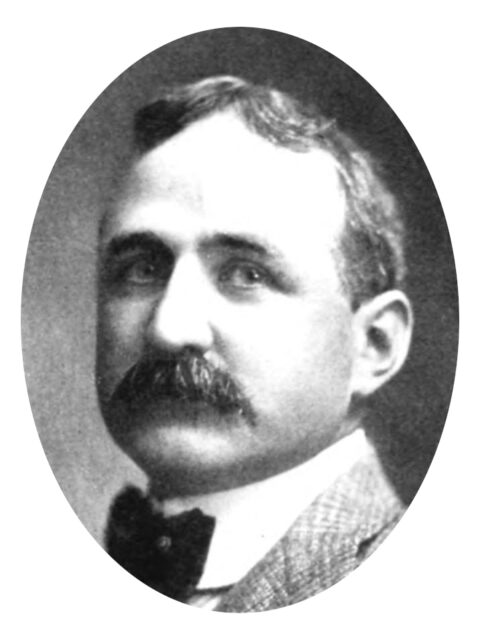
James Horace Harding, who is not related to former president Warren G., was a Philadelphia-born banker who came to prominence at the turn of the century. Building his fortune in the Gilded Age, Harding spent his money on the typical trappings of financiers of the day. This included the sport of golf, of which Harding was a dedicated devotee. He was a member of the Oakland County Club in eastern Queens.
Eastern Queens after the turn of the century was very rural, with large farms and small towns connected by narrow dirt roads. Older settlements like Flushing and Jamaica were the largest developed areas at the time, and even these were no more than large towns. When the Pennsylvania Railroad connected the LIRR directly into Midtown Manhattan in 1913, the far-flung farms of Queens suddenly became more accessible. By the end of the decade, new subway lines were turning areas closer to Manhattan into residential neighborhoods dominated by garden apartments. Areas that remained harder to reach were left to the ultra-rich, who could afford private transportation to their secluded villas and country clubs.
The Oakland Country Club was located at the eastern edge of Queens County, near the tony estates of the Gold Coast, and accessible by the Long Island Motor Parkway. Cars at this time were the playthings of the rich, who were able to finance their own private roads where they could take their state-of-the-art machines out for races.
Horace Harding saw these roads in more practical terms. He saw how cars could allow residents an escape from the city. Harding was particularly supportive of a young planner by the name of Robert Moses, whose vision of expansive parkways throughout Long Island mirrored his own. Harding may not have had the funding to open the vast reaches of Long Island to city residents, but he did have enough to build a modest boulevard that would connect the new Queens Boulevard (which reached Manhattan via the recently completed Queensborough Bridge) to the Oakland Country Club. This new road was named Nassau Blvd, as it would also reach the border with Nassau County.
Unfortunately for Harding, he did not live long enough to use his new road. Nassau Blvd fully opened in 1928, but Harding died in January of 1929. Bad luck for his dreams, but at least he didn’t live long enough to lose his fortune in the stock market collapse later that year. In May of 1929, Nassau Blvd was renamed in his honor to Horace Harding Blvd, although a small section near Little Neck Parkway on the very eastern edge of Queens still retains the original name.
Transit Plans
Even though he had financed a new road, Horace Harding also had connections with railroads and transit. At various times in his career, Harding was chairman of a number of companies, including the Public Service Corporation of New Jersey (the predecessor of today’s New Jersey Transit), the Southern Pacific Railroad, the Ann Arbor Railroad, the New York New Haven and Hartford Railroad, the New York, Ontario and Western Railway, the Wabash Railway, and the New York Municipal Railways System.

The New York Municipal Railway was formed in 1912 by the Brooklyn Rapid Transit Company to build Contract 4 of the Dual Contracts and lease them to the city. Contract 4 built out the “new” lines of the BRT. This included the Broadway Line (N,Q,R,W trains), the Centre St Loop (J/Z trains), Eastern District Line (L train), 4th Ave Line (N,D,R), and former steam railroads in southern Brooklyn which were either elevated (West End, Culver), or rebuilt into a cut (Sea Beach).
The two new subway lines built in northern Queens, the Astoria Line and Flushing Line, brought immediate residential growth to the borough. This growth made planners realize that additional lines would be needed sooner rather than later. As part of the next phase of subway expansion, now being driven exclusively by the city through their Independent Subway System (IND), a massive new 4-track trunk line was being planned, along with a new arterial highway, Queens Boulevard, which would sit on top of the tunnel.
The Queens Blvd Subway Line (QBL) was designed to attract existing riders in Astoria and Woodside, near the IRT and BMT lines, while opening up areas parallel to the LIRR Main Line to Jamaica for development. A number of future branches were planned, most notably to connect with the LIRR Rockaway Beach Branch and a branch along Van Wyck Blvd (which was eventually used for the Archer Ave Line). However, even though the subway was being built at the same time as Horace Harding Blvd, no branch was planned along the boulevard.
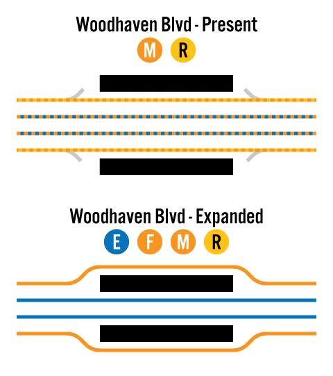
Planners likely saw that residential growth along Horace Harding Blvd would take longer than growth closer to Manhattan. The IND was legally required to start making money within 3 years of opening, so the focus was on building along established corridors. Jamaica was a major hub for commerce and transportation, so it made sense to focus future branches there. The Rockaway Line already existed and created a north-south backbone through the borough. Horace Harding Blvd would likely be a major feeder route for new bus lines. IND planners planned for this by building the local Woodhaven Blvd station, located at the beginning of the road, in such a way that it could be easily expanded into an express station in the future.
1930s
By the end of 1929, the IND had yet to even open its first line (8th Ave), but it published a plan for the next phase. This plan, known forever as the IND Second System, primarily revolved around the Second Avenue Subway and the gargantuan South 4th Street Subway in Williamsburg, which truncated a number of new subways along Utica Ave to Marine Park and Myrtle Ave to Ozone Park and Rockaway.
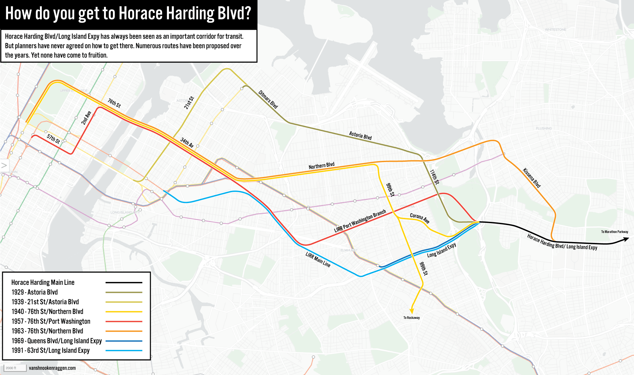
In northern Queens, extensions of the existing IRT/BMT lines (both the Astoria and Flushing Lines were run by a joint operation between both companies) rather than new IND lines were proposed. Even though the Flushing Line was much closer to Horace Harding Blvd, the line could not support a branch before Main St in Flushing due to demand. Plans instead called for an extension to Bayside and College Point. Therefore, an extension of the Astoria Line was proposed.
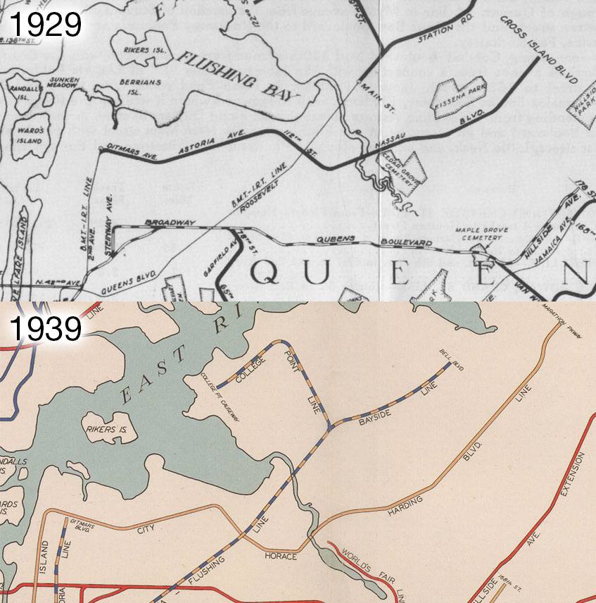
The Astoria Line terminates just south of the intersection of 31st St and Ditmars Blvd so that the tracks can make the curve east along the boulevard. This extension would then move to Astoria Blvd in East Elmhurst before turning south along 112th St in Corona. At Corona Ave, the line would turn east again along Horace Harding Blvd, running to Cross Island Blvd (today, Francis Lewis Blvd). From a service standpoint, such an extension was feasible, just not all that practical. The Astoria Line has a single express track from 39th St Ave to Astoria Blvd. This track would have supported peak-direction express service, but the route would have still been rather long.
By 1939, an additional connection to the Astoria Line extension was proposed. A 2-track tunnel branching off the 60th St Tunnel along 21st St would have acted as an express-bypass for the Astoria Line. Along Ditmars Blvd, the 2-track elevated line would have met with a ramp down to the 2-track subway, where the subway would come above ground and run as the middle express tracks of a new 4-track elevated line. The line would follow the same course through East Elmhurst and Corona to Horace Harding Blvd. At some point along Horace Harding Blvd, the local tracks would terminate, and the express tracks would continue east to Marathon Parkway.
1940s
In 1940, the private subway companies threw in the towel and were purchased by the City of New York. This meant that the Board of Transportation could plan to combine service on lines that were once competing with one another. The 60th St Tunnel connection planned for the Astoria Line was shifted to the QBL as a cheaper and faster way to add additional service to the crowded line. Plans for an Astoria Line extension were changed to serve the newly opened LaGuardia Airport.
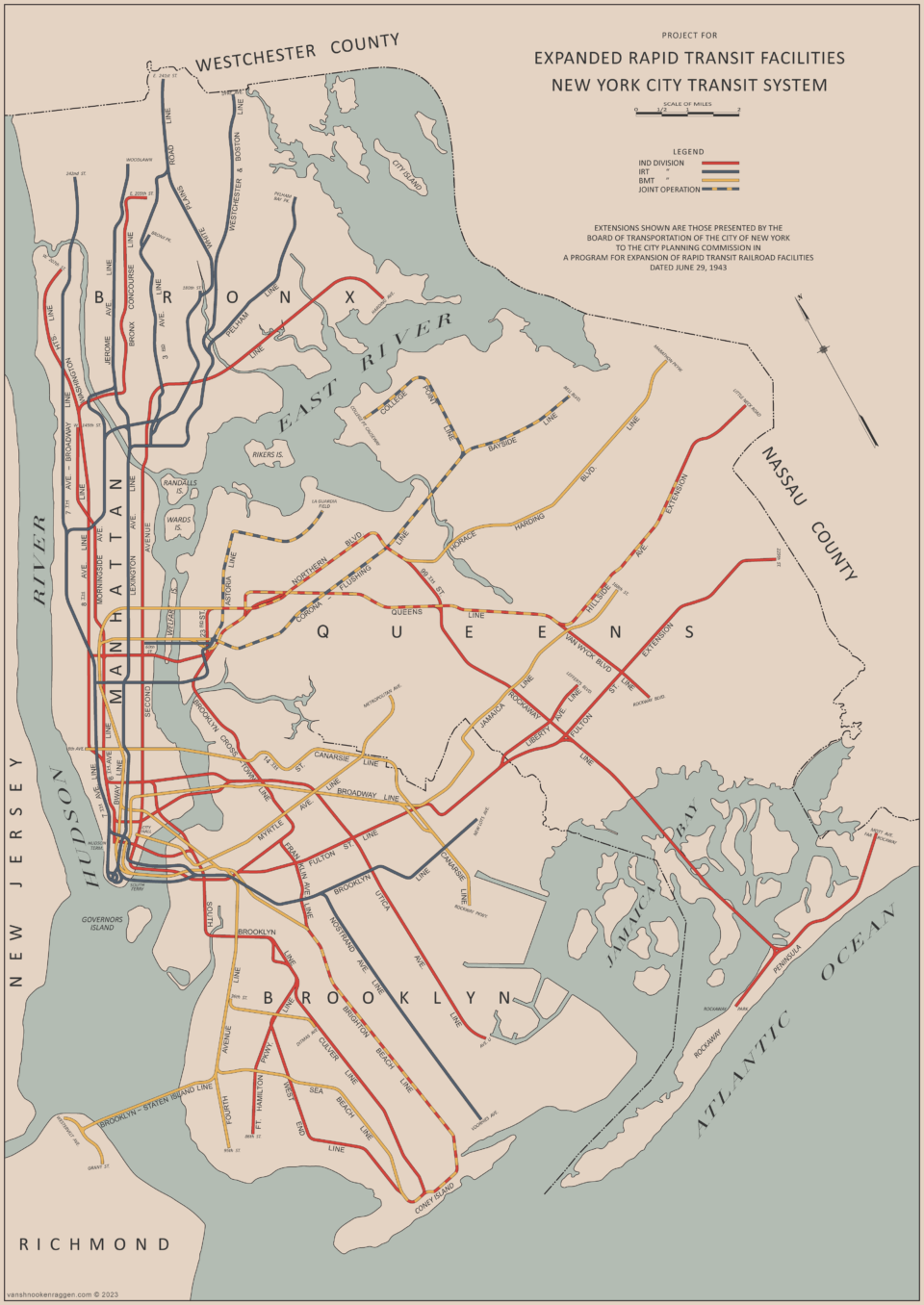
The Horace Harding Blvd Line was still proposed, but it would now be a much more ambitious project. Starting at 7th Ave and 59th St, the express tracks of the BMT Broadway Line were to be extended north, under Central Park, to 72nd St, then along 72nd St and under the East River to 36th Ave in Long Island City. At 23rd St and 36th Ave, the 2 tracks would expand to 4 tracks, and an extension of the IND Crosstown Line (which would branch off the main line between 21st St and Court Sq) would join the subway. The 4-track trunk line would continue along 36th Ave to Northern Blvd, then run either under the existing subway there or possibly the LIRR in Sunnyside Yards to Broadway and Northern Blvd.
The subway would continue along Northern Blvd, turning south at 99th St to Corona Ave. At Corona Ave, 2 tracks would branch off and continue south along 99th Ave, under Queens Blvd at 66th Ave, and come above ground to connect with the Rockaway Beach Branch. Back at Corona Ave, 4 tracks would continue along Corona Ave to Horace Harding Blvd. A large yard and maintenance facility for the line would be constructed in Flushing Meadows-Corona Park. 2 tracks would continue along Horace Harding Blvd out to Marathon Parkway. The plan was ambitious, to say the least. But it would serve Jackson Heights better than an extension of the Astoria Line, providing a more direct route into Midtown Manhattan.
During World War II all development of the subways ceased. John Delaney, head of the Board of Transportation from its inception, kept the dreams of the Roaring Twenties alive. But with his retirement in 1945, new leadership had a more sober view. Gone were the complex and overly expensive connections and new lines. The post-war economic reality meant that city funds were virtually exhausted, and those that were available for construction were quickly being used for new arterial highways instead.
A post-war plan for expansion kept only a handful of proposals from the pre-war days. A connection between the 60th St Tunnel and the QBL was kept. A new East River tunnel was proposed at 76th St that would allow for a connection to and takeover of the LIRR Port Washington and Rockaway Branches. Instead of new lines, the city focused on creating new connections within the network to provide more service to growing areas. But unlike before the war, highways were the drivers of residential growth. Worse, the subways had suffered from decades of deferred maintenance due to the legally sacred 5-cent fare and wartime rationing. If new lines were going to be built, they had to be cheap.
1950s
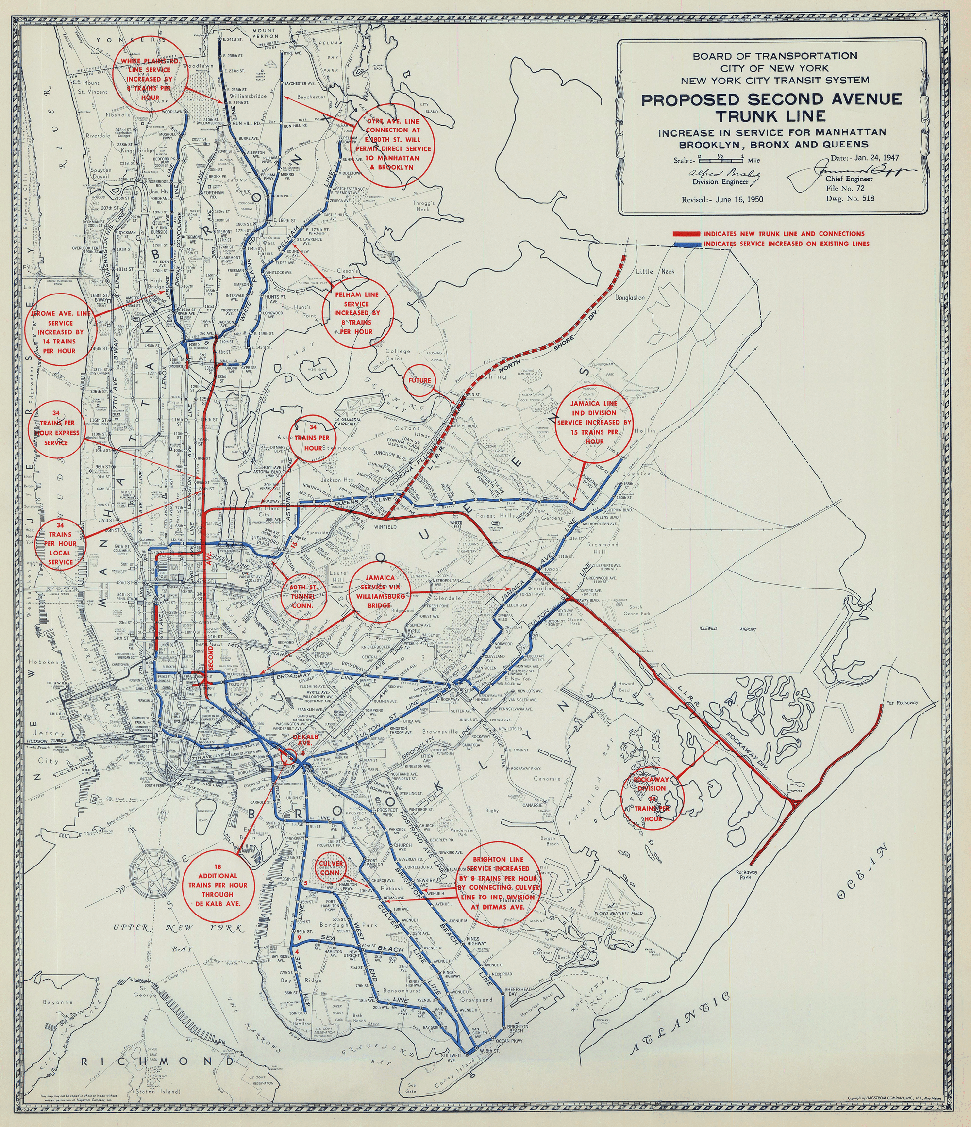
The Board of Transportation, a city agency, was unable to float debt for expansion on its own, and the city was maxed out. In 1950, the city proposed a $500 million ($6.7 billion in 2025) bond act, supported by doubling the subway fare to 10-cents, which would fund subway improvements (maintenance, platform extensions, and new trains) as well as the Second Avenue Subway. But what the public didn’t know was that this would never have been enough for new subway lines, as the existing network needed far more investment than previously known.
Only a handful of projects were funded through the bond act, namely the extension of the IND Hillside Ave Line (F train) from 169th St to 179th St, a track connection between the Dyre Ave Line and the IRT at 180th St (5 train), and the 60th St-QBL connection (R train), which provided much-needed local service on the QBL. The largest expansion came from the city purchasing the defunct LIRR Rockaway Beach Branch, but there weren’t enough funds to rehabilitate the line for service. The rest of the bond money was diverted by Robert Moses into new roads.
With the city credit maxed out, expansion was at a standstill. The solution came in the form of the New York City Transit Authority (NYCTA), a public authority that was legally able to float bonds for capital construction. In 1953, the Board of Transportation was dissolved, and the NYCTA took over with the aim to finally fix what the city couldn’t. Immediately the NYCTA set to work on major reconstruction of lines and building new extensions. The IND South Brooklyn Line (F, G trains) which had opened in 1933, was finally connected to the BMT Culver Line in 1954. In 1956, the Rockaway Line was fixed up and connected to the IND Fulton St Line. Plans to connect the Rockaway Branch to the QBL were considered at this time, but the lack of existing capacity on the subway meant that there were no additional trains to send down there, and the northern extension of the Rockaway Line sits abandoned to this day.
Even though the Rockaway Line represented the largest expansion of the New York subway in 16 years, it wasn’t serving areas that had seen the most growth over that same time. Southern Queens had older housing stock and longer travel times to the growing commercial center of Midtown Manhattan. Northern Queens, on the other hand, had more room to grow, had newer housing stock built after the subways had arrived, and had fast, direct access to Midtown.
Horace Harding Expressway
Even before World War II, engineers and planners were dreaming up schemes that involved building new grade-separated highways with rail transit along their medians. The thinking went, if new rail lines and modern roads were expensive to build, then why not combine them into one to save on ROW costs? Transit would soak up many of the cars that would use the road, adding to their overall capacity. But after the war, commuters began ditching railroads, which were seen as old-fashioned and dirty, for cars and modern highways, which were seen as the future. This trend had begun before the war but accelerated once oil and gas rationing during the war was lifted. Railroads and transit were thought of as private, for-profit companies that had been fleecing riders for years. Cars were a more flexible, personal alternative.
The most successful example of this dual-use project is in Chicago, which built three of its major interstate highways with wide medians for rail transit lines. From an academic standpoint, this works well. From a rider standpoint, it’s less than ideal; the rider is forced to walk greater distances to reach the station, only to be standing in a cloud of car exhaust. From a neighborhood standpoint, it’s the worst trade-off. More of an existing neighborhood needs to be demolished to build the extra space for transit, and the walkable locations that transit is best suited to serve are now a memory.
Much is known today about how Moses made his parkway bridges too low for buses or how he refused to allow rail transit to be built along his highways. Had Moses built the Van Wyck Expressway wide enough for a rail line down the median, we could have had a direct subway between Manhattan and JFK Airport. Moses claimed this would cost too much, saying that it would require taking more homes along the route. This hadn’t stopped him before.
Day & Zimmermann Report
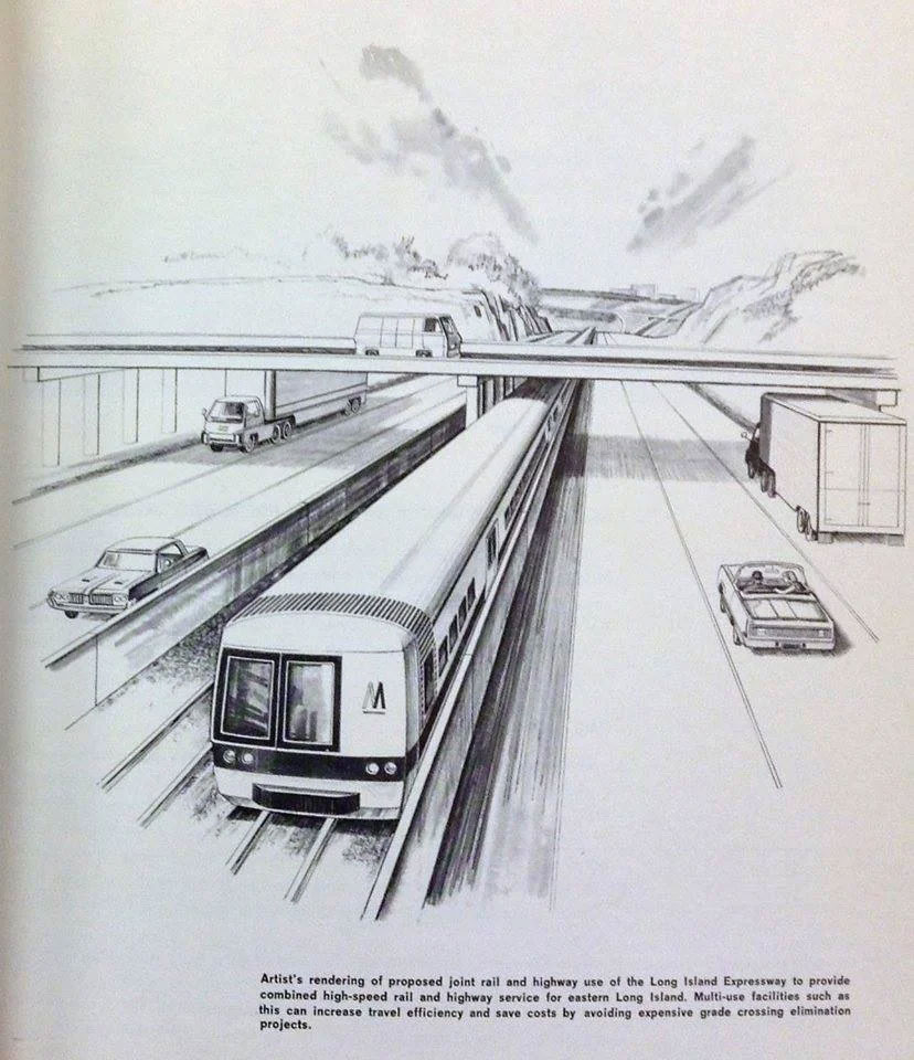
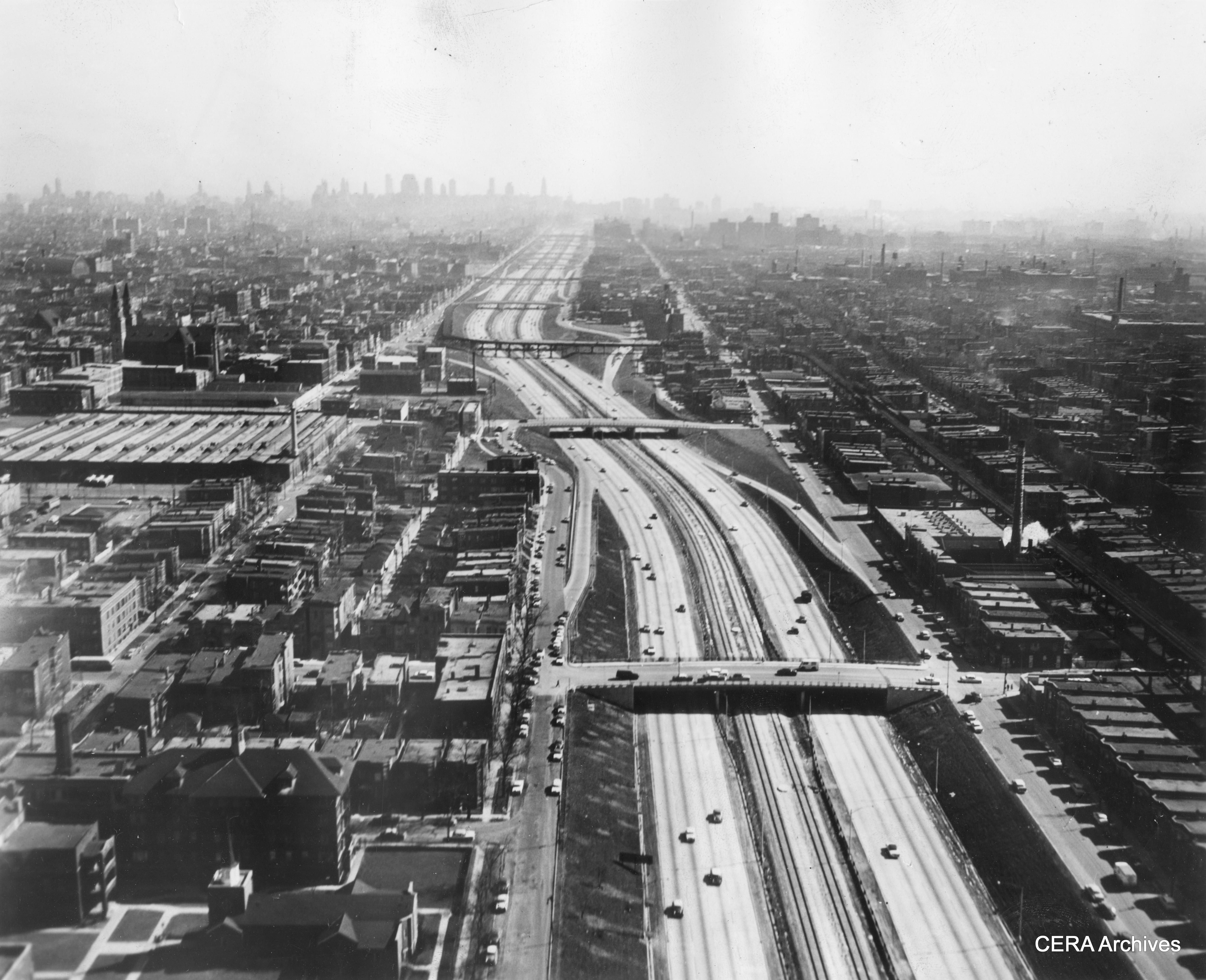
The Long Island Expressway broke ground in 1954. It was designed to connect the Queens-Midtown Tunnel (QMT) in Hunterspoint, Queens, with Riverhead in Suffolk County. The route from the entrance of the QMT to Queens Blvd required cutting a path through Maspeth and Middle Village, removing hundreds of homes and businesses. From Queens Blvd to Nassau County, Moses expanded Horace Harding Blvd, sinking the middle lanes below grade and expanding the outer roadways as frontage roads. To this day, the main roadway is called the Long Island Expressway, while the surface roads are still known as the Horace Harding Expressway.
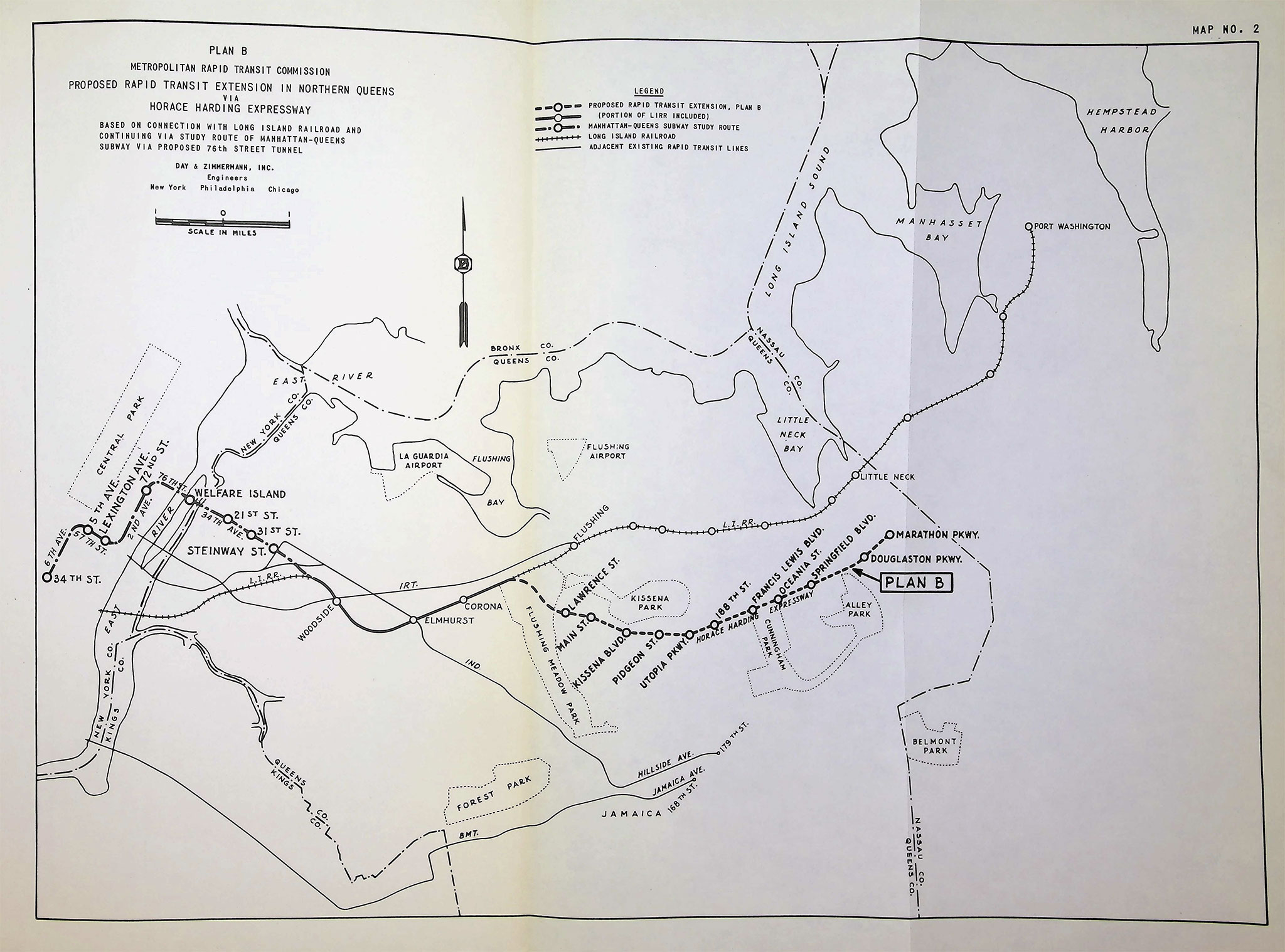
While the road was still under construction, the New York–New Jersey Metropolitan Rapid Transit Commission, a bi-state commission set up to explore new transit solutions for the region, commissioned the consulting firm Day & Zimmermann of Philadelphia to conduct a study on the possibility of a rail transit line along the median of the LIE. The study looked at three options for such a route:
- Plan A: Using a new tunnel from 76th St and 2nd Ave in Manhattan to 36th Ave in Queens, the new line would take over the LIRR Port Washington Branch, converting it to subway operations with a subway fare.
- Plan B: Using the same tunnel, the new line would run along the LIRR Port Washington Branch to Flushing Meadows-Corona Park, where it would turn south and connect to the median of the new LIE, running out to Marathon Pkwy. There would be 11 new stations at key cross streets, which would feature large park-and-ride garages.
- Plan C: A new branch off the IRT Flushing Line after 111th St to the median of the LIE, with the same station configuration.
The report (read the entire report here) concluded that none of the options would be self-supporting. The conversion of the Port Washington Branch would be less of a financial strain on the city, but a line along the LIE would be “superior in matters of public benefits, including the avoidance of disadvantages to present railroad passengers with respect to increased triangle time.” The report goes on to say, “However, at the present stage of planning and actual construction on the Horace Harding Expressway, we do not believe that construction of a rapid transit line on this highway would be practicable.”
This conclusion is based on the fact that with no space available for rail along the median of the highway, a new subway would need to be built at a much higher cost. A new tunnel under the East River would add to the high cost, and a branch off the IRT Flushing Line would likely not have saved much time or added much comfort given the existing service.
1960s
With falling ridership bringing falling revenue, NYCTA began to face the same financial strains as the Board of Transportation before it. In the early 1960s, planners still held out hope that a new wave of expansion into the suburbs could stem the tide. If new subways could be built with further station spacing, the expensive 4-track trunk lines could be built at half the cost with only 2 tracks. With stations spaced further apart, trains could reach higher speeds, bringing travel times down.
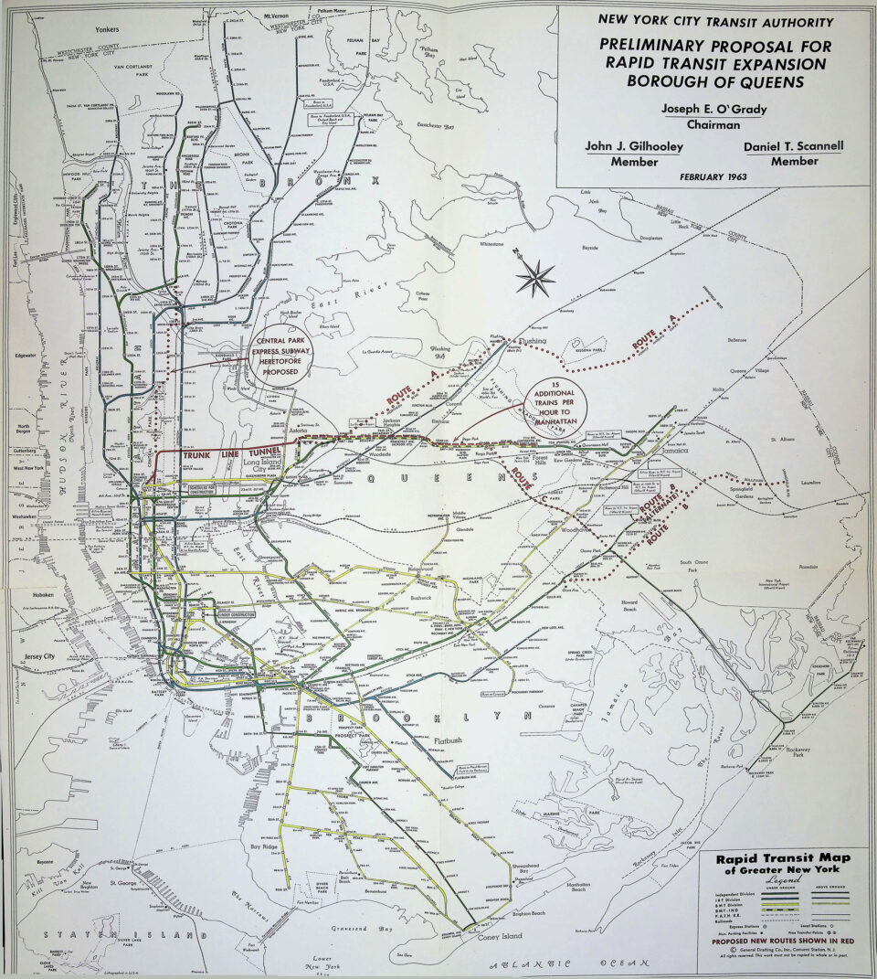
In 1963, NYCTA proposed a new program of expansion (read the full report here), mostly aimed at Queens. Unlike the plans going back to 1929, this was the first expansion program that did not include the Second Avenue Subway. Instead, the program was based on a new East River tunnel along 76th St that would connect both the Broadway and 6th Ave Lines to the QBL at Broadway. Initially, only 15 trains per hour (TPH) would run along the line to supplement local service on the QBL. Once operational, three new extensions would be added.
- Route A would branch off the new tunnel at Steinway St, running to and along Northern Blvd to Main St in Flushing. The branch would turn south along Main St and Kissena Blvd, turning east along the LIE to Springfield Blvd.
- Route B would extend the IND Fulton St Line from the provisions left past Euclid Ave, along Linden Blvd to Merrick Blvd, and south along there to Springfield Blvd.
- Route C would reactivate the northern portion of the Rockaway Beach Branch with a connection to the QBL at 63rd Dr-Rego Park.
In addition to these new Queens lines, an express-bypass subway under Central Park to Harlem and the Bronx was proposed. This 2-track line would extend from 6th Ave as well (with a transfer station between Bronx and Queens trains under Central Park… in the middle of the park), running north to Central Park North and 5th Ave before crossing the Harlem River. In the Bronx, the main line would connect directly to the 3-track IND Concourse Line, providing additional local and express service. A single track would branch off at 138th St and connect to the middle track of the IRT Pelham Line. By cutting back the platform edges at the express stations, B-Division trains would provide peak-express service on the A-Division Pelham Line. Broadway Express (N,Q trains) serve Queens, while new 6th Ave Local service would serve the Bronx. Both of these connections were to take advantage of the then-under-construction Chrystie St Connection and DeKalb Interlocking reconstruction, which were to provide more service coming in from Brooklyn.
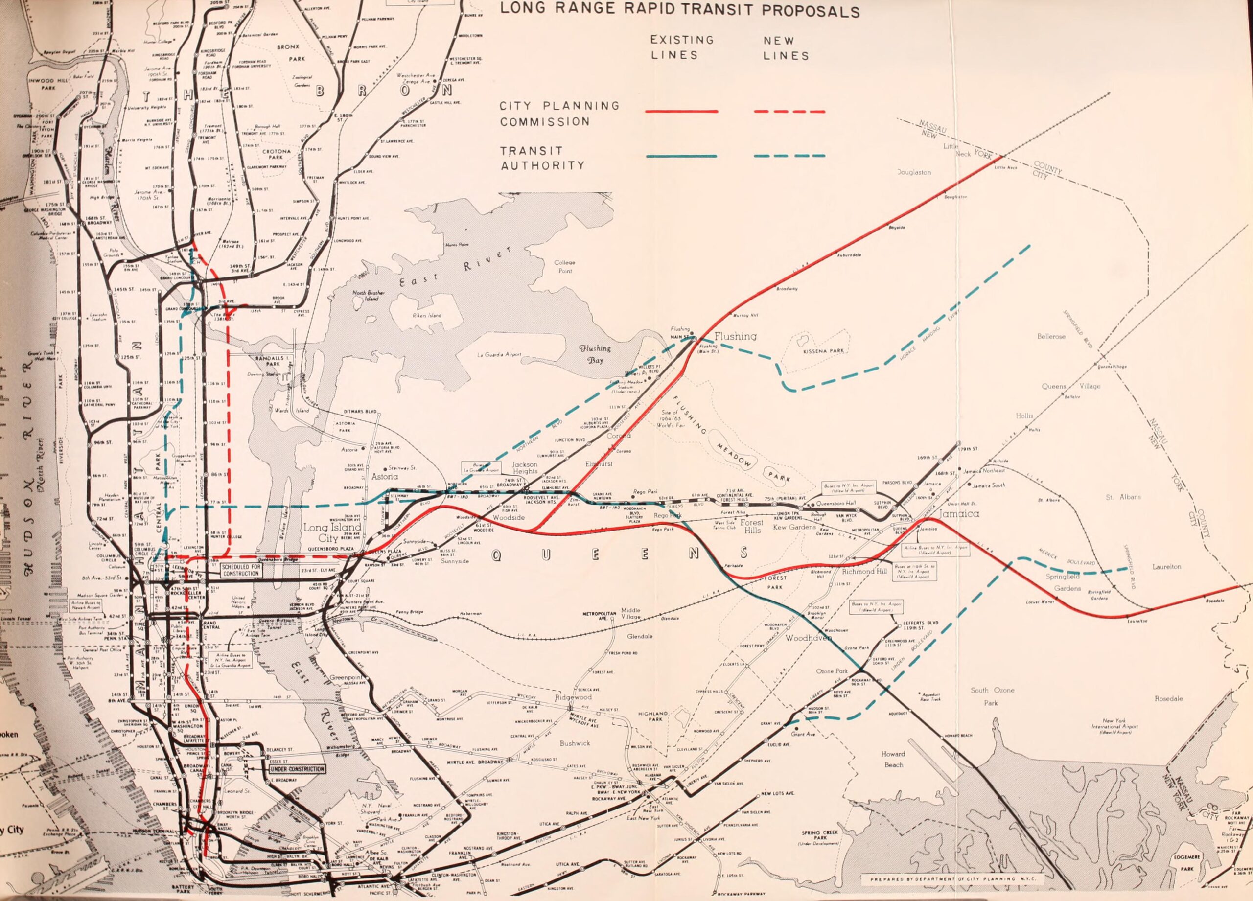
The City Planning Commission, however, saw these plans and found them wanting. A new East River tunnel, they claimed, should be located closer to Midtown for a more direct route. Additionally, there were those who wanted to see this new tunnel also serve the LIRR, which would be routed into Grand Central Terminal. The new routes in Queens required expensive new tunnels, when using underutilized LIRR lines could serve the borough just as well for much less. Finally, the Central Park express-bypass would bypass dense neighborhoods that had seen their elevated transit lines demolished with the promise of replacement by the Second Ave Subway.
MTA and the Program for Action
By the late 1960s, it was clear that the highway-only approach to city building was not working out. While other major US cities were planning and building alternative mass transit systems, Robert Moses controlled the reins of local and federal funding in New York, making any mass transit solution all but impossible. The story of how Gov. Nelson Rockefeller ultimately tricked Robert Moses into giving up his power has been told before. What’s important to understand for our purposes is that it was assumed that the Metropolitan Transportation Authority, which was tasked with taking over the NYCTA, could reinvest the toll revenue from the Moses-run Triborough Bridge and Tunnel Authority into the subways.
Even before the ink was dry on the new arrangement, the MTA planners had begun developing a massive new program of rehabilitation and expansion. The crux of the new program for expansion was a new 4-track tunnel along 63rd St between Manhattan and Queens. The MTA and city had agreed to the location of the tunnel after a lower level for the LIRR was included, and geological tests indicated that it would be cheaper to build near 63rd St. Like the previous NYCTA proposal, the 63rd St Tunnel would connect the Broadway Express and 6th Ave Local tracks to the new crossing. But unlike the previous plans, the Central Park express bypass was replaced with the Second Avenue Subway.
In Queens, the 63rd St Tunnel was going to first connect directly to the QBL at Northern Blvd and 41st Ave, just north of Queens Plaza. This was to provide both express and local service to the main line of the QBL. A branch would then be built from this location, under Sunnyside Yards, to a location alongside the LIRR Main Line through Woodside. Using space along the LIRR, a single track would be built along the LIRR out to Rego Park, where it would dive back underground to Forest Hills-71 Av station to provide extra peak-express service. The new local service along QBL added by the 63rd St Tunnel would branch off at 63rd Dr-Rego Park, connecting with the now-abandoned northern section of Rockaway Beach Branch, which would then connect to the LIRR Lower Montauk Line through Forest Park. This line would continue through Jamaica, taking over the LIRR Atlantic Branch to Sprigfield Blvd in Laurelton.
The added express service through 63rd St would run out to Woodhaven Blvd, which would be expanded into an express station, then branch off along a new subway alongside the LIE out to Springfield Blvd. The 1940s IND plans had come full circle.
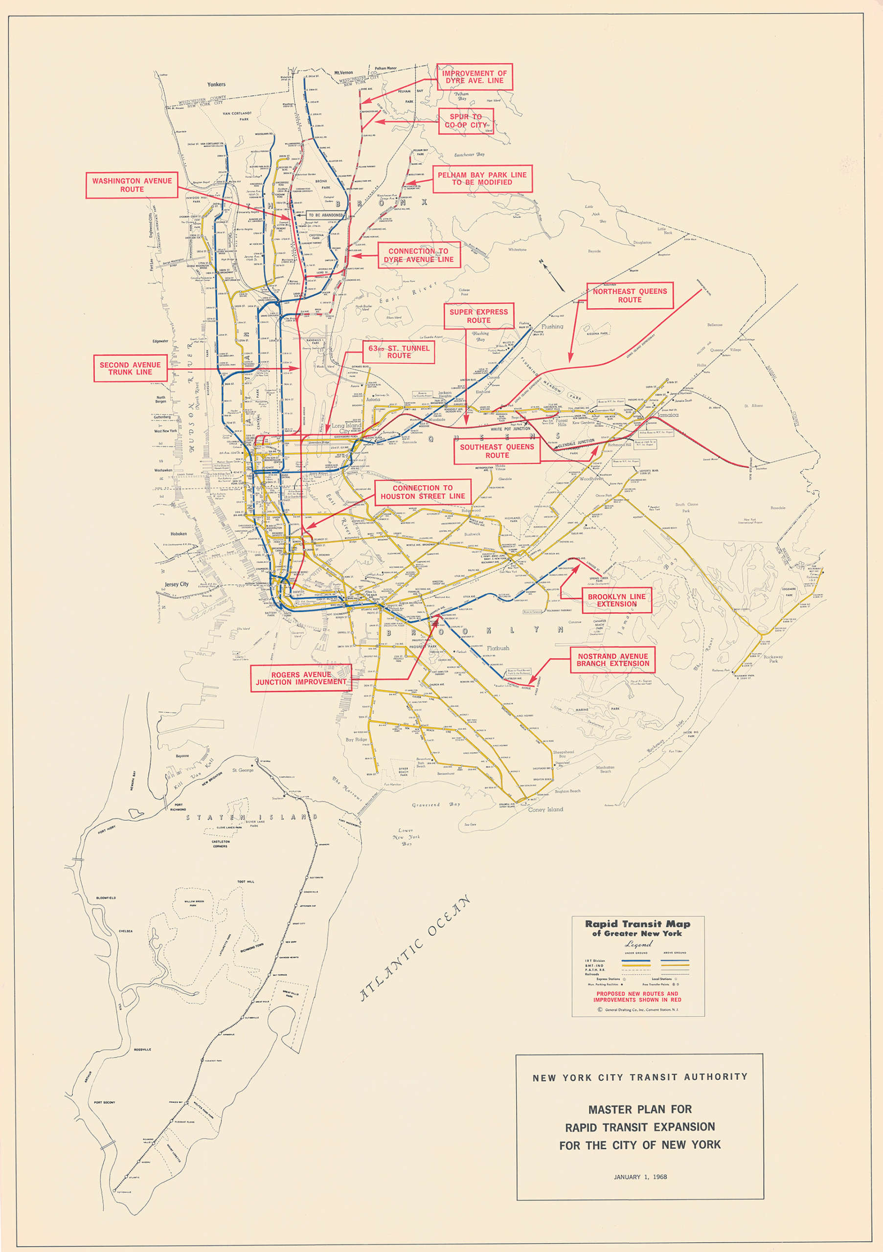
After negotiations with the city, the MTA evolved their earlier plans. Initial Second Ave Subway plans called for a 4-track trunk line. But the City Planning Commission recommended that the subway be condensed to 2 tracks, with wider station spacing to save money. The single-track Queens express-bypass line was expanded into 2 tracks for full-time service. The Rockaway Branch-Lower Montauk Line was removed. Now, the MTA would use the old IND provisions for a line along Van Wyck Blvd (now, Expressway) for a new subway under Archer Ave in Jamaica instead.
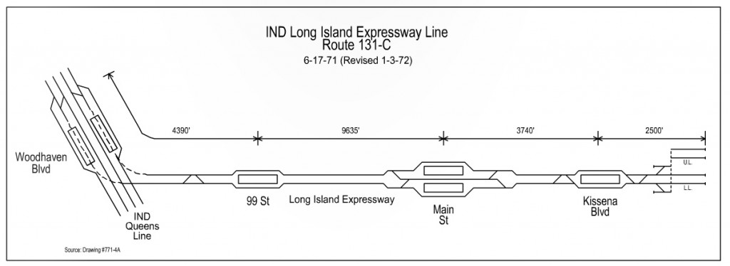
The subway along the LIE was christened the “Northeast Queens Route.” At this time, the NYS DOT was looking at ways to expand the expressway, which was already running at full capacity. If the DOT was going to expand the roadway, then space could be created for a subway either down the median or under the service roads. The two projects would be planned and built together to save money. An initial phase would see stations at 99th St-LeFrak City, Main St, and Kissena Blvd, where storage tracks would provide for a future extension to Springfield Blvd.
Construction on the 63rd St Tunnel began on November 24th, 1969. In 1972, the MTA held a number of groundbreakings for the Second Ave Subway, and in 1973, work started on the Archer Ave Line. But the optimism of the late 1960s had given way to the grim realities of the 1970s. The tolls that Gov. Rockefeller had hoped would pay for new subways turned out to be far less than what was needed. The subway system was in complete disrepair from years of deferred maintenance, while transit workers were demanding higher pay and more police in the system. The finances of the city were in shambles after generations of mismanagement. Inflation after President Nixon took the nation off the gold standard shot construction costs through the roof.
Publicly, the MTA said all was well. Some projects would need to be pushed back, but most of the ones already under construction would be open by the early 1980s. Internally, lines were already being cut. The Northeast Queens Route was likely one of the first to go. It depended on the 63rd St Tunnel providing the added capacity, and construction had run into a number of delays and cost overruns. The Archer Ave Lines could technically open sooner, rerouting existing lines, but the extension south to Springfield Blvd was pushed off indefinitely. The super-express bypass was a nice idea, but it too relied on the 63rd St Tunnel.
In 1975, work on the Second Ave Subway was halted. Work on the 63rd St Tunnel and Archer Ave Line limped along, mostly because they had been built using federal funds that would need to be repaid if the projects were canceled. The 63rd St Tunnel and Archer Ave Line did not see service until 1988, and even then, the 63rd St Tunnel didn’t actually connect with anything. It just ended at a blank wall, not even a station, north of Queens Plaza.
In the 1980s and 1990s, the MTA undertook a series of studies aimed at what they should do with the 63rd St Tunnel. A number of alternatives were considered, but most were discarded. The super-express bypass was one such idea whose time had passed. Ultimately, the MTA chose to connect the 63rd St Tunnel to the QBL in a way that would provide more express and local service. However, without the branches proposed in previous programs (either Rockaway or LIE), there was not enough outlet capacity for enough service to make the tunnel as useful as it could be. Even today, the 63rd St Tunnel runs at less than 50% capacity, and this will reduce further when the F and M trains flip in December.
The New Long Island Expressway Line
While other corridors once eyed for new subway lines have developed in the typical low-density suburban style, the LIE corridor has seen some of the largest, densest developments in the city. Starting along Queens Blvd. There are a number of large malls and office buildings along the corridor. High-rise apartment buildings have cropped up in the last few decades, but these were pre-dated by the massive LeFrak City, built in the 1960s. East of the Van Wyck Expressway, the LIE corridor hosts a number of large housing developments, as well as two city colleges.
Reading through the previous proposals for a rail transit line along the LIE, it’s clear that besides an at-grade line along the median of the expressway, only a subway in a tunnel was considered. It’s interesting to note that even though new metro systems being built at the same time were employing concrete aerial guideways, New Yorkers were still stuck in the mindset that an elevated subway would be dark and loud like the elevated structures they were used to.
Tunneling under the LIE poses a number of challenges. The area through LeFrak City was marshland until after World War II, when it was used for temporary housing. LeFrak City was the first real development on the site. Famously, Flushing Meadows-Corona Park was a trash dump until Robert Moses transformed it into a park. Even today, however, the park suffers from poor drainage. Building a tunnel through this terrain is not impossible, just more expensive.
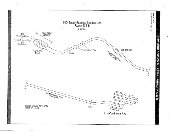
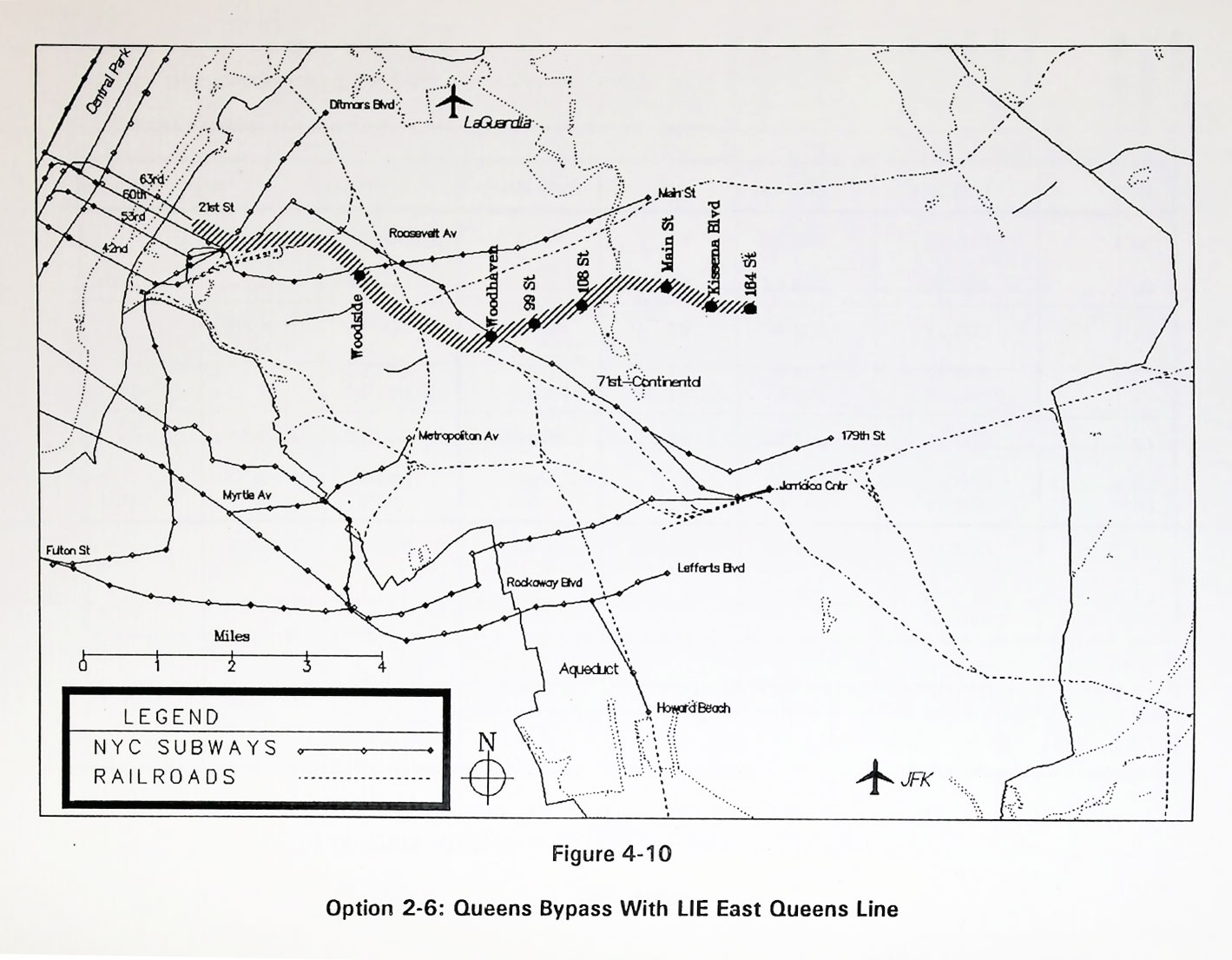
In 1991, a consultant’s report looked at different options for an extension of the 63rd St Tunnel into Queens. One of the authors, Robert Olmsted, helped compile the Program for Action when he was a planner at the MTA. The report was not done by the MTA, so the authors were free to think outside the box.
While the report contains a number of interesting proposals, the most pertinent is a plan to combine the former super-express bypass with a line along the LIE. The 2-track line would start at Northern Blvd and pass under Sunnyside Yards to a point along the LIRR Main Line near Woodside. The line would run alongside the Main Line to a point near the LIE, where it would either dive into a tunnel or rise over the highway on an aerial guideway. The report notes that this would require taking a number of buildings near the Woodside station. The line would continue along the LIE to Kissena Blvd, with provisions to continue east.
If such a line could instead be built mostly above ground, it could be built far cheaper than a new tunnel. The PANYNJ AirTrain is, so far, the only concrete aerial guideway running above a highway in the New York City area. A similar design could be utilized along the LIE instead of a tunnel.
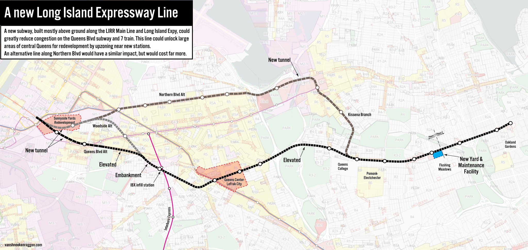
The Route
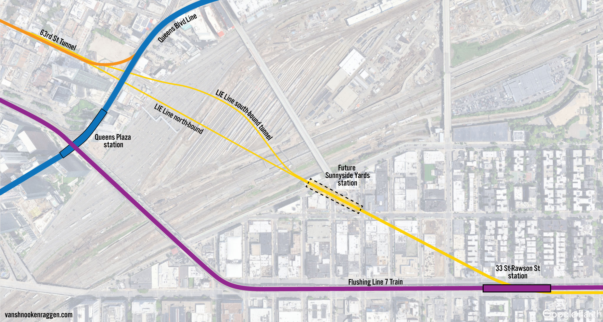
When the 63rd St Tunnel was connected to the QBL, two provisions were built to allow for a future branch under Sunnyside Yards; the north-bound bellmouth is visible from a Forest Hills-bound train, but the south-bound provision is on the lower LIRR level. Starting at these provisions, a new tunnel would be built southeast to Queens Blvd. The line could be built on a path that allows for a future station to be added near the Honeywell St bridge and Skillman Ave that would support the future air-rights development over the Sunnyside Yards. A new station would be built for transfer to the 7 train, likely at the 46th St station.
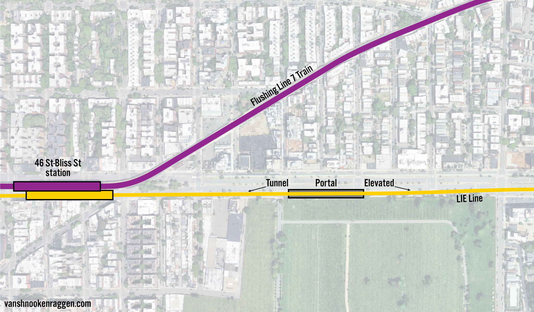
The tunnel would continue east along the southern roadway of the boulevard to 51st St. The southern frontage road of Queens Blvd along Calvary Cemetery is a glorified parking lot. A section of this roadway would be taken for a portal and ramp up to a new concrete aerial guideway running above the southern frontage road. This would continue east until it reaches the LIRR Main Line.
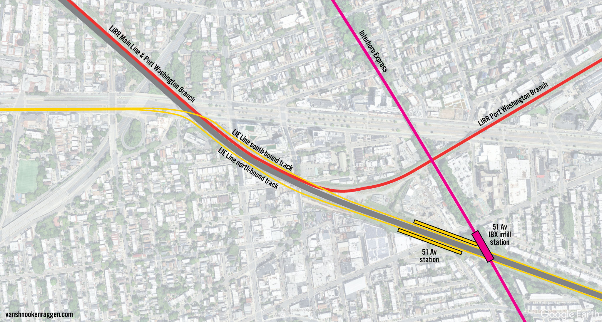
The LIRR Main Line contains space for six tracks. All six are used until the point at Whitepot Junction, where the Port Washington Branch turns off. Between here and Forest Hills are two former trackways on either side of the Main Line that were once used for the Rockaway Beach Branch. The new subway tracks would either run on both of these trackways, so that the LIRR runs between the subway tracks, or both subway tracks would run along the southern edge of the LIRR Main Line. If the second option is chosen, then a new trackway would need to be constructed, along with new bridges at crossings. Assuming the IBX is built before this line is, a station at 51st St on both the LIE Line and an infill IBX station should be constructed. This station will help relieve crowding at Roosevelt Ave.
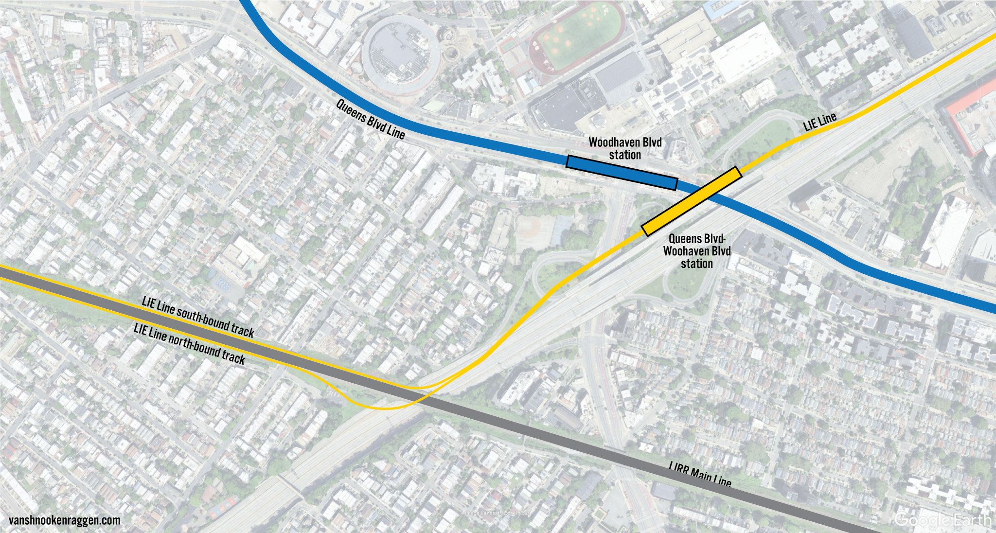
When the line reaches the LIE, the two trackways will ramp up to a new guideway above the LIE. The guideway will curve northeast to a point parallel to the expressway on the western side. A station at Queens Blvd will provide a transfer point to the Woodhaven Blvd station on the QBL. The Woodhaven Blvd station should be expanded to serve express trains. This will create an additional alternative transfer point to Roosevelt Ave, helping relieve congestion there.
From here, the LIE Line will continue along an aerial guideway built on the north side of the LIE. Stations will be built at 99th St, 108th St, Main St, Kissena Blvd, 164th St, Union Tnkp, and 188th St. After 188th St, two layup tracks will extend east for storage and future extension.
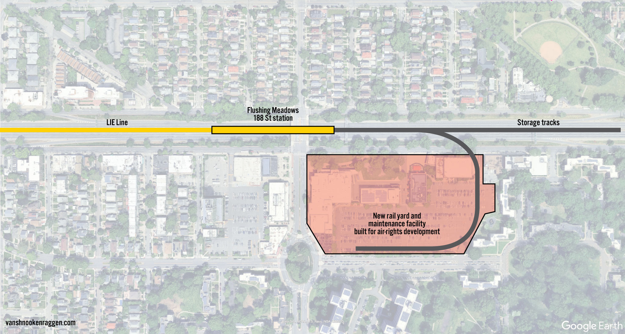
A line of this scale will require additional trains and a place to store and maintain them. The original super-express bypass plan called for a new subway yard to be built within the Sunnyside Yards. But today, space for such a yard has been taken over by the LIRR to service Grand Central Madison, so a new location is needed for a yard. There are virtually no large tracts of vacant land along the corridor, so an alternative would be to purchase the large Fresh Meadows Place shopping center at 188th St and the LIE. A new yard would be constructed below grade, allowing for air rights development over the yard. This would create dense new housing and replace the shops that had to be removed.
Service
Presently, it does not seem as if there is enough extra capacity on the Manhattan trunk subways for a new line along the LIE from the 63rd St Tunnel. But by disentangling the Broadway Line services both in Midtown and in Brooklyn, the needed capacity can be found. I’ve written in the past about deinterlining the DeKalb interlocking in Brooklyn, which would reroute Broadway and 6th Ave trains to speed up service and boost capacity. This proposal would build on that.
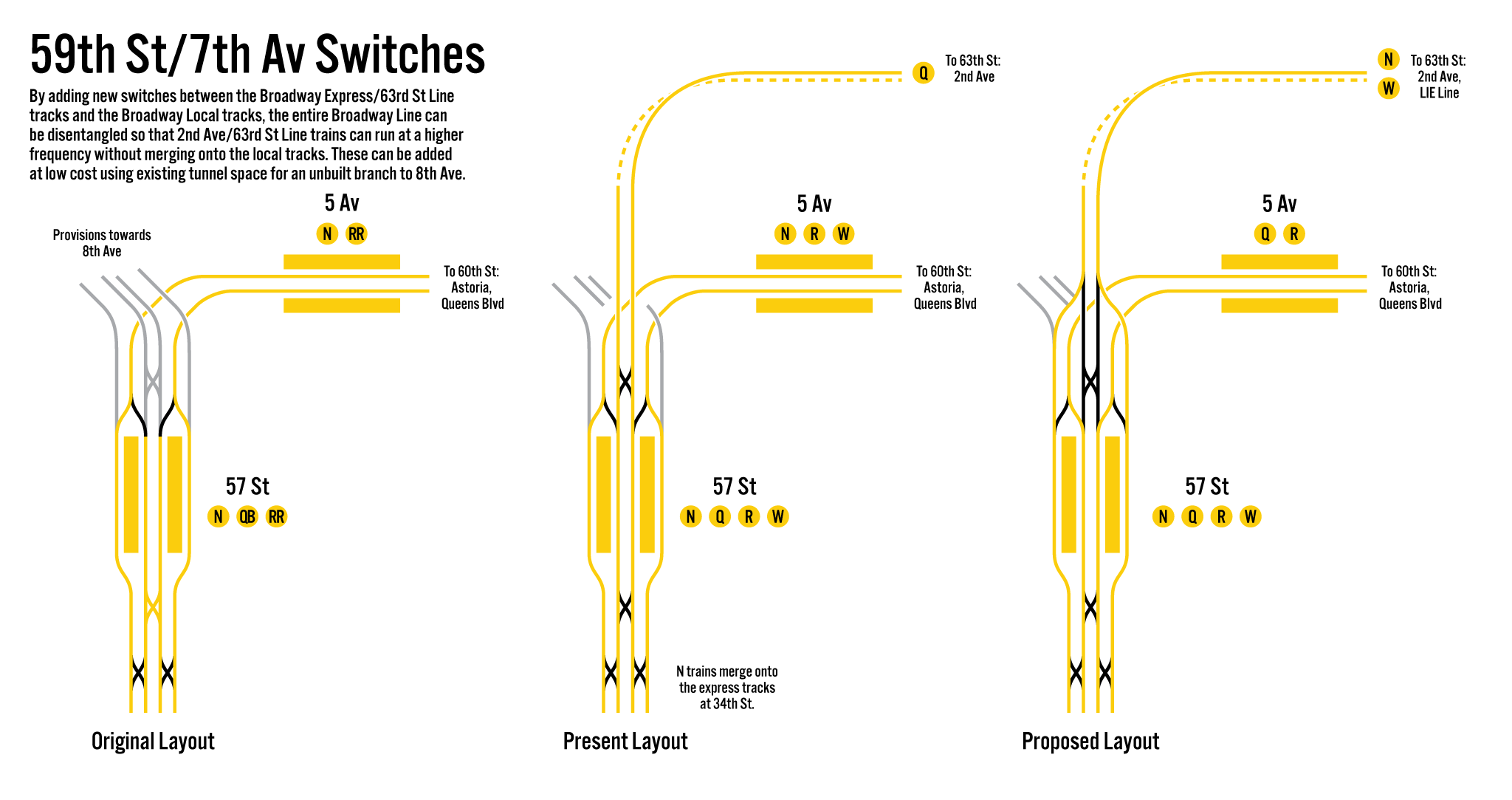
The DeKalb proposal relies on a new set of switches to be built south of the 36th St station on 4th Ave. For LIE service, a new set of switches would be built just north of the 57th St station on 7th Ave. Empty trackways exist through here, which were built when the Broadway Line was planned to be extended along Central Park West (before the IND took over building new subway lines). The express trackways were used for the 63rd St Tunnel connection, but the local trackways sit unused. By connecting the local trackways to the 63rd St tracks here, Second Ave and LIE trains can directly run through to the Broadway local tracks, while the Astoria Line and QBL trains will switch to the express tracks, eliminating the current merges.
In Queens and Manhattan, service would run as such:
- N and Q trains would swap: N trains would now run along Second Ave, Q trains would serve Astoria-Ditmars Blvd.
- W trains would shift from Astoria to the new LIE Line, using the 63rd St Tunnel.
- R trains would remain on QBL to Forest Hills.
- N/W trains would run as the Broadway local from 57th St to Whitehall, with N trains continuing into Brooklyn via the Montague St Tunnel. W trains would terminate at Whitehall but could be extended into Brooklyn should there be demand.
- Q/R trains would run as the Broadway express from 57th St to Canal St and run into Brooklyn over the Manhattan Bridge.
In Brooklyn, service would run as such:
- R trains would swap with B trains: R trains would become the Brighton Beach express to Brighton Beach. B trains, using the new switches at 36th St, would run express on 4th Ave until 36th St, then local to Bay Ridge.
- Q trains would remain as the Brighton Beach local to Coney Island–Stillwell Ave.
- N trains would swap with D trains: N trains would run local along 4th Ave until 36th St, then run over the West End Line to Coney Island-Stillwell Ave. If W trains are to be extended as well, they would terminate at Bay Parkway.
- D trains would run as the 4th Ave express to 59th St, then over the Sea Beach Line to Coney Island-Stillwell Ave.
The reason for the swaps along Broadway is to provide for the optimal service levels on each branch for peak times:
- Q trains would run at 20tph
- R trains would run at 10tph
- N trains would run at 12tph
- W trains would run at 8tph
Service on the Broadway local tracks is thought to be limited to 20tph due to the tight curves between City Hall and Cortlandt St stations. Should the upcoming CBTC signal conversion for the Broadway Line allow for more service, then this should be used for the new LIE Line. If the curves are still limiting, then additional LIE service can be run via the 6th Ave Line local, which still has extra capacity.
I am envisioning the new LIE Line to be built before the Second Ave Subway extension downtown. Once the Second Ave Line is open, the W train would shift from Broadway to Second Ave. Ultimately, the Second Ave Subway should connect to the Broad St Line in Lower Manhattan so that Second Ave service, the T train, can extend from Manhattan to Brooklyn. The way that the new Broadway Line service is set up, T trains will reverse-branch with N trains along upper Second Ave and then through the Montague St Tunnel and along the West End Line. Second Ave W trains would use a new terminal built at the Chatham Sq station. Shifting the W to Second Ave will allow for more than double the service to be run along the LIE Line.
Cost and Benefits
Clocking in at almost 9 miles long, the entire LIE Line as proposed will be one of the largest expansion projects on the books. The IBX will be 14 miles long but will be built entirely along an existing ROW. The LIE Line will only be cost-effective if it’s built above ground, along the LIRR Main Line, and along aerial guideways. A 1.5-mile tunnel will connect the 63rd St Tunnel at Northern Blvd to Queens Blvd, with a portal at 52nd St. With 10 initial stations (a Sunnyside Yards station should only be built as part of any air rights development over the yards), the total cost will be in the ballpark of $9.75 billion (2025). This number is derived from looking at recent examples of transit projects in London, which faced similar cost overruns as NYC projects.
The overall benefits of the line are twofold: reduce crowding on existing subways (QBL and 7 Train) while creating upzoning opportunities along the line. The recently passed City of Yes housing policy allows for upzoning a half mile area around existing and new subway stations. For the LIE Line, this means that 8 of the 10 new stations would create upzoning potential. Most of these stations will be located in areas that could support larger developments in their own right, as opposed to areas that are now primarily single-family homes.
The 51st St station, for instance, straddles the line between a low-density residential neighborhood (Maspeth) with a commercial and high-density corridor along Queens Blvd. With the decline of large retail centers due to online retailers, the malls centered around the LIE in Rego Park are prime locations for large-scale redevelopment. Further out, the massive superblocks that contain Queens College, Pomonk/Elechester housing, and Fresh Meadows housing would also be prime areas for denser infill development.
Conclusion
One of the criticisms of Congestion Pricing, which charges drivers to enter Manhattan below 60th St, is that it’s all stick and no carrot. As transit-rich as New York City is, there are still many areas where fast, convenient transit is not available. The MTA promised that Congestion Pricing money would go to fixing the existing network so that it’s more reliable, and the IBX will serve a few areas of Brooklyn and Queens that today do not have good transit. But the vast majority of Queens east of the Van Wyck Expy will see no sizable relief. The LIE Line will serve only a section of Queens. But this section represents the highest return on investment for a new line.
The LIE Line is an ambitious undertaking. But learning how to effectively utilize aerial guideways above highways and streets is something the MTA needs to take on. It’s the only affordable way to truly expand the subway network in New York City that will make a meaningful dent in eliminating transit deserts. There are only a few existing ROWs left; the IBX is taking up one of the largest, and the QueensLink aims to reactivate the other. New tunnels are expensive. Concentrating new development in already expensive areas is a terrible way to build affordable housing without massive subsidies. Opening up areas further out for growth, with lower land costs, will make a massive dent in our affordable housing needs.
I want to give a special thanks to Alan Olmsted, son of MTA planner Robert Olmsted, who was indispensable in putting this post together. Alan shared his father’s vast library with me and scanned the reports that were posted here.
Funny enough I had just been working on a proposal that coincidentally followed the 1963/Northern alignment almost exactly. My question is wouldn’t it be more cost-effective to build the eastern portion of the line from Main St as an extension of the 7 along Kissena, and then eventually connect it with SAS P3 via Northern at a later date? I feel like splitting service between SAS and the LIE is more of a compromise compared to extending the 7 and improving express service on the Port Washington Branch
Funny enough, this was looked at back in 1968 while putting together the Program for Action.
Page 18: https://archive.org/details/standardsforrapidtransitexpansion/Standards%20for%20Rapid%20Transit%20Expansion%20-/page/n21/mode/2up
“Rejected Alternative: It has been previously proposed by various groups that the new northeast Queens extension be built via Northern Boulevard through Flushing and along Kissena Boulevard. This route, however, would be unduly circuitous and would invlove unneccessarily long travel time between outer Queens and Manhattan. The line would require about seven miles of costly new subway construction through central Queens area west of Flushing. This area will not require additional local service since the northeast Queens route will divert enough riders to free up additional capacity on the parallel Flushing IRT line. The proposed Northeast extension along the Long Island Expressway, plus additional in-City service on the Port Washington Branch of the LIRR will provide better service to northeast Queens for considerably less money.”
I wonder if wouldn’t it be more cost-effective to convert the LIRR Port Washington Branch (which sees 5TPH during rush hour) to subway and then build a branch to the LIE Line east of Mets-Willets Point along Meridian Road. Infill stations could be added at Broadway (near Elmhurst Av Station on the QBL), Junction Blvd & 108th St would relieve congestion on the (7).
(W) to Port Washington
(M) to 188th St – Fresh Meadows
(R) to Rockaway Park
(G) to Forest Hills
(A branch of the SAS could replace the (W) at a later date, with the spare capacity on the BMT Broadway Line added to the (N))
Converting the LIRR to subways would screw over riders east of the city line. Converting that to a shuttle is a non-starter. You’d also miss the benefits to the Queens Blvd Line near Woodhaven Blvd.
The evolution of these ideas has been fascinating to see over the decades. These ideas for an LIE line and the rearrangement of service on the Broadway line look like good, practical ways to approach these issues of improved service in Queens. I have wondered if there was a reasonable way to add service by coming up with a way to utilize the full capacity of the 63rd St. tunnel. As others have stated, it would also be nice to extend the G train again. The way that intrigued me going back was the one in this article from 2015: https://www.vanshnookenraggen.com/_index/2015/09/the-futurenycsubway-queens-flushing-trunk-line-revisited/ It showed a map of a possible Northern Blvd. subway in a section titled, “NORTHERN BOULEVARD TRUNK LINE AND THE 2ND AVE SUBWAY.” It is interesting that it said, “A subway along the LIE is the most obvious answer but with the congestion along Queens Blvd a branch along the LIE would do more harm than good.” We are now 10 years later and I think the points you make now are good ones.
I love keeping my old ideas around to see how my thoughts have evolved. Some ideas stick around. Some make me laugh.
Before reading this post, I favored just extending the R train off of QBL at Woodhaven Blvd as the LIE line. But now I see that such an extension would likely preclude Queenslink, because the M would be needed for service to 67th Ave. By keeping the 63rd/LIE line separate from QBL it helps keep the QBL services from being stretched too thin. And the rearranging of the Broadway services (N/W local via 63rd; Q/R express via 60th), it facilitates making the M a Mon-Sun service to/from the Rockaways and then the R can be the supplemental Mon-Fri QBL local and the G can replace it on the weekends (I feel like the R as the Brighton express on Mon-Fri is likely sufficient). And there would be no issues with the Astoria Line not being attached to a yard if the Q goes there.
This guy gets it.
Van, do you plan to put out a new Future NYC Subway map that includes some of your recent proposals? I’d love to see one with this LIE extension, Queenslink/G extension, 7 train extensions, IBX extensions to the airport/Harlem, SAS phases 2, 3 and 4, Northern Blvd line, Utica, and any other adds or fixes you think are at least somewhat realistic within the next 40 years. Maybe even include some of the presumed HBLR extensions as well?
I don’t have any plans to do so, but that doesn’t mean I won’t.
Wonderful dive into the mid-20th century planning efforts around the MTA’s “Program for Action”, among other efforts as well. Really thorough!
I always felt like the various proposals for the LIE rapid transit line reminded me of some of the similar efforts in Philadelphia to extend the Broad Street Subway as part of a “Northeast Expressway” along (if not always proposed exactly along) the Roosevelt Boulevard corridor.
Fascinating stuff, van – again, nicely done!
It is so serendipitous to see someone revising their thoughts on this line as I’ve been playing with my own crayons around that area for quite some time now. It’s even more amazing too that you came to a similar conclusion on how to handle a service pattern along the LIE that I did but ultimately relented from because I didn’t think the turn northeast off the LIRR mainline was a feasible thing (not because I particularly believed it wasn’t but because I’d never seen anyone else address it for me to understand what was possible).
Now I’m here revising my own concepts because I always loved that idea. Thanks for the great writeup to point back to!
One issue missing from the mostly historical discussions is freight operations. Yes the LIRR runs very little fright now but given the presence of many more customers along the LIE it would be an important point of discussion. However given the intent of concrete elevated tracks I’m not sure of the weight of a freight train could be supported.