
Those who follows me on Twitter (where I am far more active than on this blog, unfortunately) might be aware that I have been talking about a project called QueensLink for some time. Since 2017 I’ve been working with QueensRail, a 501c3 not-for-profit which has advocated restoring service on the abandoned Rockaway Beach Branch in central Queens. While our website has been live since 2019, I hadn’t mentioned the project on this blog until now.
The QueensLink is a new take on an old idea. Out in central Queens lies the remnants of the abandoned LIRR Rockaway Beach Branch. The southern section of the line was added to the subway network in 1956 as an extension of the A train but the northern section, 3.5 miles of above ground tracks, was left abandoned as there was no viable way to link it up with the subway. Many studies over the years have looked at ways to reactivate the line, most notably as an express connection to JFK Airport.
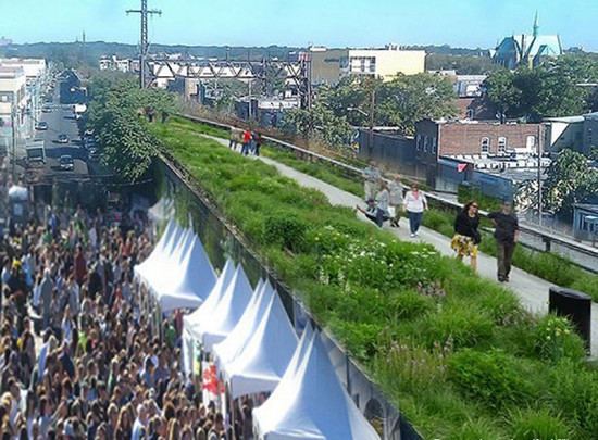
In 2015 a park advocacy group came up with their own plan for the line: The Queensway. The Queensway was modeled on the High Line in Manhattan. They assumed that the line could never be restored to passenger service and that it should be rebuilt as a park. Locals were cool to the idea and even now funding for the idea has remained elusive. The biggest problem with the Queensway proposal is that it assumes that rail is impossible. QueensRail reached out to the Friends of the Queensway early on to find a way to work together but they were very much opposed. The Queensway park isn’t a neutral actor but is very much designed to block any future use of the line for transit.
QueensRail, on the other hand, has been advocating for much longer to restore passenger rail service. The problem was that with a park alternative there seemed to be two competing ideas. At the time, in 2016, both sides seemed to think that only one option was viable. While reading about the conflict I realized that many transit projects throughout the world integrate parks and transit; Why should this be any different? I wrote a post on the idea that the solution seemed to be that both rail and parks could co-exist. A few months later Rick Horan, the president of QueensRail, reached out to me to see if I would be interested in developing the idea further.

After looking over what QueensRail had already produced and taking a tour of the line I realized that the project was more realistic than I had even imagined. The right-of-way was quite large in parts and with creative use of the embankment we could incorporate a variety of park uses. I felt that in order for us to restart the conversation that we needed to rebrand. “Rail” was decisive in some parts as people could look at the elevated J train and imagine something like that in their backyards. We needed a name which changed the conversation from something potentially bad to something more ambiguously good.
The name QueensLink was chosen because the value of restoring rail isn’t just for better transportation but the fact that this line could literally link together the city. Queens is a divided borough; all rail lines lead to Manhattan. If one wishes to get around Queens without a car it can be a very long and arduous journey on multiple bus routes. The Rockaway Beach Branch literally cuts a line north-south through the heart of the borough and connects each east-west subway line in the process. The addition of local parks along the route further helps to cement neighborhood cohesion. Thus, we can link Queens together.
The Concept
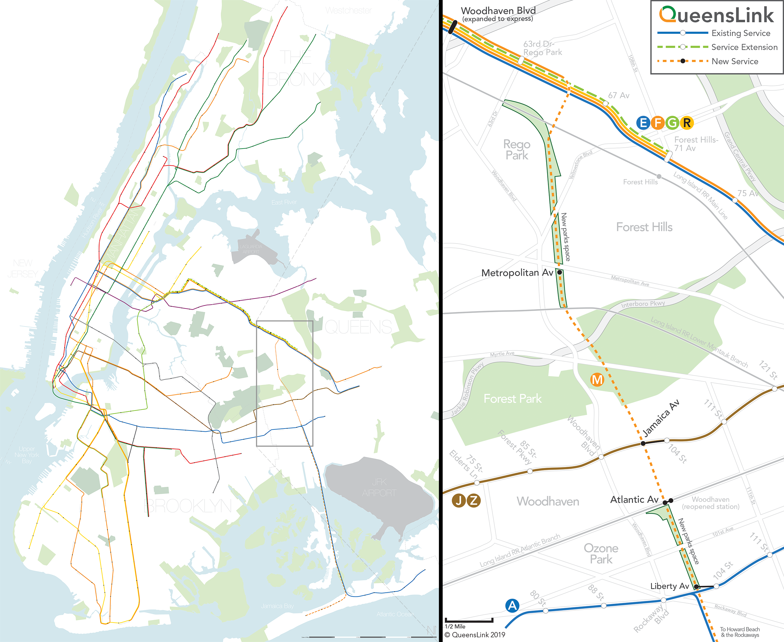
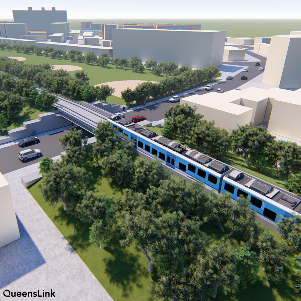
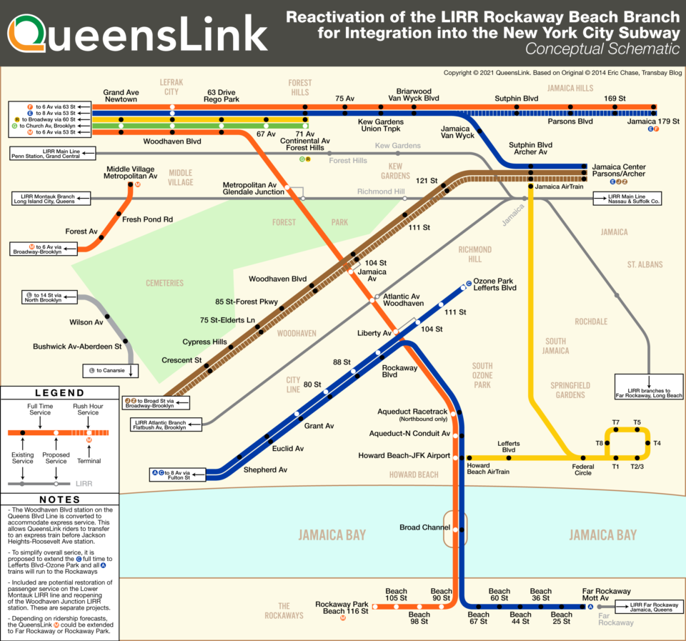
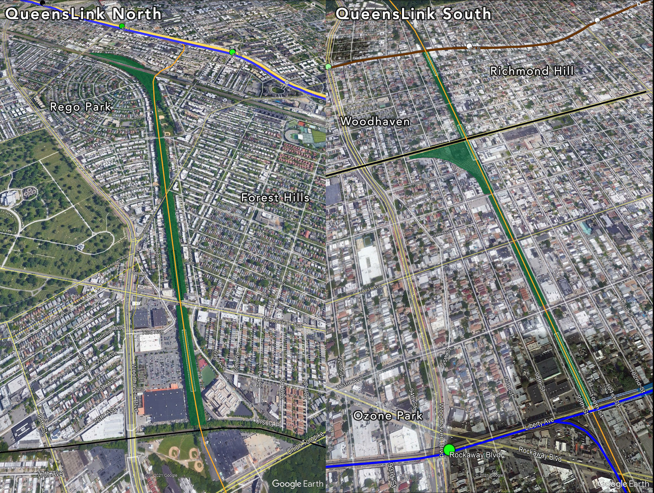
The QueensLink is a proposal to build a new transit line and park system along the abandoned section of the former LIRR Rockaway Beach Branch line which runs north-south from Rego Park to Ozone Park in Queens. The 3.5 mile-long line parallels Woodhaven Blvd and was built along an elevated, earthen embankment. By connecting the line to the Queens Blvd subway line and extending it south to connect to the A train at Howard Beach we can create the first north-south transit connection in Queens.
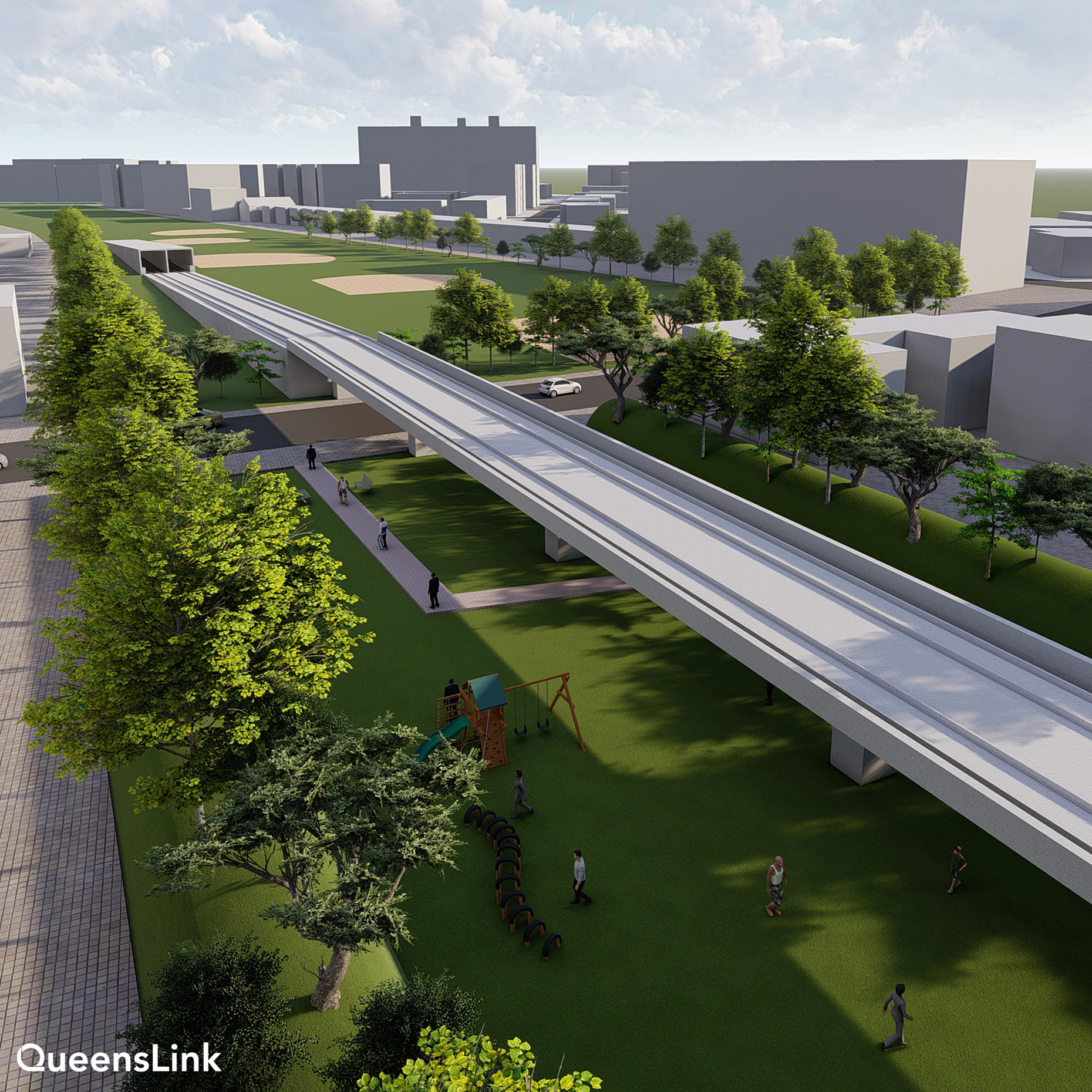
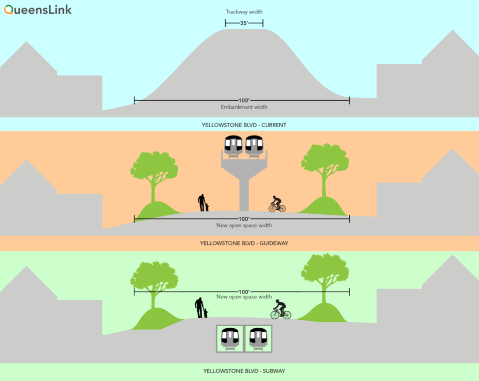
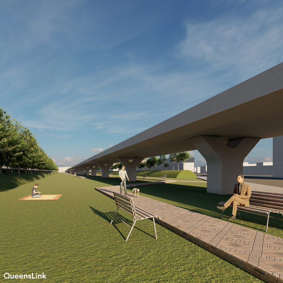
In the northern section, much of the right-of-way is very wide but currently overgrown. QueensLink proposes to reimagine this space along the tracks for parks or a bike/pedestrian path. This can be done in a variety of ways (each with different price tags). The first is to simply activate the existing land around the embankment with walking or bike paths. The second would be to remove the embankment and replace it with an elevated viaduct, similar to the JFK AirTrain, and use the space below the viaduct for park use. The third would be to remove the embankment and replace it with a shallow tunnel (this would be much cheaper to build than using a tunnel boring machine like under 2nd Ave). The space above the tunnel would then be used for parks.
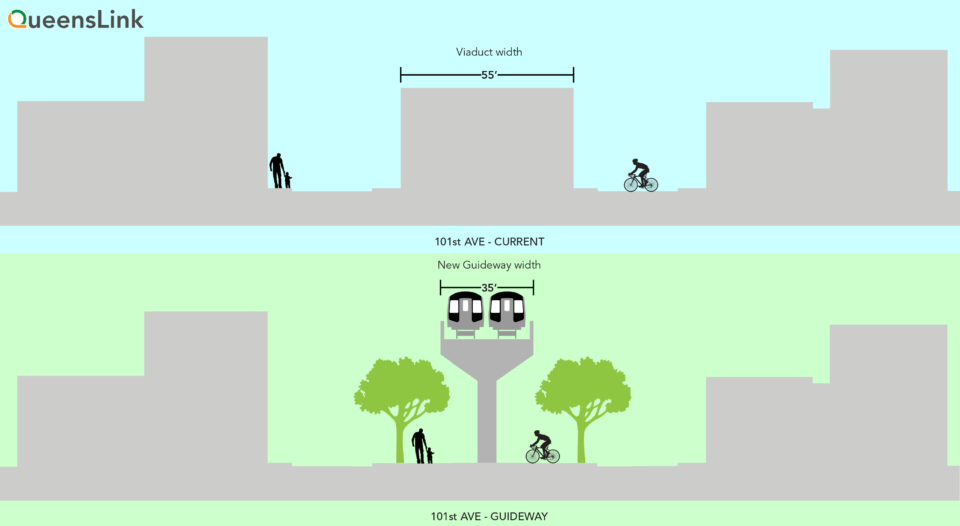
In the south, where the line runs on a wide viaduct, QueensLink proposes to utilize the space below the tracks (currently home to garages and auto body shops) for new parks or community spaces. Similar to the northern section, the existing viaduct could be saved with the spaces used for community purposes. Alternatively, the existing viaduct could be replaced with a smaller guideway, opening up the land below for park use.
Service on the QueensLink would be provided by an extension of the M train from the Queens Blvd subway. (The alternative is a connection to the LIRR Main Line.) The M train is preferred because it would provide a much higher frequency of service and provide connections to the other subway lines in Queens. The M train would reduce travel time from Howard Beach to 42nd St from over an hour (today) to 45 min. The LIRR alternative would have a travel time of 25 min but have less frequent service and offer fewer connections to the region’s transit network.
Previous studies made about restoring service on the Rockaway Beach Branch looked at a variety of different modes. In addition to a subway line and LIRR service, other ideas were to run light rail on the line, bus rapid transit, and even the AirTrain itself. The official MTA report discarded the light rail, bus rapid transit and AirTrain alternatives as they would not provide a one-seat-ride to midtown Manhattan (or in the case of the AirTrain, it was a different agency.)
A hybrid plan of running either LIRR service over the A train section to Rockaway OR subway service along the LIRR Main Line has been brought up as technically feasible, but mixing these services would create cross agency complications and limit overall capacity. The subway alternative was chosen because it was the most simple and provides the highest frequency of service for a one-seat-ride through Queens and into Manhattan.
By extending the M train the QueensLink would connect each of the major east-west subways together. Riders could have a simple one or two seat-ride to anywhere the subway goes to. It may also be possible to connect to the LIRR via restored passenger service on the LIRR Lower Montauk Line or a reopened Woodhaven station on the LIRR Atlantic Branch.
Extending the M train would also allow for greater capacity on the Queens Blvd subway line. Local trains are limited by the poor terminal design at Forest Hills-71 Ave. By rerouting the 8-10 trains per hour to Rockaway these slots are now available for the return of the G train. With the new CBTC signal system the local tracks would be able to run all existing G, M and R trains.
We are also proposing expanding the Woodhaven Blvd station on the Queens Blvd line from local to express. This would allow Rockaway riders to transfer, speeding up their trips even more, and reduce delays at Roosevelt Ave station further down. Roosevelt Ave sees delays due to riders switching from local to express. But if these riders could get the express at Woodhaven Blvd instead then trains could load more quickly at Roosevelt, improving service on express trains.
This connection would revolutionize how people can get around Queens and even the rest of New York City. The current hub-and-spoke design of the NYC subway is great if you are commuting into Manhattan. But in a post-Covid world where people have more options of where they can work this design no longer works. An inter-connected network allows riders multiple ways of getting around.
The QueensLink would allow riders who are going to midtown to avoid first having to travel through downtown Brooklyn and lower Manhattan. This will free up space on trains there, most notably the A and C trains. Travelers needing to reach JFK Airport will now have a quicker ride to Howard Beach, freeing up space on the packed E trains to Jamaica.
This new service will also dramatically reduce wait times for riders of the Rockaway Lines. Faster, more reliable service will encourage more people to ride the subway rather than drive and the new connections will allow for more areas of the city to be reached without a car. Reducing car dependency will be key for a more sustainable future. Fewer cars mean less air pollution and less runoff that poisons Jamaica Bay. Fewer cars on Woodhaven Blvd and Queens Blvd makes these roads safer for all users.
Rails and Trails
QueensLink was created out of a need to find the best possible use for such an important assent like the Rockaway Beach Branch. Previously there were two competing visions for the land: restored rail service or conversion to a High Line-style park. Past rail proposals often only focused on express service to JFK Airport, bypassing local communities which would have benefited from the service. The park proposal, dubbed Queensway, was a lavishly designed fantasy which would have completely taken over the entire right-of-way, leaving no possible way that trains could ever run on the line again.
While New Yorkers often celebrate how diverse this city is, they are often guilty of being myopic and assuming that if we can’t do something here then it can’t be done. Everywhere else around the nation and globe new rail lines are built with park incorporated. The same can easily be done here.
The right-of-way on the northern section, from 63rd Dr to the Lower Montauk rail line, varies in width but is often over 100’ wide. The southern section is much narrower, but there are still options. Should the embankment and viaduct be rebuilt as a modern guideway then the space below could be used as a bike/pedestrian path. In Ozone Park, the viaduct takes up the entire block between 99th and 100th streets. This, too, can be opened up with a new viaduct or have the existing structure be converted into a market or community space.
The former turnout at Atlantic Ave, where LIRR trains once switched to go to Brooklyn, could be repurposed as park land as well. Currently, it is home to a parking lot for the Logan Bus company. The bus company has a month-to-month lease with the city which will have to work with them to find a replacement location.
The central section runs through Forest Park and the land has been converted to NYC Parks property. This means that if the land were to be converted back to transit use these 9 or so acres would need to be replaced. Luckily, the potential park space that could be created by QueensLink is about 33 acres.
The MTA Study
In 2013 the MTA had been tasked with creating a study looking at the feasibility of restoring service on the Rockaway Beach Branch. Then Assemblyman Phil Goldfeder secured funding for the study. The MTA kept pushing back the release of their feasibility study until 2019 when it was discovered that the report had been finished a year prior but had not been released. With some cajoling the MTA dropped the study on a Friday afternoon in October 2019. The front page of the study showed a date of September 2018. They had indeed tried to bury the study.
The study, overall, was quite positive. It looked at two possibilities: restoring LIRR service from the Main Line (at Whitepot Junction) to Howard Beach or connecting it to the subway at 63rd Dr and extending service south to the Rockaways (there are two branches of the subway in the Rockaways, one is served full time by the A train and the other is served full time by a shuttle to Broad Channel with a few A trains at rush hour. The report did not discuss where this new subway service would run.) The report even indicated that some of the right-of-way could be reused for park space.
But then came the kicker: The Rockaway Beach Branch rail line is built on an elevated embankment which, except for a couple bridges, is completely intact. The report found that the LIRR option would cost $6.7 billion and the subway option $8.1 billion. Even in a city that is home to the three most expensive subway project of all time this was an outrageous price tag.
Any media that picked up the story never got past the sticker shock. We had a feeling this was done on purpose. The MTA dragged their feet on starting the report and then tried to hide it. The cost estimate was suspect. We began to sort through the budget which was included in the report and started to find large amounts which made no sense. Through the office of Assemblywoman Stacey Pheffer-Amato of Rockaway we asked the MTA to comment, and they politely declined (or, rather, they said that was the cost because they said so.) We tried to get more information from them through a Freedom of Information Act request. Just this May, 2021, after a number of attempts and appeals, did we finally get the document we requested, 99% redacted. All it showed was that their consulting firm, SYSTRA, was paid over $800,000 for their work.
We decided to fight fire with fire and develop our own counter-report that could prove these numbers were wrong. By utilizing a series of discretionary grants from city council members we were able to hire a consulting firm, Transportation Economics and Management, Inc (TEMS) headed by Alexander Metcalf, to review the MTA’s work.
Before we delve into the report, a note. This is NOT a full environmental impact statement which would look at possible alternatives, estimate ridership, and develop funding strategies. A report of that scope will cost about $250,000. QueensRail had a fraction of that. What we needed at this point were two things: a professional reappraisal of the official MTA cost estimate and an idea of what kind of economic impact such an investment would have on Queens. No politician would touch this project if they seriously though it would cost $8.1 billion. If it were to cost much less than we’d have to figure out a way to pay for it which is where the potential economic development comes in. We intend to use this report to begin fundraising efforts in support of the full study.
QueensLink Report
The full report can be found here.
With our report we needed to show two things: first, the the official MTA cost estimate is wrong (and how it’s wrong) and, second, that such an investment would lead to economic growth that would justify the costs.
The official cost estimate from the MTA report is that a subway extension would cost $8.1 billion. We found that this estimate can be broken into two sections: construction costs and “soft” costs which comprise professional services (payments to contractors and whatnot), contingency costs (for the inevitable cost overruns) and Year of Expenditure Escalation (which factors inflation into the cost).
By breaking down these costs we found that the construction costs would come in at about $1.8 billion and the soft costs would, amazingly, make up $6.3 billion. TEMS looked at the numbers and found that SYSTRA, the firm contracted by the MTA to produce their Rockaway Branch study, used formulas that are out of line with industry standards. They used costs based not on “present” dollars but on 2030 dollars with inflation already factored in (as opposed to just what inflation would cost) and they added completely unrealistic contingency costs for no explainable reason. They also gave themselves an inflated professional services fee as a cherry on top.
All of these costs are broken down in the report but are also available as part of the MTA’s Rockaway Beach Branch Study, Appendix H. [PDF]

Using formulas recommended by the FTA itself then we find that the soft costs come down substantially. The actual construction costs seem to be in line with other US transit projects. These costs will inevitable change as the project is developed and actual designs are finalized (especially once the park space is developed.) But with normal soft costs we find that the project would come in between $3.4 and $3.7 billion. This cost difference is based on whether or not the existing bridges need to be replaced. The MTA study suggests they do, but an independent engineer for the Queensway suggested otherwise.
The report then outlines the benefits of such an investment. By comparing the project of similar builds, most notably the Purple Line outside of Washington, D.C. (which is still under construction) and the Hudson-Bergen Light Rail in New Jersey, that over the course of the project’s lifetime it could:
- produce up to 150,000 new jobs
- up to $75 billion increased property values along the line
- bring in up to $13 billion in personal income
Additionally, the time saved from longer commutes would add up to 125 hours a year, or 5 full days. Other benefits include reduced auto emissions and reduced accident rates from the number of cars taken off the road.
Funding
The argument you always hear is that there is never any money for a project. My counter to this is that there is always money for the things we truly want. I would also argue that we are quickly approaching a point at which all the necessary factors are coming together for this project to succeed.
In Washington, the Biden administration is hammering out a large new infrastructure bill which aims at supporting transit like never before. Transportation secretary Pete Buttigieg is pro rail and pro transit and has already set in motion the long stalled Gateway project to build new tunnels under the Hudson River into Penn Station. With a pro-transit administration we have a better chance at getting this project funded than ever before.
Queens itself is changing. For generations the middle class neighborhoods of the boroughs fought against restoration of the Rockaway Beach Branch. But a new, more progressive generation of leaders are stepping up. These leaders want a more sustainable, safer, and healthier city. Bike lanes in Queens are arguably better than ones in Brooklyn. In terms of transit, Queens needs more trains and bus lanes than any other borough. We are finally hearing voices speaking up for this transformation.
The QueensLink still has a long way to go. We are now working with the Queens Borough President’s office to bring together stakeholders along the line to begin working together to find a way to build this project. New transit and new parks should be the goal of all New Yorkers rather than two sides pit against one another to continue the status quo.
How to get involved
If you’d like to know more about the QueensLink check out our website, Instagram, and Twitter. If you’d like to receive updates on the project you can email me and I will add you to our mailing list.
Over this next year we plan on building coalitions with like-minded groups within Queens who could also benefit from better transportation. If you are involved with such a group please email me and let’s open a dialogue.
Even $3.7 billion is a lot. The infrastructure is all still there, so shouldn’t it be really cheap to reuse it as a LIRR branch (which would also be much faster than subway to Manhattan)? The ROW has 4 tracks, so how about 2 tracks for a rail line and 2 tracks’ space (~7 meters) for a landscaped bike/walking path? Is there any reason this should cost more than a few hundred million dollars?
yes, widespread government corruption that we can seemingly never rid ourselves of
The new cost estimate does seem high but this is not a full engineering plan where everything is priced out. It’s an estimate. The ROW is “intact” but that doesn’t mean you can just go up there and start running trains. The ROW needs to be cleared and stabilized, new tracks, signals, electronics, etc all installed. That adds up. The costs are in line with similar projects. Even if this was a LIRR branch (which I’ve explained why this isn’t the ideal choice) it would still require all this work.
The ROW is only 4 tracks wide south of Atlantic Ave but the ROW north of Forest Park is 100′ wide.
Eric,
Sure, any number in the billions is a lot, but you need to weight this with the return on investment. In the case of QueensLink, this is anticipated to be between $100 and $150 billion over the life of the project.
While the LIRR connection will get you Manhattan a little faster, the subway alignment opens up all sorts of different connection possibilities in Queens and will serve at least 3x number of daily passengers according to the MTA. It will also get you to midtown at least 15 minutes faster than is possible today.
LIRR would have a transfer to the 7 and some local bus lines, just like a subway. It would lack a transfer to the Queens Ave subway, but then it would have a transfer to the LIRR. So overall it seems like a wash in terms of access, but LIRR would be much cheaper, a big deal given the MTA’s budget constraints.
If LIRR is projected for lower ridership, that’s probably because it would run at low frequency with high fares and not allow transfers to subway/bus. But these are choices, there is no reason LIRR has to run this way (here or elsewhere).
Thank you for the in-depth, and no fucks given review of a project that really shouldn’t cost more than the second avenue subway when its abandoned piece of property within middle-class neighborhoods.
This is a response to “Kevin”This costing includes a build out of an express station an a flying junction switch out from the IND line. It also involves station modifications for transfers to the Atlantic Ave LIRR, and a removal of the embankment to allow park land.
It also addresses the potential property tax upside for the City.
I think this has been a more than admirable effort by a grassroots organization to get Washington and the MTA to look at this project.
I love the idea but I don’t think the M train is the best option to send to rockway branch since it only operates during Weekdays. I believe the G train would be a better option. That or renaming the Rockway shuttle the H train and extending it there during Weekends and late Nights. This is one way how the 2nd Ave line could be connected to queens blvd
The R to/from Whitehall (with some trains relaying at City Hall lower) would be a better choice than either the G or M. The W can be upgraded to 24/7 operation and replace the R in Brooklyn. The M almost always gets cut from QB whenever service takes a dive on that line and that would leave riders high and dry if the M is extended onto the branch.
you mentioned that you used formulas recommended by the FTA itself. i’m interested in seeing these formulas for myself; where are these available?
Check out the Appendix A at the back of the report.
Now buried in one of the reports, and I am sure that Vanshnookenragen himself drew the map himself, of having “M” trains solely going to Rockaway Park, “A” trains to Far Rockaway and “C” trains to Lefferts Boulevard. A fantasy perhaps?!?
Now really, does anyone really believe that longtime Richmond Hill riders to and from Lefferts Boulevard want to see their one-seat Manhattan-oriented express ride (the “A”) traded for a local service (the “C”)? They will howl loudly and rightly so. Keep in mind that Lefferts is a heavily used subway-bus feeder connection, serving those riders that come on and off the #Q10 and #Q112 buses from areas not served by subway or el.
I have said and posted in the past that the Lefferts terminal sees more weekday passenger traffic than the two Rockaway terminals. Also, there is that chance that Rockaway train traffic, and it has happened in the past, that conditions can be comprised, particularly when one of the Jamaica Bay bridges is not functioning (i.e. closed due to marine traffic), which happened one recent weekend when service on the line was halted almost for two hours.
Now, if the study wanted to make the “M” a very, very long round about route between Rockaway Park and Metropolitan Avenue with 24/7 service, they would have to consider the cost of perhaps extending the platforms even on the Myrtle Avenue and Broadway-Brooklyn elevated sections to handle ten car trains, from eight. Of course, additional rail cars will have to be purchased though, but are operating crews would really want to work on such a very extremely long route to travel about from terminal point to terminal point?
It also points of having the “G” coming back to/from Forest Hills. That would be too much of a strain along the QBL local tracks, with three different services (“G”, “M”, “R”) clogging up and down the line. Imagine if there is trouble on the express tracks if the “E” and “F” has to be routed there on the local tracks, and vice versa when the locals go on the express tracks.
Then there is eminent domain that would have to be used on taking over certain properties that have built and paved over parts of the former right-of-way, plus the tunneling under the buildings located south of Queens Boulevard. Of course, then there is the rebuilding of the right-of-way and the construction of the replacement bridges.
Maybe the study does show the costs as lower in their estimate, but that sounds me like at a low-ball figure that they are projecting though.
I’m not in favor of running the C local to Lefferts too. I’ve got my reasons. But it’s a discussion for a different time.
That $8.1 billion figure from the MTA’s study was pretty much the MTA’s way of telling everyone in favor of restoring train service to go take a flying leap into Jamaica Bay. That’s obvious. No way it can possibly cost $8 billion to put train service back onto an existing r-o-w, even one that’s sat unused for nearly 60 years. Unless maybe the rails and the station buildings are going to be made out of gold. And with the MTA’s propensity to cut corners, that ain’t gonna happen!
I will agree that the M is not the right choice for the service. The M already has a lot of merges, including a flat junction at Myrtle-Broadway. It is almost always the first service booted of the Queens Blvd Line when service takes a nosedive on that line, usually getting rerouted to Chambers St. The R would be a better option, if – and only if – it terminates in Manhattan (Whitehall or Canal). If done in tandem with eliminating the N switching from express to local at 34th St, it would work. The W would become a 24/7 service and replace the R in Brooklyn.
If you build the 2nd Avenue line with connections to the Fulton street it could be possible: First connect 2nd Ave phase 4 or connect the 2nd Ave to Nassau broad st line to the montague st tunnel than relocate the transit museum somewhere else with the 2nd ave line build with a connection to the Fulton st line have the (T) train would than take over local service for the (C) train and run to Euclid Avenue and this frees up the(C) train to be moved to the express tracks along side the (A) train this which would also(C) trains to be extended to Lefferts blvd without creating YET ANOTHER interlocking issue that way all (A) train would can be diverted to the Rockways.
NYC residents (especially Queens residents) can greatly benefit from a more efficient way to get to the Rockaways by public transit. Using an existing track line that includes park space is both inspirational and realistic.
The article mentions $8bn was a prohibitively large (if not factual) cost.. sadly the MTA is already fighting a very real $8bn deficit.
Love the collaborative urban planning, wish our budget had the same enthusiasm.
https://www.masstransitmag.com/management/article/21210963/new-york-mta-backs-off-service-reductions-and-layoffs-but-still-faces-8-billion-deficit-through-2024
Wouldn’t woodhaven blvd becoming an express station slow down service and increase congestion. The dwell times at Woodhaven Blvd will hold up express trains and reduce capacity even further. Queens blvd is so overcrowded that people leaving Roosevelt Avenue trains get filled up by customers anyways at queens plaza and forest hills.
It would reduce congestion because everyone wouldn’t be scrambling to pack on to express trains at Roosevelt. It would spread the load. And any time lost with the extra express stop would be made up by reducing delays at Roosevelt.
Well ok. I mean you’re right about that seeing that woodhaven blvd has a higher custom count than queens blvd and Roosevelt ave is very over, so woodhaven blvd becoming express should reduce pressure over there. But how would woodhaven blvd be expanded. Oh and unrelated to this topic but is there a new 2nd Ave plan you came up with just curious. Thanks for answering my question.
Woodhaven Blvd station was built with provisions to be expanded into an express station. The local tracks would be rerouted around the existing platforms, which themselves would be widened. The express tracks would probably be shifted to where the current local tracks are. However, this is just the sketch in my head.
I have no plans to release anything related to 2nd Ave Subway anytime soon.
This is a well written proposal things I would recommend.
Maybe sent the R train down there instead since the M train operates during Weekdays only and is 8 cars. And give the G train new tech trains for queens blvd.
Other than that great plan. I’m surprised the MTA haven’t hired you yet
I don’t see 8 car M trains as that much of an issue. Ridership would be good but not overwhelming to the point that you’d need extra cars. However, for summer time weekends I could see them running special longer trains which could terminate at 2 Av.
Obviously I’m all for extending the Eastern Division platforms to 10 cars but that isn’t necessary for QL to operate well.
The M now is relatively short and has its own yard at Fresh Pond. Running the R would be longer and it would lose its yard access at Jamaica Yard.
It doesn’t benefit Queens to Bronx travel because you would either have to go into Midtown Manhattan for a Bronx bound train or you would have to transfer to the (7) to Flushing for the Q44 SBS or Q50 LTD.
Also, the (M) would have to return service to Bay Parkway at ALL TIMES while the Middle Village segment via Brooklyn has to be taken over via a new line (called the (K) line orange from Washington Heights as a LOCAL).
The (H) is more feasible, especially if you are talking about a WOODHAVEN BLVD EXPRESS.
(A) and (J)/(Z) customers to Midtown would benefit from this line as they no longer have to travel via Brooklyn.
I like the idea of restoring the (G) to Forest Hills as Brooklynites want that DIRECT service to the Queens Blvd line and connection to the (7). Then the (G) will need to be stretched to Kings Highway in Brooklyn so that the (F) can go EXPRESS along the CULVER at All Times, and when we talk about extending Subway lines to Eastern Queens, the (G) can extend to Fresh Meadows, the (R) to Cambria Heights (it’s South terminal will be Whitehall Street while the (W) continues to Bay Ridge) via 179th Street, the (E) to Springfield Gardens via Guy R. Brewer Blvd, the (F) to Queens Village via Hillside Avenue, the (J) to Glen Oaks via Jamaica Avenue (linking with the (F) at Hillside/Springfield) and the (Z) to Laurelton via Merrick Blvd. Then I would extend the Lefferts Blvd (A) to Rosedale via Lefferts Blvd, Rockaway Blvd and the Conduit (centered above the Belt Parkway) before creating a new line (that would bring more frequent (A) service to the Rockaways).
I don’t know if it still exists, but there was an underground connection for the G line at Forest Hills to the 1939 World”s Fair at Flushing Meadows. Also, aren’t there spurs leading south at Woodhaven and 63 drive, put there for future expansion?
The World’s Fair line just jumped off the Jamaica Yard lead track. It was all above ground but it was removed.
You are correct that there is an existing tunnel flyover built for a Rockaway Beach Branch connection. QueensLink would use these provisions.
Why was the world fair removed. That’s strange
Because the fair closed. The line was always temporary.
The World’s Fair line was built as a temporary line. The ROW was supported by wooden pilings. The RPA recommended the ROW be converted to the Van Wyck expressway.
Local politicians tried to lobby keeping the line but the new unified subway needed to shed all money losing operations. So they decided to scrap the Worlds Fair line.
A great win-win for the adjacent communities, the borough of Queens, and the city as a whole. I’d love to see this happen.
First of all, the work the author put into this article was very impressive. Great job!
There are lots of potential subway lines that could be built, but our resources are not unlimited, so we have to make a decision about which projects to prioritize. Is this project more worthy of funding than other potential projects? The connection to the Queens Blvd line from trains to the south would be beneficial, but ridership in the Rockaways is very low and doesn’t justify additional service. Wouldn’t a project like the Triboro RX be more worthy of funding since it (among other benefits) provide a similar connection, without wasting money on additional service to the Rockaways and its tiny ridership? Many other projects are worthy of funding too, though they’d be much more expensive since a lot more infrastructure would have to be built as compared to the Triboro or this project, where the city already owns the land, tracks wouldn’t necessarily need to be elevated, tunnels probably wouldn’t need to be dug, etc. I guess I’m trying to figure out where in the pecking order of subway expansion this project should be (and why it’s more or less valuable than other projects).
One last thing: if one of the primary goals of this project is to provide better transportation for folks in the Rockaways and neighboring areas, we have to keep in mind the effects of climate change and that there may be fewer (or in a disaster scenario, almost zero) people living in those areas once flooding becomes more routine and we have another Hurricane Sandy or two. It feels good to talk tough about rebuilding, but at a certain point it becomes an unwise idea, so I question whether it’s smart to invest lots of money into one of the most at-risk parts of NYC from climate change.
Is QueensLink the highest priority subway right now? Probably not. But any other subway of higher priority would cost many times more money. The value in QueensLink is that with the ROW already there, and FULLY CITY OWNED, it can be done for much cheaper. I also think you underestimate how much a full build of Triboro would be. Sure there are actually active tracks (as opposed to here) but the ROW is in most places single tracked. The Triboro would also be a much longer line than the QueensLink in terms of construction (with a dozen or more stations). Much like QueensLink, I think the early supporters of Triboro vastly underestimate how much it will cost.
I’m not here to say that one project is better than another, or even one being more worthy than another. I think that is a bad way to start the conversation about transit expansion. We need both. Triboro and QueensLink are similar but serve different areas. In terms of construction dollars, I would suggest that if we can think outside the box in terms of fund strategies then we have more money than you think. I’d love it if we could depend more on the Federal government in the future for increasing transit dollars, but I just don’t ever trust Republicans. I’m optimistic that this round will go in our favor (in terms of the infrastructure bill) but we need longer term commitment. Even with that, the city could be doing much more. Land around transit needs to be upzoned and the increase in development can be used to fund these projects.
QueensLink isn’t just about serving the Rockaways, although they would see the greatest increase in service. Much like Triboro, QueensLink would act as a circumferential line where the benefit would be the variety of connections the line would provide. Where QueensLink has the upper hand is that it would also feed directly into Manhattan, something the Triboro would not (which is the point). Therefor, with two markets covered, it’s possible that QueensLink would see a higher ridership. We’ve looked at census data and found that 69% of commuters who live along the RBB are headed not downtown but within Queens or to Midtown. That suggests that there is a built in demand. Also, think about how many riders are going to the beach in the summer. There are thousands of beach goers that would rather drive than have to take 2 or 3 buses to get to Rockaway. With QueensLink the M would act as a much faster one-seat-ride from northern Queens. So the ridership potential there is greater.
Part of why the Rockaways sees lower ridership is because all transit isn’t the same. The A is a very long line with long headways. If you have to wait 25 min for a train that will then take you and hour or more to get to your destination, driving looks like a much better alternative. Improving transit would improve ridership. By connecting the Rockaway Line to Queens Blvd we also create a redundancy which will make the overall system stronger. If there is a delay on one line riders can switch and still get to where they are going, or a train can be rerouted.
There are other direct benefits that QueensLink could provide that Triboro might not be able to. The RBB is parallel to Woodhaven Blvd and Cross Bay Blvd. By restoring rail service we could have a direct impact at reducing auto traffic and pollution on these roads. Triboro’s ability to do the same over such a large area is probably more questionable since it really isn’t trying to connect major areas of travel.
Per your last point about climate change: I don’t think that there is really going to be any good options when it comes to transforming our cities for climate change, but doing nothing also isn’t an option. If we were to abandon the Rockaways entirely that would present another mammoth challenge: how can we just move 125,000 people at once? The last time we tried to do that we ended up destroying communities and ripping apart the fabric of the city. Like I said before, QueensLink isn’t JUST about serving the Rockaways but southern Queens in general. There area other areas that would benefit from the connection that aren’t in the way of rising sea levels. Even with climate change I suspect people will still try and adapt where they live. As such, I don’t see us abandoning the Rockaways even within my lifetime.
Any plans to extend the G train back to queens blvd will likely have to wait until the R211s order is finish cause that would likely require the G train to use R160s R179s and/or R211s since queens blvd has CBTC
10 cars would be nice but I believe at most 8 car sure do good since G train ridership is lower than the other queens blvd routes
Why wasn’t woodhaven blvd made an express stop from day 1. Was it cause the population was smaller
Correct. It was the subway line itself which opened up Queens for development. At the time the most developed areas already were Jackson Heights and Forest Hills, so it made sense to place express stations there.
Hi Andrew,
I read your post and I love it!. Also, I am involved in a project for extending the 7 train in Queens. If you may open a dialogue with the provided email, we would greatly appreciate it!