
This post is a modified version of a Twitter thread I posted on December 19, 2021.
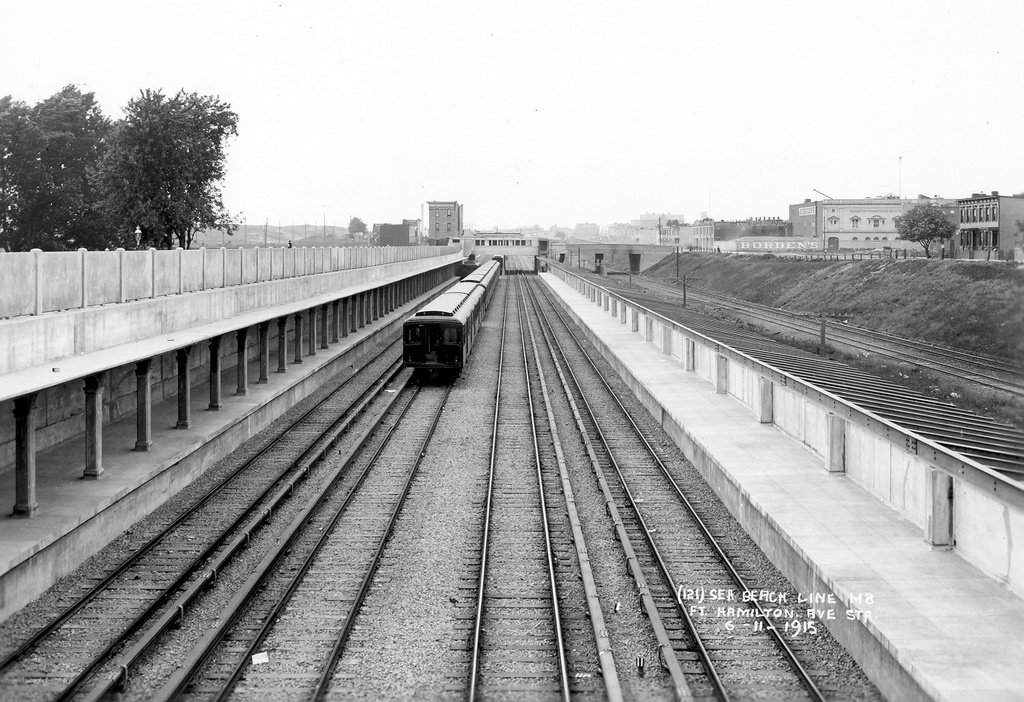
If you take the N train to Coney Island on a nice summer day you will notice that once the train exists the 4th Ave Subway, it runs “above ground”. Rather, it runs along an open cut. The casual rider might notice that there exists a set of tracks down in the center of this cut that the trains don’t seem to use. It makes sense that they would be there, since afterall most subways in NYC feature a set of local and express tracks. Even the 4th Ave Subway has 4-tracks.
But these “express” tracks don’t actually connect to anything. The connection between the open air section of subway and the tunnel under 4th Ave is only 2-tracks, not 4. So what exactly are these tracks doing here?
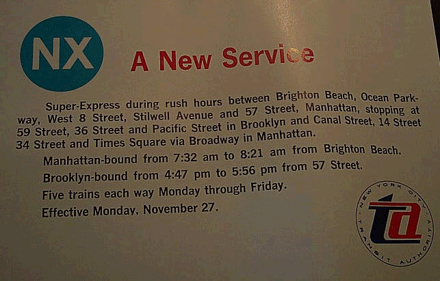
These tracks were, in fact, once used, although not for long. Summer weekends between 1924 and 1952 saw special Coney Island bound express trains which terminated at Chambers St. In 19687 as part of the greater Chrystie St Connection reorganization of train lines, the “super-express” NX train was introduced. This service ran from 57th St/7th Ave to Brooklyn, down 4th Ave, and then through Coney Island to Brighton Beach. Riders were a bit perplexed as once it reached Stillwell Ave it seemed to go the wrong way. Oddly, it only ran from November 1967 to April 1968, totally missing the summer beach traffic!

Since they were hardly ever actually used, why were these tracks built in the first place? While it’s assumed that express service was the intent, I’ve found something that points to another use: access to barges in Sunset Park.
Like the other subway lines to Coney Island, the Sea Beach began its life as a steam railroad. It ran an odd course, not into Brooklyn, but through the former towns of New Utrecht and Gravesend (this is before the city of Brooklyn annexed them in 1894.) The rails began at the 65th St pier and ran south/southeast to Coney Island. Brooklyn, at this time, ended at 60th St.
Passengers would board ferries in Manhattan going to 65th St, bypassing Brooklyn, then change to the train to Coney Island (The West End Line ran a similar service with ferries to 39th St and then on a steam train down the middle of New Utrecht Ave.) At 65th St the Sea Beach Line ran parallel to the LIRR Bay Ridge Branch, which it was separate from. Later, electric trolley wires were added so that BRT cars could connect from the 5th Ave El.
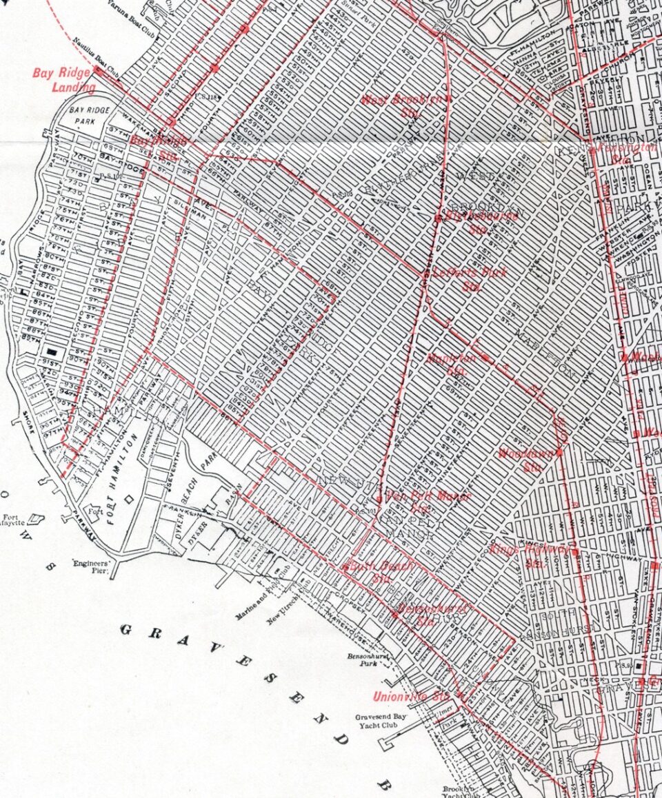
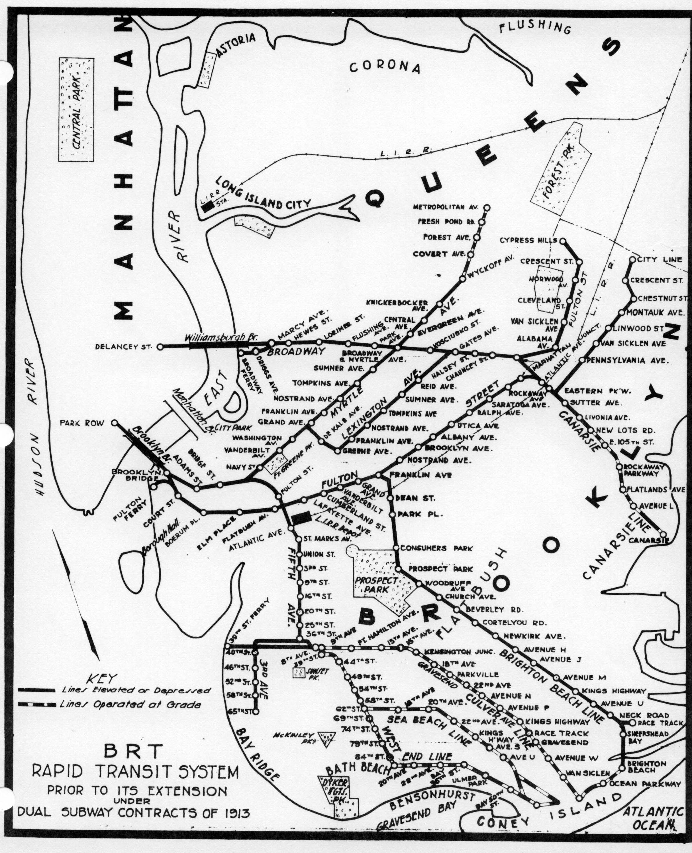
The map below shows the elevated train lines of the BRT as they were before the system was greatly expanded for the Dual Contracts. Elevated trains would often run on the electrified rails of the former steam railroad lines, and trolleys would often be routed along them as well. Here we see that the Culver Line (F train), Sea Beach Line (N train) and West End Line (D train) once ran “at grade” or even down the center of city streets before they were elevated.
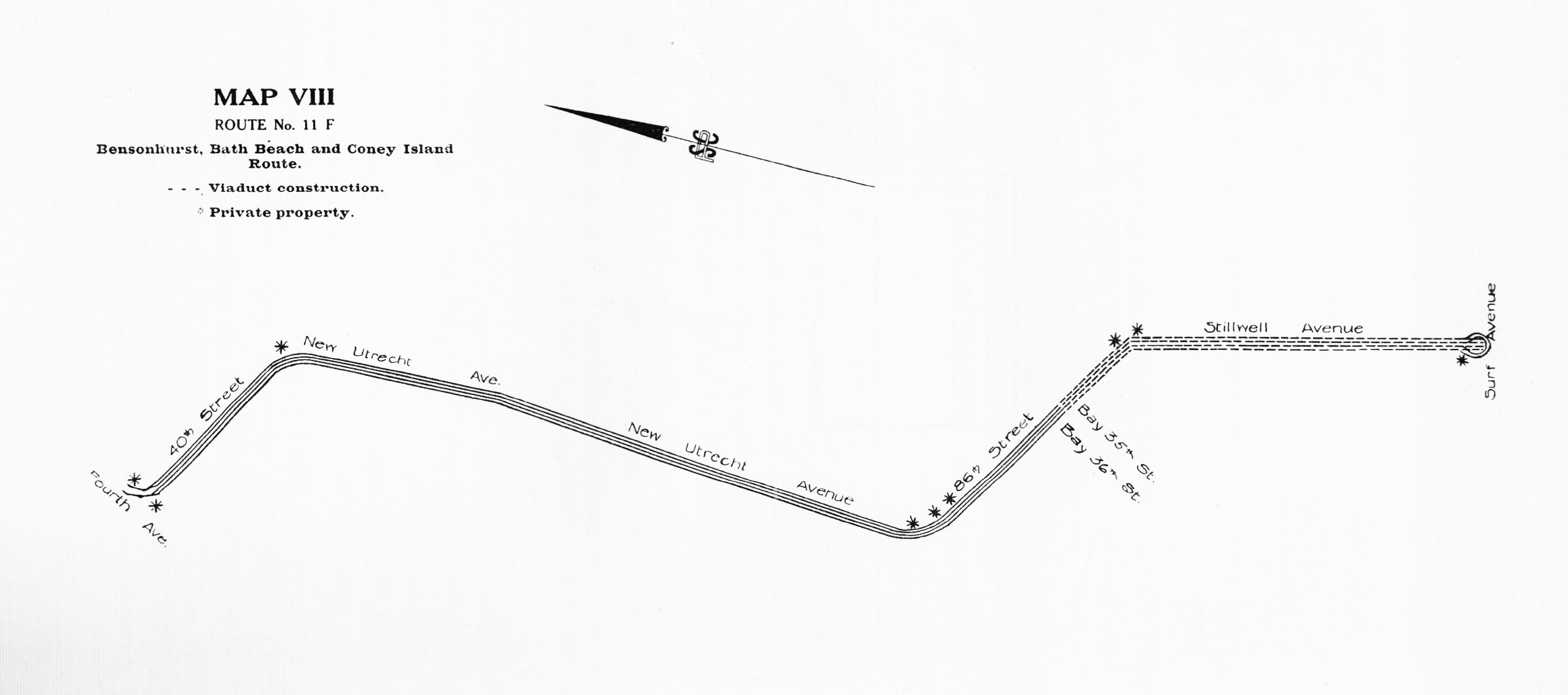
When the city began to plan the 4th Ave Subway in Brooklyn they initially wanted to have two, 4-track branches; one to Bay Ridge and the other along New Utrecht Av. Initially the subway between Atlantic Ave and 40th St was to be 4-tracks, then south to 100th St built as 2-tracks which could have two more added later. At 40th St the city built a massive 4-track flying junction for a proposed 4-track New Utrecht Ave subway line (map below). During construction, plans were changed to convert the West End Line into an elevated train line instead and connect it a block north. The flying junction was built but was never used.
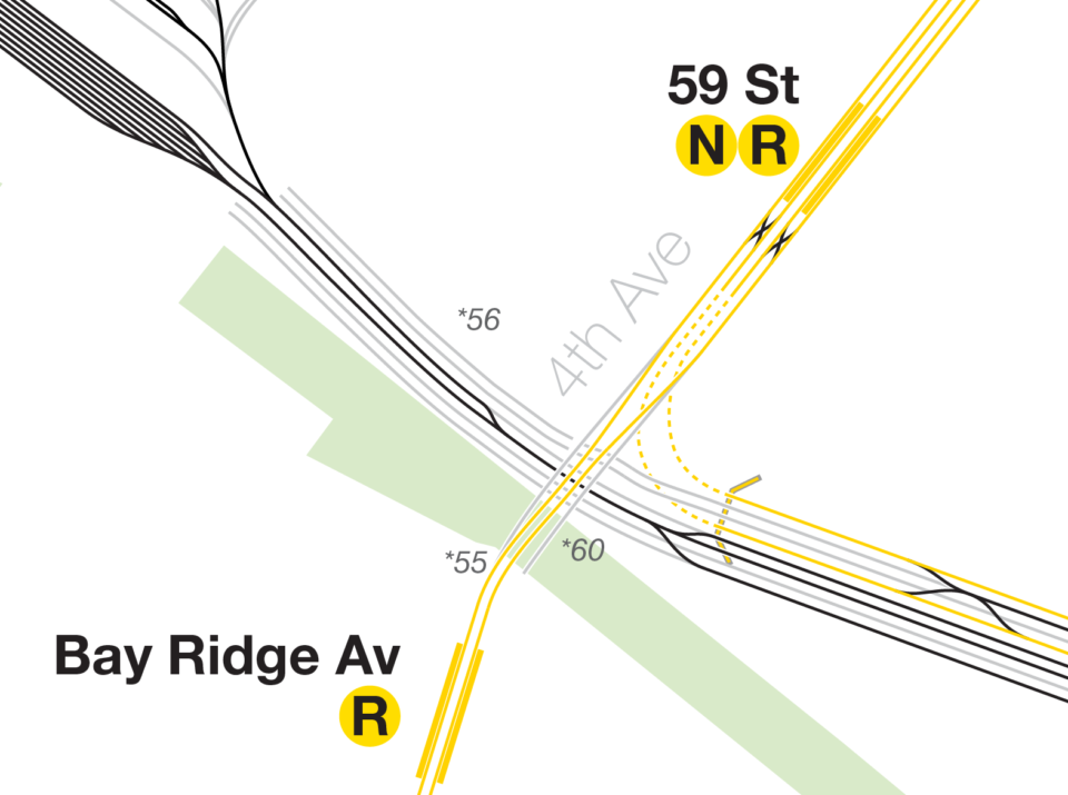
South of 40th St, the 4th Ave Subway was built with 4-tracks to 60th St where the express tracks would split off to connect with the Sea Beach Line (which itself was being expanded from a 2-track, at grade railroad into a 4-track, grade separated line). Two more tracks continued to Bay Ridge with provisions for two more to be built later, as well as a branch to the never completed tunnel to Staten Island.
Part of the Dual Contracts allowed for conversion of existing steam/electric/elevated lines into subway service by expanding the tracks for modern subway needs. This included expanding the Sea Beach Line to 4 tracks.
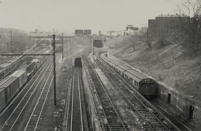
In this photo from the 1920s you can see the 4 tracks of the Sea Beach (and the LIRR to the left). There are three tunnels in this picture, as well as a bridge. From left to right, the new 4th Ave bridge would allow the LIRR to pass under the new 4th Ave subway, which runs on a lower level than the roadway. Next, the southbound Sea Beach local track tunnel, which it uses to connect to the 4th Ave Subway. Above that is a previously unknown tunnel which appears to allow for the middle, or express, tracks of the Sea Beach Line to continue east past 4th Ave. Lastly, being obscured by the train, is the northbound Sea Beach local track as it connects to the 4th Ave express tracks.
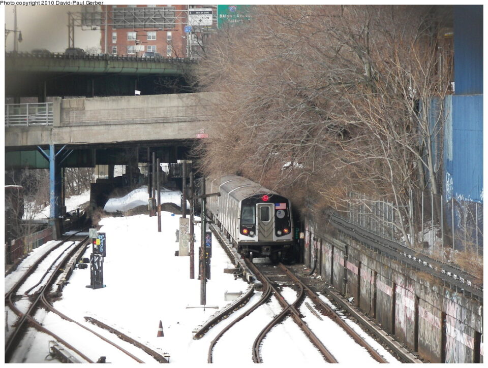
In this modern picture one can see the old ramp still exists, with rails removed and partially demolished to make space for the Gowanus Expy. The ROW of these center tracks past 4th Ave were destroyed by the construction of two massive apartment towers. According to some intrepid urban explorers, the tunnel itself may not exist anymore, but if it does, it is most likely used for utilities and is sealed off. The foundations for the towers left some space for a track way, but it’s unknown just how much of the original ROW remains.
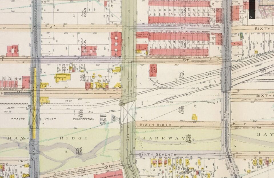
From this 1924 aerial image we can clearly see the “express” tracks diverging from the main line of Sea Beach and using a second tunnel under 4th Ave. It looks like they continue east to the docks.
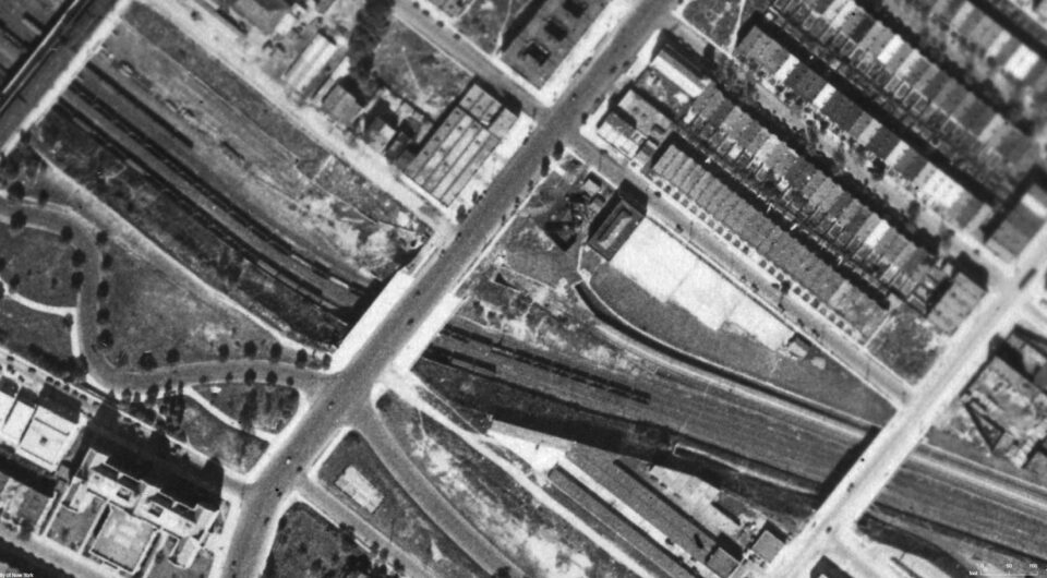
These tracks appear on the 1920 fire insurance map and appears to show that these tracks went to the old Sea Beach Line pier at 65th St. Service on the above ground portion of the “new” Sea Beach Line subway was operated before the connection to the 4th Ave Subway was finished. This would suggest that the new subway service briefly mirrored that of the old steam railroad, serving ferry passengers at 65th St. Of note on this map is the old 3rd Ave El (which was a branch of the 5th Ave El running through Park Slope.) While it isn’t indicated on the map, it’s possible that there was a temporary station built at 3rd Ave to facilitate transfers.
With the opening of the 4th Ave Subway, the need for both ferry service and the 5th/3rd Ave Els in Brooklyn ceased. Service on the new lines began in 1915. However, the Coney Island Maintenance Facility did not open until 1926. This means that for the intermediate decade, subway cars needed to be accessible to the freight yards in Sunset Park. This would allow barges to bring in subway cars on floats and would have been possible at both 65th St and at 39th St. Once the new maintenance facility was open, both car floats were redundant. The South Brooklyn Railroad at 39th St provided better access to more lines, as well as the 38th St Yard, so connection at 65th was cut.
With the decline of Coney Island as a summer attraction, dedicated express trains were less and less useful. Given that these tracks bypass ALL Sea Beach Line stations, bringing back any type of super-express would most likely do more harm than good. Express service on the Brighton Beach Line (B train) is very popular and express service on the Culver Line (F trian) was implemented, but is limited due to bottle necks in the system. There was express service on the West End Line (D train) at different times but due to capacity limitations on 4th Ave, modern express service isn’t likely.
For the Sea Beach, the issue is that the line just goes too far out of its way to have any useful express service. All the other lines will beat it in time. Not to mention, the N faces the same constraints as the D so no extra service would be possible to add.
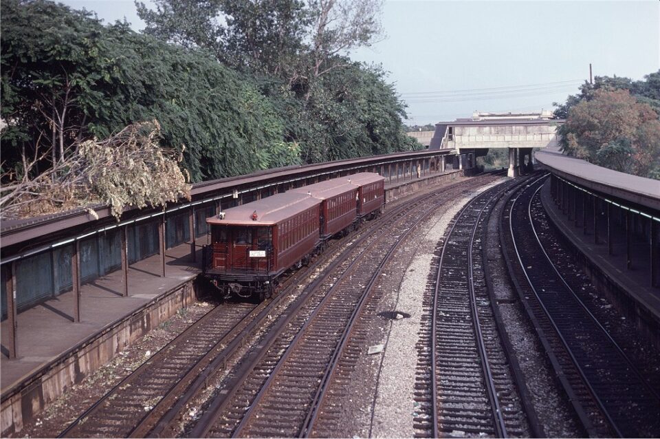
The tracks have seen use recently, although not as you might expect. In 2019, the MTA undertook a rehabilitation of the stations along the Sea Beach Line. In order to keep service running, temporary platforms were built on the unused track way. When the northbound track was taken out of service, trains used the active middle track going north. When the southbound track was taken out of service, trains used the middle track and northbound trains went back to their normal operations.
What I’m curious about is if the tunnel at 65 St is still there. It may have been sealed off, but I hope it wasn’t filled in.
What if New Utrecht Avenue on the sea beach line got upgraded to an express station?
You are still cutting service to the Sea Beach and bypassing most of the stations. That would make trains more crowded and waits longer.
In hindsight, I do wonder if the track could have been repurposed, and connected south to the Bay Ridge line so that R trains don’t have to back up the 4th Avenue line.
That’s not the worst idea, actually