map – Page 2 – vanshnookenraggen

vanshnookenraggen logovanshnookenraggen

map – Page 2 – vanshnookenraggen

vanshnookenraggen logovanshnookenraggen
Skip to content
  • /home
  • /store
  • /biography
  • /press and podcasts
  • /track maps
  • /historic maps
  • /futureNYCSubway
  • /futureMBTA
  • /unbuilt highways
  • /urban exploration
  • /hyperreal cartography
  • /QueensLink

Archives

Categories

  • Bluesky
  • Flickr
  • Tumblr
  • Email

Tag: map (page 2)

Chicago: Complete and Geographically Accurate Track Map

I am incredibly excited to release my newest map: The Complete and…
Continue reading “Chicago: Complete and Geographically Accurate Track Map”…

Worst. Map. Ever.

The MTA stepped in the right direction with its new interactive subway map. But it also stepped in shit.
Continue reading “Worst. Map. Ever.”…

Updated NYC and Boston Track Maps

I’m happy to announce a new version of the New York City…
Continue reading “Updated NYC and Boston Track Maps”…
Chystie St Connection Poster

Celebrating 50 years of the Chrystie Street Connection

On November 27th, 1967 there was chaos on the New York City…
Continue reading “Celebrating 50 years of the Chrystie Street Connection”…

Boston MBTA: Complete and Geographically Accurate Track Map

Large format prints are available at my vanmaps.com store. I was more…
Continue reading “Boston MBTA: Complete and Geographically Accurate Track Map”…

NYC Subway: Complete and Geographically Accurate Track Map

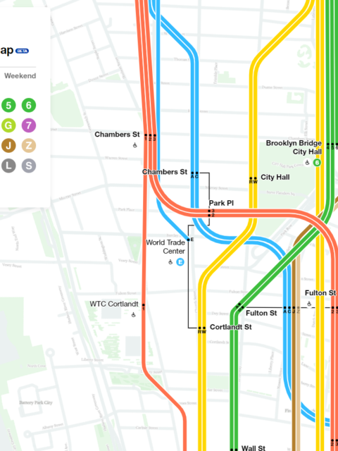
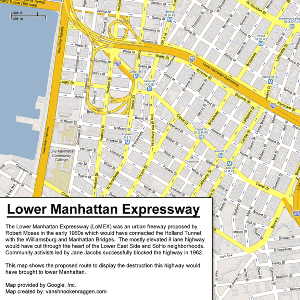
Collecting every historical map I could find, using GIS data, satellite imagery (both current and historic), YouTube videos of fan trips, my own observations looking out the window of trains through tunnels, and talking to retired track workers I was able to draw what I believe to be the most accurate track map of the NYC Subway ever.
Continue reading “NYC Subway: Complete and Geographically Accurate Track Map”…

Would the 42 St Shuttle be better if it ran to Herald Sq and Penn Station?

While digging through old subway plans on Archive.org I found this odd…
Continue reading “Would the 42 St Shuttle be better if it ran to Herald Sq and Penn Station?”…
The Unbuilt Highways of Robert Moses

Unbuilt Highways of New York City and Robert Moses

Few people loom as large in the annals of New York City…
Continue reading “Unbuilt Highways of New York City and Robert Moses”…

NYC Subway Ridership Visualized

Every year the MTA releases ridership data for its subway and bus…
Continue reading “NYC Subway Ridership Visualized”…

Gramercy Before Gramercy, 1807 vs 2013

To even the most seasoned New Yorker the city south of 14th…
Continue reading “Gramercy Before Gramercy, 1807 vs 2013”…
MBTA Animated History: 125 Years of Growth

An Animated History of the MBTA

[UPDATE: This map was originally published in 2009. Since then, the MBTA…
Continue reading “An Animated History of the MBTA”…

Unbuilt Street Grid of West Fenway

Map Reproduction Courtesy of the Norman B. Leventhal Map Center at the…
Continue reading “Unbuilt Street Grid of West Fenway”…
« 1 2 3 »
© 2025 vanshnookenraggen | Using Receptar WordPress theme. | Privacy Policy | Back to top ↑