
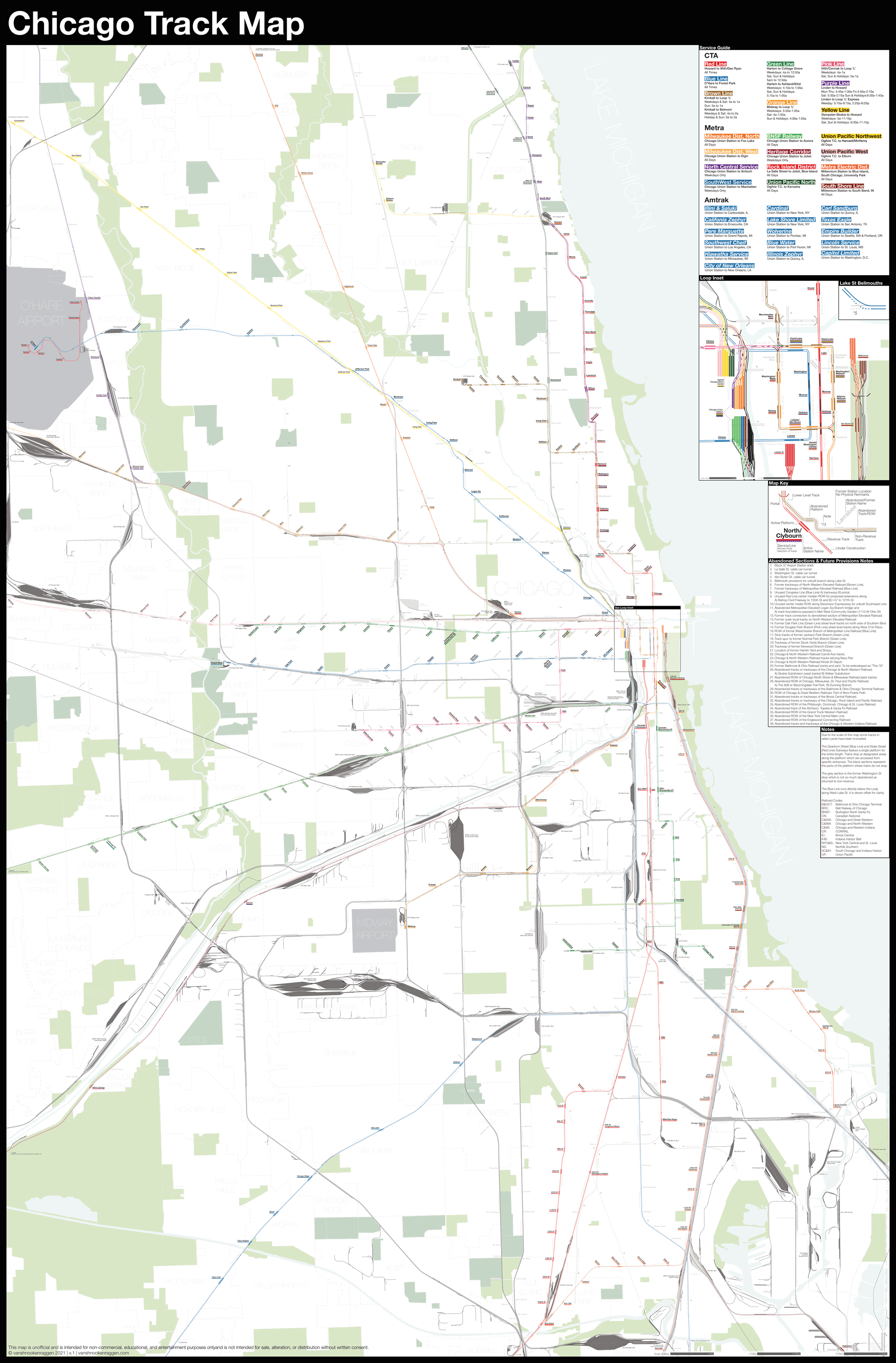
I am incredibly excited to release my newest map: The Complete and Geographically Accurate tack map of Chicago. With this map I have attempted to show the complex and detailed history of rail in America’s most important railroad city. For me it isn’t just about what is there but what was there too. Chicago had more miles of track than any other US city and even though much of this network has been abandoned over time, much remains.
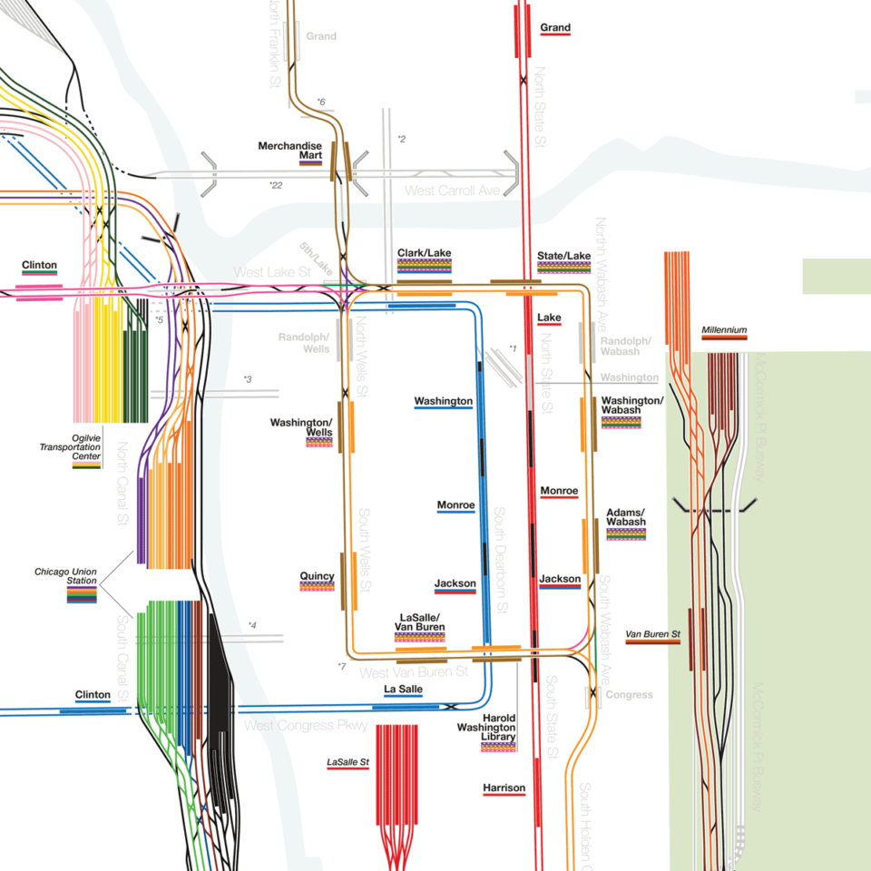
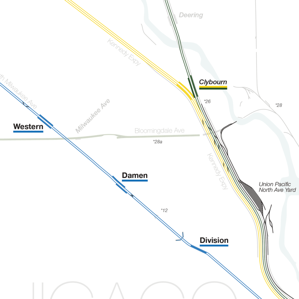
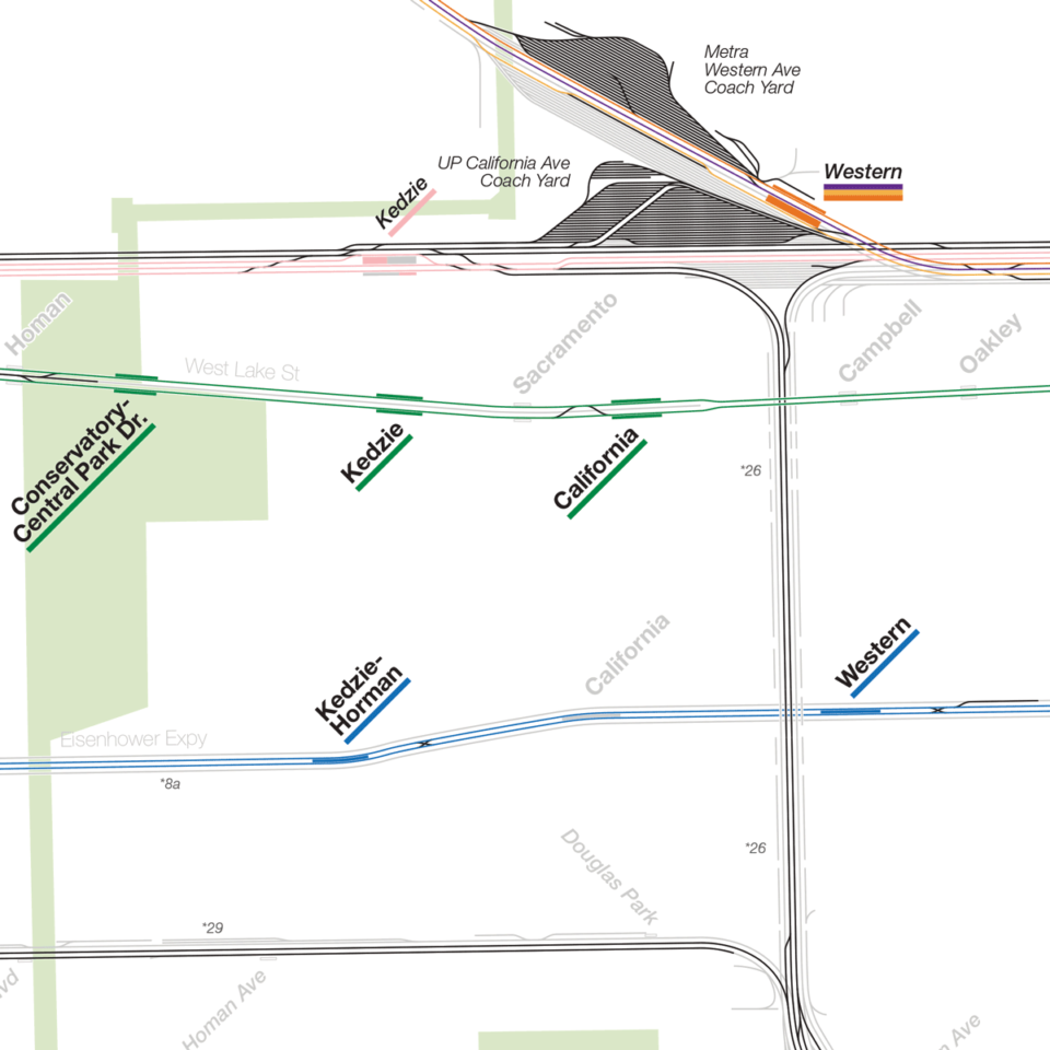
The history of the famed Loop and elevated lines of Chicago is similar to that of New York with private companies competing, only to eventually be unified. The early Els acted more like light rail and had many more stations, closely spaced, which created long travel times. In the 1947s the newly created Chicago Transit Authority took a meat ax to the system and cut out dozens of stations. Where nothing physical remains of these stations I created a new ghost station label.
Chicago was (and is) the rail hub of the nation, taking in grain, livestock and produce from the west and shipping it east. Likewise, the railroads moved millions of immigrants from east cost ports to new homes in the west.
After World War 2 much of this vast rail network was rendered obsolete by the automobile, highways, and improvements in rail technology. Today the city is full of abandoned rails in the streets and along embankments cutting off neighborhoods.

Chicago continues to evolve; Many of the abandoned rail yards have been redeveloped or are slated to be. Some of the abandoned lines have been converted into parks, including the spectacular and wildly popular 606. Others may see new life as rail congestion becomes ever more of an issue. Chicago is lucky that it still has such a resilient network and room to evolve.
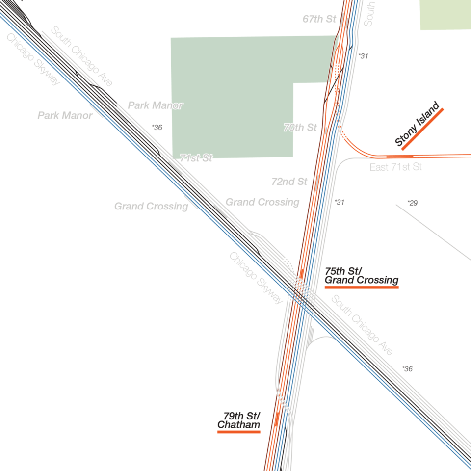
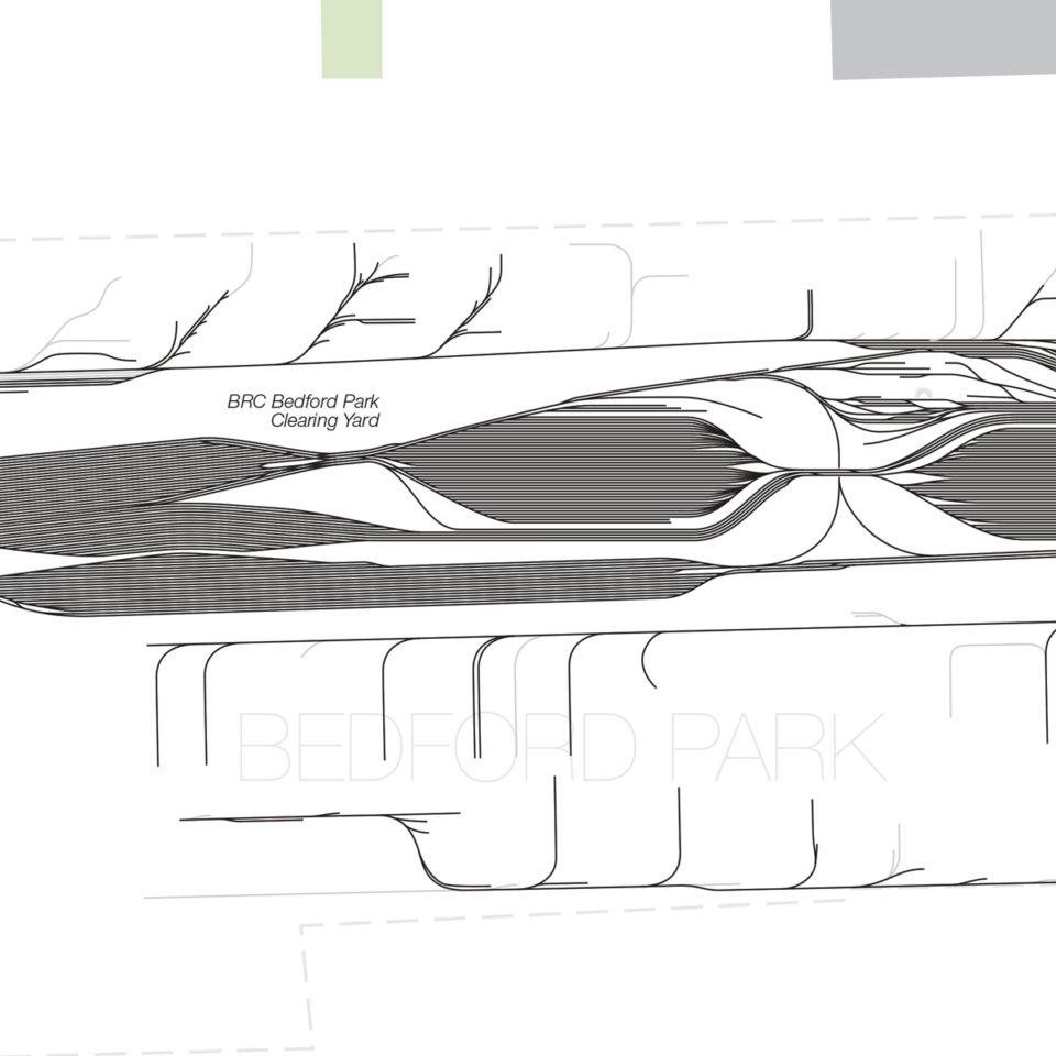
One way I try to show this is by showing the remnants of past rail yards. In many cases these old yards sit completely abandoned and overgrown. In some cases they have been redeveloped. For these, if the area where tracks once were is not built upon (that is, if it is just a lawn, parking lot, park, or open space) I show what was there. But if there was a building constructed, any remnants of the tracks are gone and I don’t show it.
There are probably miles worth of spurs and sidings that once went to factories throughout the city. I will never be able to identify and label each one. So the majority of the abandoned lines are labeled based on who owned them. This gets complicated as well since railroads have changed hands and names countless times. I chose to stick to the names as they would have been in the mid 20th Century before the highways decimated rail in the US.
I am reasonably confident that I have as close to a complete picture as there is. However, I know there are those which know far more than I. What has now become my favorite part of releasing a new map is the conversations which happen after. If you see something that is missing, or wrong, or something that needs to be fleshed out, please leave a comment, hit my up on Twitter, or email me. I strive to create the most accurate maps and I can’t do it alone.
This map is also on pre-order on my store. As I expect a round of post-release updates I would like those who buy my map to have the most up-to-date release. I expect that I will start printing and shipping the prints in January.
When life gives you lemons, make lemonade. I cannot think of a more lemon filled year than 2020. With Covid related shutdowns putting me out of work for most of the year I chose to look on the bright side and take this time to work on projects which had been sitting on the backburner. None was bigger than this: the Complete and Geographically Accurate track map of Chicago.
This is a map I began in the summer of 2018. At the time my plan was to draw just the tracks of Chicago’s subway and el network. But unlike New York and Boston, both cities in which I’ve lived and researched over many years, I’ve only been to Chicago a handful of times and didn’t know the history of its rail network. I was soon over taken by mission creep as I felt I needed to add more and more to properly tell the story of the city through its rail network.
I had designed these maps to show just the passenger rail rapid transit networks but in Chicago that line is more blurry. I decided to show the commuter rail network too but found that it was intertwined with the freight network. I finally said “screw it” and decided that I would attempt to draw every track in Chicago. Every track that exists and every track that once existed (not including streetcar lines now long abandoned).
6 months passed and I was hardly half way there so I put it on hold. But in that time I learned new drawing techniques which made creating these monsters go quicker. After I put this map on hold I decided to go back to my New York and Boston maps and update them with the other rail tracks I knew existed to paint a more true picture of these cities. The updates I released last year owe their existence to the Chicago map.
With Covid giving me more time than I ever wanted to work on my maps I decided I no longer had an excuse. 6 more months went by and here we are. Because I don’t know Chicago as well as NYC or Boston I had to research as I drew. The complex history of railroads, which change names and owners many times throughout their history, led to much confusion and lost time.
That was just for what is there now. I had to also research historic maps and old aerial imagery to determine what the abandoned sections were. Old maps aren’t as accurate as you’d imagine since many times they were produced by the company as propaganda. Many times railroad maps would show stations which almost never existed as a way to attract investors.
But then that research is half the reason I make these. I hope people get as much enjoyment from these kinds of maps as I do and I look forward to learning more and filling in the gaps.
This. Is. Spectacular.
I wasn’t aware that the Blue Line section from UIC-Halsted to Forest Park was equipped with extra trackways. I just looked it up on Wikipedia, and it appears they were meant for extra Chicago Aurora and Elgin Railroad service into the city, or maybe for a new loop subway.
Great work, and very interesting to peruse. I did find a couple of errors:
– Kedzie-Homan on the Forest Park Blue Line is misspelled
– The old Homan station on the Lake St Green Line is shown to the west of the current Conservatory stop, but it was actually a couple of blocks to the east (along the eastern border of Garfield Park)
I must purchase this if only to learn the location where the B & O crossed the Nickel Plate in southeast Chicago.
Would be nice if you could extend the western boundary a mile or two to include the full Bensenville Yard and the western edge of Proviso… They’re cut off and truncated as it is right now.
these maps are really interesting, thanks for making them.