
In the previous post, I looked at many of the challenges of using the Hell Gate Bridge for the IBX between the Bronx and Queens. Much of the constructive feedback I received asked about a new tunnel instead of using the bridge. Some folks still asked about going to LaGuardia Airport (LGA). Interestingly, no one asked if a new bridge was feasible. In this post, I want to explore why and how the IBX could be extended north, why a new bridge is actually feasible, and where the IBX should ultimately go.
IBX North
The current northern terminal of the IBX is Roosevelt Av in Jackson Heights. While this is likely the best possible terminal in terms of multi-modal connectivity (multiple subways and buses serve this station complex), it still leaves out major job centers and connections to other lines to the north. The predecessor to the IBX, the RPA’s Triboro Line, proposed extending service into the Bronx with two branches. The first was along the 149th St corridor, connecting the 6, 2/5, and 4 trains, along with a proposed new Metro North station at 149th St. The second branch ran up along the Northeast Corridor (NEC) to Co-op City. At first glance, these alignments seemed to be placed along existing (NEC) or former (149th) rail corridors. In actuality, these two branches were designed to serve major areas of employment in the Bronx.
The 149th St corridor, better known as The Hub, is the historic downtown of the Bronx. Multiple rail, elevated, and subway lines connected riders from all over the borough here. Today, the area is home to a major hospital complex, the Lincoln Medical Center, which makes up 44% of the jobs in the area. In total, there are over 39,000 jobs in a 3/4th mile radius around 149th St and 3rd Ave, the center of The Hub [Source: OnTheMap]. Presently, this area is served by the 2/5 trains, and both the 4 and 6 trains are about a half mile away.

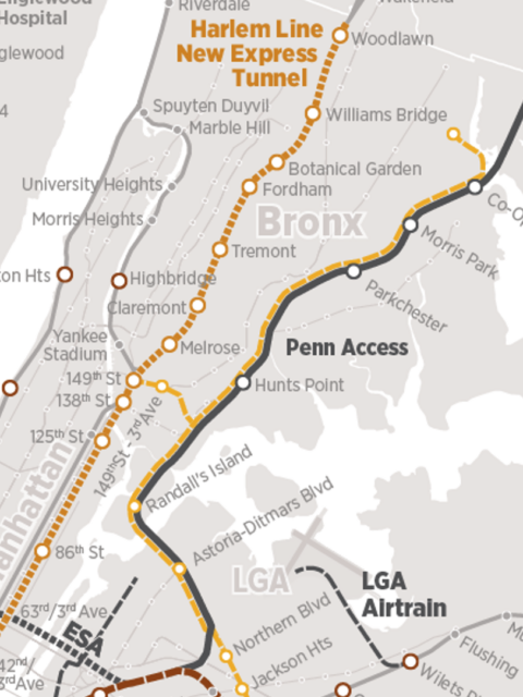
The NEC corridor is home to major hospitals and institutions as well. With over 100,000 jobs in a one-mile radius around the corridor [Source: OnTheMap], it’s probably the most important transit corridor *not currently* served by transit (the 5 and 6 trains are both over a half mile away.) This, of course, is changing with the Penn Station Access (PSA) project that will upgrade the corridor through the Bronx and add four new Metro North stations.
Lastly, there is LGA. In 2024, the airport saw over 33.5 million passengers pass through the facility. There have been a number of attempts to extend rail transit to LGA going as far back as the 1940s, when the airport first opened. Famously, the most recent attempt, an AirTrain from LGA to Willett’s Point, faced community push back and was canceled when it’s biggest champion, Gov. Andrew Cuomo, resigned in disgrace. Advocates had called for the MTA to extend the NYCT Astoria Line (N/W trains) to the airport instead, but a subsequent Port Authority (PANYNJ) study concluded that, due to issues related to heavy construction near the runway, only improved bus service would be cost-effective.
As I covered before, the Bronx has very good north-south rail transit coverage. What it needs is crosstown, east-west coverage. Theoretically, this dovetails naturally with the IBX, which connects Brooklyn and Queens in a similar crosstown manner. But, while the IBX has a natural path through those two boroughs (along the LIRR Bay Ridge Branch), the proposed Bronx corridors are less simple.
The 149th St alignment would cross the Bronx at the southernmost effective corridor (that is, the southernmost corridor that connects multiple radial lines.) But as a crosstown service, it requires the majority of Bronx riders to go out of their way to cross the borough; A rider from the northeast Bronx has to travel all the way south before double backing up the west side. If we consider that the most heavily ridden buses in the Bronx are further north, especially along Fordham Rd, the 149th St corridor may not be the best to serve this function.
Extending the IBX along the NEC changes the nature of the IBX from a crosstown line to a radial line. The only connection to the existing subway network would be at Hunts Point Av (6), and this would force most riders to transfer. If the IBX is to fill the role of a crosstown line, the line must reach deeper into the borough. Aside from the added cost, this would suddenly render much of the line redundant to existing radial subway lines. It would not serve the boroughs crosstown needs, and be bad at serving its north-south needs as well. The future Metro North service to Penn Station will serve the corridor very well, getting riders to Midtown in about 20 minutes. An additional IBX service would require its own set of tracks, and likely not see as much ridership.
Northern Nexus
If using the Hell Gate Bridge is not feasible, and the two logical Bronx alignments don’t hold that much water, where can the IBX go that would best serve the city? Within each outer borough, there is a nexus point where the majority of transit lines meet, then spread out. You’ll find this in downtown Brooklyn at Atlantic and Flatbush Aves, and in Queens at Queens Plaza. It is no surprise that the only existing circumferential transit line, the G train, runs between these two places.
In Upper Manhattan and the Bronx, the nexus isn’t a point, but a corridor. Almost all of the major trunk lines begin to branch after they cross 125th St (the IRT Broadway-7th Ave Line does branch at 96th St.) While 125th St itself is only tied together by the M60 bus, this is a very popular bus, and the MTA has rightfully eyed the corridor for an extension of the 2nd Ave Subway. 125th St is also where Metro North stops before branching.

The IBX is less about a one-seat-ride and more about connections to other lines; serving Harlem-125th St actually supports it’s main goal. 125th St is the one location where the IBX can go which serves the most riders with the least amount of redundant coverage. Every rail service in the Bronx is accessible (directly or indirectly) from the Metro North Harlem-125th St and Lexington Ave 4/5/6 (and eventually Q) complex. This makes Harlem-125th the ideal terminal for a northern extension of the IBX.
A Harlem extension has other benefits as well. By simple geography, Astoria to Harlem-125th is a shorter distance than 149th St, or anywhere north of there. By tunnel or by bridge, this is cheaper. A Harlem-125th St extension only requires one station, between Park and Lexington Aves, to service most of the Bronx. Should a cross-125th St 2nd Ave Subway extension have been built by the time any of this is actually considered, Upper Manhattan will have access to Queens as well. Alternatively, to get the same coverage in the Bronx, longer tunnels and multiple stations would be required. This is, not surprisingly, the same logic that led the MTA to realign the 2nd Ave Subway across 125th St instead of continuing it to the Bronx.
The Hell Gate Crossing

How do we get the IBX from Jackson Heights to Harlem? When the MTA claimed that the IBX couldn’t fit over the Hell Gate Bridge, and that a new bridge would be needed, most people dismissed the idea outright. In the days of Robert Moses, the city could condemn land for the approach roads. But today, the same level of land taking is seen as too costly, both for the people affected, and for the property values the city would be covering.
Extending the IBX as a subway might be the most obvious solution. But with NYC transit construction costs being world record breakers, it’s hard to see how a tunnel under the East River would work out. The geology below the Hell Gate Bridge is what helped give the strait its reputation and name. This is the narrowest point in the East River, which is in fact not a river at all but part of the Long Island Sound. Here, strong currents have cut a deep channel under the water. Building an immersed tube tunnel (which involves building the tunnel structure offsite and lowering it into the water) would be far too treacherous in these waters. Deep bore tunneling here would need to be especially deep, over 100’, making it very costly.
Would it be feasible to retrofit the Triborough Bridge to support the IBX? Most likely not. Like all Robert Moses bridges, the spans were never designed for rail transit. There was never a consideration for a second deck, and placing rail on the outer edges of the deck would likely result in uneven loads which would cause the bridge to twist in ways that it was never designed for. This is similar to what happened with the Manhattan Bridge (which was designed for transit), where the trains passing on either side of the bridge put stresses on the bridge that caused it to deteriorate at a faster rate. The Triborough Bridge is a much lighter design, and would likely snap with rails added.
The Plan
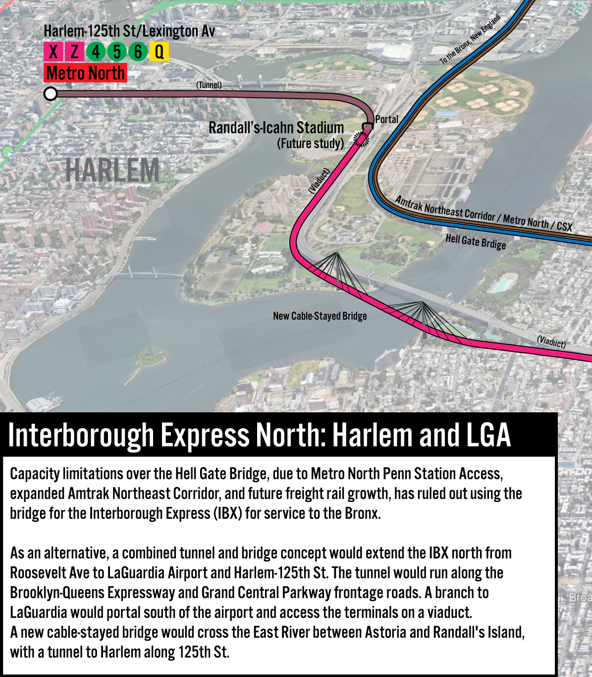
To begin with, we must first locate a location between Queens and Randall’s Island where a new crossing even could be built, with absolute minimal land taking. There is, in fact, one location where a new bridge could be built: between the southern tip of Randall’s Island and Astoria Park South, paralleling the Triborough Bridge.
This location works for three reasons: the first is that it’s far enough outside the flight paths for LGA [PDF] for the necessary height of the bridge. Second, it’s the only location where a subway tunnel (which is required in Astoria to get around the Hell Gate Bridge approach) has enough room to rise from underground to cross over the water. Third, it’s the only location where virtually no buildings would need to be taken to construct the bridge or its approach. If we use this crossing location and work backwards, we can find the perfect solution for a northern extension of the IBX.
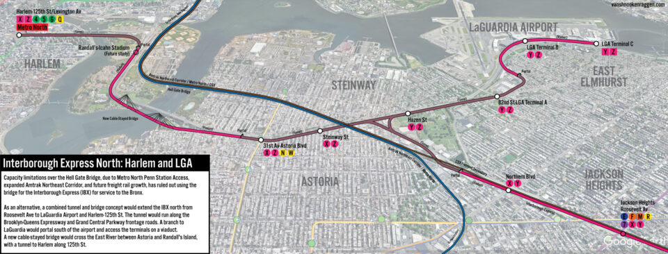
Starting at Roosevelt Ave, the IBX will continue along the western side of the Fremont Secondary, crossing over the Brooklyn-Queens Expressway. A new station will be built at Northern Blvd. Continuing north, the IBX will begin to dive into a tunnel portal between 31st and 30th Aves, allowing the IBX to pass under the Fremont Secondary track and eventually the Hell Gate Bridge approach viaduct. From 30th Ave, the IBX tunnel will curve northeast until it reached the BQE West frontage road. The western branch of the BQE has two frontage roads, which the eastern branch lacks. Building a tunnel along these frontage roads will be less complex than trying to build along the eastern branch, which would require building along either a residential street, or St. Michael’s Cemetery.
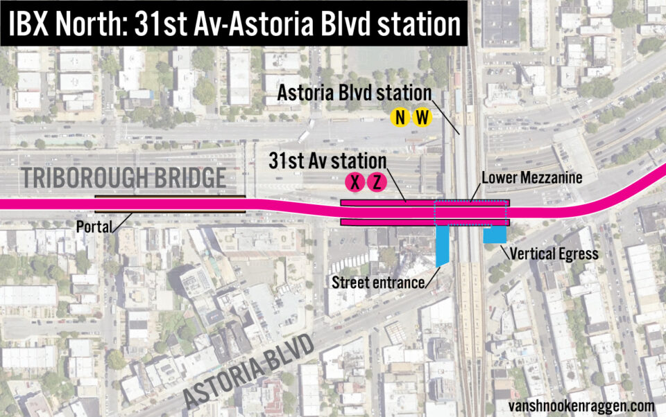
The IBX tunnel will run north along the frontage road to 47th St, turning west along Astoria Blvd South to 31st St. There will be stations at Steinway St and 31st St for a transfer to the N/W trains at Astoria Blvd station. The Astoria Blvd-31st St station will be located under the bridge off-ramp to 31st St and Hoyt Ave South, and will require taking of two small commercial buildings at the corner to allow for vertical egress between the elevated and subway stations. During construction, traffic will have to be rerouted along 29th St and Astoria Blvd. When open, the existing traffic pattern will be restored. Good vertical access will be important here because this station will see high numbers of riders transferring from the subway on their way to and from LGA. The Roosevelt Av station will likely become overcrowded with IBX riders transferring, so the Astoria Blvd station will help ease the load.
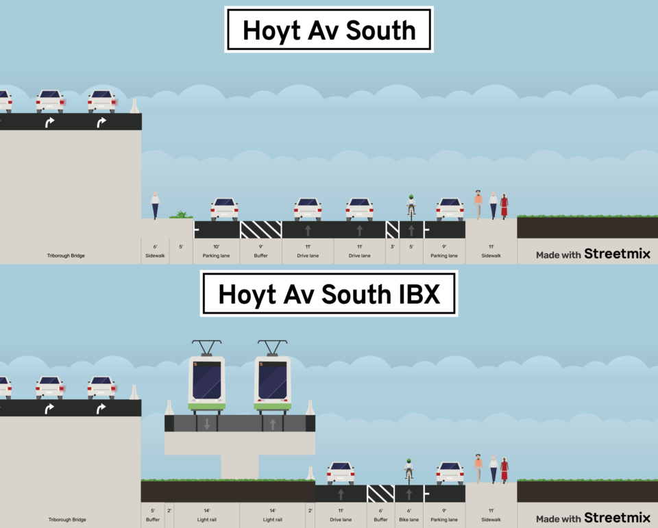
Along Hoyt Ave South, on the southern side of the Triborough Bridge, the street consists of a parallel parking lane, bike lane, two moving lanes, a 60-degree parking lane and a shabby sidewalk. By removing the sidewalk and 60-degree parking lane, there is enough room for a 2-track portal and viaduct to be built along the southern edge of the Triborough Bridge. The portal and trackway will be a separate structure from the bridge. This still provides space for a travel lane, bike lane, and parking lane on Hoyt Ave South (or, alternatively, two travel lanes and a protected bike lane.)
The viaduct will run along the southern edge of the bridge until 21st St, where it will continue along the southern edge of Astoria Park, allowing for more clearance between the existing and new spans. The new crossing with be a cable-stayed bridge design, with one tower just to the west of the Astoria Park Soccer Field, and the other just to the south of Randall’s Island Field #72. The bridge will have space for two tracks. There could also be space for a bike path or walking path, thought vertical access from the Astoria side would need to be worked out.
Unlike the typical suspension bridges that cross the East River, the new crossing will be a cable-stayed design. Cable-stayed bridges are a favorite of engineers for being the most efficient type of span. Unlike traditional suspension bridges, which need huge anchorages on either side of the bridge to anchor the cables supporting the deck, a cable-stayed bridge uses the cables to support the deck on both sides of the main support tower. A benefit of a cable-stayed design here is that more of the existing park space can be saved below the span. The Montreal REM uses the new Samuel-De Champlain Bridge, and Sound Transit in Seattle is proposing a cable-stayed bridge for their West Seattle Link extension.
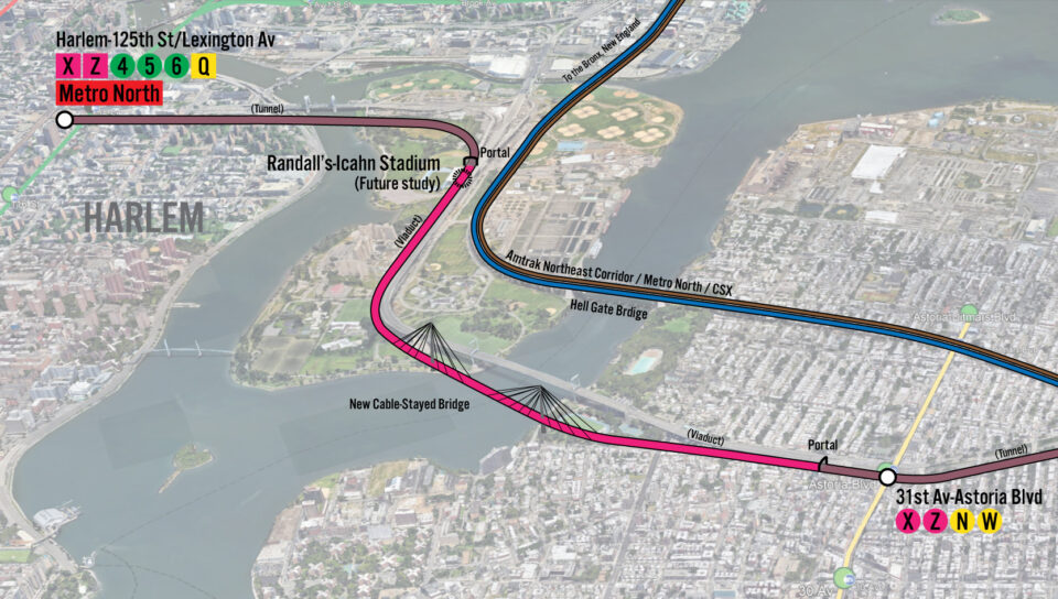
On Randall’s Island, the viaduct would parallel the Triborough Bridge on the eastern side. The line could have a station next to Icahn Stadium, though the utility would need to be studied given its limited use. The line would then turn west, paralleling the Manhattan approach to the Triborough Bridge, descending into a tunnel. The Harlem River runs along the west side of Randall’s Island and is much shallower than the East River. A TBM or an immersed tube could be used to build the short, 600 foot long tunnel under the water.
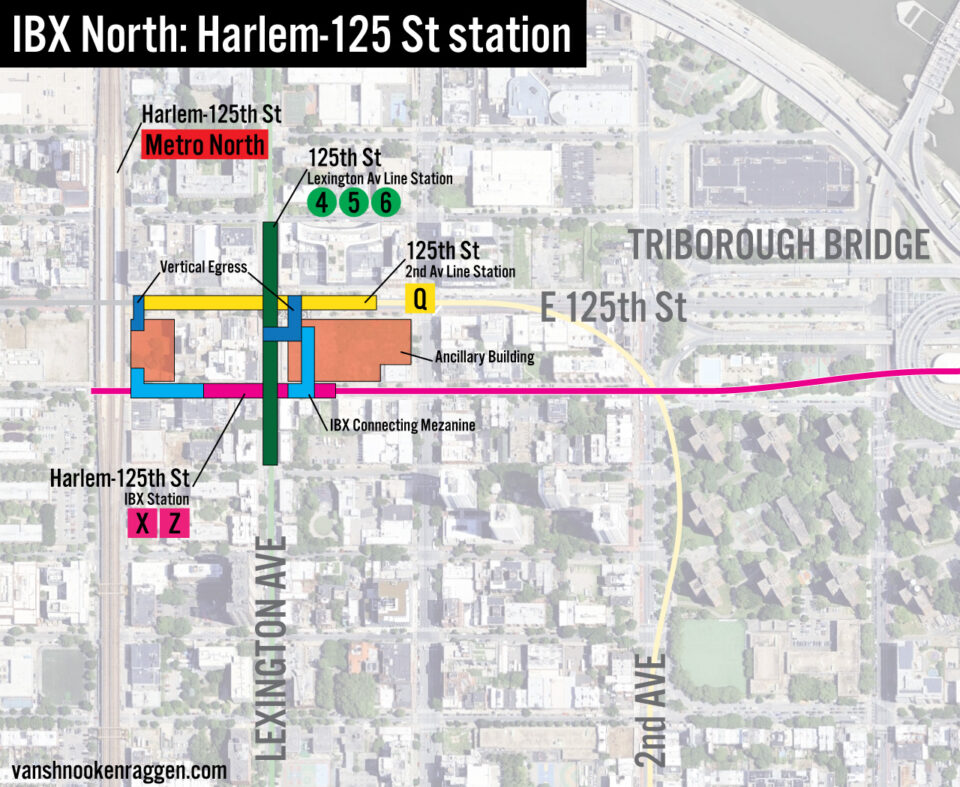
In Manhattan, the new tunnel would cut across 124th St from the East River to Park Ave. 125th St would, by this time, contain the 2nd Ave Subway extension. This extension is planned to have a large underground complex connecting to the Lexington Ave Line, as well as an entrance by the Metro North station. The IBX terminal would plug into this complex, providing in-station transfers to the 4,5,6 and Q trains, as well as a connection to Metro North. Given that this station, which already has high ridership, will see even more passengers transferring, a large platform and mezzanine will be required. The tunnel will extend past the station to provide storage space for trains.
I have not calculated whether or not a new train yard will be needed. This is mostly due to not knowing what is being proposed for the IBX yard planned at Brooklyn Army Terminal. Should additional space be needed, it may be possible to repurpose parking lots under the Triborough Bridge on Randall’s Island for additional tracks.
LaGuardia Airport Branch
An often proposed northern extension of the IBX is to LGA, directly. Given that the current Q70 SBS bus connects Roosevelt Ave and LGA already, a rail line replacing this route seems to make sense. When Gov. Kathy Hochul killed the previous AirTrain plan, she instructed the PANJNY to consider all other alternatives, including an extension of the IBX (technically, the report proposed a light rail line, but it was noted that this could connect to the IBX.) An extension of the NYCT N/W trains was also considered. In doing so, the PANYNJ built for themselves a set of parameters so strict that no project other than the cheapest of bus improvements passed the test.
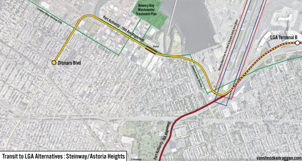
There is a large interceptor sewer and storm drain that is built virtually around the entire borough of Queens. This sewer collects waste and water from smaller sewers before it reaches the East River and funnels them into water treatment facilities; one of which is located at the edge of Astoria, just west of LGA. This sewer runs along 19th Ave, then roughly along the edge of the airport property, and under the Grand Central Parkway. The route of the NYCT N/W trains extension, as well as the light rail line, were drawn virtually along the entire route of the sewer tunnel.
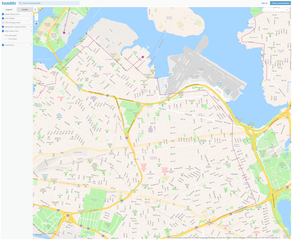
Both the sewer and much of the airport property were built through soggy wetlands, requiring them to be supported underground by hundreds of wooden piles. Wooden piles that are fully submerged don’t rot, so the continued support of both the sewer and airport requires these piles to be undisturbed. Any tunnel would therefore need to be dug especially deep (150-200 feet) to avoid both the sewer and piles. While technically feasible, the high construction cost and extra travel time to reach the surface ruled out this idea.
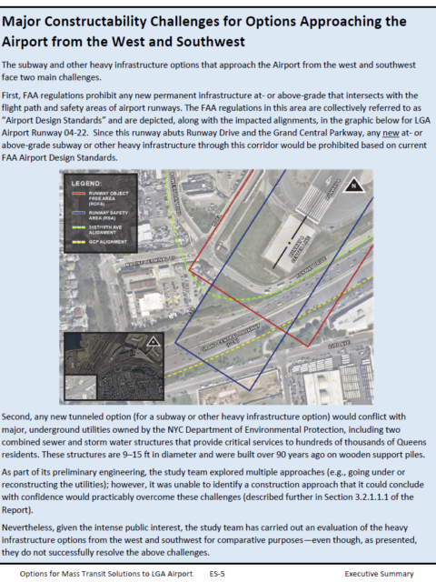
FAA restrictions prevent construction and even temporary tall structures within a certain distance from runways. This eliminates any type of viaduct would run too close to the runway. Even using cranes for tunnel construction is out. When considering extending either the NYC subway N/W trains from Ditmars Blvd or an extension of the IBX from Roosevelt Ave, the PANYNJ consultants routed both options directly through the restricted zone.
If we imagine that the PANYNJ never wanted to build the AirTrain in the first place (this was one of Andrew Cuomo’s bright ideas), it’s easy to see why they set up an unworkable plan from the beginning.
In order to find a solution that could actually work, while considering the real physical constraints, we can find an alternative route which combines the best of the NYCT N/W trains and IBX extension.
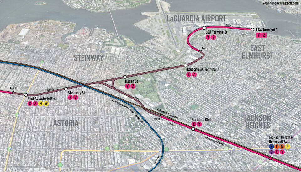
In the plan I outlined above, the IBX tunnel would hug the BQE frontage road before turning west along Astoria Blvd. Where the line turns, a branch can be constructed that would turn east, along the Grand Central Parkway. This branch would connect to both the southern leg (to Brooklyn) and western leg (to Harlem) via a flying junction, accomplished by constructing a bi-level tunnel.
The branch would continue east in a tunnel under Astoria Blvd South to 82nd St. Instead of hugging airport property, the new tunnel runs around it: at 82nd St the tunnel makes a slight turn down 24th Ave until 88th St. There would be a station at 82nd St for local riders, and for a short shuttle bus connection to LGA Terminal A, with an intermediate station at Hazen St.
The city block bounded by 88th St, 23rd Ave, 89th St, and 24th Ave contains a giant parking lot for Budget Car. This is where a portal will be built. The line will make a sharp turn north at 88th St, come above ground, and cross over the parking lot of Vaughn College on a viaduct. The line then crosses over the Grand Central Parkway, outside the restricted zone, and continues to both LGA terminals. Stations will be at Terminal B, and Terminal C.

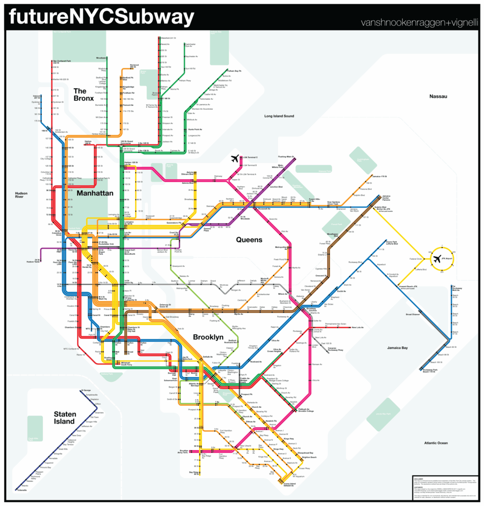
The IBX will shift from a simple line connecting Brooklyn and Queens into a complex network linking Upper Manhattan, the Bronx, Westchester Co., and LGA as well. Three services will be established: the X train from Brooklyn Army Terminal to Harlem-125th, the Y train from Brooklyn Army Terminal to LGA, and the Z train from Harlem-125th to LGA. (The existing Z train, which runs skip-stop service with the J can simply be renamed the K or something else.)
The IBX as it’s proposed today is 14.5 miles long, built along an existing ROW, with 19 stations, is said to cost $5.5 billion. Now, this number was calculated before the tunnel under All Faiths Cemetery was added (not to mention the new Trump tariffs.) My assumption is that a more realistic cost-estimate is around $7 billion, which is still a good value for what the IBX will bring.
What I am proposing is far more complex: 3.85 miles of new viaducts, 4.1 miles of new tunnels, 7 new stations, and an almost half-mile long bridge. This will not be cheap; A similar proposal for a light rail bridge in Seattle is set to cost almost $4 billion, and that is just for the bridge itself. The IBX North proposal may very well cost as much as the initial phase of the IBX, when all is said and done. Still, this is the most affordable alternative; a full tunnel would likely be twice as much, and any extension into the Bronx would add miles of new tunnels and billions of dollars.
The value, however, will be immense. Riders from Upper Manhattan and the Bronx will save hours a day from faster travel to Queens, tourists and business travelers will have a faster trip between LGA and Midtown, and New York residents will have faster trips to LGA. Westchester residents flying out of LGA will have a genuinely better alternative than driving to the airport.

Conclusion
To be clear, I don’t see a project of this scope to be a serious proposal for another 20 years. If things go right (and accounting for many things going wrong), the IBX will have been built and operational by that point. Only when the IBX is up and running will we have a true idea of what is needed and possible for a northern extension. Perhaps a bridge is still too ambitious. But perhaps the LGA extension makes more sense then. Perhaps the need to connect the Bronx and Queens is even more evident, making a new bridge more feasible. We won’t know for some time.
Having the IBX terminate at 125th St also begs the question, should we extend it to West Harlem? I’ve designed this with consideration for the fact that the MTA is looking into extending the 2nd Ave Subway west from Phase 2. In 20 years, perhaps this extension is under construction or has been opened. But if not, the IBX could fill this role as well. Time will tell.
What are your thoughts on having the Q include an eastward branch that heads to LGA in the way you outline for the IBX? This would offer a 1 seat ride from Times Square to LGA.
I don’t see the benefit of extending the Q and not the N/W. Ironically, the idea for this post started with trying to find another way to extend the N/W along an alternative route than that of the Port Authority’s sandbagged one. As that evolved, I realized that the IBX would fit the role better. What I mean by that is if the IBX is to ever be extended north, it will be pricey. So you need to find a route that gets the most ridership. Harlem to Jackson Heights is good, but LGA would be better. Could you do the N/W extension AND IBX? Maybe, but that complicates things. Who knows. Like I said, this is an idea 20 years ahead of its time.
If we consider this as a second phase to add on to the IBX, could it makes sense to have a 3rd phase to add on this by extending the line east from LGA to Jamaica, and then running over the AirTrain infrastructure to JFK? Could the AirTrain viaduct support IBX-style equipment?
No. You can get between LGA and Jamaica with a single transfer at Roosevelt. Airports don’t need to be directly connected the way other transit centers do. Yes, some people will opt to make that awkward connection. But it’s not worth spending billions on them.
I think there’s a lot of value in this, as it would provide a better connection for people coming from Long Island. Even with an added station on the IBX where it crosses the LIRR Main and Port Washington branch, many trips would require a transfer at Jamaica and another transfer to the IBX to make what amounts to three sizes of an oddly shaped trapezoid versus a direct routing to a major transit hub.
While this is a very interesting idea, I think it would be good if there is to be an eventual expansion of the IBX, that it actually go into the Bronx, rather than be yet another line going into Manhattan. Just as the currently planned IBX will allow for enhanced connections between Brooklyn and Queens, I think that a direct expansion into the Bronx, say along the 149th St. corridor, would better allow for enhanced connections between the Bronx and Queens. And do this more directly than using Harlem as an in between transfer point, in addition to better keeping with the outlying borough connection theme of the IBX.
You know, at multiple points in the past in my “casual transit mapping” adventure, I had the suggestion that the IBX could make a trip into Harlem over Randall’s Island and be the dedicated 125th Street Crosstown Line. I remember a lot of the conversation turning into commentary about the line missing Manhattan based cores and secondary cores in the other boroughs it *could* be serving and spun back around to instead extending it into the Bronx with no Manhattan interaction save for that one Icahn Stadium station before doing a stint in the South Bronx towards Yankee Stadium — its terminus.
Seeing a proposal like this again, no matter how “for the future” it is or how much there is to still scrutinize, definitely fills me with a specific amount of “actually I should be more brazen with ideas sometimes” and especially when you bring this much reasonable commentary to how and why it could be done this way. Thanks haha!
Thank you! I never claim to be original, but I do try to make it look good.
Hey, this was a very interesting read! Im sure you’ve heard about the rikers prison complex closing. And ofc its unknown what will happen to the island in the future. But assuming it somehow gets developed into a neighborhood despite proximity to LGA, would extending the IBX to Rikers, and even using the island to get to the bronx be worth it? I think that points the IBX in the better direction towards the center of bronx where the extra capacity is sorely needed. Thanks!
I had a section on this, and I removed it, but now I wish I hadn’t. Rikers Island was literally built out with poor landfill and garbage. It will never be suitable for any kind of development. Let alone, it’s too close to the airport to make for a good residential neighborhood. Tunneling through the island is a non-starter.
So would it be impossible to extend the N and W to LGA? I’m still confused bc you have both options (the IBX as well as the N and W) to LaGuardia long term
If the IBX is extended to LGA, then there is no need to extend the N/W. The image I think you’re referencing isn’t showing that I’m proposing both, rather, it’s showing both options that were studied by the Port Authority and shown to be infeasible.
There has been a need for a cross-Harlem line near 125th Street and it has been floated that the 2nd Avenue Subway fulfill that role, but it might be better served by the IBX extension into Manhattan.
It would give nearly all Manhattan a two seat ride to LaGuardia. It would also likely better serve Harlem residents to get to their destinations, as Harlem is well served going to Manhattan so it is more likely that cross Harlem traffic would be better served to connect to the outer boroughs as a one seat ride instead of having another route going to Midtown and Downtown.
I don’t like how the N/W extension proposal uses that curve around the runway. It just looks ugly from a mapping standpoint and a tunneling standpoint. The curve looks super tight, the line might as well get extended under Ditmars Blvd or 23rd Av then Runway Dr.
Otherwise the line should be extended under the runways with TBM, mining methods, or cut&cover excavation starting in areas void of planes, so the route is more direct and less time consuming.
That’s just what I think.
But for the IBX route to Harlem, Idk how it’s gonna land on 124 St legally when oppression towards a rail on a quieter residential road would be higher than a rail on 125 St.
I disagree with 149th in The Bronx “not holding much water” as a possible IBX corridor – especially now that the cross-Harlem SAS is getting serious consideration over Bronx SAS. Concerning feasibility, one idea I floated during my “IBX to the BX” talk at last year’s transpocamp NYC was reusing the Harlem River Railroad ROW, which sits empty (albeit with some encroachment) beside the NEC. I think one could build the Bronx extension of IBX using this ROW – including the portal and curve toward 149th – while maintaining complete separation from Amtrak/MNR/CSX. That said, you would need a new Metro-North station at Mott Haven (149th) to increase the corridor’s utility, but I think it’d be worth it.
I’ve even thought of a short extension to Yankee Stadium with an intermediate stop at the Bronx Terminal Market for the Concourse line connection and to encourage additional ridership.
Your IBX to LGA concept is interesting, as is the map of the sewer that makes the Astoria extension challenging – though I still don’t think such should be ruled out entirely. (Maybe an alignment via 20th Avenue instead of 19th?)
I feel like the problem with using 149th Street is that, while the IBX station is in the Bronx, it doesn’t serve the same number of people in the Bronx as a 125th Street transfer would. Also, if you use the IBX as the cross-Harlem line, it is going to provide better one-transfer connections for Bronx inhabitants instead of using the 2nd Avenue Subway as the cross-Harlem line.
If you want better cross-Bronx traffic in the Bronx, it may be better to take the B or D east on 161st Street all the way to the 6. From there, you could extend that line into Hunts Point and east to Throggs Neck, serving some of the underserved transit communities in the Bronx.
“There could also be space for a bike path or walking path, thought vertical access from the Astoria side would need to be worked out.”
Two easy approaches for this.
The simpler solution: the slope of bike path will hit the surface of the street eventually (while the same slope of the train tracks continues underground). When it does, simply add a perpendicular crosswalk. The caveat is that this would narrow the street further.
The space-saving solution: before the bike path reaches the surface, let it shift over the train tracks so that (similar to the Williamsburg Bridge) once the train is underground, the bike path ends up on the street surface.
At 32′, there’s definitely enough space for a protected bidirectional bike lane against the curb:
• 11′ curbside bidirectional bike lane
• 3′ buffer
• 8′ parking lane
• 10′ travel lane
I really like the LaGuardia plan. I’m not sure if it’s better to take the more direct routing up the BQE’s East branch, or this one, if the line is eventually going to serve Astoria or Upper Manhattan/Bronx, then your option works well in conjunction with it. In fact, the Manhattan option even makes the old Cuomo Airtrain proposal somewhat useful, since it would connect Upper Manhattan and by extension, the Bronx, to Flushing.
I do think that the Northwest branch should serve the Bronx though. I had missed your previous posting before, but I’m not so sure that using the existing Hell Gate tracks are off the table. But before I explain more, I will say: your proposed routing through Astoria is a solution to the objections you raised about using the Hell Gate Bridge’s outer track ways. IBX could follow the route you proposed along Astoria Park and then… connect to the existing Hell Gate track ways. This would eliminate the need to build your proposed Cable Stayed bridge. You could even shift the MNRR/AMTK/CSX tracks north so that they use the northernmost trackway and the IBX uses the southern trackway and one of the existing bridge tracks.
But the reality is: a 4 track mainline has ample capacity to handle the proposed train traffic crossing to the Bronx. AMTK currently sends their first trains of the day across the bridge after 7:30A in both directions. And generally they run 1 or 2 trains per hour during most of the day, sometimes with service gaps exceeding an hour and approaching 2. MNRR is generally running 4 trains per hour during the off-peak on the entire New Haven Line, so 3 trains per hour across Hell Gate seems reasonable. So, off-peak (outside of the 7:30A-9:30A and 4:00P-7:00P windows), you could generously assume 5 commuter/regional trains per hour and 10 IBX trains, which is more frequent than most Subway lines. Amtrak/MNRR trains would then be scheduled to use both the IBX tracks (that would have a stop at 31st Street to connect to the N/W) and the other pair of tracks when freight is not operating on them. This can be made possible by operating the IBX with Stadler EMUs that meet the FRA’s alternative crashworthiness standards, much like the Denton, TX A-train or the CapMetro red line. Freight would operate across the bridge any time except during the peak windows defined above.
Once the line gets to the Bronx, you can use Port Morris to connect to the 6, the 2&5 (with a new station between Brook and St. Ann’s where the old junction to the Manhattan Els existed), a short tunnel to skirt Via Verde, and then a tunnel just under a mile long below 161st street to connect to the B/D/4.
All of this follows the same logic of the IBX:Maximizing existing infrastructure to deliver the most results. It’s a more likely scenario than new tunnels/bridges to Manhattan.
I’ll give you this: I had not considered extending the new line along Astoria Park and over the bridge. While I think that is probably technically feasible, it would certainly face incredible pushback from residents. The new bridge I’m proposing would basically hug the existing Triborough Bridge, so it’s not taking anything else away from the park. But your proposal would create a wall between the park and the neighborhood.
Mixing Amtrak, Metro North, IBX and CSX in the way you describe works on a spreadsheet, but would be a nightmare to manage in the real world. Any delay would cascade up and down the Northeast Corridor. It also means that billions would be spent only to have limited service on the most important rail corridor in the US. It’s a non-starter.
It’s a non-starter because we’ve simply pre-supposed that it’s a non-starter, much the same way that Amtrak, NJT and MTA predetermined that through running at NY Penn was a non-starter. Just a few miles to the south, before ESA opened LIRR was sending a peak of 24 tph through the East River tubes, mixed in with Amtrak traffic (and whatever NJT sends through from Sunnyside). It still sends a peak of 20 trains through those tubes, and MNRR will add to that once again when it runs through to Penn. Why is that okay, but running 12 trains per hour to serve a far more dense level of ridership is not? All up and down the corridor, the Amtrak shares space with commuter railroads with lower ridership and this is no different.
I agree with your assessment about impact on the park.
I think it’s a non-starter even if all of the parties could work together. The levels of service that IBX needs to run to be effective can’t fit on the bridge. Freight operations are very different from passenger rail, which is why Amtrak is consistently delayed across the country. The service disruptions are bad enough when you’re running trains every 20-30 min. But if you want 5-min headways, forget about it. I explained in the previous post why running freight at night (which is already done) isn’t a viable alternative either.
I also, genuinely, think that 125th St is an overall better terminal than anyplace in the Bronx. Even if it were possible to use the Hell Gate, 149th St requires more infrastructure to work. I’m willing to bet, at the end of the day, the costs generally even out.
The levels of service that IBX warrants are already less dense than what the LIRR operates, and I’m proposing that freight only stay off the bridge for 6 hours a day. I think it’s workable.
Running IBX to the hub requires a tunnel of less than a mile to connect to the Jerome and Concourse lines. The rest of the line is on extant ROW, save for what was lost on the Via Verde lot. Compared to a new bridge high enough for boat traffic, then a new viaduct over Randall’s Island and a new under river tunnel, I don’t think the costs would be close at all.
Your assumption of LIRR levels of service is the issue here. IBX is proposed to run at a minimum of 5min headways at peak times. Current ridership projections are at 150k a day. That isn’t LIRR levels.
6 hours at night means that service to the Bronx would need to be dramatically curtailed. Even if a short tunnel is cheaper than a new bridge, what’s the point when your opening day service is kneecapped by late night freight? You’re spending billions on way or another, so why artificially limit service?
The problem with using the Hell Gate isn’t that it’s not feasible, it’s that it isn’t practical. A new bridge seems like a higher mountain to climb, but in the concept I’ve outlined here, it serves upper Manhattan and Bronx riders better than your alternative. At the end of the day, it will have a better cost per rider because service will be more frequent and more reliable.
When I refer to LIRR levels of service, I’m talking about 20 trains per hour through the East River tunnels, shared with Amtrak in present-day operations. In the scenario I’m proposing for using Hell Gate, IBX is able to run 24 trains per hour during the AM and PM peaks without interfering with Amtrak at all because then all 4 tracks are dedicated to passenger. During the periods where freight is running, IBX could theoretically still operate up to 20 trains per hour, but what off-peak subway line operates at that level? More realistically, it would be 7.5 IBX, 1.5 Amtrak and 3 MNRR, for a total of 12 trains per hour on the 2 passenger tracks.
Do I think a completely separate build like you are proposing is better? Yes, but It’s a far more realistic proposal to utilize existing infrastructure like the rest of IBX is doing.
Mixing Amtrak, MN, and IBX traffic from an FRA heavy rail IBX would be entirely feasible, it seems the various parties involved just don’t want to cooperate to make it work. The faulty assumption that makes it problematic is that all of the IBX trains continue on to Co-Op City, which wouldn’t be the case. 2/3 of them would short turn at a 2-track yard at 30th Ave, while 1/3 of them would go to Co-Op City.
There is one mixed freight a night that runs down from Selkirk with all the traffic for the Oak Point complex, as well as everything except FPCH/CHFP and the cross-harbor float that goes to the NY&A at Fresh Pond. That’s it. The CHFT also needs to happen to improve freight marketshare on Long Island, as well as intermodal traffic to Cedar Hill and even with just PSA and not IBX, that frees up an additional track to make PSA a full 4-track railroad.
This is a different argument than what is the best service and what provides the most connectivity to the most places, which I think this new proposal does better than an FRA heavy rail IBX to Co-Op City, but the FRA heavy rail IBX to Co-Op city would be feasible with an FRA heavy rail IBX.
What I see happening is that CSX wants to separate from passenger operations wherever they can because they are sloppy and lazy in the way that they run their trains, and they’d rather have a partially single-track railroad along the Bay Ridge Branch, even in a CHFT scenario, as they can run trains whenever they want at low speeds on essentially no schedule to service Fresh Pond and Oak Point. They are also getting essentially a brand new rebuilt line and yard at Fresh Pond out of the IBX proposal, with the MTA taking ownership of part of the Freemont Secondary, a line I think they view as relatively unimportant, which is why they are willing to go along with being limited to a single track in the CHFT scenario.
Following the reasoning of the LGA extensions for IBX, i feel it would be better to
– keep the N terminating at Ditmars Ave
– have the W be a permanent line (instead of a weekday rushhour only) and make it turn just before or after Astoria Blvd station underneat the Astoria blvd, to then continue via the Grand Central Pkwy following the planned route for IBX lines Y/Z until LGA
i see these advantages
– im sorry, but no tourist/traveller arriving to LGA wants to go to Brooklyn via IBX with no transfers..
– the W, running as part of the Broaway line, connects to ALL the major NYC attactions: Columbus Circle/central park, times sq, herald sq, madison sq/flatiron, union sq, canal st, city hall/downtown/fidi
– it is a direct connection, instead of changing lines
– it’s an actual subway train, not a bus connecting to subway station (even if the M70 is a SBS), and a bus that connects to the 7 by going in the *opposite* direction to manhattan!
– o’hare is a horrible airport, but the blue line is so damn convenient, and it’s NOT an expensive airport train, just part of the chicago subway system
– the W tunnels to LGA can be shared by IBX going to harlem; either the exact same rails, or doubling the width or even a “stacked” solution like 4/5/6 in lex ave
I just think a direct subway connection from LGA to all major attraction points in the city is paramount if we rework the subway network in north Astoria
thanks!
Extending the W as a branch along the Grand Central Parkway is infeasible. It would require an awkward at-grade junction at Astoria Blvd station (or worse, a huge flying junction), and then the elevated structure would have to run about 12 stories in the air to pass over the Hell Gate Bridge approach.
“No tourist/traveller arriving to LGA wants to go to Brooklyn via IBX with no transfers” You’re assuming that everyone who is flying in and out of LGA is going to ONLY Midtown Manhattan? What about all the residents of Queens and Brooklyn who fly?
In addition to the residents of Queens and Brooklyn who fly, there are also thousands who work at the airport and its support facilities. Many of them would benefit from direct IBX connection to the airport,
This article is based on the false premise that the IBX can’t go to Co-Op City via the HGL, which has only become true because the MTA is building the IBX as light rail and not FRA heavy rail without the proper system-level planning. However, I think the circumferential vs. radial argument is quite salient here, and this alternative is a far more useful proposal than the IBX going to Co-Co City, and it solves a bunch of other problems at the same time.
At the same time, this proposal seems to exist on a different planet than the FRA heavy rail system in the area, and should include both your 30th Ave PSA station from your Hell Gate piece, as well as adding a station to the existing IBX route to connect to new LIRR stations on the Port Washington Branch and Main Line/future restoration of the LIRR RBB. That would provide immense connectivity with the FRA heavy rail regional systems.
This should be the cross-town route on 125th street. The SAS would form a big U shape, which isn’t nearly as useful as a continuation of a giant circumferential arc and line to LGA with a lot of cross-connectivity.
I wanted to add a comment on there infill station article but for some reason it’s saying comments are closed so I’ll add it here- where did you get those nyc subway profile maps? I could really use one for the (7) and (4) lines but can’t find any online. Also if you ever have a chance, you could maybe do an article about infill stations for the LIRR and MNR. I could give some infill suggestions if you’d like.
Thanks.
I got that from someone who had been to the NY Transit Museum archive and scanned it. I’ve also since found it in an old engineering magazine from the time. I have not seen similar cross sections for other lines.
I’m not planning on doing an article on LIRR/MN infill stations. I covered this a little in my 2nd Ave Bronx post. In general, commuter rail infill stations usually add more travel time to far more riders than they would help.