
The island of Manhattan is almost the perfect location for a city built around the subway. 13 miles from the Battery to Inwood, with an average width of just over 2 miles, the island concentrates how people move around it. When the 1811 plan was devised, the authors assumed that most of the industry would be located along the waterfront, as Manhattan was a hub of shipping at the time. This explains why there are far more east-west streets than north-south avenues. Rather, moving uptown and downtown quickly became key to the growth of the city.
When the subways were built, they followed the major north-south avenues but stuck to the heart of the island rather than serving the edges. The impetus to build subways was to decongest the crowded slums of lower Manhattan. By speeding up travel, large areas of upper Manhattan and the outer boroughs could be used for modern, safe housing. Neighborhoods closer to the core of the island were crisscrossed by north-south, east-west, and even inter-city lines.
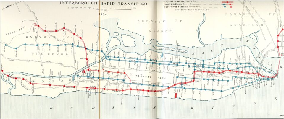
However, the neighborhoods that stuck out from the core were harder to serve. Hell’s Kitchen was a major transit desert due in part to its location between the working docks along the Hudson River and its proximity to Midtown. Most residents just walked to work. There was once an elevated train line along 9th Ave that served the neighborhood, but this was replaced with the subway along 8th Ave which was closer to the jobs in Midtown. The 7 train extension, an idea that had been kicking around since the 1960s, only reached the neighborhood in 2015.
Similarly, the Lower East Side sits in a strange area of the island, both near everything and somehow just out of reach. Like Hell’s Kitchen, the LES was once home to a north-south elevated train along 1st Ave. Demolition began in 1940 with the hopes that it would soon be replaced by a subway. Even the subways which were built are located further inland. This leaves residents that live closer to the geographic bulge along the East River a long walk or slow bus ride away from the subway.
What we in 2026 call the Lower East Side is actually a smaller geographic area than what previous generations understood it to be. Today, where real estate drives so much of how we live in this city, if you can carve out a new enclave, you can charge more for it. A century ago, the Lower East Side also contained what we today know as Two Bridges, Chinatown, Little Italy, NoLita, the East Village, and Stuyvesand Town-Peter Cooper Village.
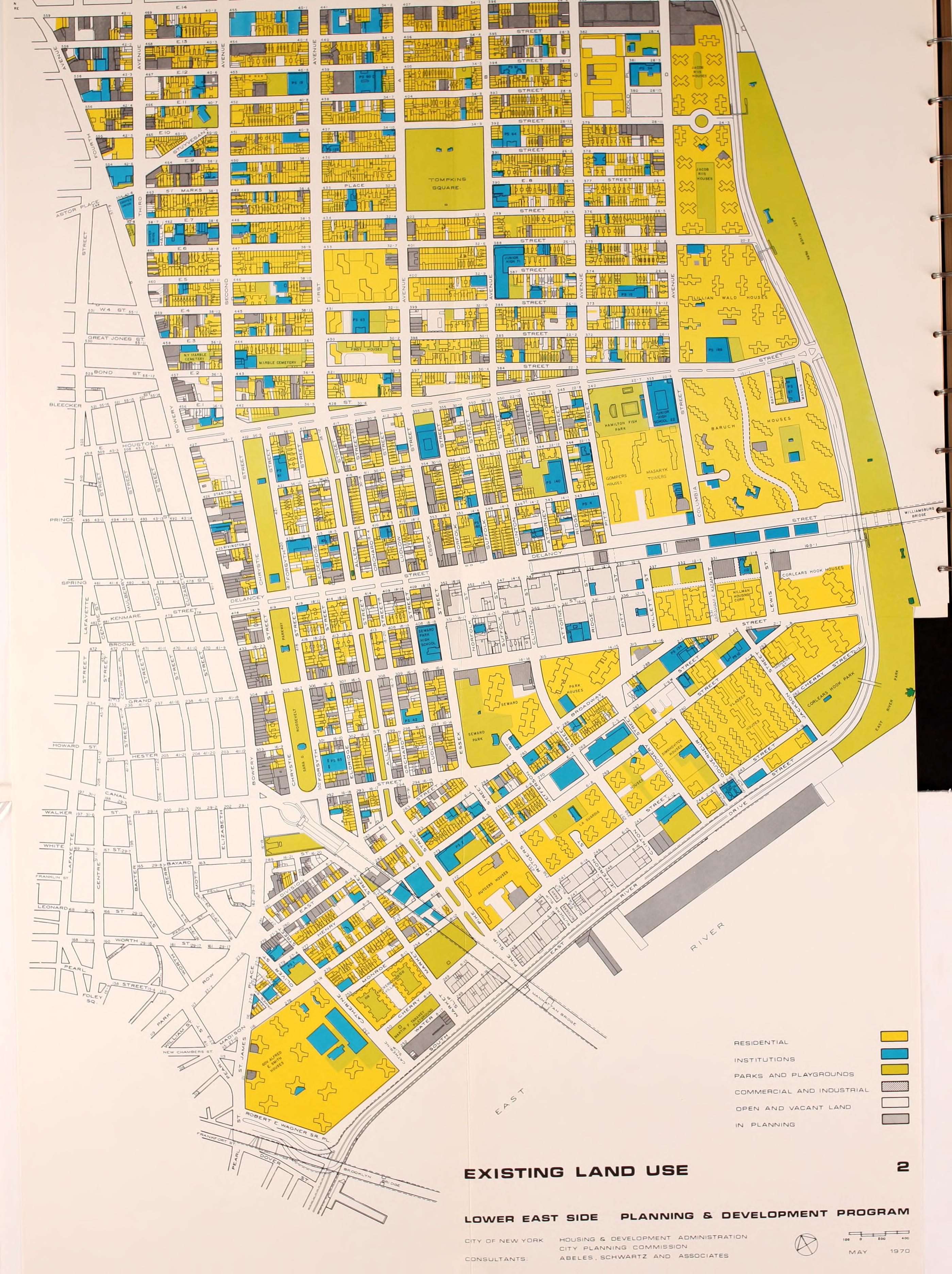
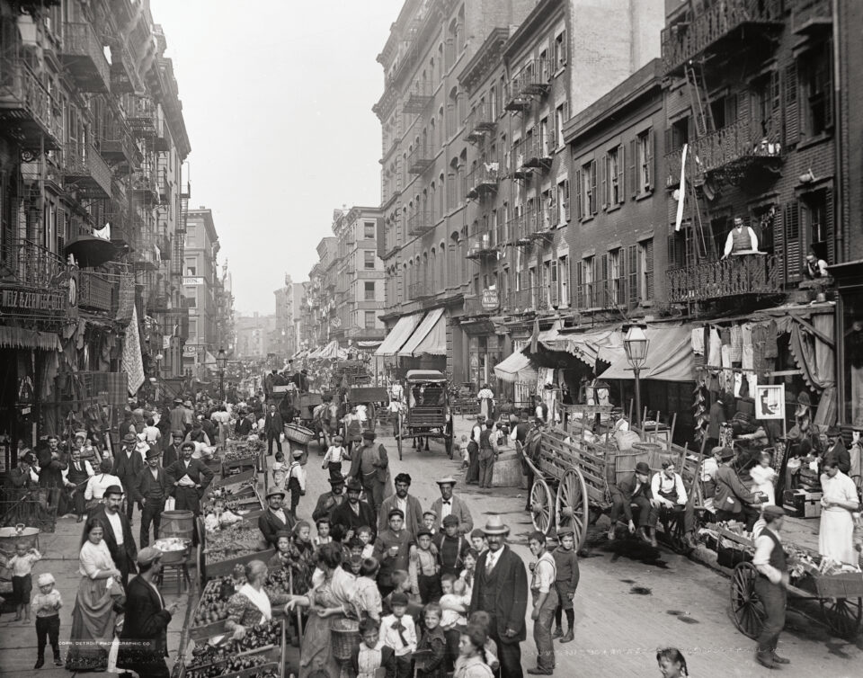
The Lower East Side, much like Hell’s Kitchen, was an historic dumping ground for the bottom rung of new immigrants to the city. The shipyards and other heavy manufacturing jobs that lined the river’s edges were where most of the new arrivals could begin their climb up the social ladder. With no money, and many of them with hungry families, living close to work was their only option.
This history explains why the area wasn’t directly served by the subways. If low-income people live close to their jobs, they have neither the funds nor the need to take the subway. In fact, the main goal of the early subways was to take people AWAY from areas like the Lower East Side. At the turn of the last century, the LES was one of the densest areas on the planet. The subways were a deliberate attempt to open up new, modern residential areas in the outer boroughs that would allow families to leave the squalid slums of the LES and commute to work.
One of the first subways that the city started to build after the success of the original IRT was the Centre St Line (the J/Z train today), an extension of the elevated trains coming off the Williamsburg Bridge to lower Manhattan. This new line was designed to serve the dense manufacturing district that was centered around the Bowery, allowing workers to move out of the slums and get to work quickly.
The Williamsburg and Manhattan Bridges allowed new subway lines to connect Manhattan and Brooklyn. But their majestic spans meant that areas closer to the waterfront would be passed over. Tunnels faced similar issues. When the 14th St-Canarsie Line, what is now the L train, opened, it featured stations at 3rd and 1st Aves where riders could connect to the elevated lines. But to get under the riverbed, the tunnels had to begin diving closer to the center of the island. This meant that a station at Ave C wasn’t feasible.
Early Attempts
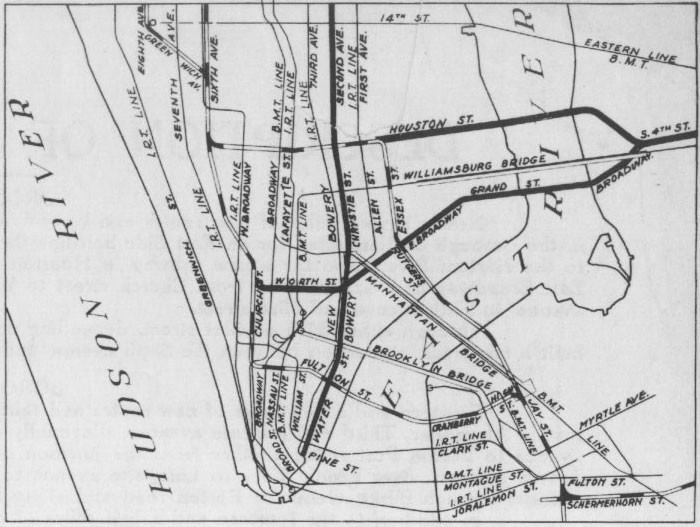
When the city took over planning and building the subways through the IND system, access to the LES was addressed. When the 6th Ave Line was first proposed in 1925, it proposed a new crosstown route along Houston St, turning south along Essex St before crossing into Brooklyn. This would provide a new station to serve the parts of the neighborhood under the Manhattan Bridge. Initially this was to be a 2-track line. As designs for the system grew, the line was expanded into a 4-track line. The additional tracks would be used for new line connecting to Williamsburg, Brooklyn.
Soon a second line was proposed through the LES. One branch would come off the 6th Ave Line at 2nd Ave and cross the river to Williamsburg along Houston St. The other would branch off the 8th Ave Line, running along Worth St, East Broadway, and then Grand St before crossing the river. These two branches would cover the gaps in service in the LES while also providing riders with direct access to Midtown. This part was seen as key to the success of the system, as building a north-south line through the LES would require unnecessary diversions.
IND Second System Plans
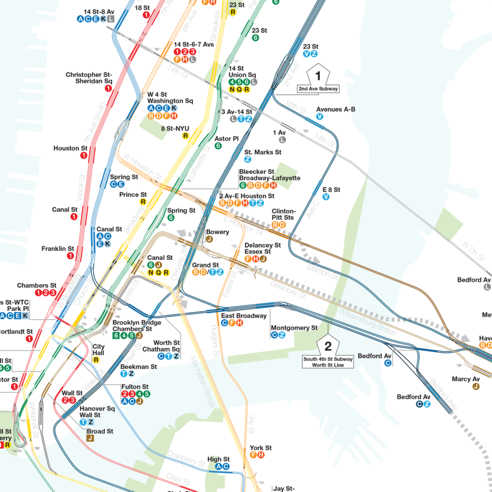
The 6th Ave and 8th Ave branches to Brooklyn (what was called the South 4th St Line) were only part of the ambitious expansion of the IND. The core of the second phase was the 2nd Ave Subway. A development boom had taken over the Bronx with the introduction of the IRT subways. The Lexington Line soon became overcrowded, and the city was eager to replace the 3rd Ave and 2nd Ave elevated trains with modern subways. The 2nd Ave Subway was to be designed with much higher capacity than previous IND lines. Planners calculated that 6-tracks would be needed to serve the Bronx. This capacity needed somewhere to go. While one branch between 6th Ave and 2nd Ave (originally planned along 61th St) was proposed, the remaining service needed an outlet further south.
Designs for the 2nd Ave Subway evolved throughout the 20th century and continue to evolve to this day, with focus shifting towards a western extension rather than a southern one. While a 6-track line could be justified north of 57th St, it was harder to justify south of there. Here, a standard 4-track trunk line would suffice. 2nd Avenue itself turns into Chrystie St when it hits East Houston St, and connections to the Brooklyn lines were important for the network. Planners came up with two schemes:
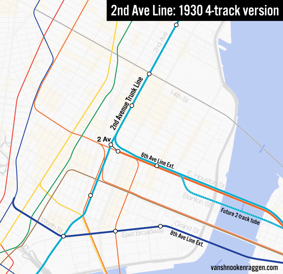
The 4-track scheme saw four tracks along 2nd Ave split at around 3rd St. Two tracks would continue south along Chrystie St, New Bowery (today, Pearl St) and Water St. An initial terminal would be located at Wall St, but a future phase would extend this into Brooklyn and along Fulton St. The second pair of tracks would turn east under 1st St and directly connect with the 6th Ave Line extension at a station located between Clinton St and Pitt St under East Houston St. This station was to be future-proofed so that if more service were needed in the future, the station could be expanded to allow for four tracks with a second river tube for 2nd Ave trains to be built along Stanton St to Brooklyn.
The 6-track scheme called for six tracks to be built from the Harlem River to 20th St. Here, two tracks would split off the main trunk and head east under 16th St with a station between Ave A and B (this was before Stuyvesant Town replaced the original street grid.) Then it would turn south along Ave C with a station at 8th St. When the branch reached East Houston St, it would connect directly to the 6th Ave Line extension heading into Brooklyn. Similar to the 4-track plan, the line would be future-proofed for an additional tunnel for 2nd Ave trains under Stanton St.
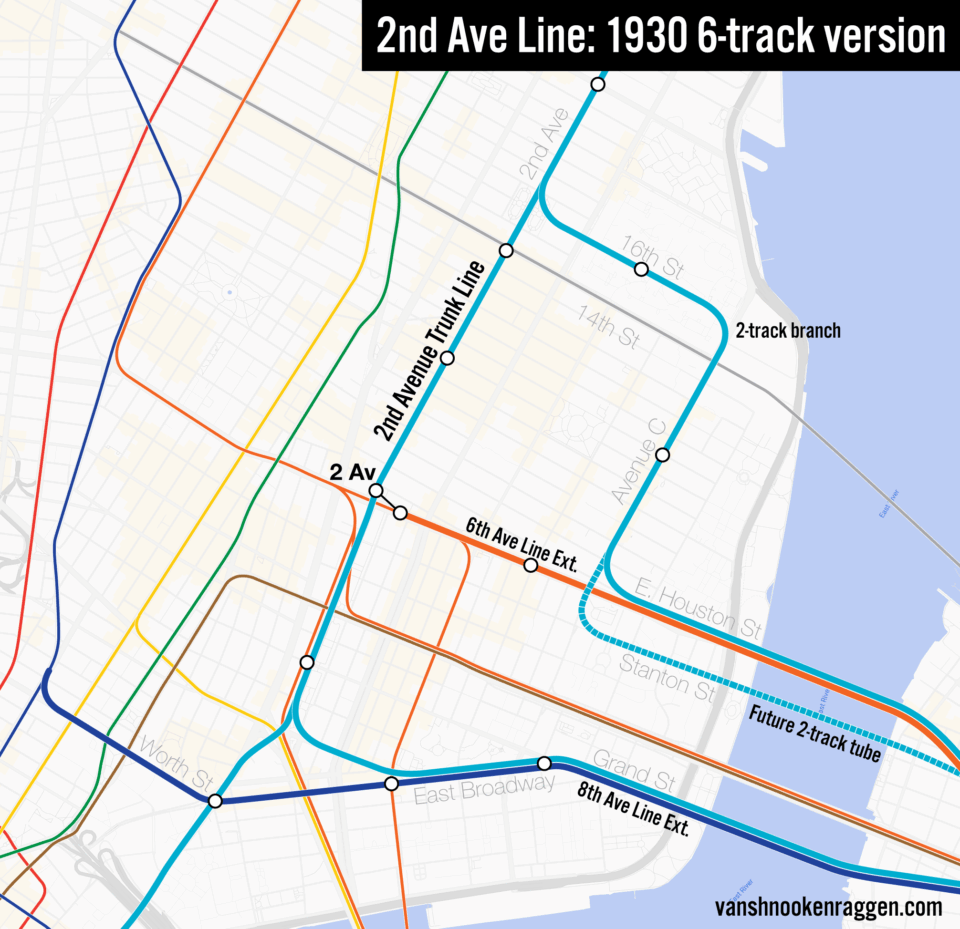
South of 16th St, the 4-track trunk 2nd Ave Subway would run to Canal St. Here, two tracks would head along New Bowery to Water St, while the other two would turn east and connect to the 8th Ave branch along Worth St and East Broadway. This, too, would be future-proofed to allow for an additional tunnel for 2nd Ave trains. Plans here called for an entirely new trunk line in Williamsburg that would turn south along Bedford Ave. Presumably, this line was designed to connect to the BMT Brighton Line or the IRT Nostrand Ave Line.
In 1940, the city was finally able to buy the bankrupt IRT and BMT subways. This changed how planners saw the system. Where before, all new lines had to be designed independently of others, now the IND and BMT could be connected. This opened the door to new possibilities and cheaper expansion plans. When World War 2 ended, the ambitious South 4th St Line in Williamsburg, which would have built two new lines through the LES, was dropped in favor of connecting the 6th Ave and 2nd Ave Subways to the Manhattan and Williamsburg Bridges. This provided more service between Brooklyn and Manhattan, but still left large areas of the waterfront with no service.
The Cuphandle
The LES was hit particularly hard by urban renewal efforts led by Robert Moses. Moses had begun his work in the 1930s, opening the East River Drive (now FDR Dr.) and East River Park. This cleared huge areas of the neighborhood that had previously been home to heavy manufacturing jobs. After the war, Moses moved thousands of families out to build massive Title 1 apartment towers and low-income NYCHA towers. His plans to permanently divide the neighborhood with a 6-lane expressway famously helped lead to his downfall.
After Moses’ defeat and ultimate removal from office, the Mayor John Lindsey and Gov Rockefeller began conceiving of a new way to revitalize the LES. Car-centric development and large-scale demolition were out, and mass transit with surgical development was in. The newly formed MTA took over from the bankrupt NYC Transit Authority, aiming to use Triboro Bridge and Tunnel Authority money to invest in new lines such as the 2nd Ave Subway.
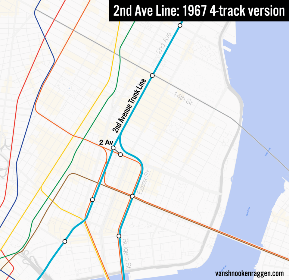
The MTA got right to work planning new lines. Many of the ideas had dusted off older proposals from a generation before. The initial plans for the 2nd Ave Subway picked up where they had been left, with six tracks. But this was soon pared down to four tracks. Two tracks would head to continue along Chrystie St and interface with the new station at Grand St, where the station was being built to allow the new tracks to be added on the outsides of the station envelope to create a cross-platform transfer. The other two tracks would need somewhere to go. Capacity in the Rutgers St Tunnel used by the F train remained unused. An initial plan from 1967-1968 called for a branch off the 2nd Ave Line to connect directly to the F train along Essex St. This idea didn’t seem to gain much support.
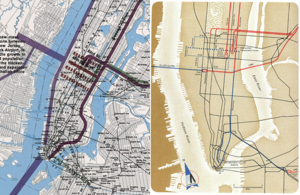
City planners (now separate from MTA planners) and local lawmakers pointed out that a line along 2nd Ave would leave large portions of the LES underserved. Some called for rerouting the line along Ave A or Ave C south of 14th St. This would allow for a direct transfer to the F train at Delancey St. But the MTA pushed back, saying that the diversion would add cost and travel time. The disconnect between the two plans can be seen in two maps from 1969. The MTA Program for Action map shows a simple line along 2nd Ave. The city released its own master plan that year, and in their section for mass transit, the 2nd Ave Subway makes a large bend through the LES, running along Ave C and then East Broadway before making its way to Water St.
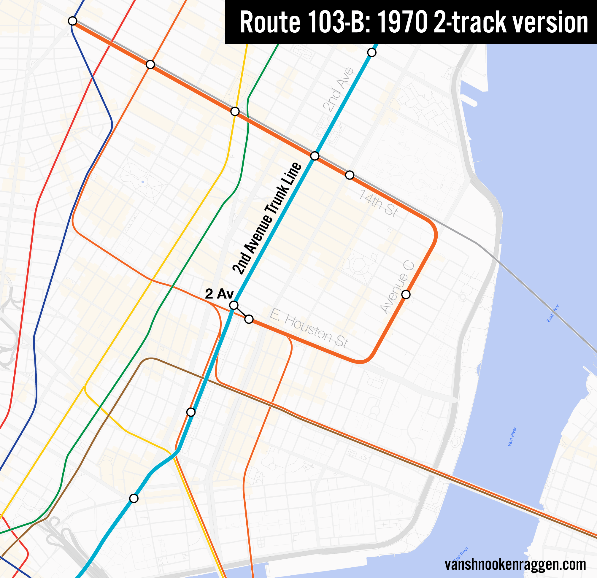
Due to the pressure, the MTA dusted off the Ave C branch idea from the 1930s. A branch of the 2nd Ave Subway would turn down 14th St and interface with the 1st Ave station. Similar to the concept for Grand St, the side platforms would have two new tracks built around them, allowing for a cross-platform transfer to 2nd Ave trains. The new line would then turn down Ave C with a station at 8th St.
But where to send the line after? The 1930s plans called for new lines to Brooklyn, but these had been long since discarded. The center tracks at the 2nd Ave station on East Houston St, built to be used for the discarded South 4th Line, were now seen as a convenient terminal. The 2nd Ave Subway branch would now form a loop through the East Village (a term that was now coming into vogue). This loop would become known as the cuphandle.
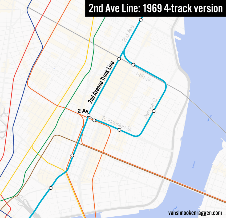
This wasn’t the only area where the MTA and city planners disagreed. The MTA initially wanted to build a 4-track line from the Harlem River to 34th St. As the true costs of the project became more clear, city planners called for cutting the entire line back to two tracks. The MTA’s focus was on providing faster service for Bronx riders. For a 2-track line to work, they wanted as few stations as possible. A first phase was proposed with stations at 125th St, 106th St, 86th St, 59th St, 48th St, and 34th St. Residents pushed back, demanding that more stations be added back to 72nd St, 96th St, 23rd St, and 14th St. A 2-track local line with additional stations increased travel time and reduced capacity. This meant that the branch along Ave C had to be rethought. There was no longer enough service from the main line and a branch.
While it may be difficult to imagine today, with packed L trains crossing the river every two minutes, the LL train of the late 1960s was greatly underutilized. The industrial decline of New York had hit Williamsburg especially hard, and much of the urban blight we associate with the South Bronx was also seen in Williamsburg and Bushwick at this time. At the time, there appeared to some to be enough extra capacity to shift the Ave C branch from the 2nd Ave Subway to the Canarsie Line.
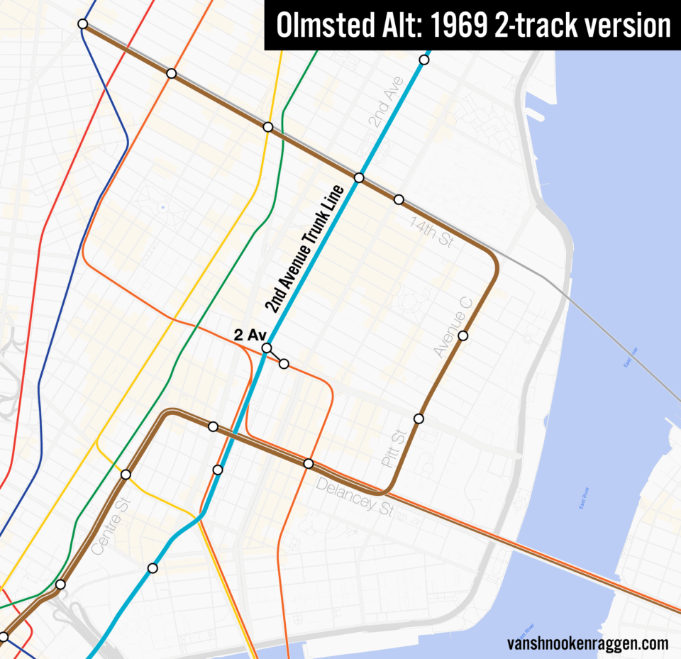
Two ideas were considered: the first was a simple branch off the L train along Ave C, connecting to the 6th Ave Line at the 2nd Ave station. The other was to continue the line south of East Houston St along Pitt St, then turn west under Delancey St where it would connect to the Essex St station. The station would be enlarged, and loop trains would continue along Centre St to Broad St. The first plan created a simple cuphandle shape, but the second one created a question mark shaped line. The cuphandle plan won out, due in part to the lower costs.
In late 1969, Route No. 103-B was officially unveiled. A 2-track branch off the L train would turn south along Ave C, then turn back west under East Houston St to terminate at the 2nd Ave station. Only one new station would be needed at 8th St. Two services were proposed: a 6th Ave service would run between Queens and the 2nd Ave station, then use the new line to loop up and back to 14th St to 8th Ave. At night, a shuttle between 2nd Ave and 8th Ave would run in its place. The Board of Estimate approved the plan in March 1970.
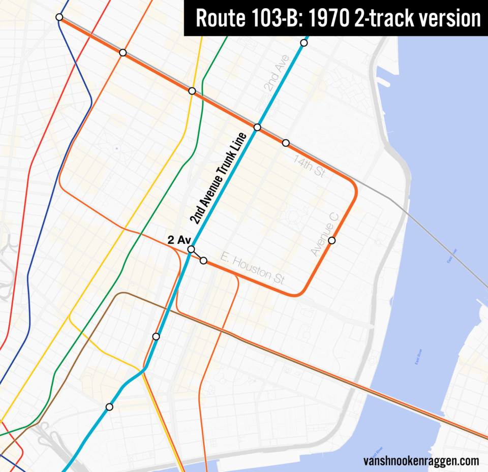
While the idea was popular with residents of the LES, its critics soon emerged. The Queens Borough President thought the projected $50 million (around $430 million in 2026) cost would be better used for a link to JFK Airport (Queens get the money, always.) In order for the tunnel to be built, large numbers of homes and businesses would need to be demolished at high costs. The one new station served a relatively low number of riders, especially for the cost. The convoluted service pattern seemed to suggest that the MTA wasn’t really serious about the plan to begin with, as they had been pressured to add the scheme to build enough support on the Board of Estimate to get funding for the larger Program for Action.
None of that would matter as the city began to fall off a financial cliff as soon as construction began. In lower Manhattan, work on 2nd Ave began at 9th St and under the new Confucius Plaza complex just south of the Manhattan Bridge. Work on the tunnel sections uptown progressed farther along by the time that the city cancelled the project in 1975. The tunnel at 9th St was filled back in, while the Confucius Plaza section was completed. No work on the Ave C line ever got past the drawing board.
Modern Plans
When development of the 2nd Ave Subway picked back up in the late 1990s, the line had been simplified to just an extension of the Broadway Line north of 63rd St. The 63rd St Tunnel had limped along in the 1970s and 80s due to funding problems. The 63rd St Tunnel had built a fully operational extension of the Broadway Line express tracks to Lexington Ave, but this was only used to store trains. The northern extension along 2nd Ave served to decongest the 6 train on Lexington Ave. In the MTA’s eyes, there was less of a need for a subway along 2nd Ave south of 63rd St, as most of the office jobs were located west of 2nd Ave.
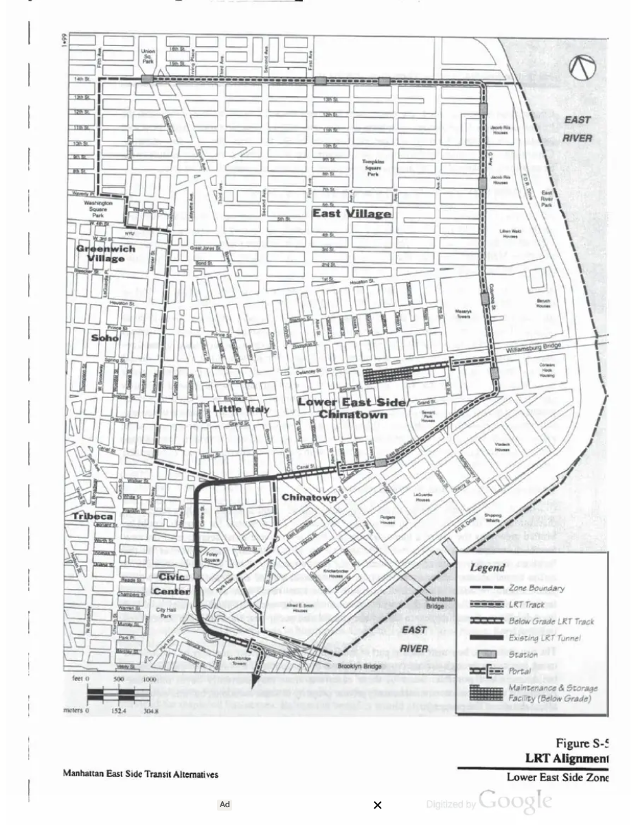
The MTA considered a number of alternatives for serving lower Manhattan. Outlined in the Manhattan East Side Transit Alternatives report, the MTA proposed a light rail loop food the LES. Light rail transit (LRT) vehicles would start at Union Sq, running on tracks in the street along 14th St to Ave D. The line would turn down Ave D and run to Grand St, where it would turn west along East Broadway, then to Canal St. Near Canal St and Allen St, the tracks would descend underground to link up with the disused Centre St loop tracks. These tracks once connected the Manhattan Bridge to Chambers St, and were taken out of service when the Christie St Connection rerouted service over the bridge to 6th Ave.
The LRT line would use the subway tracks to reach Chambers St, where a new ramp would be built to allow trains to fly over the J train tracks and reach a new portal next to the Brooklyn Bridge, allowing trains to reach street level at Pearl St. This ramp partially exists, as it was built for elevated trains crossing the Brooklyn Bridge to reach the new subway. When it was deemed impractical, the plan was scrapped, but not after parts of the Chambers St station were built with the ramp in mind. LRT trains would continue along the street south to Broad St. It was proposed to use the abandoned trolley terminal at Delancey St for storage and maintenance.
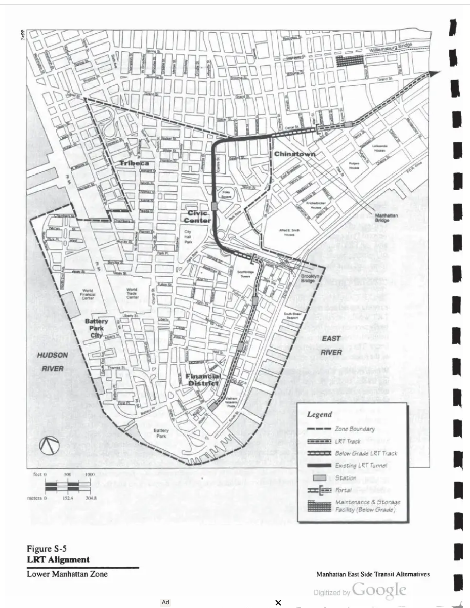
This irked Speaker of the NYS Assembly Sheldon Silver, the assemblyman for the LES. As a young man growing up on the LES he remembered the MTA promising to bring 2nd Ave to his neighborhood, seeing his streets ripped up for nothing. He would support the 2nd Ave Line only if the MTA extended it all the way downtown. The MTA added back the section of subway south of 63rd St to gain Silver’s support. Plans for light rail were dropped, though how serious they were in the first place is unknown.
While a strong advocate for the 2nd Ave Line, Silver was also corrupt. In 2015 he was indicted on charges of extortion, wire fraud, and mail fraud. A year later he was found guilty and sentenced to concurrent 12-year and 10-year prison terms. When the first phase of the 2nd Ave Line opened in 2017, Silver was behind bars. He would spend the rest of his life there, dying in 2022.
As Phase 2 of the line was getting final approvals, the MTA proposed continuing the extension west along 125th St to Broadway. This idea has picked up support from Gov. Hochul. There has been no strong advocate for extending the 2nd Ave Line further south.
Conclusion
Without a doubt, the Ave C cuphandle is one of the strangest official proposals ever put forth for the NYC subway. Subways are very effective for moving large numbers of riders long distances. But they are expensive to build. Building a glorified shuttle through a neighborhood, even one as dense as the LES, really makes no practical sense. If the city had moved forward with the South 4th St Lines, more of the neighborhood would be served by stations that could justify their expense because the lines had larger service areas.
The light rail plan is certainly fun to think about. No doubt, this came about when the federal government was funding LRT systems around the country in the 1990s and the MTA figured they might try to get funding. Today, bus lanes provide riders a faster ride for far less cost to the MTA.
As the MTA has shifted focus to extending the 2nd Ave Subway to West Harlem, any plans for extending it south of 63rd St will be kicked down the road for another decade at least. Should the time come when the MTA refocuses to serving the LES, I have no doubt there will be calls for new loop lines to reach waterfront residents.
Gallery and Acknowledgement
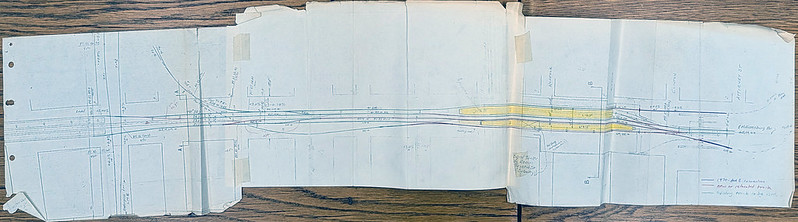
The bulk of knowledge for this post came from the Robert Olmsted archive at City College of NYC. Here are the original documents I found in the archive.


Olmsted’s Centre St Loop alternative

Great article! A fascinating dive into a rarely covered subject.
Two related thoughts come to mind.
In Philip Plotch’s book “Last Subway “ about the history of the Second Avenue Subway, he describes how MTA planning staff argued with Chairman William Ronan against the idea of whole idea of the cuphandle. It’s interesting to read in your article about the parallel efforts by the planners to come up with the best version of a Lower East Side cuphandle that their skills could devise, even while they may also have been cautioning executive management about some of the underlying drawbacks of the overall concept.
Your article also speaks to the considerable challenges of serving residents living near the waterfront of Manhattan’s Lower East Side “bulge”. I would suggest that one thing that has changed about the local transportation landscape in recent years is the introduction of ferry service to the area, with landings at Corlears Hook and Stuyvesant Cove.
I very much realize that ferries are not the subway. They cannot provide the same level and type of service that a train, or even a bus route, can offer. They can, however, present waterfront communities with certain travel opportunities that land-based transit cannot. NYC Ferry is not by any means the NYC Subway, but a resident living within walking distance of those ferry landings now has the option – depending on the landing – of a one-seat ride to destinations including Wall Street, E. 34th Street, Atlantic Avenue, Red Hook, E 90th Street, Soundview, Throgs Neck, Brooklyn Army Terminal, and Rockaway, and via transfer to many more locations including LIC, Astoria, Williamsburg, Greenpoint, and St. George. Again, this is may not be the subway, but it certainly is far more than was available to the LES waterfront less than a decade ago.
Thank you so much for this article.
I’m glad they explored the options. It’s always good to have some real data to back up why an idea is bad. Honestly, I had never considered writing about this project because I knew planners weren’t that serious about it. But there was more to it than that!
I didn’t write about the ferries, but you are right. Ferries and buses are good options for hard to reach places. Heavy rail mass transit is good for long distances. A good transportation network needs both to work.
As always, thank you Alan!
Thought I remembered high-water-table being one of the limiting factors on C and D below 14th, but can’t cite a source. That part of the neighborhood suffered during Sandy, with basement apartments and stores flooding.
A large chunk of upper Alphabet City is built on filled-in land, so your instinct isn’t wrong. I considered writing about it, but I don’t think it really mattered when no one was all that serious about it in the first place.
Interesting! I want to see this built, but I was wondering how the tracks are going to be laid out in order for this to work? Will they stack over each other, or be on the same level?
Question Mr. Lynch – what would be your preferred way of pulling off serving the Lower East Side, both on the north-south (lets say Ave A, B, or C) and east west axes? Assuming we managed to get transit building costs down and some actual funding?
The option I have in mind is a combination (If 4 track 2nd ave line, divert two tracks toward avenue C and then take over the Center St. Subway + 8th Ave + Worth Street Line to Utica), but I’m curious how you would handle it.
I don’t see a 4-track 2nd Ave Line ever happening. But I also don’t think that’s necessary. As lower Manhattan has shifted away from commercial use and evolved into a more residential area, the need for express service from the Bronx and Queens to Wall St has relaxed. I’m not even sure you would need a full 30tph 2nd Ave Line to serve Wall St at this point.
While I don’t think it’s necessary any time soon, my solution would be to build a new tunnel along E Houston St to Williamsburg as part of either a full Utica Ave Line or replacement of the Jamaica El. The M would be rerouted through the new tunnel, and you could send a branch of the 2nd Ave Line through there as well. This would add a station between Ave B and C. But like I said, this isn’t a priority anytime soon.
I think the original IND plan, which you reference, is and will always be overkill. There just isn’t that much traffic coming from northern Brooklyn into lower Manhattan. Building a BRT loop along East Broadway, Pitt St, and Ave C really would be the best short to medium term solution. Long term is probably too far out to think about.
Thanks for this very interesting article. The idea of having dedicated subway service go through the Lower East Side only to access trunk lines in Manhattan didn’t make sense to me. This is where you would expect buses to serve this purpose, except for the congestion problems that make it difficult. Anyway, this historical look at how these ideas have evolved over the past century is fascinating!
Even with the solid buses in the area this would be a good plan as someone who is in this area every time I return to NYC and also just knows the ins and outs of the area, the 2nd Ave subway running to Alphabet City would be a great appreciated extension. I personally like JTAS plan where it runs via Alphabet City via Ave B or C then has a stop at Houston Street, then Uses the other 2 tracks of the Nassau Street Line to go to Broad Street then J and Z trains would be permanently at Chambers Street or even take over R trains to Bay Ridge and either R trains run via a New Tunnel to Fulton or the R terminates at City Hall for Good and maybe the E and K trains take over and run to Fulton (this is assuming 2nd Ave doesn’t go to Fulton) If 2nd Ave takes over both Fulton and 4th Ave then E and K trains would most likely be rerouted to Culver Via a New tunnel and most likely one of the trains split off before reaching Culver and run to Red Hook.