
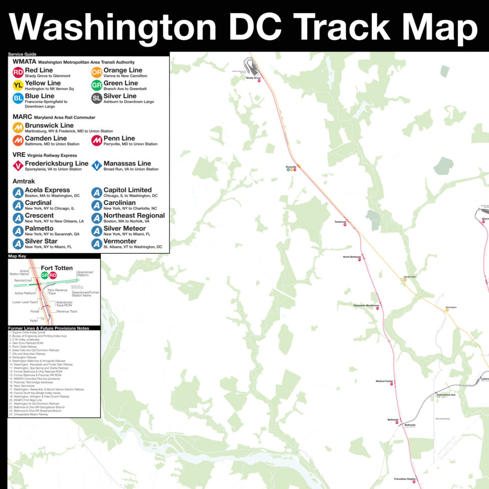
The history of the Washington, DC Metro, run by the Washington Metropolitan Area Transit Authority, is one of the more fascinating American urban tales. Like so many growing cities after World War II, a large-scale highway network was planned for the city. Unlike most other cities, much of this network was rejected in favor of a new metro system. DC, like San Francisco and Boston, chose to go another way and in doing so, created one of the best examples of metro design and architecture in the world.
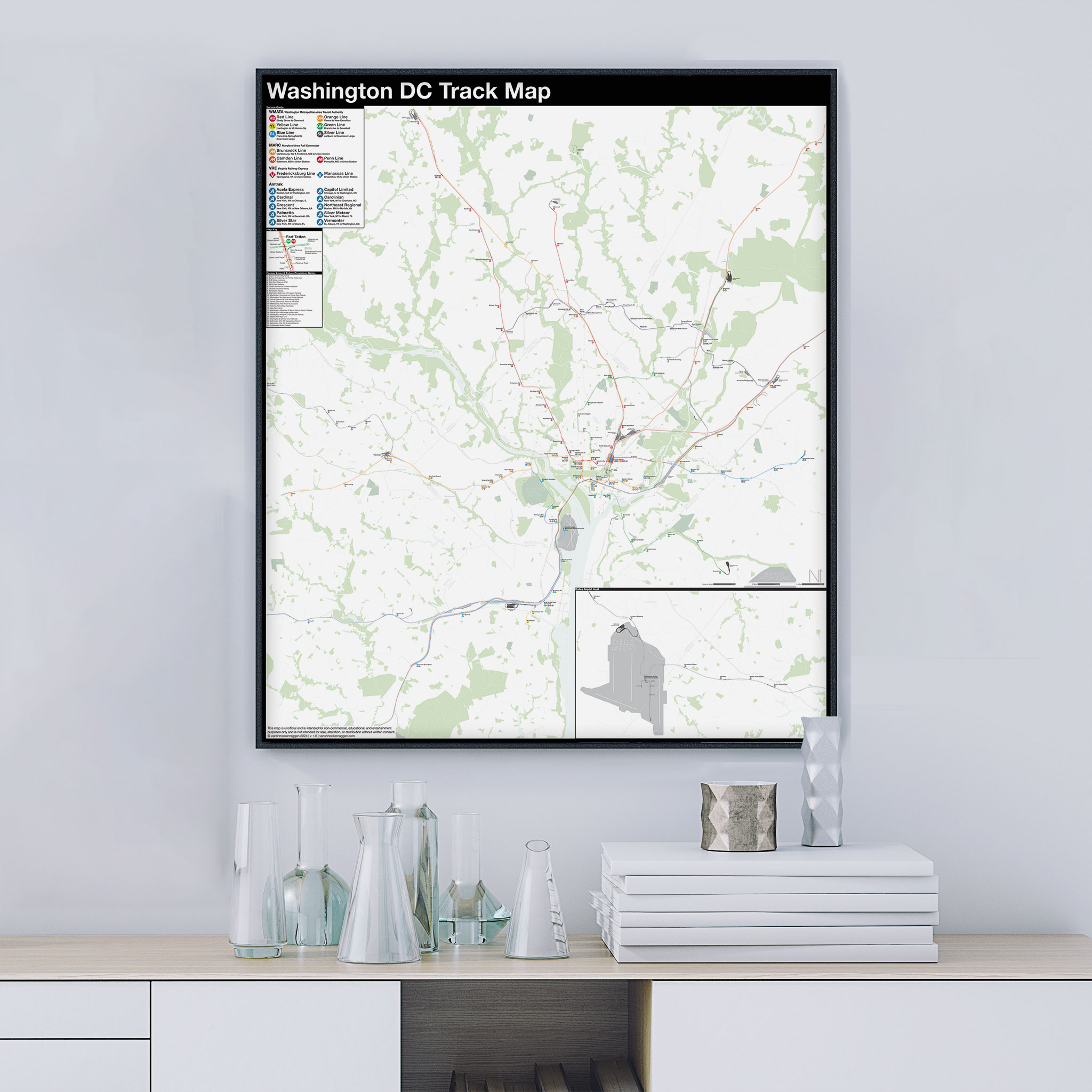
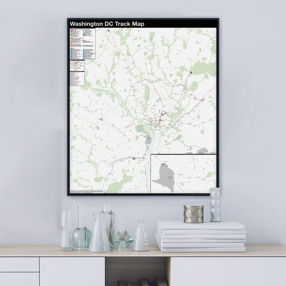
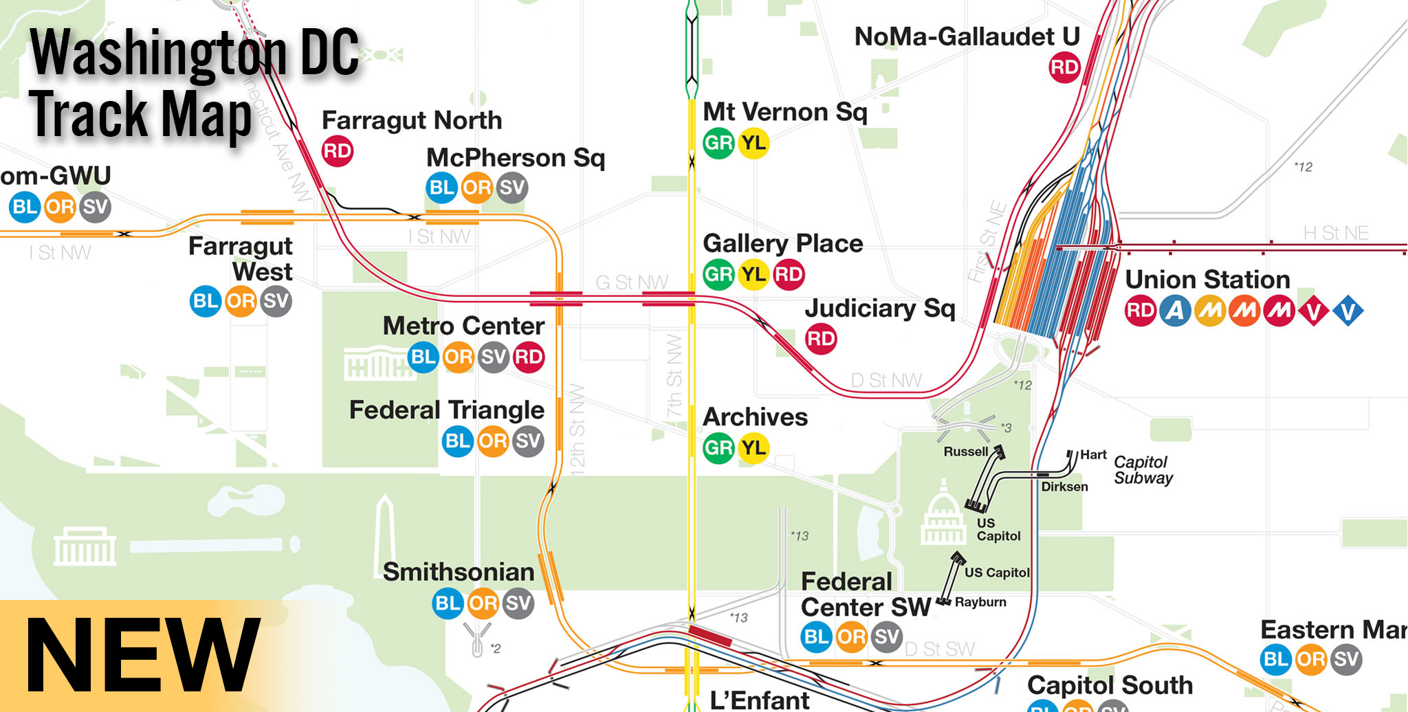
The Washington DC Track Map is not only the WMATA system, but also shows the other rail lines that serve the nation’s capital. These include MARC and VRE commuter trains, Amtrak, current and former streetcar lines, the future Purple Line in the suburbs of Maryland, and even lesser known transit lines like the Capitol Subway and AeroTrain people movers.
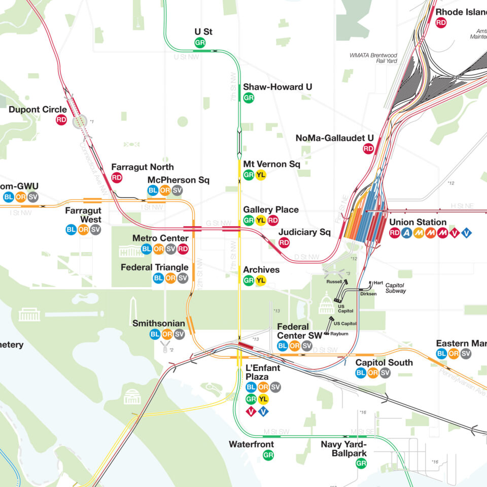
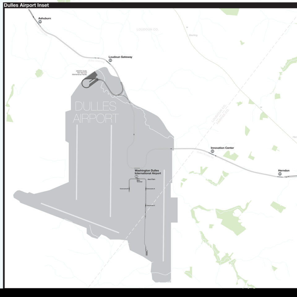
I’ve made two new design choices with this map that slightly differ from my previous maps. First, there is a large inset map showing the Silver Line extension and Dulles Airport. This was done to save on space when the map is printed (no use is charging for empty paper!) Second are former streetcar lines in central DC. Because of the cramped space and the fact that much of the DC Metro was built directly below former streetcar lines, I’ve decided to put these lines on a lower level (two-dimensionally speaking) so not to obscure the active Metro lines.
The DC Metro was designed as a hybrid system. In the central city, stops were spaced close together, while in the suburbs they were spaced further apart. Suburban stations often include large park-and-rides. While these were staples of post-War metro systems, they have fallen out of fashion today. DC is now going gangbusters with transit-oriented-development (TOD) around suburban stations. The Silver Line, the most recent extension to the system, was partially funded with bonds based off of future TOD growth. This should be an example other cities follow.

Hi there! I’m not sure if you remember, but I once emailed you my own track map made in ArcGIS for the Washington Metro, and now I see that you have made your own which i’m incredibly happy about, as your work has inspired me to pursue a minor in GIS and make some of my own track maps. I feel like it’s all come full circle 🙂
I love this map, and have some notes about the map to make it even better:
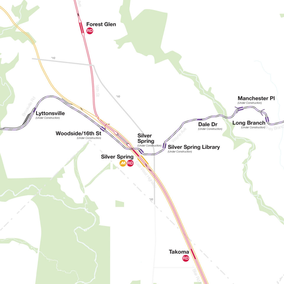
– The Purple Line will be underground at Bethesda, the tunnel portal should be near Pearl Street.
– The Purple Line station is called 16th Street-Woodside as opposed to Woodside/16th Street
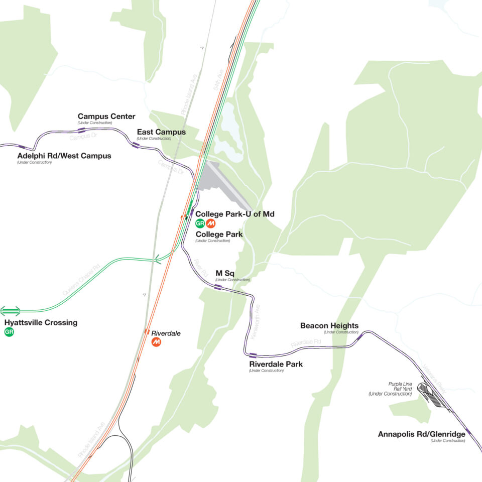
– The Purple Line stations around UMD and east are slightly mistaken in terms of name. From west to east, the stations of concern are are: Adelphi Road-UMGC-UMD (instead of Adelphi Road-West Campus), Campus Drive-UMD (instead of Campus Center), Baltimore Avenue-UMD (instead of East Campus), Riverdale Park North-UMD (instead of M Sq), Riverdale Park-Kenilworth (instead of Riverdale Park), Beacon Heights-East Pines (instead of Beacon Heights), and Glenridge (instead of Annapolis Road-Glenridge).
– Laurel Park on the MARC Camden Line should be Laurel Race Track (it’s written as both two words and one word officially so you can choose haha).
– I believe at NoMa-Gallaudet U, there should be only one abandoned Metro track instead of two (as they shifted the alignment so that the former southbound track became the northbound track, and they built an entirely new southbound track).
– There’s a planned extension of the DC Streetcar east of Oklahoma Avenue all the way to the Benning Road Metro station with official routing and even some track diagrams, although this project keeps getting delayed so I can understand why you wouldn’t want it on the map since construction hasn’t started yet, but you can find renderings of what it’s supposed to look like online.
– There’s a missing tunnel portal on the BL/YL lines north of Braddock Road. It’s around Nelson Avenue and Main Line Boulevard.
– There’s two missing tunnel portals between Addison Rd and Morgan Blvd (it’s a super brief exposed section close to Central Ave & Jonquil Ave).
– The pocket track at Mount Vernon Square should be colored yellow since the YL uses that to turn around and head back towards Huntington.
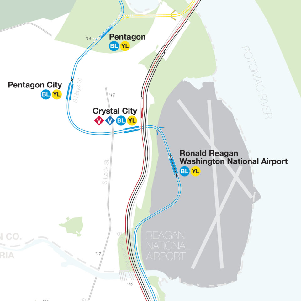
– At Huntington, the tail tracks just south of the platform should have a tunnel portal as they actually go into a mountain (there’s also a cool inclined elevator at that station haha).
– I actually never was able to figure this out for myself so I recommend double checking this, but I believe the GR tracks are actually stacked on top of each other from Georgia Ave-Petworth to Columbia Heights.
– The Dulles Rail Yard is not on Dulles Airport property, it’s just outside of it.
– The Silver Line’s bullet abbreviation is incorrectly labelled as SL instead of SV in the legend.
– It might be worth putting a note at VA-267 & the Trap Road overpass about the cancelled Wolf Trap Metro station on the Silver Line. There’s even an unused station code for it (N05). There’s a similar cancelled station called Quaker Lane on the Blue Line right next to the Alexandria Yard near South Quaker Lane as it terminates near the tracks. It also has an unused station code (J01).
– There are two “secret” platforms at Brentwood Yard and Alexandria Yard that are extremely short and meant for operators to get on and off the train to begin/end shifts (they’re not that secret, the train stops there sometimes even in revenue service).
– There are abandoned streetcar tracks on P Street NW just west of Wisconsin Avenue (in Georgetown) embedded in the ground that are not present on the map (this is visible on Google Street View).
Thank you so much for making this map, this made my day, and I hope these comments are helpful to you as well!
Max! Thank you so much for this great feedback. I just went back and found your track map. I wish I had remembered this when I was making mine, but now I’ve got it saved.
Can you write an article about why the MTA should add express platforms at 51st street (Lexington Avenue)? It would be easier than when they added express platforms at 59th street under NRW, because they wouldn’t have to dig all the way down. It would benefit riders as 51st has more ridership than 59th. In addition, it would prevent people from taking the already overcrowded 6 one stop to transfer to 45 at 59th/42nd.