
If you are reading this blog it’s probably because you have an interest in subways and maps (I can’t imagine any other reason to be here since I stopped posting music recommendations a decade ago.) If you aren’t familiar with him, Peter Lloyd is an author and map nut who has a fantastic blog looking into the evolution of the designs for the New York subway map., http://nycsubwaymap.org/
Peter has been posting a number of amazing finds on Twitter recently, specifically about the work of Arthur Weindorf. From the New York Historical Society website:
Born in Long Island City, Arthur Weindorf (1885- 1979)was a practicing cartoonist in his early years. From 1908 to 1944 he worked as an architectural designer and engineer for the City of New York’s Public Service Commission (the precursor to today’s New York City Transit Authority.) During his tenure at the Public Service Commission, Weindorf collected drawings, clippings, maps, posters, and photographs of the New York City subway. In 1916 he built the first New York City subway model; his later models were displayed at the 1939-40 World’s Fair. In addition to models, Weindorf also created illustrations, maps, certificates, and paintings for the Commission. Weindorf’s non-subway-related artistic work was widely exhibited during his lifetime.
Guide to the Arthur Weindorf Subway Collection
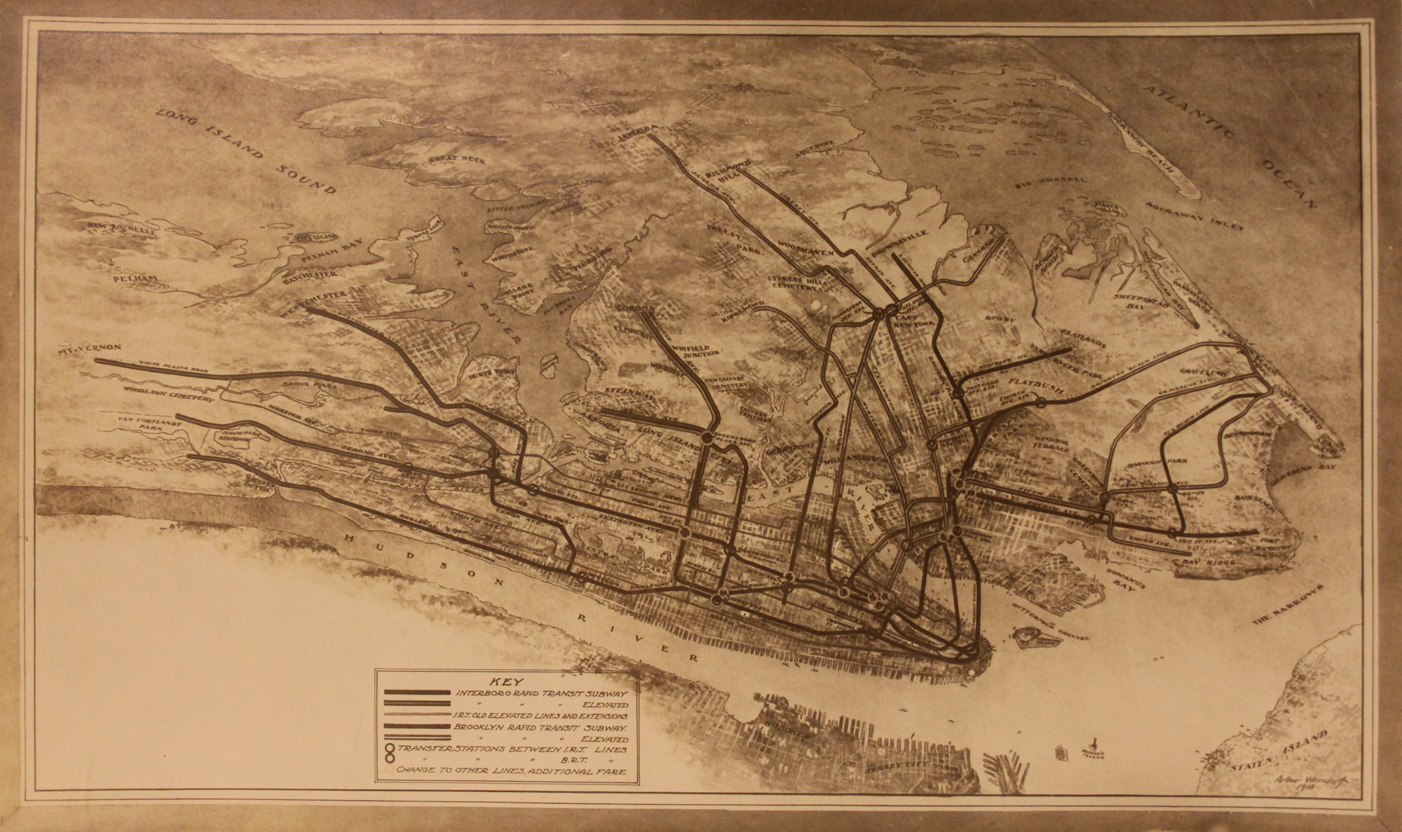
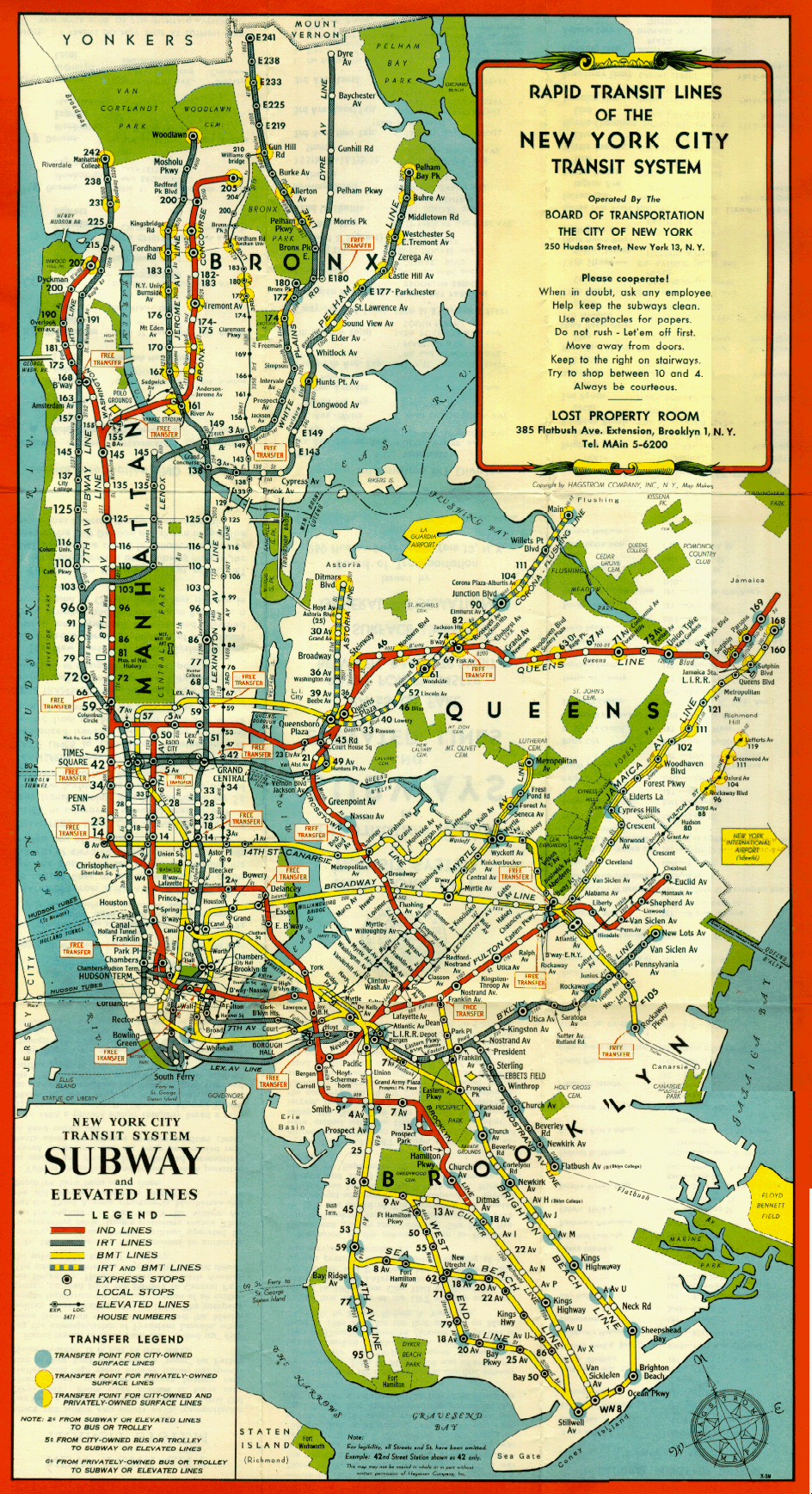
Because of Weindorf’s tenure making maps of the subway during the birth and construction of the IND, the Independent City-Owned Subway, we can use his maps as a guide through the development of the system. What became the IND was originally the next phase of subway expansion after the construction of the Dual Contracts, an agreement between the city and the two private transit companies to divide the expansion. The next phase would have most likely created a second Dual Contracts, so these two networks could expand. But Mayor John Hylan had other plans.
I absolutely love this map because it’s the only rendering of what the original two systems, the IRT and BMT, would have looked like had the IND not been built. Of these proposals, only the extension of the IRT Flushing Line was ever built as-proposed. What today is the G train, the Crosstown Line, would have been built as part of the BMT to connect the Queensboro Plaza station to the Brighton Beach Line (I covered this in a previous post.)

The most interesting part of this proposal is the first draft of the 8th Ave Line, which would be slightly different than it is today. Built in stages, the first phase would have connected the 7 train to the L train under 8th Ave, creating a loop. (I guess the L platforms would have been widened to account for the more narrow IRT trains.) The first phase would be 4-tracks from 41st St to 14th St. Phase 2 would extend 2-tracks south to Chambers St, Phase 3 would build 4-tracks north of 41st to 155th and 3-tracks north to 181st. The tunnel was to be bi-level and built on one side of 8th Ave so that, in the future, another 4-track tunnel can be added!
At 57th St, the 8th Ave Line shifted to Amsterdam Av. It was also proposed to break off the IRT Lenox Ave Line from the 7th Ave-Broadway Line and connect it to the new 8th Ave Line to provide more express service on the IRT. Instead of replacing the 6 Av El with a subway, the northern extension of the BMT Broadway Line would have sufficed. The express tracks were to be extended along Central Park West and then under Adam Clayton Blvd to 155th St. Provisions for this extension were built, but ultimately used for the 63rd St Tunnel and 2nd Ave Subway.
The Staten Island Tunnel was still on the drawing boards here. While provisions for this tunnel were built into the 4th Ave Line at 59th St, planners preferred extending the line from Bay Ridge instead as it would allow for more capacity.
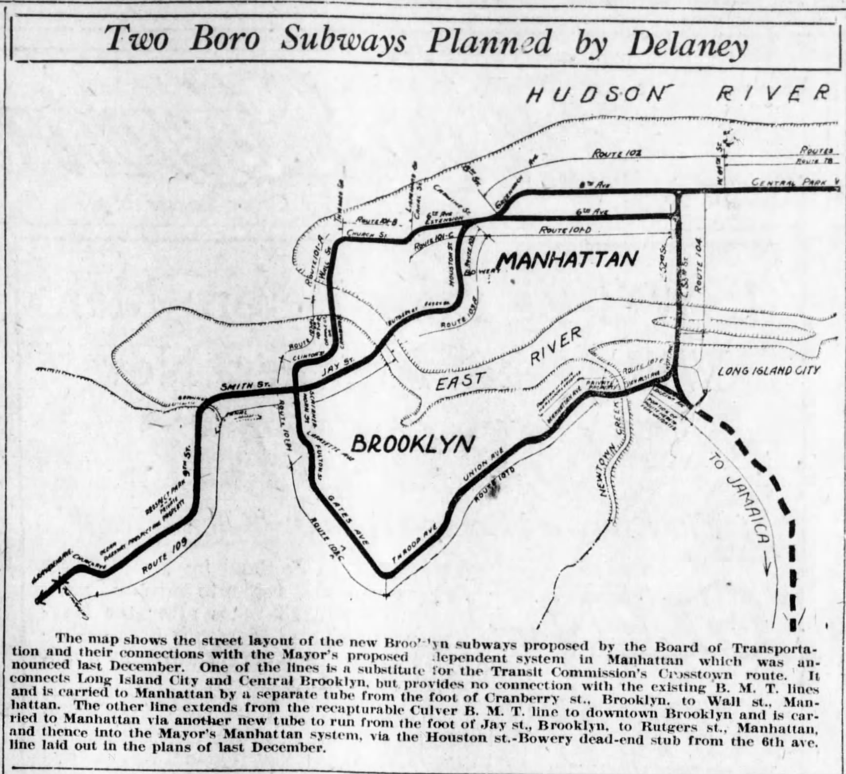
The last piece was a new East River tunnel connecting the lower level of City Hall station (Broadway Line) with the Fulton St El in Brooklyn. The proposed Ashland Pl connection (between the Fulton St El and DeKalb Av station) was cut due to lack of capacity, so this new tunnel would solve that. The Fulton St El was to tunnel at Clermont Ave, run up to DeKalb Ave and then along Livingston St. One alternative went across to Broad St and the other went up to the Brooklyn Bridge and then across in a tunnel. A round about way, but you can see how this evolved into the Cranberry St Tubes into the IND Fulton Line.
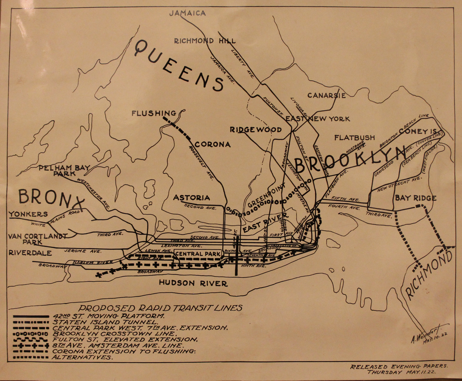
Mayor Hylan famously hated the private companies and wanted to drive them out of business so that the city could control its own transit. To do this, he took these plans and created the Independent System, IND. Here, 3 years after the initial plans were announced, we can see how the IND evolved the plans to create the system we know today. The original alignment of the Cranberry St Tubes (A/C trains) under Clinton St is still here, and what is today the G train would have originally run into Manhattan along 8th or 6th Aves.
Weindorf spend the next decade creating easy to read maps for the ever expanding system. He experimented with different styles. The first just showed the entire system with single lines, only showing the local and express stations (along with landmarks and transfer points.)
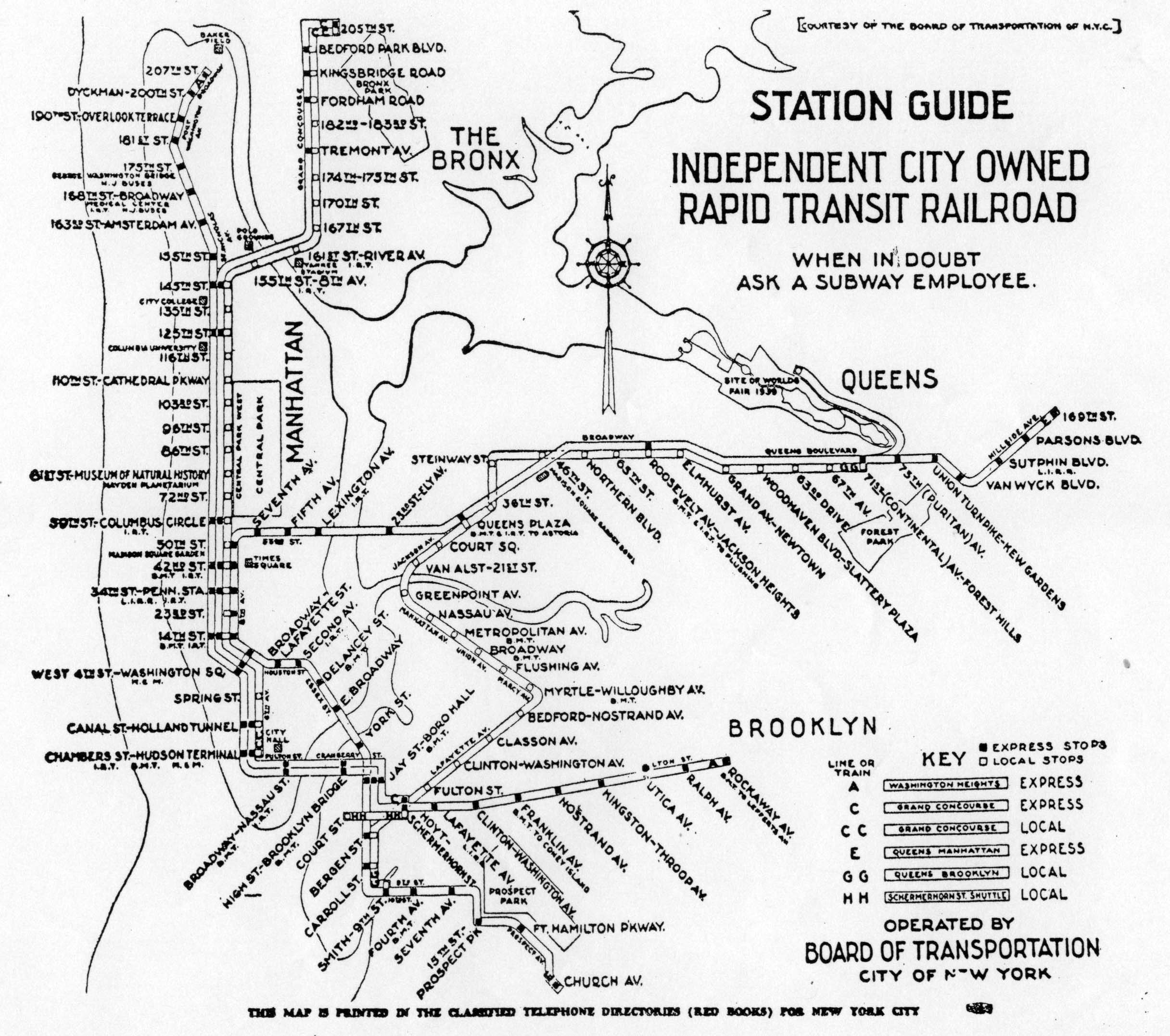
Later, as the IND began to run more complex service, he experimented with one of the first service guide maps to show each train individually. This style would be infamously expanded upon by Massimo Vignelli decades later. But at the time, the subway maps only showed single trunk lines and branches (as they still do today.) The lines weren’t even color coded, rather, a mapmaker like Hangstrom color coded each system instead.
As the system became more complex, the maps had to evolve.
When the subways were consolidated under the NYC Board of Transportation in 1940, the need for individual system maps was gone. What was needed was for a unified map. Weindord had originally made maps like this in the late 1910s, but his style had evolved. The full city maps of Hangstrom won out. It wouldn’t be until 1972 when the Vignelli map was released where we would have a subway map that showed individual routes.
Following along with Peter Lloyd, German cartographer Chris Neuherz came up with a modern version of the 1939 service guide (before the 6th Ave Line opened.)
This got me to thinking about an alternative future might have been where the IND was successful in building out much of their Second System. The plans for the Second System evolved much through the 1930s as the financial realities of building such an ambitious railroad sobered up planners.
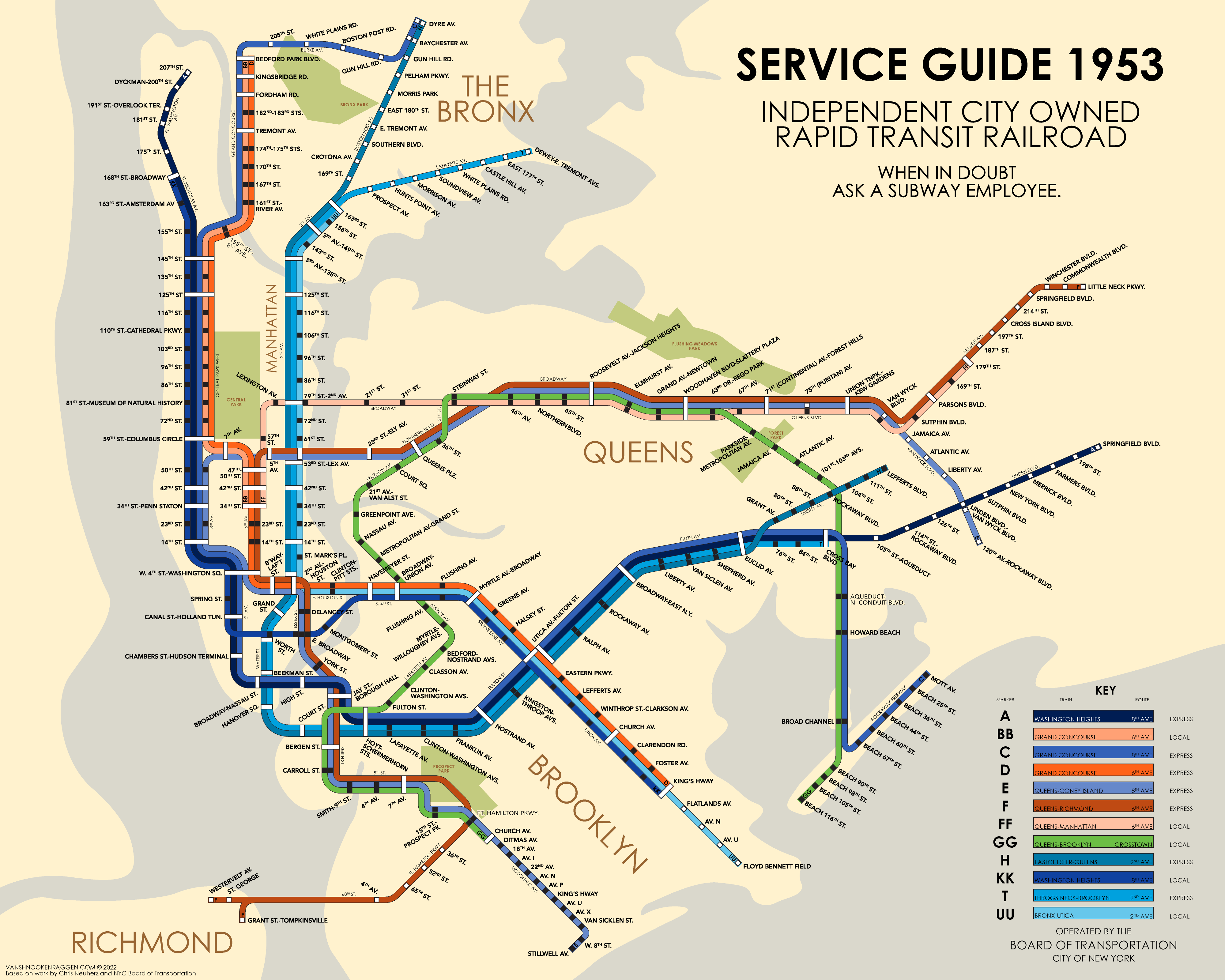
Jumping off of Chris’s map and being inspired by the 1940/42 Weindorf maps, I wanted to create a version of the system as it could have been had Robert Moses not had his way with the city. The map is based off of the 1939 IND Second System Map and makes a few assumptions. I’ve covered these past proposals more in depth in my IND Second System Track Map, but here I wanted to keep things simple and more realistic.
The main differences between the 1929 and 1939 plans are the loss of the Myrtle-Rockaway Line, a branch off the South 4th-Utica Line with connections to the Crosstown Line and the Queens Blvd Line via the Winfield Spur. The Winfield Spur was probably not a serious proposal, one added purely to gain political support for the overall plan. By ’39, the Rockaway Line had been relegated to a branch off of the Queens Blvd Line. The Worth St Line, a branch off of the 8th Ave Line, was intended to serve the Myrtle-Rockaway Line, but with that removed, the need for the Worth St Line as part of the South 4th St Line is reduced.
Plans for the 2nd Ave Subway also varied throughout the decades. At one point the line was intended to have 6-tracks and a number of branches. I’ve always found it interesting that, despite all the different alternatives, the 1939 Second System map only shows 2nd Ave as a single line running to Throgs Neck. For my map, I assumed that the 2nd Ave Line was built with 4-tracks, with the express tracks connecting to the IND Fulton St Line at Court St, and the local tracks branching off to connect to the South 4th St Line to act as the express train on the Utica Ave Line (as planned.)
In the Bronx, I assume the local tracks would terminate somewhere in the south Bronx, as the local tracks on the 8th Ave Line terminate at 168th St. The express tracks would split with a new line running along Lafayette Ave to Throgs Neck and the other taking over the Dyre Ave Line.
If you follow me on Twitter or Instagram, you may have seen this map titled “Station Guide 1949”. I decided to change this to “Service Guide 1953”, adding 4 more years to buy this fictional IND more time for construction. The original IND took 16 years (and $17 billion adjusted for inflation) to build out. The Second System, especially the 2nd Ave and Utica Ave Lines, would have taken just as long to build. So it stands to reason that this is what the network could have looked like with an additional 14 years. It’s also worth noting that the Board of Transportation gave way to the NYC Transit Authority in 1953.
The IND always had grander ambitions than reality would allow. Many of their proposals didn’t really make sense and would have required odd and limited service patterns. With this map I am trying to create realistic services that could have run based on their plans. This is not to say that this is a definitive map; this map is purely speculative based on what I know about the IND.
