
As the major subway expansion projects of the last 15 years begin to open and the big issue everyone is talking about is cost. The top 3 most expensive transit projects in the world (cost per mile) are all in NYC; East Side Access, 2nd Ave Subway, and the 7 Line extension. Furthermore the Calatrava PATH station at the World Trade Center is likely to be the most expensive subway station ever built. There is much I don’t know about the internal workings of the MTA and I would love to have someone at the state run a total audit of the MTA to find the fat that could be cut; at this point I’m willing to bet the cost problem is across the board and there will not be one magic solution to fixing it. Governor Cuomo famously forced the MTA to scale back their 2015-2019 budget as a way to curtail waist. The issue now is that he still hates the MTA and refuses to fund them even after they were able to cut billions out. If only he was serious about reforming the MTA rather than using it as a punching bag. He recent wide ranging transportation proposals seem to be directed only at subruban commuters with improvements to the LIRR, Penn Station, and a study to look at a new Long Island Sound crossing… all things that weren’t really a priority before he decided to champion them.
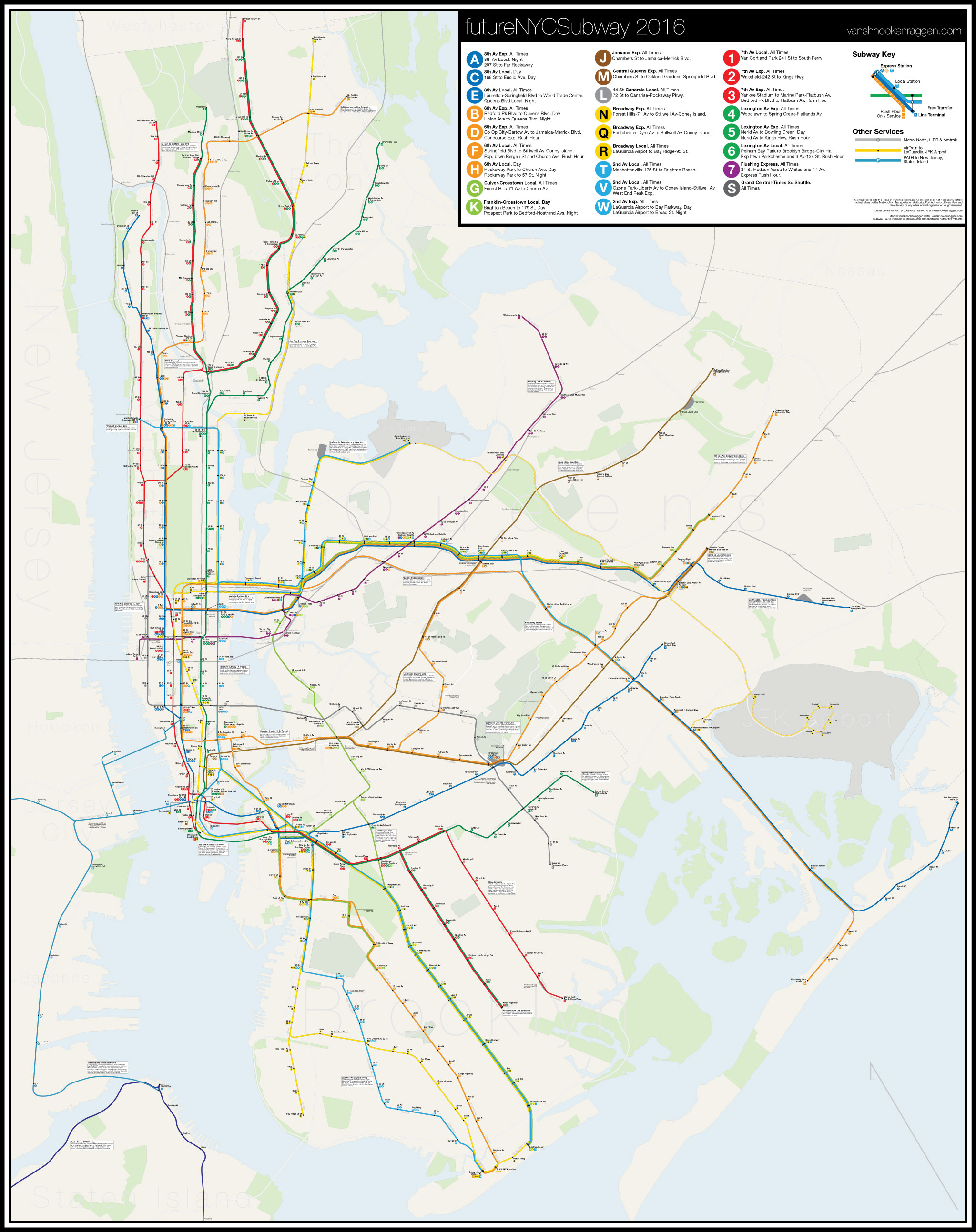
With this in mind I sought to plan out a system expansion which would be as cost effective as possible by addressing current service bottlenecks, train car issues, current ridership and population growth. The Queens Blvd Line is currently slated to undergo conversion to CBTC, a new signal system which will allow up to 40 trains per hour to run (current signals allow up to 30tph but do to a variety of factors this is rarely possible). CBTC is the only way that the G train can be extended back to Forest Hills or, once the 2nd Ave Subway is opened below 63rd St, 2nd Ave trains can run along Queens Blvd. CBTC will take many years to be fully installed on every subway line so focusing on the Queens Blvd Line is a good start but the full impact of the improved service will take time to be felt.
Other proposals deal with small projects with large consequences. Since the IRT opened it has been known that many of the junctions between lines, specifically the Rodgers Ave Junction at Eastern Parkway and Nostrand Ave and the Lexington Ave-149th St Junction on the 5 Line, are bottlenecks which have a serious impact of service. There have been proposals for decades to rebuild these junctions but nothing has ever been done. The Rodgers Ave Junction in particular has been a major road block to the Utica Ave Subway as it would seriously limit trains to Utica Ave and New Lots.
First Stage Expansions
2nd Ave Subway
My most recent concept for the 2nd Ave Subway deals with trunk pairing. Trunk pairing is how each of the three companies which built the NYC Subway designed their systems. The idea is simple: built two trunk lines that run through Manhattan which branch off in the outer boroughs. The branches then merge so that, for instance, riders in the Bronx can at a single station have access to trains that run down either the west or east sides of Manhattan (this was more the case when the 9th Ave elevated line still connected to the 4 train). The IND and IRT were designed this way (more so the IND which learned from the mistakes of the IRT and BMT). The BMT however was focused more on lower Manhattan and designed a system where trains would come in from all over Brooklyn and loop back over the bridges and through the Montague St Tunnel. It worked for a while until the heart of the central business district moved up to midtown. This is why there is so much abandoned subway infrastructure on the Broadway (N/Q/R) and Jamaica Lines (J/Z). This was addressed in 1968 with the Chrystie St Connection which connected the Williamsburg and Manhattan Bridges to the 6th Ave Line (today’s B/D/M trains), rerouting lines through midtown which previously only went downtown. The Broadway Line is now paired with the 6th Ave Line which due to them being a block apart in many places isn’t the most efficient pairing.

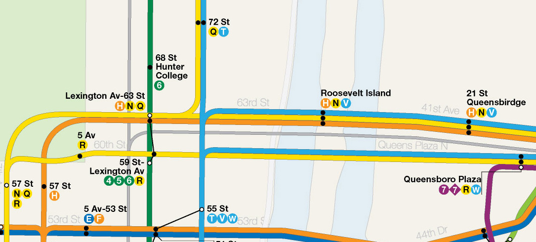
Pairing the Broadway Line with the new 2nd Ave Line would give riders a new one seat option to get to either the west or east sides of Manhattan (or rather central Manhattan and the east side). This would immediately have a major positive impact on transfers at congested midtown stations like 59th/Lexington Ave and 53rd/Lexington Ave. The Queens Blvd Line has two local service, the R and M, but would be much more effective if it was the R and a 2nd Ave train (a restored V train). The M then could then be used as additional express service past Forest Hills. With the addition of express tracks another pairing could be possible by building a new connection between the 2nd Ave Subway and the 60th St tunnel which carries the N to Astoria. The Astoria Line historically had a direct connection to the now demolished 2nd Ave Elevated line and restoring this connection would address many of the transfers at 59th St/Lexington Ave.
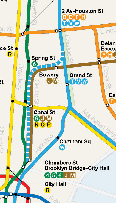
At Houston St the 6th Ave Express trains, which currently run over the Manhattan Bridge, would instead be extended to Williamsburg via a new tunnel to South 4th St for a new line covered below. This frees up space on the Manhattan Bridge for 2nd Ave trains so at DeKalb Ave each Broadway-2nd Ave train pairing would meet and run off to their respectful branches: N/R trains along 4th Ave would be joined by 2nd Ave local and express trains taking over from the D on the West End Line (with peak direction express) while the Q and T run local-express to Brighton Beach.
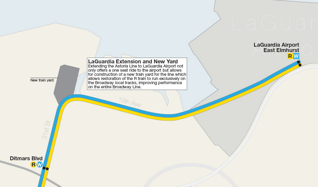
The final part of the plan is seemingly unrelated to the 2nd Ave Subway at all but would have huge consequences in terms of efficiency. Historically the R ran from Bay Ridge to Astoria along the Broadway local tracks while the N ran express and connected to the Queens Blvd Line. This was reversed because the R had no direct access to a train yard (which meant that if a train needed to go out of service or more trains added to make up for a disruption the R trains needed to make long runs along other lines to reach their lines). Extending the Astoria Line to LaGuardia Airport would mean that a new yard could be built north of 20th Ave on land owned by ConEd which is currently fallow. This new yard would allow R trains to return to the Astoria Line. Why is this preferred? This means the R train would run exclusively on the local tracks while the N would share the express with the Q but never have to merge with local tracks along Broadway (this merging causes delays and caps the capacity of the Broadway Line). The N would return to Queens Blvd via the 63rd St tunnel and Astoria and Bay Ridge riders would now be able to see increased and more reliable service on the R train. Riders on the Lexington Ave Line would need to adjust their commute as 59th/Lexington Ave would only allow a transfer to the Astoria Line so all Queens Blvd bound riders would need to transfer at 51st/Lexington Ave. Additionally any Queens Blvd bound rider could also take the 2nd Ave Line instead of the Lexington Ave Line and transfer across the platform at 63rd/Lexington Ave. Segregating transfers would have an overall benefit to service and congestion throughout midtown. Having an Astoria-2nd Ave branch would also remove the need for many transfers at 59th St/Lexington Ave to further reduce congestion.
With funding for Phase 2 of the 2nd Ave Subway cut from the still unfunded MTA 2015-2019 budget it seems almost futile to talk about the future of the project. As with all my past designs looking past Phase 2 would extend a branch west under 125th St to Broadway and a branch north to replace the 5 train to Dyre Ave. The city, in using designs for the 2nd Ave Subway which date to the 1970s, has permanently stunted service to the Bronx on the east side of Manhattan. Only two service can run along 2nd Ave, both local, which means that expanding subway service to under served areas like 3rd Ave or Throgs Neck is virtually impossible. 2016 is not 1971 and it is imperative that the sections south of 63rd St are built as a 4 track trunk line. The additional track will be under used for the foreseeable future but it is important to have it when future demand can fill the void; if the tracks of the 2nd Ave Line are designed properly then it would even be possible to terminate trains from Brooklyn in midtown. 4 tracks south of 63rd St to Grand St would allow better utilization of the East River tunnels between Manhattan and Queens which are already at capacity.
IRT Junction Rehabilitation and the Utica Ave Subway
Since the day it opened the IRT has had capacity and congestion issues. Being the first subway in New York it was designed conservatively to save money and much of these design choices still haunt the system today (you will notice narrower cars on the numbered lines for instance). While the A Division (as the IRT is known internally) was the first to see countdown clocks and CBTC (or whatever similar system the MTA ended up installing) to help with congestion there are some physical limitations which effect capacity. There are two major junctions on the IRT where the 2 and 5 trains merge and their issues have been know about since the beginning. The Rogers Ave Junction in Brooklyn where the Nostrand Ave Subway merges with the Eastern Parkway Subway requires local trains to cross in front of express trains. This limits capacity on the New Lots Line (3 train) and in doing so also makes any extension for the Utica Ave Subway impractical. In the Bronx where the 2 and 5 merge again at 149th St there is an extremely sharp S-curve connecting the Lexington Ave Line with the White Plains Rd Line. This was done to eliminate the need for transfers from the 2 to the 4/5 and this service is immensely popular.
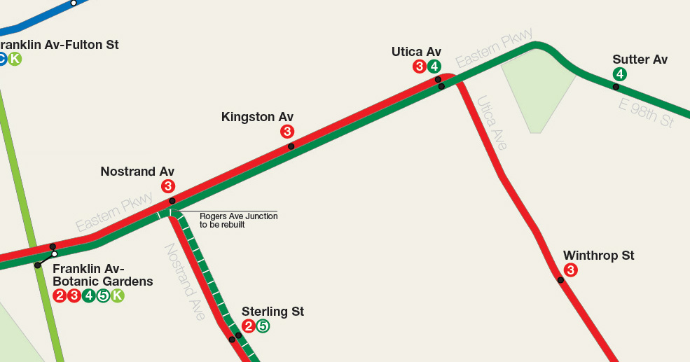
Because both junctions directly impact the entire A Division any delay at either one backs up the entire system. This is why train pairing is so important to the IRT and why the 2/5 runs together in the Bronx and Brooklyn. Reconfiguring these junctions would not only speed up service on the entire system but also enable more trains to run at higher speeds as well as open the door for the Utica Ave Subway.
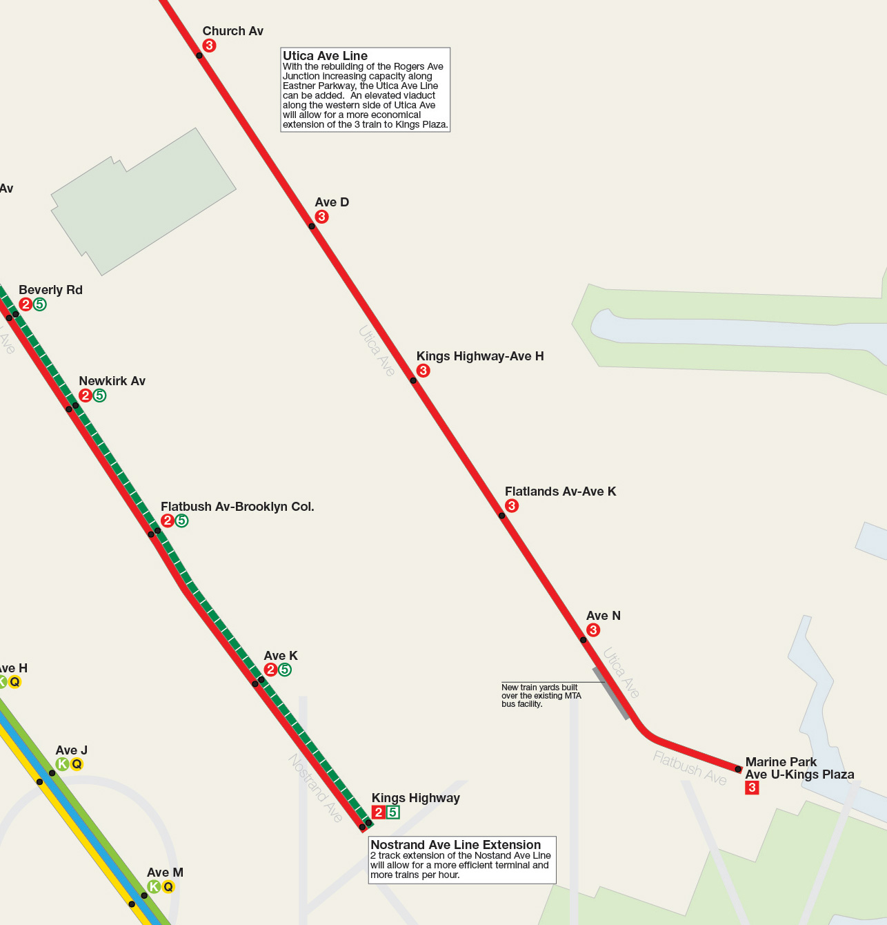
The Utica Ave Subway in this plan would extend the 3 train south to Kings Plaza. In all of my earlier plans I had extended the 4 train down Utica Ave but a closer inspection of how the tracks are aligned at the Utica Ave station shows that it would be much simpler to extend the local tracks south; the 4 express train would take over to New Lots Ave, which should also be extended south through the existing train yards to Spring Creek-Flatlands Ave to support the Spring Creek redevelopment. The Utica Ave Line would run in a tunnel until Rutland Rd where it would ascend and run on an elevated viaduct south to Kings Plaza. The viaduct would run along private land to be taken by eminent domain and designed so that future private development could be built around it. This is the only economical way to build the line and one that would use direct land resale to offset costs.
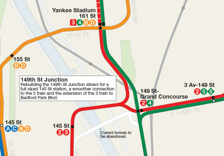
At 145th St in Harlem the 2 train peels off into the Bronx while the 3 terminates at 148th St. The 145th St station, due to the junction with the 2 train, could not be extended to fit longer train sets. At Grand Concourse the 5 merges with the 2 on a tight S-curve. A new alignment would remedy both bottlenecks. Beginning at 138th St at Lenox Ave the tracks of the 2/3 would drop down and run to a new station built below the current 145th St station which would be large enough for a full train set (The current station would still exist but only be used to connect trains to the 148th St Yards and the 148th St terminal would be closed to passengers except for the odd shuttle service). The new tunnel would swing under the Harlem River to 150th St where it would split with the 2 train connecting to the existing 149th-Grand Concourse station and the 3 train swinging up to merge with the 4 train under Franz Sigel Park. The 5 train merge would be rebuilt so it would occur between Grand Concourse and 3rd Ave stations so that the curve of the tunnel would allow for much faster/smoother merges. Service on the White Plains Rd Line (2/5 trains) would be sped up and the 3 train would allow for double the service on the Jerome Ave Line (4 train) up to Bedford Park Blvd-Lehman College where the 3 would terminate (the junction between the main line and yard tracks would also have to be rebuilt to eliminate grade crossings). Furthermore between 161st-Yankee Stadium and 167th St the track bed of the line expands where the 9th Ave elevated line once merged. This extra space would then be used for layup tracks so that 3 trains could terminate late night at Yankee Stadium. This 3/4 train pairing would mimic the 2/5 pairing and allow for service adjustments on the fly.
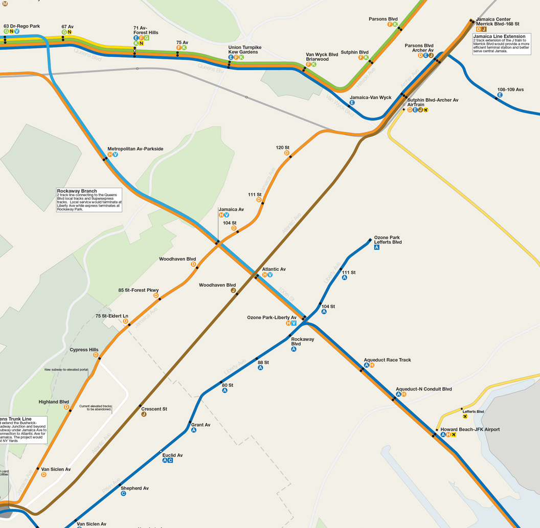
Rockaway Branch Line and IND Queens Blvd Line Extensions
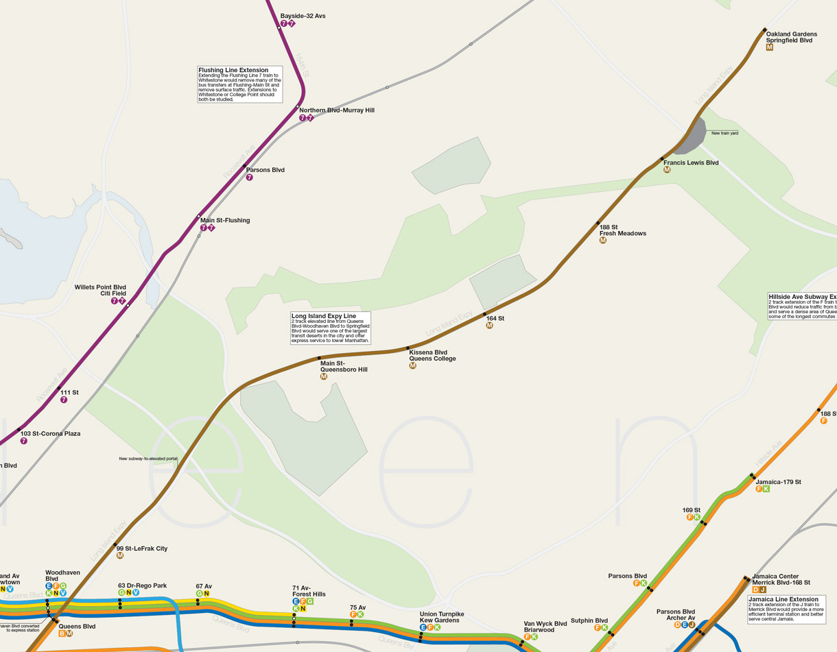
Having only one trunk line subway serving the heart of Queens is a major problem but even worse is that because it was designed to have branches the trunk line doesn’t run efficiently. Famously the Archer Ave Subway extension of the E train was designed to run southeast to Laurelton along the LIRR Atlantic Branch ROW and so the current terminal at Parsons Blvd was not designed to deal with current demand; at rush hour there are a number of E trains which must run out of 179th St. With the addition of the 63rd St Tunnel in 2001 there are even more branches feeding into the Queens Blvd Line which are forced to terminate at Forest Hills or in Jamaica; with two Manhattan-bound local trains terminating at Forest Hills-71st Ave there is no room to run Crosstown G trains past Court Sq. Extending existing branches and building new ones will actually improve overall service along the line but it needs to be done correctly.
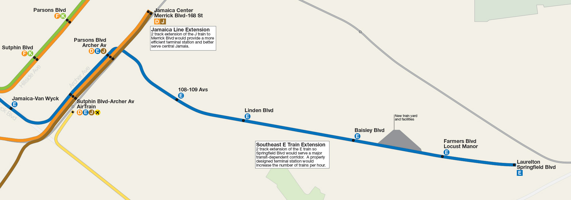
The two most important and needed extensions are the E southeast to Laurelton-Springfield Blvd along the existing LIRR ROW (the subway would actually replace the LIRR service which would be shifted east through St. Albans). This would allow for a proper terminal that would easily handle to high demand along the E line and include a new train yard/shops at a plot of land known today as Railroad Park (which was left as a space for future train storage). The second extension would be off the local track at 63rd St-Rego Park and run along the Rockaway Branch ROW to connect with the A train to the Rockaways. Currently the best set up would be for the M train to make this run but with the addition of the Queens Superexpress Line from the 63rd St Tunnel along the LIRR Main Line to Rego Park the Rockaway Line would offer both local (via Queens Blvd) and express service with trains to 6th Ave and 2nd Ave. (On the service map shown I have 6th Ave H trains running express from 63rd St to Rockaway Park and 2nd Ave V local trains terminating at Liberty Ave. Actual service would depend on demand.)
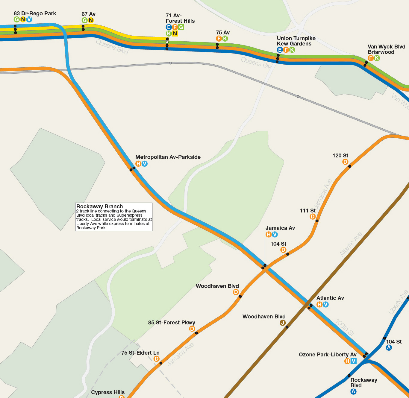
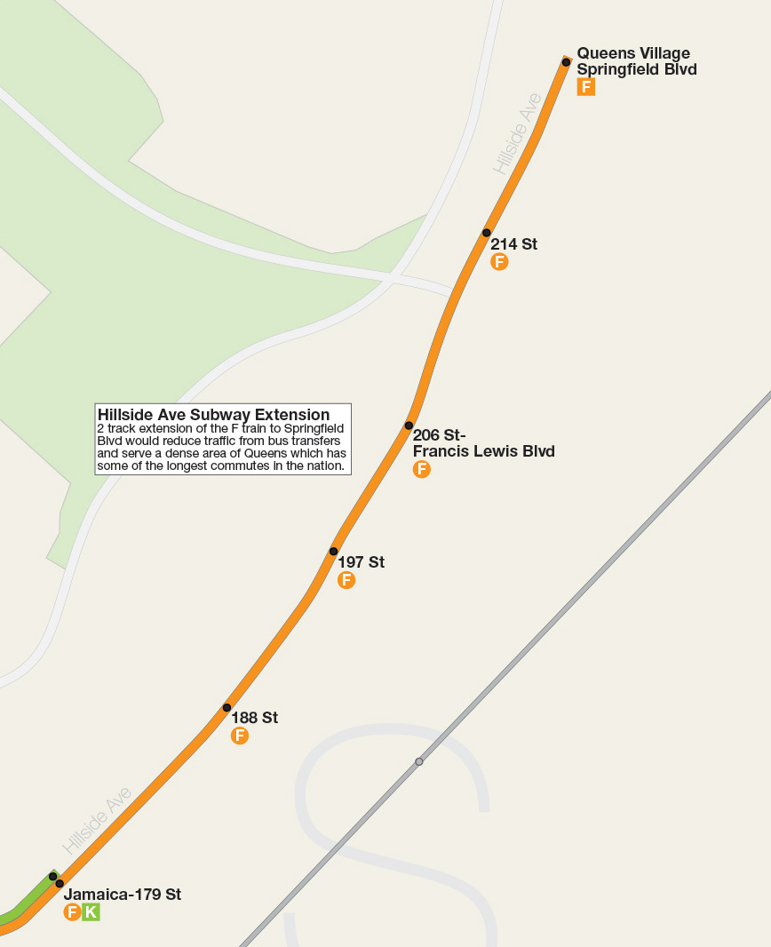
These branches not only offer new service to under served areas of the city but also free up terminal space along Queens Blvd at Forest Hills and 179th St. This allows for the return of the Crosstown G train to run to Forest Hills. A future extension of the Hillside Ave Subway from 179th St to Queens Village-Springfield Blvd should also be looked at do to the high demand coming from bus transfers. Both the E train extension and the Superexpress-Rockaway Branch Line extension would be above ground along existing ROWs to reduce costs. A Hillside Ave Subway extension would be costlier because of both tunneling construction and managing the high water table in the area. It might be possible to build an elevated line but the largely residential nature of the area would discourage this.
Franklin Ave Subway – K Train
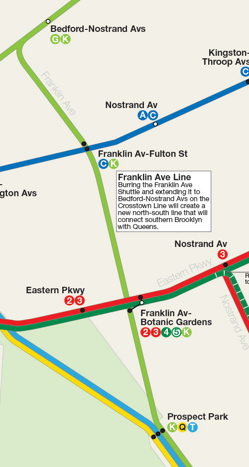
Because the Crosstown Line was never designed to terminate at Court Sq all Crosstown trains would need to be run out to Forest Hills. As I outlined above with the addition of CBTC the Queens Blvd Line can handle such an extension of existing G train service. With both G and K trains now extended from Court Sq some trains would need to run express along side the E and F trains. The Crosstown K Express would terminate at Jamaica-179th St and allow for rush hour F trains to run express all the way to 179th St; local service past Forest Hills has never been popular due to riders switching to overcrowded express trains so making the extra Crosstown service express would pick any slack. Night time service would be reduced to a shuttle between Bedford-Nostrand and Prospect Park unless it proved more popular than the G train.
Second Stage Expansions
Bushwick-Queens Trunk Line
Way back in my very first futureNYCSubway series I proposed bringing back the the gargantuan South 4th St Subway with connections to 2nd Ave, 6th Ave, and 8th Ave via Worth St, as well as branches out to central Queens, Utica Ave, and Broadway Junction. Thinking big is fun but reality has a way to raining on your parade. But the need for better transit to Williamsburg is as important as ever (how we all wish now that at least one of those IND tunnels had been built) and more importantly is cross-borough connections. Better Brooklyn-Queens and Queens-Bronx connections are needed and at the same time the East River crossings between Queens and Manhattan are reaching their capacity. With a 2nd Ave service using the 63rd St Tunnel all the tunnels above 42nd St will be maxed out. The new Bushwick-Queens Trunk Line is a staged plan which will try to address these issues and more in the most affordable way I can think of.
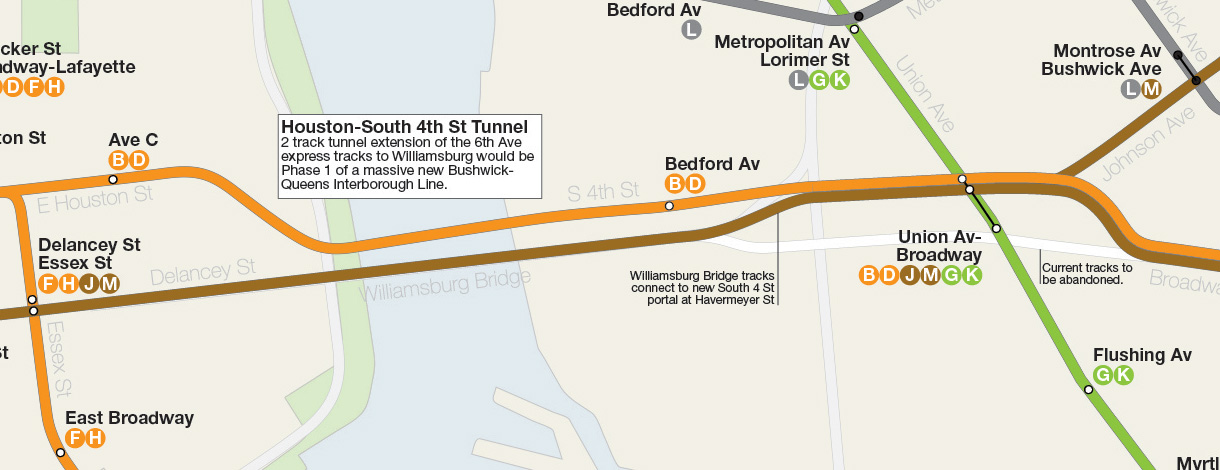
As part of the 2nd Ave Subway plan I outlined above I mentioned shifting the 6th Ave express trains from the Manhattan Bridge through a new East River tunnel to Williamsburg. This is Phase 1. This new 2 track tunnel will continue east under Houston St with a station between Clinton St/Ave B and Pitt St/Ave C then make a southeastern turn through the Baruch Houses along a path with will run under existing open space to where Rivington St would meet the FDR Dr. Headed under the East River to South 4th St to a station between Berry St and Bedford Av and then running to Union Ave where it will terminate using the existing South 4th St station shell at Broadway on the G.
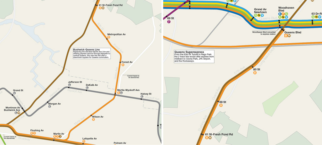
Phase 2 extends the line from Union Ave where will split into a 2 track tunnel under Johnson Ave, which will run past Bushwick Ave (with a transfer to the Montrose Ave L train station) and then ascend and run above ground along the existing freight ROW from Morgan Ave to Flushing Ave acting as express tracks. A 4 track tunnel (space for 4 but only 2 will be built for this stage) will run from Union Ave to Myrtle Ave along Broadway. At Broadway and Myrtle a 2 track tunnel, the local tracks, will run under Myrtle Ave to a Cypress Ave where it will turn northeast under Gates Ave and then north under Forest Ave where it will run to Metropolitan Ave, turn north under 60th St and continue to Flushing Ave meeting up with the express tracks. The now 4 track subway will run northeast under Flushing Ave and Grand Ave to 57 Ave where it will continue east under the Long Island Expressway to Queens Blvd. At Queens Blvd the local tracks will terminate and provisions will be left for the express tracks to extend further east. At this point Woodhaven Blvd station will be converted into an express station. This phase will allow for the removal of the elevated Myrtle Ave Line tracks out to the existing Metropolitan Ave terminal. Non revenue tracks will connect the new subway to the existing Fresh Pond Yards.
Phase 3 will extend the express tracks east along the Long Island Expressway. The most affordable solution is to run them along a concrete elevated viaduct running along the median of the highway much the same way the AirTrain runs long the Van Wyck Expressway. The line will be 2 tracks with island platform stations. The most difficult part of this stage will be placing the needed train yard/shops. While there is space inside Cunningham and Alley Pond Parks it would most likely cause a backlash against the project so it might be possible to build a yard either above or below the interchange between the Long Island and Clearview Expressways. Alternatively the yard could be placed underground around Francis Lewis Blvd where there is abundant park space that could be restored after.
The first three phases replace the existing Myrtle Ave elevated line and create a new express subway for central Queens which bypasses Long Island City and midtown Manhattan but also connects to the Queens Blvd Line should riders need to transfer. This line serves a large swath of the city far from the subway and takes pressure off of midtown transfer stations. Removing the Myrtle Ave elevated will mean that J/Z trains will no longer have to wait for M trains to switch in front of them at Myrtle Ave which will greatly speed up service.
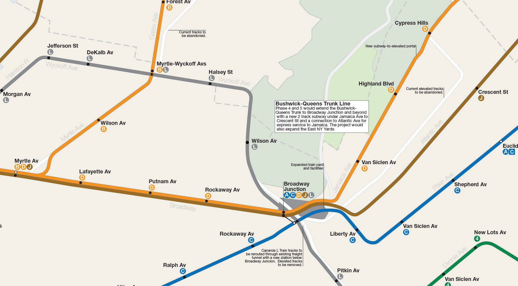
Phase 4 would radically change the Jamaica Line and is left for last as the existing elevated structure (which is already some of the oldest continually used transit infrastructure in the city) will reach the end of its useful life. The Jamaica Line is seeing spillover growth as gentrification moves east along the L train and by the time the first three stages of the B-Q Trunk is opened the demand should be in place to expand. The forth stage has three parts to be built at the same time: extending the 4 track subway from Broadway and Myrtle Aves to Broadway Junction, expanding the existing East NY Yards of the J train so it can handle longer trains, and connecting the tracks of the Williamsburg Bridge to the South 4th St Subway at Havermeyer St. The grade from the bridge to the subway will be a bit steeper than the trains on the Manhattan side of the bridge face so it is possible that the highway ramps on the bridge will have to be moved in order to fit the portal. This connection means that the elevated track from the bridge to Broadway Junction can be completely removed and that northern Brooklyn and central Queens will each have train pairs to take them either downtown to Chambers St or to midtown via 6th Ave.
The fifth and final phase will extend the local tracks from Broadway Junction under Jamaica Ave to a new portal at Crescent St/Jamaica Ave to connect with the existing elevated tracks at Cypress Hills station. The S-curve along Crescent St is a major bottleneck on the J/Z train which necessitates slow travel and increased wear and tear on the trains. Removing this section and replacing it with a subway with only 2 stations (replacing 5 stations which are rather close together) will improve service drastically. The express tracks will be extended south to Atlantic Ave where they will run superexpress to Jamaica along the LIRR Atlantic Ave Line which is slated to be turned into a shuttle once East Side Access opens to Grand Central Terminal. The superexpress tracks will connect to the lower level of the Archer Ave Subway which itself will be extended one station to the east to Merrick Blvd where a larger terminal station will be built to handle the multiple service.
An additional part of this expansion would be to replace the elevated L train tracks over Broadway Junction and reroute the L through the existing freight tunnel which runs parallel to the L. Between the Wilson Ave and Bushwick-Aberdeen stations the L would connect to the other tunnel and bypass Bushwick-Aberdeen (which would be abandoned), a new station would be built under Broadway Junction connecting the new J station to the existing A/C station, then it would surface in the trench below the existing elevated tracks and run to New Lots Ave where it would connect back to the elevated tracks. The Atlantic Ave and Sutter Ave stations would be replaced by a single station at Pitkin Ave.
What will then exist is a brand new system which replaces the bottlenecks of the elevated Jamaica Line with a modern subway that better serves the needs of Brooklyn and Queens riders. The staged construction schedule allows for immediate relief of current congestion in Williamsburg while ridership grows further out. Riders from Jamaica will have a one seat express ride to lower Manhattan as well as a one seat ride to midtown for riders who live in Woodhaven, East New York, and Richmond Hill. Williamsburg, Bed-Stuy and Bushwick will lose their elevated trains and gain better options than only the L train. Central Queens will get an express train to lower Manhattan and a second alternative to midtown avoiding the congested LIC-Midtown tunnels. Built in stages the system can also be adjusted as new demand surfaces as once fast new inter-borough connections are opened riders will have new options about where they live and work.
PATH to Staten Island
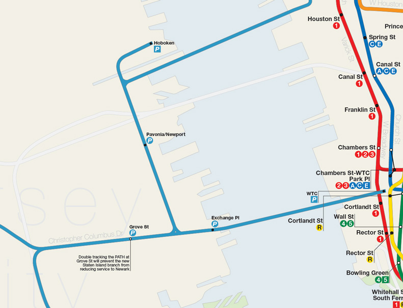
In my last futureNYCSubway update I laid out a plan for using a new Cross-Harbor Tunnel to give Staten Island commuter rail access to greater New York City. With the recent plans for the new Amtrak “Gateway Tunnel” under the Hudson River to an expanded Penn Station coming in at at least $14 billion it would seem that any cross harbor tunnel, which would serve a fraction of the ridership and freight tonnage, would be of similar cost (while a large chunk of the Gateway Tunnel cost is actually for non tunnel infrastructure like expanding Penn Station any tunnel to Staten Island and New Jersey would require expensive support infrastructure as well so costs, while less than Gateway, would still be significant). Because of current bottlenecks in downtown Brooklyn any subway tunnel to Staten Island via Brooklyn (or Manhattan for that matter) would be either detrimental to current service or require expensive new tunneling before any underwater tunnel could be built.
This leaves the PATH train as the only service which could easily handle expansion and offers a one seat ride to both midtown and downtown Manhattan. At first glance it may seem odd that New Yorkers from Staten Island would want to travel through New Jersey to get to Manhattan but that is taking a NY/MTA-centric view of what is a regional transportation problem. Islanders travel through New Jersey regularly via the Port Authority owned Bayonne, Geothals, and Outerbridge crossings. A PATH extension would also take cars off the bridges by offering direct transit access to job centers outside of Manhattan in Jersey City and Newark (and possibly Liberty Airport should that extension ever be built). These factors give more weight to a Port Authority built project than to an MTA or NYC related extension.
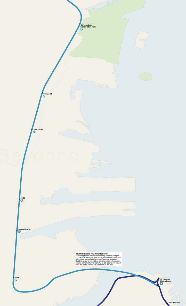
The key to keeping the extension affordable is using the HBLR tracks from Communipaw station to 22nd St. The Port Authority would purchase the tracks from the HBLR; the West Side Branch would be kept in operation but the single track 8th St terminal in Bayonne would be abandoned. The stations would be expanded to fit PATH trains (with high level ADA compliant platforms and the line could either be converted to third rail power OR new dual power trains could be purchased which switch from third rail power to overhead catenary power similar to how Blue Line trains work in Boston. At the north end a new tunnel would be built connecting the PATH along Christopher Columbus Dr to Communipaw. To avoid a bottle neck at Grove St where trains switch from Hoboken/33rd St and WTC bound tracks the new connection would expand Grove St station to 4 tracks with 2 island platforms. At 22nd St in Bayonne the line would wind east and follow the freight cutoff tracks through Constable Hook where it would diver below the Kill Van Kull into a deep bored tunnel to Richmond Terrace at St. George. The SI PATH line would most likely terminate at 33rd St as the SI Ferry would still provide fast service to lower Manhattan. A PATH line to SI would also be a boon for Bayonne as a one seat ride to Manhattan would property values.
Third Stage Expansion
IRT Nostrand Ave Extension
With the construction of the Utica Ave Subway the Nostrand Ave Line (2/5 trains) would see ridership relief so an extension south is less important. The biggest issue facing the Nostrand Ave Line is capacity at Flatbush Ave-Brooklyn College as the station was not designed to be a terminal, an extension south was planned but never built. Extending the line south would address the terminal capacity issue and give residents of southeastern Brooklyn an alternative to the Brighton Beach Line. An extension south would be on the expensive side; the line would have to be in a tunnel the entire route due to the densely developed residential neighborhoods in the area and the tunnel would need to be designed to deal with the high water table in the area. The most economical extension would be to Kings Highway with a possible station at Ave K. The terminal at Kings Highway would have modern storage tracks past the station which allows for more trains per hour to be turned and run.
IND Concourse Line Extension to Coop City
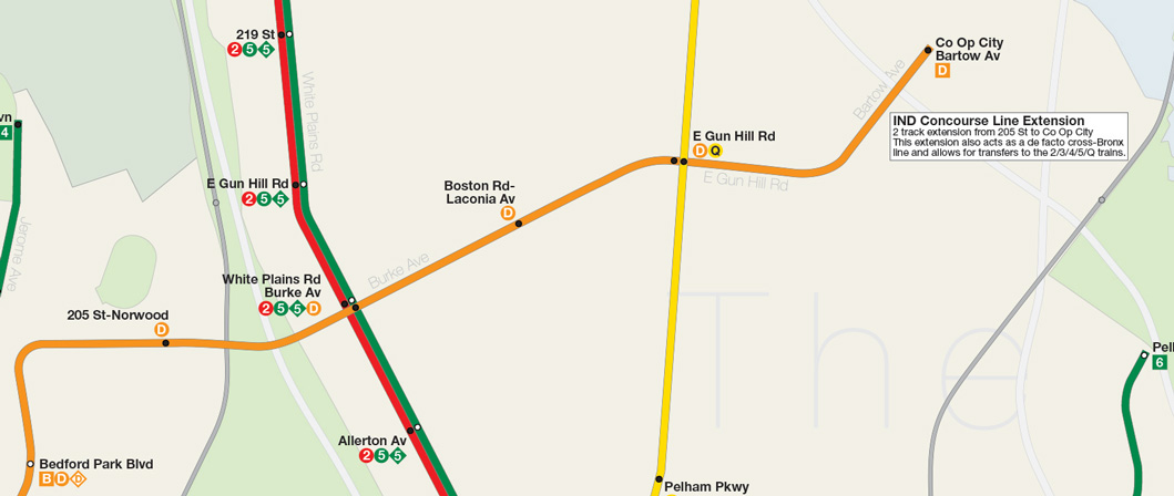
While the Bronx has some of the best subway coverage per borough there are still some holes that need addressing. Because the 2nd Ave Subway is not being built with an express track the options for new service in the Bronx is limited. The only line that can be realistically extended is the IND Concourse Line which was designed for an extension east after Norwood-205 St. The extension was originally rendered moot when the city bought the Dyre Ave Line from the NY, Westchester & Boston RR. The Dyre Ave Line would best be served by extending the Q up from 2nd Ave so that 5 trains no longer have to split service between it and the more heavily used White Plains Rd Line. With the opening of Co Op City there was talk of extending the 6 train from Pelham Bay Park to service the new development but I feel that extending the D train, while more expensive, would ultimately serve the Bronx better. The Bx12 Select Bus Service was the first BRT style service the MTA opened between Co Op City and Inwood-207 St and has proven a massive success. The need for better cross-Bronx service is clear however the costs associated with building any kind of cross-Bronx subway are prohibitive; an ideal cross-Bronx line would connect as many lines as possible and be best located around either 149th or 161st streets. An extension of the Concourse Line would parallel the Bx12 service from Coop City to Fordham Rd as well as connect to the Dyre Ave Q train, White Plains Rd 2/5 trains and Jerome Ave 4 train, finally connecting the A at 145th St. While not perfect it would be the most economical crosstown type subway service.
IRT Flushing Line Extension
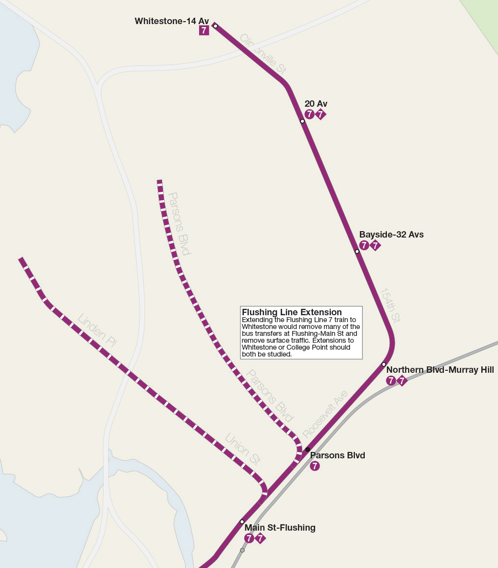
Flushing being the major transit hub that it is needs an extension of the 7 train east to reduce the bevy of bus lines that terminate in downtown Flushing. Extending the line east to Northern Blvd would probably suffice but an extension north to Whitestone should be considered. While College Point is more densely developed than Whitestone extending the 7 train north from Flushing-Main St would be complicated and expensive. The best route for the extension in terms of bus line and population density would be along Parsons Blvd but an extension further east along 154th St would better server all of Flushing. A 154th St alignment may run into more resistance from the more suburban residents of Murray Hill and Whitestone so it’s hard to say which alignment would be best. With the opening of East Side Access the Port Washington Branch LIRR which runs through Flushing will see more trains run and also trains terminating at Grand Central Terminal. Because of this and also the possible implementation of the proposed Freedom Pass (which is very much in concept phase at this point) any extension of the 7 train to Bayside, as originally proposed, would be needlessly redundant.
10th Ave L train
Far West Side development will be adequately served buy the 7 train at 34th St-Hudson Yards for some time. The issue won’t be that the 7 train can’t handle the crowds but can Times Sq and Grand Central handle the transfers. These are the most heavily used stations in the entire system and transferring at either can be intimidating and time consuming. As the Far West Side starts to build out an extension of the L train from 14th St should be considered as a second option for riders to transfer. Additionally an extension of the L, even only as far as 34th St, would allow for a new high capacity terminal to be built which would allow the L train to fully utilize CBTC which was installed but is capped due to the por layout of the current terminal at 8th Ave.
Service Changes
It’s hard to predict how ridership will react to all the service changes proposed but there are smaller improvements which will only be applicable if these expansion projects move forward. When 6th Ave express trains are rerouted to Williamsburg via South 4th St the need for the current 6th Ave M train will disappear. In my plan I’ve replaced the M with the H train as it would be extended to Rockaway Park, traditionally home to the H train. The H, running local along 6th Ave, is now free to provide extra service along the IND Culver Line (F/G). Local politicians have been calling for express F train service for years even though the numbers don’t justify it. Adding an extra service would allow the H train to run express or even day time local while the F runs day time express and night time local.
With the reorganization of the Broadway Line and Queens Blvd branches, Queens-bound riders on the Lexington Ave Line will have to change where they transfer. Combined with the planned growth of Midtown East it would be beneficial to build new express platforms at the 51 St station where the Lexington and the 53rd St Lines meet. Adding express platforms on the three major midtown stations on Lexington Line would reduce the need for local-express transfers at congested stations like Grand Central and 59th St. This has precedent as the express platforms at 59th/Lex were added in 1962 for this very purpose. Riders transferring to Queens-bound trains would be segregated by station: 7 train at Grand Central, E/F at 53rd St, and R at 59th St (with the free connection to 63rd St there is also the transfer to the N to Forest Hills).
The plan is not perfect for all since returning the F to the 53rd St tunnel would require a rider to transfer to the G train at Queens Plaza in order to reach any of the local stations between Queens Plaza and Roosevelt Ave. This reduction of service would be offset with the introduction of the 2nd Ave V local train which would use the 63rd St Tunnel; thus any rider coming from Midtown East could avoid the Lexington-Queens transfer all together and just take one train, the V, between work and home. Again, this kind of radical service change will cause some confusion at first but in the long run will better reduce congestion and give riders more options.
The Bushwick-Queens Trunk Line would reconfigure how the Jamaica Line serves riders by turning it into a two-service superexpress line with M trains running to Woodhaven Blvd and on to Springfield Blvd and J trains running express to Broadway Junction and then to Jamaica Center via the LIRR Atlantic Ave Line which would be converted to subway service. The 6th Ave express trains would run local with B trains running along Myrtle Ave (replacing the current M train) and the D train taking over the currently local J train along Jamaica Ave. The assumption I’m making here is that the local lines would be better served by 6th Ave service as is evidenced by the growth along the M train when it was rerouted along 6th Ave in 2010. The J/M express trains would be focused on providing high speed service to lower Manhattan from central Queens neighborhoods which currently have hour plus commutes downtown. The transfer at Union Ave/South 4th St would also give these riders a fast alternative route into midtown via 6th Ave which would further reduce crowding though Queens-Manhattan tunnels. Track connections would also allow this configuration to be reversed if local residents find J/M local service more favorable and B/D trains would run express to Queens.
The proposed Freedom Pass would be the most economical way to expand service to underserved areas of the city by giving riders a discount on LIRR and Metro North stations within the city and offering a free transfer to the bus/subway network. When the subways were being built in the early 20th century they were done so with a healthy spirit of competition with the private railroads at the time. Now that all these services are under the umbrella of the state run MTA it only makes sense to strengthen the intranetwork connections. Expanding subways along existing LIRR and Metro North right-of-ways makes sense in terms of land acquisition costs but still requires expensive new infrastructure. Already the MTA is looking at new Metro North stations along the Amtrak-Northeast Corridor through eastern Bronx. As I noted above the 2nd Ave Subway lacks an express track which limits the amount of new service it can provide to the Bronx. With the addition of new stations on the White Plains Line a Freedom Pass could offer an affordable alternative to expanding subway service. The 7 train famously was intended to be extended east to Bayside, Queens but with the Freedom Pass this extension would be useless as the Port Washington Branch LIRR would offer faster service to Grand Central and Penn Station than the 7 train.
Finally I’ve thrown in an expansion of the AirTrain which is partly based on Gov Cuomo’s plan for a new line from Willets Point to LaGuardia Airport (which I looked at a year ago). While I much prefer an extension of the Astoria Line I think a connection between the LaGuardia branch and JFK branches of the AirTrain would be an interesting way to create a cross-Queens transit line which would fill the gaps between the subways. The AirTrain, being its own system and costing an additional fee, could serve cross-Queens riders better than an extension of any subway line which would be hard to justify cost wise. Running along the Van Wyck Expressway and through Flushing Meadows Park the extension could be built for relatively cheap as it would not require expensive tunneling.
Nicely done … just wanted to point out one typo in the callout box for the Jamaica Line Extension (D/J) … you misspelt “Jamaica” as “Jamaia”
Thanks! No matter how hard I look there is always a little typo I miss.
No Triboro X Line? L extended to 59th St N/R?
I’ve never been a fan of TriboroRX. I think it was designed solely on being cheap and not on effective transportation. The same connections could be made with infill MetroNorth stations and extending certain subways.
The Bronx choices are interesting. Why the Bruckner/Dyre instead of Third/Webster/Park? Why Whitlock as the transfer instead of Hunts Point? Why the D across Gun Hill instead of the A across Fordham?
Cost. All those other alignments require major tunneling. The Q can be built at grade for most of the new alignment. Extending the D creates a de facto Cross-Bronx line AND it connects to the A at 145th.
Very minor, but I don’t think there is a need to reopen the lower level of Bergen St. With the F and H both stopping at Jay St., the F can skip Bergen St.
You are probably right but I threw it in there for sake of showing the old express stops. Hell, I don’t really think the F needs to be express BUT if you were going to do it this is how it’d have to be done.
How long would you estimate the trip from St. George to 34th Street via the PATH would take?
I’d ball park it in about 40min or less. That’s based on PATH and HBLR times combined. The PATH from 33rd to Grove St is scheduled to take 18min. The HBLR from Marin Blvd (Grove St) to 22nd St-Bayonne is scheduled to take 15 min. Add in the extra time to get to Staten Island and you get about 40 min. That isn’t terrible if you consider the current option of taking the ferry (22min + waiting) and then transferring to the 4 train.
True that the F doesn’t need to be express in Brooklyn, but that is a lot of local stops coming from the old Culver El to Manhattan. Maybe you could set up a skip stop arrangement like with the J and the Z.
It’s the same as today and the ride only takes a half hour. The F doesn’t see that much traffic south of Church Ave so adding faster service won’t really help that many people.
Great job! Always a pleasure to view your maps!
I was just wondering why the LIRR Atlantic Branch was not included?
It is. From Broadway Junction to Jamaica. The section from downtown Brooklyn to Broadway Junction is 2 short blocks from the Fulton St Subway so anyone who needs to can just take the A.
The M used to be my line. It appears that you eliminated the Fresh Pond Rd. station between Forest and Metropolitan Aves. and reinserted it in combination with 61 St. Or did you simply leave out many stations for each line so as not to clutter up the map with text?
The B, which replaced the M, is an actual subway replacement for the elevated train. The new subway will have longer stations and run out to Queens Blvd instead of terminating at Metropolitan.
Ah, I see! You rightly made it into a subway route from Broadway Junction to Jamaica. And since they’ll be turning this section into an LIRR shuttle once East Side Access is completed, seems to make sense! Thank you.
I don’t think getting rid of both the Jamaica El and the Mytle Avenue Els are necessary. I agree that another North Brooklyn trunk is needed, but you should aim to provide more service, not replacing existing service. I would suggest having a four track trunk line via Myrtle Avenue and Union Turnpike as you once proposed. I fully agree with your Bushwick Branch Long Island Expressway Line routing. The Utica Avenue line, I would suggest, should be a branch of the North Brooklyn trunk. One thing I would change is having the Astoria Line services extended into Flushing and then running via the LIRR Central ROW to connect with the LIE line. Having no stops between Astoria and LGA is a mistake as this would provide a great opportunity to provide transit access to those areas. Also, a line connecting LGA and JFK isn’t needed. I don’t know how you are planning to funnel six services onto Queens Boulevard–that is what the Queens Bypass is for. You only have one service running via it. The same goes for the 63rd Street Tunnel. I think another tunnel is needed. Abandoning the (2) tunnels into the Bronx isn’t needed and that shouldn’t be a priority. Expanding into SI and further into Eastern Queens are more important. I don’t like the idea of the Second Avenue – Dyre service as it doesn’t provide new service via a new corridor. You should revert to his old proposal of a Third Avenue Line and a Lafayette Avenue Line. These services could be provided by adding lower level express tracks to Phases 1 and 2. In addition, converting 51st to an express station isn’t needed. I would suggest having four services for Second Avenue to provide service for the Bronx and Brooklyn. Two services via the West End Line aren’t needed, adding one to the Fulton Street Line would be more useful. Also, having the H terminate at Church doesn’t do much. Extending it via Fort Hamilton Parkway and Tenth Avenue to Dyker Heights and 86th Street would be more productive.
Overall, I think that this map is a downgrade from previous maps of your.
Also, not putting in the TriboroRx is a big mistake as it would provide transit access to new pockets of Queens and Brooklyn and would provide more conectivity between routes.
The idea for this map wasn’t to be as fantastical as possible but rather what are the most beneficial large scale projects along with smaller connections that would have a large impact. Because of cost I scaled down the new lines to be as simple as possible.
A note about the six trains along Queens Blvd: I didn’t outline the trains-per-hour in the post but with CBTC this is possible:
Local max: 33tph
– N: 13tph
– V: 13tph
– G: 10tph
Express max: 40tph
– E: 15tph
– F: 15tph
– K: 10tph
Superexpress and Rockaway: 22tph
– H: 10tph
– V: 12tph
63rd St Tunnel (H/N/V): 33tph
So actually there will be excess capacity (CBTC offering up to 40tph) so some of the lines can be fine tuned as demand warrants.
The Concourse Line Extension will never happen though, unless it’s a miracle. Beginning in 2012, a brand new charter school building and its basement foundation was being constructed, and later completed by 2014-2015, right in front and in the way as an obstruction opposite where the tunnel R-O-W current ends at East 205th Street and Webster Avenue, and that would have crossover (or under) the Bronx River. As for the Dyre Avenue Line Connection, the connecting tracks were severed at Lebanon Street some several years ago, and there is now new apartment housing on that same block across the now stub dead-end tracks.
Thanks for this info!
1. Expand Jamaica Center so that it can accommodate the A line from Ozone Park
(hopefully they wont have to close jamaica center to do this. if they do, just add express shuttle bus service to from E-VanWyck and J-121st street during construction)
2. Run the L-Canarsie express downwards along Flatlands Ave, then along Kings Hwy to the B/Q-Kings hwy and then run it across to F-Kings hwy and N-Kings hwy (providing quicker route to Coney Island and Brighton Beach)
it should say Nereid in the service guide
Changed it, thanks!
The PATH connection to Staten Island is problematic.
1) Most of the traffic coming off Staten Island at rush hour isn’t headed to Manhattan. It is headed to Brooklyn and Queens. The PATH idea helps, but there has to be a subway connection to Staten Island.
2) A tunnel across the Narrows to hook in with the 4th Avenue line at 36th Street is the best way. One stop from there and you have access to half a dozen subway lines plus the east bound LIRR. But this is only half of it.
3) A cross harbor tunnel from St. George should go to Red Hook, Governors’ Island, and then to Whitehall. That tunnel should have a spur to the 4th Avenue line as I described in item 2.
4) Such a tunnel does not have to cost as much as the planned Gateway project. It doesn’t not have to be a bored tunnel. It could be done, faster and cheaper, if built like the Ft McHenry Tunnel in Baltimore- pre-fabricated pieces that were buried into the dredged harbor floor.
5) Commuting off island is only one problem here on Staten Island. Local traffic is an absolute night mare. An extended 1 train across the harbor can’t just stop at St George. It needs to continue down Victory Boulevard to at least Richmond Avenue; possibly further to the Staten Island Corporate Park.
6) A North Shore rail line would be even better if it went over the new Goethals Bridge and linked up with NJ Transit.
7) The existing Staten Island Railway should also go over the Arthur Kill and link up with NJ Transit’s North Jersey Coast Line (which by the way, NJ should extend all the way to Atlantic City..maybe that’ll help them.)
8) Staten Island has a couple of places that can use street car systems. Hylan Boulevard is 70 to 80 feet wide and traffic moves glacially at most times. A separated streetcar system could truly speed things up over the buses that currently crawl. Clove Road, from Hylan Blvd to Richmond Terrace is a vital cross island street, parts of a street car would either need a tunnel, or have to share the street in narrow parts.
In the end, what most people do not realize about Staten Island is that it is rather large- by area, larger than the Bronx and Manhattan combined. We also have a population of about 500,000 people and other than one train that serves one side of the island (I live here almost 49 years and I’ve been on the SIR twice.- the last time over 30 years ago.), we have incredibly slow moving buses and lots and lots of cars. The only way to solve the problems here are street cars separated from other traffic and subways.
Thanks for this thorough breakdown. I admit I’m not that familiar with SI and how people travel. The point of the PATH extension was to find the cheapest solution for a one seat ride to Manhattan. Even though it would be the best alignment I’m not a fan of using the 4th Ave Subway because the express tracks are already full. The West End Line would need to be rerouted in order to give space for the SI Line. SI is the one place in NYC that could support a light rail line (or network) and I think that local pols need to get their shit together if they ever want to get anything done. From what I’ve seen it is just a bunch of pro-car anti-transit NIMBYs yelling against improvements.
Really digging this. What do you think about a walking transfer a la the new Court Sq 7 connection? This one would connect Queensboro Plaza and Queens Plaza – a connection that currently involves walking down a street between the Queens Blvd bridge and Queensboro Bridge.
The Court Sq works fine enough. Yes it sucks that you have to transfer twice to get from the E/M/G to get to the N but IDK how many people it would realistically attract, especially since the N and R merge at 59th St.
We’re in a sort of Catch-22 here- we’re attached to our cars out of necessity, yet pleas for more mass transit go unheeded, so we use our cars more and we get chided for being “car-loving.”
I’m actually friendly with a couple of local politicians here- and most of them would love to see a light rail on the North Shore, or some connection to the HBLR. They’ve been pleading for ages for a fast ferry from the south shore that could get people to Wall Street in about 45 minutes (currently, the average commute from Tottenville to Wall Street is around an hour and a quarter. The north shore rail idea has been around for years and year- the MTA doesn’t want to know about it; and the mayor seems to be the same. Yet, some real estate people from Brooklyn come up with pretty drawings for the BQX streetcar and suddenly there’s $2.5 billion for it and we can even get a a few million for a design for light rail. To say it pisses people off here is an understatement.
The reason Select Bus Service wasn’t greeted here with smiles is because it took a lane away from traffic on Hylan Blvd. (Happily, I live on the other side of the island and rarely have to go there.) The bus ride might be a bit faster, but it really did make traffic worse.
Right now, our Borough President and the MTA are involved in a grand review of all island bus routes- local and express. That hasn’t been done in over 30 years. Hopefully, it will bring changes that make things better. One improvement that is on the way, is a bus lane over the Verrazano Bridge. That will create a single bus lane from Victory Blvd all the way to the Battery (Carey) Tunnel. That should slice about ten minutes off of a lot of rides.
Finally, just want to say- love your work. How do you produce these maps? (What software?)
Thanks! I always love talking with people more familiar of local issues since it only helps me come up with better plans. I think SI would benefit from a more well-rounded transit package than just a subway or whatever. One of these days I’ll know more about it and make a dedicated post. I honestly would love to see a rail tunnel under that harbor that would allow trains to run from NJ to Long Island. The right service pattern would give SI so many better options than just the bridges. Additionally I’d love to see an engineering report look at the feasibility of rail on the Verrazano.
I start off my maps sketching ideas on Google Maps and then I move over to Adobe Illustrator. I’ve been doing it long enough that I have base files to work off of and I can wing a lot of it from muscle memory.
The transfer at Queensboro Plaza/Queens Plaza would be great. It would provide better access to the Astoria Line! It certainly help tourists who get confused!
What is needed is for the replacement of the MetroCard to be able to recognize the transfer and comp it. That would be considerably cheaper than building an 800ft tunnel.
Why do you have two services running down the West End Line? What I would do, taking into account of saving money, is to connect the Montague Tunnel to the Fulton Street Local tracks. This would get rid of the bottleneck of the Cranberry Street Tunnel that ensured that only 26 TPH could operate via the Fulton Street Line. With this connection, the A and C could run express in Brooklyn, and the Second Avenue service could run local to Euclid. The C could then take the Ozone Park branch.
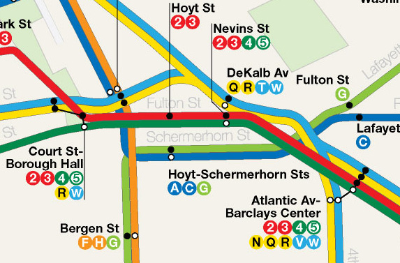
Given current demand on the Fulton Line vs 4th Ave Lines and the fact that the MTA is going to install CBTC on the Cranberry St Tunnel I think that two trains can handle the needs of Fulton St for a while. The W would terminate at Broad St nights and weekends and would be extended to Bay Parkway to allow for express V trains to run peak direction. This also keeps the R and W paired longer so that should trains need to be rerouted due to a problem on either the Broadway or 2nd Ave Line. Should demand shift and ridership grown on the Fulton Line more then a connection between the Montague Tunnel and Hoyt-Schermerhorn should totally be looked into.
Why do you have the 5 terminate at Bowling Green during mid-days? It was like that until 2009 when the 5 was extended to Flatbush during this time.
Also, it is not the Staten Island Rail Road. It is the Staten Island Railway.
Will the demand be there, especially with the new Utica Ave Subway added and the Rogers Junction reworked to allow more trains? I can’t predict what the demand will look like when the expansion plans open.
Another thoughtful attempt to better transit for the city.
Though I do think there were some low-hanging fruit I’m surprised you didn’t include.
1. An extension of the L Train along the Bay Ridge LIRR ROW would revolutionize east-west travel through Brooklyn.
2. My rail connection to LaGuardia would be a crosstown line across upper Manhattan (either 86 or 96 would do) along the Grand Central to downtown Flushing, before turning south to continue deep into Jamaica, maybe to JFK.
3) Turning your revamp of the Jamaica Avenue BMT into a local-express that can take pressure off the E/F.
4) Rethinking the Queens Avenue IND, by laying track between Queens Plaza and Grand Avenue and creating more capacity by running an express line along it and providing service to new areas.
5) No extension of SAS along 3rd Avenue/Park Avenue line in the Bronx? It’s a slam dunk for anyone stuck on the Lexington lines.
How long would you guess it takes to ride the H superexpress from, say, Rockefeller Center to JFK?
45min?
Would you be willing to share a hi-res PDF version? It’s hard to get a look at all the changes without being able to zoom in.
The high res PDF is linked on the site through the image.
One suggestion I’d like to make is a change in the route of the line from Second Av. and Houston St. to the S. 4th St. station. My suggestion is to put the tunnel a little further north so that the first stop in Brooklyn would be to co-locate it with the L stop at Bedford and N. 7th St. From there you could then route it down to the S. 4th St. station and on from there. While the proposed stop at Bedford and S. 4th St. would help, the current Bedford L stop is one of the busiest outside of Manhattan at almost 10,000,000. The co-location could be to expand the station in width to a regular express type stop or to build a second level below the current Bedford station.
I saw that PDF but it’s still pretty low res, gets pixelated when you zoom in.
http://www.vanshnookenraggen.com/_index/wp-content/uploads/2016/02/fnycs_2016.pdf
I think this might interest you- It’s a study of alternatives for the Staten Island North Shore rail right of way. http://web.mta.info/mta/planning/nsaa/pdfs/FinalReport.pdf
I play around with fantasy rail line on Google Earth as well…. I have Illustrator…have to figure that part out.
Is the Park Pl. stop on the K removed intentionally or is that an oversight?
Intentional. Where the Park Pl station is is where the new portal would be built to the new subway. The new Fulton St station would be built for 10 car trains and the Botanic Gardens station would be expanded to hold 10 cars as well. Rebuilding Park Pl for 10 cars (it holds only 2 now) would slow down trains too much since the station spacing would be so close.
Awesome job. I’ve lived in Washington Heights my whole life, and I would add a cross bronx line heading west into manhattan, then across the GWB bridge to Fort Lee, and from there a commuter line out west to Paterson hitting Hackensack, Teaneck, Paramus, etc. (Basically along Route 4.)
Hey. I have a slight modification to propose to this map. Building on your concept of pairing, why not swap routings between the C and H trains (or, alternatively, the C and F trains) between W 4th – Washington Sq and Jay St using existing infrastructure? This would allow South Brooklyn riders to better access the Lower West Side, and also allow those on the Lower East Side to better access the Fulton St corridor. The E and A trains combine to serve all stations south of W 4th St on Eighth Ave, so the C is a good candidate for a reroute here.
Given that the connections already exist, I can’t see how this wouldn’t be beneficial in some way, especially since this would come at a negligible cost.
Addon to my previous comment – rerouting the F could be a better idea, given that rerouting the H creates a situation in the Rockaways where both lines lead to 8th Ave and ignore the Lower East Side. As well, perhaps the rerouted C could be extended to Lefferts Boulevard (adding on to the A, not replacing it) so that the concept of pairing could be better extended. Although the C would still be a primarily 8th Ave train, I feel like lower Manhattan will be better served with rerouting the C via lower 6th.
The switches at Jay St and W4th do allow this kind of routing but they also slow down trains which have to wait for the switch to go back and forth. In that same time a rider can just transfer at Jay St or W4th and this speeds up service for all riders along the line. The difference with the 2nd Ave/Broadway Line pairing is that the lines are forced to merge with one another (which is why the IND was designed the way it was in the first place). Anytime you add a place where trains have to switch from local to express tracks slows down how many trains can run. This is an inherent problem with the IRT and BMT but the IND was overbuilt to avoid this where possible. This is another reason why pairing on the IRT and BMT are more important than IND lines since the pairing trains try to offset the delays inherent in the system.
Would adding a peak-direction express service running along the third track (where it exists) of the northern section of the B’way-7th Ave line be of any value? Although running trains on the section from 96th to 145th Sts would speed up commutes from the west Bronx (keep in mind here that local commuters in upper Manhattan can use the nearby B C trains), I’m not sure if running trains on the section between Dyckman and 242nd Sts would do any good, seeing as it would take away service from local stations in an underserved area, with no easy alternative north of 207th St.
@sam21212: The stations between 96th and 145th (Columbia, 125th, 137th) are all pretty busy, so skipping them would be counterproductive.
Alright. How about extending the V to Howard Beach – JFK, routing it on the unused express tracks (for an easy turnaround) and turning Howard Beach into an express station (i.e. turn the existing side platforms into island platforms by building a track on the other side, leaving the middle express tracks as surplus). The V would then use existing switches and relays to turn around after HBeach. I think this would improve connections to the airport (there would then be 6 services on 4 trunk lines serving the AirTrain JFK).
I thought about this too. It’s probably a good idea. I think I terminated the V at Liberty Ave because there was more room for terminal layup tracks before the line merges with the A. I’m not 100% sure Howard Beach/JFK would need 3 trains but given the short distance and existing tracks it may be affordable enough to pull off.
Have you looked at the Shonan or Chiba Suspension Monorail? Understandably, Monorail has a bad connotation (think Marge Simpson vs the Monorail). However, this sort of tech has been working for decades without incident and could work well for narrow streets or even primarily over highways.
The Shonan Monorail is pretty unique where in some sections of rail is a single track. At every other station or two stations, they would split to allow passenger pickup and opposite direction trains to pass through. Sounds like money savings to me. If only Americans can be so precise like the Japanese. 🙂
While going through Google Maps, I noticed a rail line in southern Brooklyn that runs from the N, across the D, F and Q (in an east-bound direction), past Flatbush Ave/Brooklyn College terminus of the 2&5 lines, then gradually turning north where it joins the L train at New Lots Ave. From here it follows under the L and breaks away north of Wilson Ave when the L turns west towards Manhattan. This same rail line then passes the M at Metropolitan Ave, the 7 at 69 st and the E,M,R at 65 street. It’s then joined by the Amtrak out of Penn St. and continues North West where it passes the N,Q terminus in Astoria. It’s then routed via the Hell’s Gate bridge over Randall’s island into the Bronx at Port Morris.
Assuming the line is currently lightly used, I feel like this can be a cheap way of creating a direct Bronx-Queens-Brooklyn route that connects so many lines. Further, this line could be routed to cross the 2 & 5 at Grand Concourse and terminate at Yankee Stadium.
In Mumbai where I come from, there are some rail/subway lines that are used for both subway and freight, as the freight services are only 3-4 per day. What are your thoughts?
What you are talking about is the proposed Triboro RX which I’ve covered on this site before. I like it in theory but when you break down the details I’m not so sure it is a worthy project. This is based on the cost of upgrading the entire ROW, most of which never saw passenger service, for questionable ridership when you could spend the same on subway improvements and serve much more people. It’s good on paper but unless the city and state decided to get radical with intercity commuter rail (like better integrating MetroNorth and LIRR) then I don’t see anything happening with it.
the Triboro Rx would provide service to new areas and would provide transfers to many lines. I would use it to go to Brooklyn instead of going to Manhattan for instance. I think that it would be a wonderful investment.
Amazing job with this plan; being a New Yorker I can attest to the somewhat lackluster nature of the subway. I can see the vision you have painted with this plan, and I must say it’s surprisingly feasible and realistic (especially compared to the earlier versions of your plan).
I am also interested myself in making such a subway plan (although nowhere near as comprehensive as yours), so I’d like to know if there is a version of this map that does not have any subway lines on it or only has the existing NYC subway system.
I also think it would be quite fascinating if you created a track diagram of your proposed extensions and variations. I urge you to make one if you haven’t already; besides the tracks are more important than the services as you could always change around the route of certain lines (like what happened to the M).
By the way, have you gotten any official feedback from the MTA or otherwise? I think they should seriously consider some of your proposals
Funny you mention the track diagram because the way this whole project started was me sketching out a new diagram from scratch and it kinda got out of hand. I still have a full system one but it is from an older version of this project so I don’t know if I want to go back and update it yet.
The MTA, at least some people there, do know my work. The problem isn’t with them but leadership in Albany and City Hall who control the $$$ to get these things done. Until Cuomo is removed from power no one at the MTA would ever come out in favor of anything like this. In fact in the past large scale system expansions like this were always proposed by mayors or governors. We need better leadership at the top.
I found another mistake. It says Leonx Avenue.
I have a few problems with your map.
1. There aren’t enough stops on the Rockaway Beach Line. Stops should be at Fleet Street, Metropolitan Avenue, Union Turnpike, Jamaica Avenue (with a transfer), Atlantic Avenue and finally Liberty Avenue
2. To compensate for the loss of Locust Manor, an additional stop should be added on the LIRR
3. The 5 should operate in Brooklyn during middays
4. There is No TriboroRx. This is the biggest problem. This would provide service to new communities in Eastern Brooklyn and Central Queens. And it would provide new transfer opportunities. It would ease so many commutes. I don’t know why you don’t have it on. It would not be a subway line. It would be a rapid transit operation over a railroad line.
5. There are no stations between Ditmars and LGA. I know people in that area who would love a subway line. Stops should be added at Steinway, Hazen and 82nd Street.
6. Your decision to take over the Dyre Avenue Line is a poor one in my opinion. In doing this, only one new stop is built. Yes, it would save time, but other areas of the Bronx are desperate for transit. I think that you should have built a line via the Bruckner Expressway, or the better option, which is a line up Park Avenue or Third Avenue. Instead of your Gun Hill Road Line, I would build a Fordham Road – Pelham Parkway Line. This has multiple benefits. It would serve as a true crosstown line. Your line has no transfer to the A, 1 and 4 trains. My line would start as a branch of the Eighth Avenue Line going from 207th Street Yard under Fordham Road and then emerging as an elevated line over Pelham Parkway to Co-Op City. The elevated portion would reduce the cost. At Fordham Plaza, the Park Avenue Line would merge in. At Fordham Plaza there would be a 3-track station so that A trains could terminate there because of the long length of the route. I would still extend the Concourse Line but only to White Plains Road. Also, the Pelham Line should be extended to Co-Op City.
7. Your North Brooklyn line is too far south. I would have it branch off of the Second Avenue Subway at 8th Street before crossing the East River and going down Grand Street. Prior to that point, a branch of the 6th Avenue Line would merge in. Then it would continue until Bushwick Avenue, before turning south. At Montrose Avenue, a branch would continue onto your LIE line, and another branch would continue southeast via Utica Avenue.
8. I don’t know why you think it is a priority to eliminate the Jamaica El. It is still usable and the money should be spent elsewhere. I do think a third track should be added and to avoid the two track area, the line should go over Jamaica Avenue in the portion where the line currently does not.
9. I would close a few stations. The 18th Street and Franklin Street stations are too close to the 14th Street, and Canal Street stations, respectively.
10. You should add a few more free transfers. A transfer between the Seventh Avenue – 53rd Street station, and the 57th Street – Seventh Avenue station would be great. Also, add a connection between the Prince Street station and the Broadway-Lafayette/Bleeker complex. Finally, you missed out the most important one. The transfer between Queensboro Plaza and Queens Plaza.
11. Add a station at Rosebank on the SIR.
Hey man, thanks for such a thorough response. Here’s what I’m thinking:
1) Because of both the low density along the route and distance that an all local Rockaway train makes it doesn’t make sense to have too many more stations along the line. The suburban nature of the area means more people drive so spacing stations further apart means a faster ride for subway riders who can connect to local buses or parking lots.
2) Riders aren’t going to take the LIRR to the end of a subway line to transfer, they are just going to take the subway or the LIRR all the way. The loss of LIRR stations along the route it made up for buy the subway which is a cheaper ride.
3) Sure, the map isn’t set in stone.
4) I am not a fan of TriboroRX and think it is a solution looking for a problem. The sales pitch for the line is that it would be a cheaper alternative because it wouldn’t require digging new tunnels but I think planning a transit line based solely on affordability is a recipe for failure. To upgrade the current line, add new stations, buy new trains, and build ancillary infrastructure will still end up costing tens of billions of dollars so why not spend that same money on strategic improvements on the existing system which will help more people in the long run? The connectivity of TriboroRX is also suspect since there area key areas where it is supposed to serve which are a bit far off from the line. Tunnels could be built but then that increases the cost substantially. Again, the details don’t really pan out.
5) The area through which the Astoria Line Extension runs is either industrial or very low density housing. There is no one there who needs infill stations. Rerouting bus lines in the area would suffice.
6) No doubt that the Bronx could use more subways. I send the Q up Dyre Ave because it is an affordable option that will give express service to thousands of Bronx riders but it isn’t perfect. The worst thing about the current 2nd Ave Subway is that there is no space for express service to the Bronx. This limits any new service. I feel that extending the Concourse Line would suffice for a crosstown route because it would connect to all but the 6 train in the Bronx. I’m more in favor of increasing Metro North service with reduced fares to serve 3rd Ave and Coop City.
7) I’ve looked at such a routing and while it would be more balanced for north Brooklyn it would be more difficult to connect the 2nd Ave with 6th Ave (requiring two East River tunnels as opposed to one) and rule out any connection to the Williamsburg Bridge (which adds redundancy). I am also not a fan of the 2nd/6th Ave-Utica Ave idea mostly because it would add duplicate service through northern Brooklyn and double the cost of the Utica Ave Subway if it was an extension of the Eastern Parkway Line. And let me clarify what I mean here, especially in regards to the Jamaica El replacement: if a 2/6 Av Utica Line is built it will only take riders away from the existing Jamaica Line which still leaves the same service limitations for thousands of riders coming from eastern Brooklyn and southern Queens. Building only the Eastern Parkway-Utica Ave section would save billions which could then be spent on the Jamaica Line improvements.
8) The Jamaica El/Bushwick-Queens Trunk is a long term solution for current congestion and future growth. The El structure on which the Jamaica Line runs is one of the oldest sections of track in the entire system and lacks modern track designs which limit the amount of service it can hold. The connection to the LIE line creates a fast inter-borough connection which also takes pressure off of the East River tunnels between Manhattan and Queens. Gentrification will only move along the line so upgrading the entire thing out to Broadway Junction is something that needs to happen eventually.
9) With ridership at all time highs why would you want to close stations?!
10) I’ve considered this but the costs of building these transfers are quite high (given they need to dig around all the existing buildings and infrastructure). When riders have existing transfer options a few stations away it doesn’t seem worth the cost.
11) I didn’t really look at Staten Island but this is a possibility.
I Think What The Subway Needs Is The Express Track In Brooklyn On The G Line To Be Reopend To (G) Trains (F Trains Are Not Frequent Enugh)
The way the tracks are laid out G trains cannot use the express tracks. It was designed to be local only and realigning the tracks would require blowing up a large chunk of Boerum Hill. It’s just not worth it.
Not the OP, but…
2) What about people reverse commuting to Long Island? All of a sudden their only option is St. Albans.
4) The areas that TriboroRX aren’t small. East New York and Jackson Heights are pretty big transfer hubs, and the buses the alignment parallels in Brooklyn are some of the busiest. Not everyone is trying to go to Manhattan.
Bus routes would be altered with any major subway extension to account for the change. And since most people out there have cars I don’t see that effecting enough people to justify a new station.
I’m not saying that it doesn’t have merit, especially Broadway Junction and Jackson Heights, rather my argument is that spending the same billions on upgrading and expanding the ROW for passenger service should be used on other strategic investments and expansions that would help the same people AND reduce congestion for Manhattan bound riders (which is the majority). The TRX would certainly help interboro commuters but not address the congestion facing Manhattan commuters. To put it another way the RPA wants to build one line while the rest of the network stagnates when we should be fixing multiple connections around the network to help as many riders as possible.
Just found a few typos:
1)It says ‘airpot’ instead of ‘airport’ under the R in the service guide,
2)Under 1 in the service guide it should be Van Cortlandt Park-242 St instead of Van Cortland Park 241 St
3)Under 2 in the service guide it should be Wakefield-241 St instead of 242 St
I already mentioned the latter two but nothing was done
Thanks man, fixing it now.
I’ve also added a short extension of the B from Queens Blvd to Flushing Main St. This was something I originally had but took out last minute due to the cost of digging under Main St. I think that such an extension, though, would be worth the cost and give more relief to the 7 train than anything else, or more bang for the buck then a full scale Northern Blvd Subway.
I am also Union Tpke. I found another mistake. You wrote Newkirk Avenue instead of Newkirk Plaza on the Brighton Line.
It would probably be easier to just change the name of the station than get some of these extensions built! LOL. I’ll change it in the next update.
Totally pie in the sky… but I would love a station built at 103rd in Manhattan on B/C line to connect to 2/3 trains.
As evidenced by “Tracks of the New York City Subway” book by Peter Dougherty, one set of tracks runs above the other. Would be a nightmare to build, and $$$$ galore… But !!!
I love this new map and most of the extensions, however, I thought you should have implemented your IntraCity Rail System. That system really inspired me to not only better it but also to make it
so that improved travel for the millions of NYers who use the transit system we have to get through and into all of the boroughs.
So my thoughts were that you could create a more high capacity system that acted as a commuter metro, and to try and reduce the amount of crowding on commuter rail going into the city by allowing riders to bypass the central stations.
Secondly I thought you could make another subway or IntraCity line that utilizes the Bushwick branch of the LIRR to better serve the extremely dense neighborhoods of Greenpoint and Williamsburg.
Finally what are your thoughts on connecting the NQR lines with the J line at Kenmare Street after Bowery station so that riders from Williamsburg have another, quicker way to get into the city avoiding a transfer or another wait for the train; also so that they have another alternative when the L train shuts down; and so that riders on the B46 SBS have another train to get them into the city. My idea would be the use of the new W train which would run into Williamsburg after branching off from the NQR at 8 st, go over the bridge and then running along the Broadway to some terminus.
Is the link to the PDF broken?
Fixed! Thanks for the catch.
I remember on your old maps you included a few extra stops on the lower trunk of the second avenue subway. You placed a stop in between 14th Street and Houston and then eliminated the 55th St Stop to create a 50 St and 57 St stop. Is there a reason you removed those modifications? Phase 3 & Phase 4 are definitely not set in stone and you did take the liberty of giving the lower second avenue subway express so I think that adding back those stations is reasonable.
I recently came across this interesting proposal on realtransit.org, and if you haven’t already looked at it, I recommend you to read it: http://www.realtransit.org/laguardia.php#. Basically, they’re proposing an additional branch of the IRT Flushing Line to go to LaGuardia Airport via Sunnyside and then continue on to Willets Point. Connecting the 7 (or rather the 8) to LaGuardia is in my opinion a far better option then connecting the Astoria Line, albeit being a more expensive option. LaGuardia would now be directly connected to Times Square as well as Grand Central and also with the Javits Center, Sunnyside and Willets Point.
This would drastically reduce more important service to Flushing. This would only work if it were 3 TPH. It cannot work.
Branching off the Flushing Line is the worst idea possible. Ridership and growth is so high along the 7 that any reduction in service would be crippling. The only place you could realistically branch off the 7 is after Willets Point station and even this would hurt Flushing. The Astoria Line can still handle the additional traffic and would cost far less than this proposal.
I’ve noticed that you’ve persistently included 4-track service on the second avenue subway for phases 3 and 4. However it seems unlikely that (in the case they come to fruition) phases 3 and 4 will include express tracks. The stops on the proposed phase 3 segment of the second avenue subway are further apart then all of the other lines. As I’ve mentioned previously, both the official plans and the current iteration of your map do not include a station in between Houston and 14th Street, and only one station in between 42nd St and 72nd St. An express on the Second Avenue Line would only skip two stops between 55th St and Grand St; equivalent to the 6th Avenue Line. This would not make much of a difference travel time wise-it would only be around 2 minutes faster.
However more importantly adding express tracks would effectively double the capacity of the second avenue line from roughly 30 tph to 60 tph. But this extra capacity would be unnecessary as essentially you would have sixteen tracks (8 Av(4)/6 Av(4)/Broadway(4)/2nd Av(4)) turning into ten (53(2)/60(2)/63(2)/2 Av(2)/8 Av(4)). Under your plan the 8th Avenue, 6th Avenue and 2nd Avenue would all be operating under capacity. Either the W or V should run on 2nd Avenue, but not both. The remainder could run on the under capacity Broadway line. If the V runs on 2nd Avenue then the W will be nearly identical to its pre-2010 form. If the W runs on 2nd Avenue then the V will end up being run on Broadway as well.
Essentially 4 tracks on the 2nd Avenue Subway is redundant. While I do think that ultimately the SAS should have four tracks, Phase 1 has already been set in stone with 2 tracks. Building Phase 3 with 2 trunks is cost effective and will provide nearly as much benefit for significantly less work.
You bring up some very valid points. My concern is that with rising ridership it’s hard to predict capacity needs in the future. The 2 track 2nd Ave Subway was designed in the 1960s and 70s when ridership was dropping but the Lexington Ave Line was still crowded. Much has changed since then and I feel the only smart thing to do is build in extra capacity now so that in the future there is more flexibility when needed. In fact if Phase 3 is built soon I would be very happy if they only built space for the express tracks but only installed the local tracks. Going back later to dig express tracks after the fact would cost far more than building empty tunnels today.
That being said you could probably still run both the V and W on the Second Avenue Subway, and it would probably still work fine. The pairing provided by the V and W, as you noted, would provide easy access to the upper and lower east side and would help connect the relatively isolated SAS to the rest of the network. Assuming the SAS can handle 30 tph, you could run T at 15 tph, V at 7.5 tph and W at 7.5 tph during rush hours. Thus you could have all the benefits of your proposed pairing system on only 2 tracks. Now the wait for the V or W during peak would be up to 8 minutes, clearly not optimal but supportable. Though this is a result of your decision to have better pairing; pairing nets a system more one seat rides but less frequency. I suggest you create frequency tables for your network too. It wouldn’t take too long but it would help see how frequent service is on each of the branches.
Unrelated, but I noticed you paired the K on the Queens Boulevard Express. Currently this won’t work unless you cut service on the E or F, at least during rush hour, because both the E and the F operate at 15 tph then. If the K runs at 10 tph as you so wish, you will end up with 40 tph, Even with CBTC Queens Boulevard Express can only handle 32 tph or so.
The K service would/could only be added after CBTC is installed when capacity is (theoretically) increased to 40tph.
Also the 2nd Ave Subway is being built with CBTC so it too can handle 40tph. T trains would run 20tph, V and W at 10tph each. The need for 4 tracks is much more apparent south of 63rd St where the Queens lines connect. Even in the original 1970s plans for the 2nd Ave Subway there were 4 tracks planned between 63rd and 42nd (actually up to 72nd but this was cut when the 72nd St station was being redesigned). Having enough Queens-East Side service is key to reducing congestion on the Lexington Ave Line.
Not having any schematics, just images, a transfer point / station at 103rd Street and CPW between IND and IRT would be ideal. Using Emergency Exit #80 on Central Park West & West 104 Street
(https://en.wikipedia.org/wiki/IND_Eighth_Avenue_Line#/media/File:CPW_W104_IND_3d_rail_house_jeh.jpg) as part of the station structure.
The proposed transfer point / station seems equidistant in between 96 and 110 st for IRT. It would relieve crowding and speed up the commute on B/C below 96st for those who live further east. it would
relieve crowding on 59th st.
And if by chance a crosstown line could be bored through, west to east, well so much the better all the way to SAS, Q-T !