
The Queens Boulevard Subway was built as part of the vast Independent City-Owned and Operated Subway, the IND, conceived by then Mayor John F. Hylan in 1922. At the time Queens was still very rural but the building of the elevated subways, today’s N/Q and 7 trains, had brought explosive growth to the once sleepy farm communities of Newtown, Woodside, Elmhurst and Corona. Queens Boulevard itself did not yet exist but instead was a series of unrelated city streets. The city, seeking to build better access to Manhattan, combined the new subway and highway into one project to connect Long Island City with Jamaica.
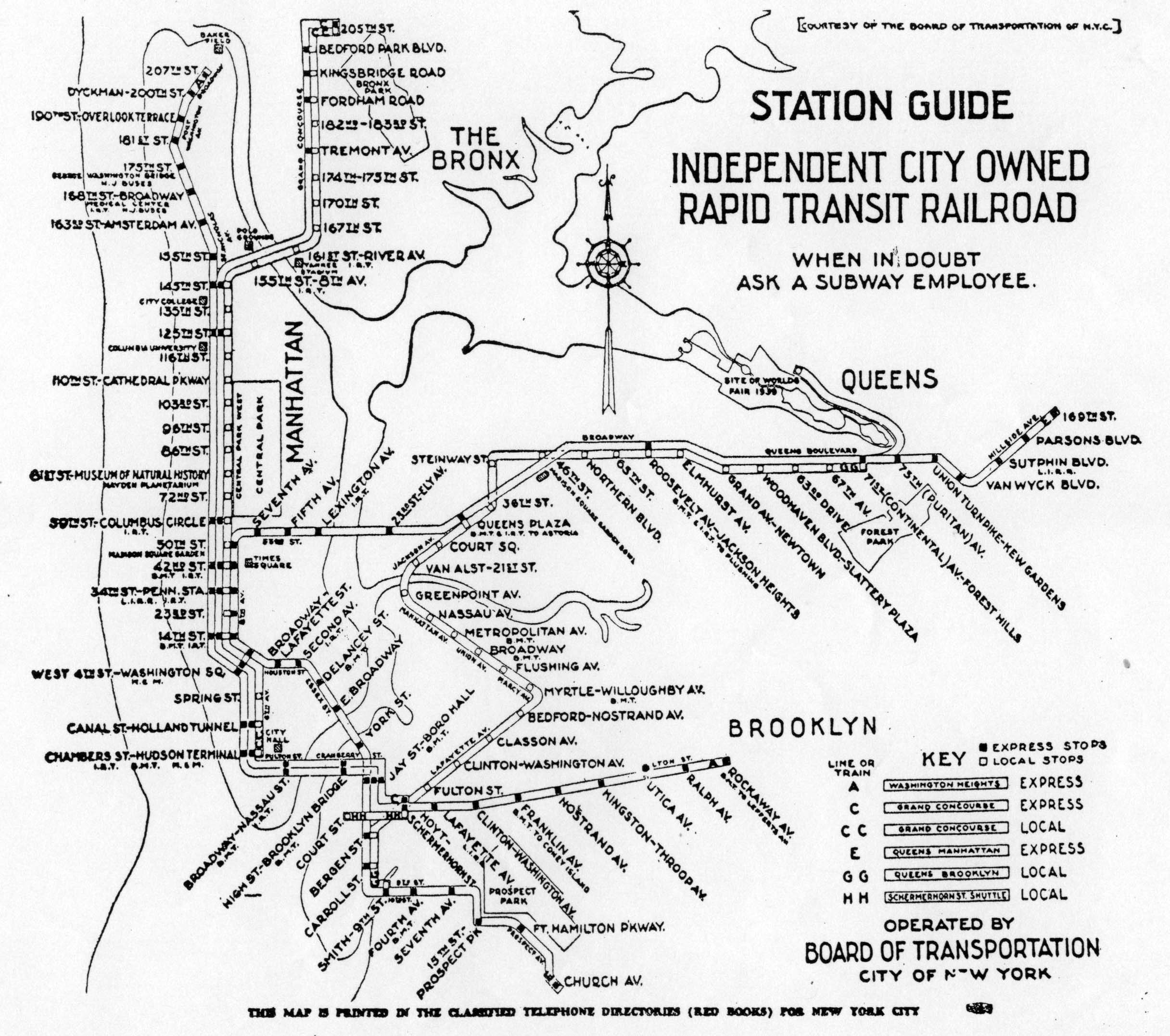
The city built the IND to handle a much larger future city. The Queens Blvd Line was designed to be the central trunk line through the heart of Queens; it would soak up riders in Queens is sift them along 8th Ave, 6th Ave, and Brooklyn via the Crosstown Line. Not only did this help the growth of Queens but it also helped move the central business district from lower Manhattan to Midtown. The trunk-branch design is a hallmark of the NYC Subway as almost all lines run along a trunk subway under major avenues in Manhattan and then branch out into neighborhoods in the outer boroughs. The Queens Blvd Line was built as a reverse-trunk line with its branches splitting in Manhattan and the trunk running through Queens. This was not, however, the original intent as planners designed the Queens Blvd Line as the first phase of a broader plan to have new subways branch off as the farm land developed into residential communities. As the needs of the city changed many of the parts where left behind. There are many places throughout the NYC Subway where provisions were left for future subways that never came to be and the Queens Blvd Line is littered with them.
Crosstown Line
The first segment of the Queens Blvd Line between 50th St/8th Ave and Roosevelt Ave opened August 19, 1933 (not quite year after the 8th Ave Subway was opened). Six days before a segment of the Queens Blvd Line, part of the Crosstown Line, opened from Queens Plaza to Nassau Ave. The first mystery of the Queens Blvd Line is why it was designed with only the express tracks leading into Manhattan and the local tracks led into Brooklyn. Trunk lines in Manhattan at the time (this includes the 7th Ave, Lexington Ave, and Broadway Lines) were designed in such a way where local trains would terminate in lower Manhattan while express trains would continue into Brooklyn. This made sense as downtown Manhattan was the primary destination of most riders and express trains would be able to handle the crowds coming in from Brooklyn or the Bronx. When designing the IND the city took this idea one step further and designed their new subways to only run local trains within each borough while riders needing to get into Manhattan could transfer to express trains (note: this was not the case for Bronx-Manhattan trains as all trains in the Bronx were run into Manhattan, though as designed IND Concourse Line trains, B/D, could terminate at 145th if need be). In downtown Brooklyn what today is the New York Transit Museum was in fact a working subway station, Court St station, that was designed to be the terminal for the IND Fulton St Line (an updated plan called for 2nd Ave trains to connect with it). The IND Fulton St Line was designed to run all the way to the Nassau Co. border so keeping local trains within Brooklyn made sense on paper. When the Fulton St Line opened it only ran with one local train from Manhattan to Rockaway Ave so a shuttle was run between Court St and Hoyt-Schermerhorn Sts stations. Ridership was low and the IND soon scrapped the idea. At Queens Plaza station we can see the shortsightedness of this kind of transportation planning. When it opened the Queens Blvd Line had an express service between 8th Ave and Roosevelt Ave and local service between Roosevelt Ave and Nassau St. As express stations were spaced relatively far apart this forced the majority of riders to transfer at Queens Plaza. As Queens began to develop this proved more and more frustrating.
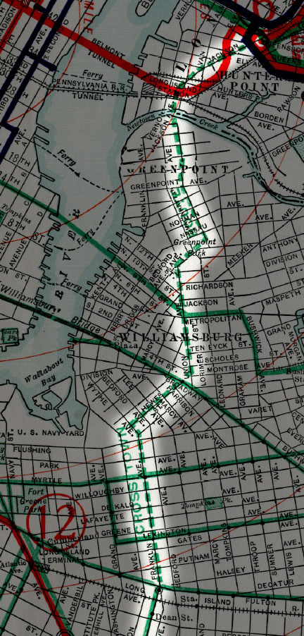
The plan to run Crosstown trains to Queens Plaza was not a new idea. In 1912 the NYS Public Service Committee outlined a number of ideas for new subway lines which included a subway between Brooklyn and Queens. Many different routes were looked at but the one that got the most backing was a new line from Queensboro Plaza station through Greenpoint, Williamsburg, and Bedford-Stuyvesant that connected with the BMT Brighton Beach Line (today’s B/Q trains) via Franklin Ave (which remains as a shuttle today). The major flaw in such a plan was that it was to be built almost entirely as an elevated line. Elevated lines were going up in Queens and in outer parts of Brooklyn but in the densely developed sections of central Brooklyn, home to a number of elevated line already, local residents and leaders wanted a subway or nothing. Because of costs the Brooklyn-Manhattan Transit Co. (which ran the subways and trolleys in Brooklyn almost exclusively) refused to build a subway and there things sat until the new IND declared that it would include a Crosstown Line in its first phase.

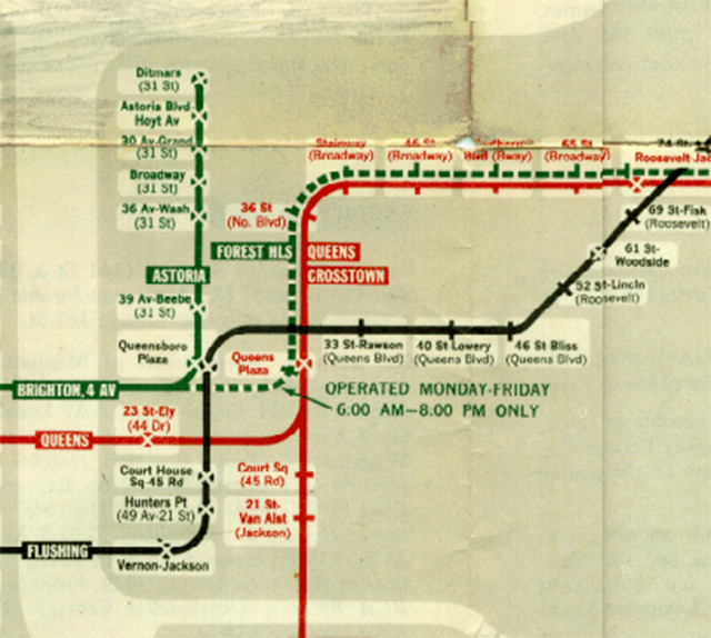
An obvious error today, to have the only local train in Queens not run to Manhattan, but at the time one could argue that the major industrial neighborhoods of Williamburg, the Navy Yard, and downtown Brooklyn seemed just as important destinations for new Queens Blvd riders. Perhaps transit planners saw a more balanced commuter load between Queens and Brooklyn. History tells otherwise as even today the ridership between Queens and Brooklyn is much lower than that between Queens and Manhattan. The IND saw the error of its ways early on and proposed a new connection between the 6th Ave Line and the Queens Blvd Line via a new tunnel under 79th St in Manhattan and Broadway in Astoria. It wasn’t until 1955 and after the city was able to consolidate the private subway companies into a city transit agency when local Queens Blvd trains could run directly into Manhattan via Broadway and the 60th St tunnel; the first physical connection between once completely segregated subway systems. Then in 2001 the 63rd St tunnel was finally connected (more on this later) which allowed a new local train, the V to run, reducing service on the Crosstown Line to nights and weekends until in 2010 it was officially truncated to Court Sq where commuters must make a long trek between stations in order to transfer. The track layout at Queens Plaza station does not allow for Crosstown trains to turn around without crossing in front of trains coming from the opposite direction and as the line is running at capacity any additional Crosstown trains could create delays throughout the system.
Rockaway Branches
Service on the Queens Blvd line was extended from Roosevelt Ave to Kew Gardens-Union Turnpike in 1936 and it is along this stretch where the subway hides its most interesting secrets. From the beginning the Queens Blvd Line was designed to have branches run off the main line as new neighborhoods began to develop. The city saw the need to connect the subway to southeastern Queens amd the Rockaway peninsula which had developed into a summer beach resort get away. The Long Island Railroad ran trains from downtown Brooklyn and Penn Station to the Rockaways but it became less and less profitable to maintain the track viaduct and bridges over Jamaica Bay. The IND had plans early on for capturing this service and designed two different plans for subway service to the Rockaways, building provisions for both into the Queens Blvd Line.

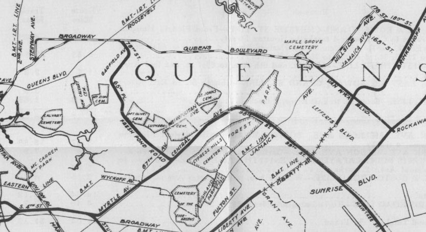
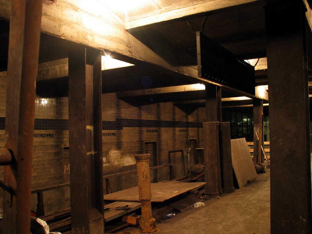
The first plan was to run a rather serpentine route from Roosevelt Ave to Ridgewood and Glendale, Queens, then to Woodhaven Blvd where the subway would run parallel to the LIRR Rockaway Branches to Far Rockaway and 148th St, out to where Jacob Riis Park would one day be built. Keep in mind that because the city was trying to compete with the LIRR the new Rockaway subway was not built along the LIRR right of way, which was eventually bought by the city and incorporated into the subway system, but would have run a few blocks apart. How serious this plan was is up for debate as it seems that such a redundant routing was designed more as a ploy to scare the LIRR into selling the rail line than an actual plan. The IND was serious enough to construct a terminal station within the Roosevelt Ave station with ramps connecting this proposed extension to the existing tracks. The station and platform was built, even having tile work installed, though no tracks were laid. You can see the ramps along the northern wall right before you enter Roosevelt Ave station on a Manhattan-bound train.
The second plan was a more straight forward connection between the Rockaway Branch and the Queens Blvd Line. The LIRR Rockaway Branch split off from the Main Line in Rego Park via a large flying junction (the remnants of which can be seen today). As the Queens Blvd line ran only a few blocks to the north a junction was designed between 63rd Dr and 67 Ave stations which would allow local trains to branch off and run to the Rockaways. These provisions can also be seen from a train built into the outer walls of the subway; supposedly the Manhattan bound track bed rises up and runs above the existing tracks. So serious was the IND that mosaic tile signs can be found along the Queens Blvd Line indicating service to the Rockaways. This second plan would have incorporated a new tunnel between Manhattan and Queens which would have run along 79th St in Manhattan and Broadway in Astoria. It would have connected to the local tracks of the Queens Blvd Line and was the first plan to provide Manhattan-bound local service along Queens Blvd. The new local service would have presumably then ran to 63rd Dr and used the Rockaway Branch.
A new tunnel was eventually built between Manhattan and Queens but due to complications of the geology on the Upper East Side the tunnel location was moved south to 63rd St. When it was connected to the Queens Blvd Line it was designed to service both local and express tracks. Should the Rockaway Branch ever be built it could use the 63rd St tunnel as intended.
42nd St-8th Ave Lower Level

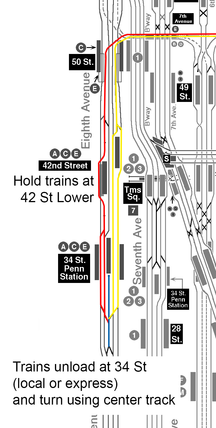
The 42nd St station on the 8th Ave Line was famously built extra large to handle crowds from Times Sq. Later this proved helpful when the Port Authority Bus Terminal opened above. The platforms are so wide that they had to be built staggered: the downtown platform is between 40th and 42nd Sts while the uptown platform is between 42nd and 44th Sts. Additionally a third platform was built below the downtown platform which could only be used by Manhattan-bound Queens Blvd trains, although they never needed to since there was a switch between 42nd St and 50th St stations which allow Queens Blvd trains to access either the local or express tracks. Even more mysterious was that the lower level platform went unused until 1959 when it was put into service for special trains to the Aqueduct Race Track via the newly opened Rockaway Branch Line.
Because no one has been able to find a sufficient reason for the station to be built the popular urban legend was born which stated that because Mayor Hylan loathed the private subway companies so much (which is an actual fact) he designed the IND subway to compete and obstruct the existing subways wherever he could, including at 42nd St where the lower level platform was supposedly built only to obstruct any extension of the IRT Flushing 7 Train to the west. While this is an entertaining story it falls apart once you start to look at the facts. Firstly, while the IND is famously overbuilt, there are no other instances of this kind of overbuilding specifically for spite. Any provisions built by the IND were done so with future service in mind. Secondly, the IRT had no serious plans to extend the 7 train to the west. It wasn’t until Mayor Bloomberg tried to bring the Olympics to New York that anyone saw a reason to extend the 7 train west. The eventual Hudson Yards extension did in fact have to cut through the lower level platform so the space can never be used as anything other than storage.
After studying the track map for the IND 8th Ave Line I came up with a theory that this lower level platform was actually built for a future train service to Rockaway or Jamaica via the Queens Blvd Line. As planners didn’t really know at the time what kinds of service would be needed on the new subway they probably made an assumption that some trains would need to be terminated in Midtown either at rush hour or late night. This isn’t all that impossible to imagine since the bulk of the 8th Ave Line was designed to serve the Upper West Side, Harlem, Washington Heights, and the Bronx. Since Queens was much less developed they may have assumed that most of the traffic would be coming from uptown and that Queens trains might have to be held or turned back at 42nd St.
A close reading of the track map between 50th St and 34th St stations reveals how such a service could have been run and why the lower level platform was built in the first place. If a Queens Blvd train was to be turned around in Midtown it would need to do so after serving the two most important stations, 42nd St-Times Sq and 34th St-Penn Station. The lower level platform allows trains to be held until there is room to run the train to 34th St. The switch set up is designed to allow these trains to use either the local or express track at 34th St and south of 34th St there are switches that lead to a central 5th layup track which is accessible from either the local or express tracks. The trains would wait on this track as the motormen switched sides and sent the train back to Queens. As there are a lot of moving parts to such a plan it may have made sense to do this when traffic was lightest. In all plans for Rockaway service there has always been a shuttle train for late night service: today it runs between Rockaway Park and Broad Channel but plans existed for a terminal at Cross Bay Blvd on the unbuilt Fulton St Subway extension and at Roosevelt Ave Terminal (discussed above). It is very possible that the lower level platform at 42nd St station was an additional terminal for Rockaway shuttle trains.

As IND planners envisioned Rockaway service to be run via Queens Blvd and not through Brooklyn there is no terminal platform on the uptown side of 42nd St. When the Rockaway Line was finally connected to the Fulton St Subway the lower level of 42nd St became useless. This is why the Transit Authority finally activated the platform for service to Aqueduct in 1959 (lasting until 1981).
Woodhaven Boulevard station
Because the provisional junction between 63rd Dr and 67 Av stations is only on the local tracks planners designed an ingenious trick should the Rockaway Branch ever be built. Woodhaven Blvd station lies in the middle of a long stretch of local stations between Roosevelt Av-Jackson Heights and 71 Av-Forest Hills. Because of the distance it was thought that one day there would need to be an express station at Woodhaven Blvd. So subway builders designed the station to be expanded from a local to an express station by building space along the track bed before and after the station to route local tracks around the platforms. It takes an educated eye to notice the difference in platform design to see how the station could be upgraded. Most local stations along the Queens Blvd Line only have a few strategically placed stairs from platform to mezzanine but Woodhaven Blvd station has many more and spaced as they would be in an express station. The walls of the platforms would be demolished and the platform extended out so that the side platforms then become island platforms. This was done again later when the city built the Chrystie St Connection so that the Grand St station could be expanded when the 2nd Ave Subway was constructed and at the Lexington Av-63rd St station on the F which is currently being expanded for 2nd Ave service (though when this station was built tracks and platform were actually built and closed off by a false platform wall.)
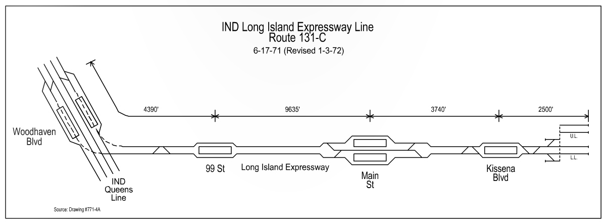
With the growth of eastern Queens after World War II and the connection of the Rockaway Branch to the IND Fulton St Line planners shifted their thinking about Woodhaven Blvd and designed a new branch that would run along the Long Island Expressway. Robert Moses famously designed his highways so that rapid transit could not be integrated, much like how the subways in Chicago run along the medians of their highways, but building along side the highway also had the benefit of offering less intrusive construction. In 1968 (the year Moses was deposed from power and the MTA was created) the city released a wide ranging plan for the entire city and included was a branch of the Queens Blvd Line from Woodhaven Blvd to Main St and a second phase that would extend it east to Springfield Blvd. Subway service had been proposed along Horace Harding Blvd as far back as 1929 but this was the first time it was proposed as a Queens Blvd service.
I have not read any specifics as to why the LIE branch was not built but it is safe to assume that it was cut back along with many of the other 1968 proposals during the fiscal crisis that hit the city in the 1970s. Additionally the land through which the LIE runs through in the area just north of Queens Blvd, especially where Lefrak City was built, is home to an underground spring that historically fed into the Flushing River through Flushing Meadows Park (before it was totally re-engineered for the 1939 World’s Fair) and has a high water table. The high costs of reconfiguring Woodhaven Blvd station and building the new tunnel would have likely doomed the whole project when money dried up.
Superexpress and the Southeast Queens Lines
New subway service to southeastern Queens and Jamaica has been included in every subway plan since the 1920s when existing elevated lines were extended from Brooklyn into Queens. The area became one of the first areas to develop in the suburban pattern after the war as it was served well by LIRR and later new parkways and highways. In the 1920s much of this area was still farm land or subdivisions waiting for new homes; because of the high water table the new subways planned were all either extensions of elevated trains or would run above grade on separated rights of way. Elevated trains were vocally opposed and due to a lack of funding no land was reserved for rights of way. The area quickly developed and left little room for affordable subway expansion.
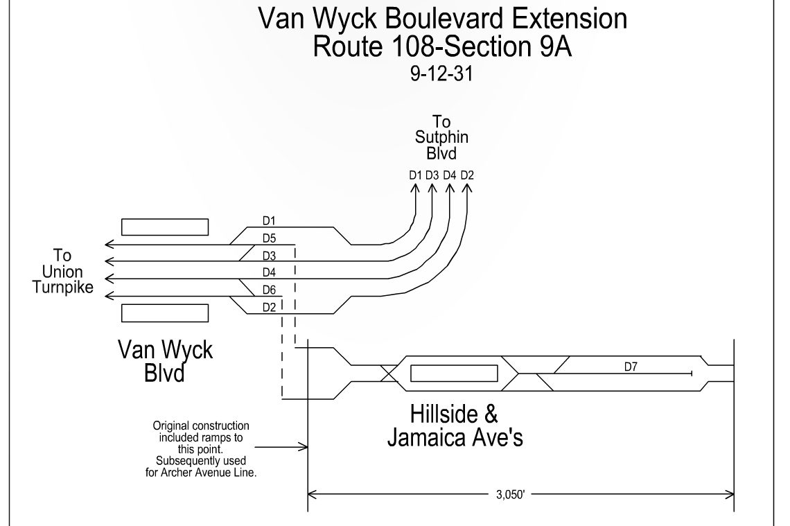
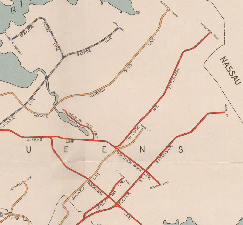
IND planners knew the need for future service in Jamaica and designed the Queens Blvd Line to be expanded east and south as Jamaica developed. Where the Queens Blvd Line turned east under Hillside Ave they designed and built a junction so that local or express trains could continue south along Van Wyck Blvd. Originally the Van Wyck Branch would have run 2 tracks south to Rockaway Blvd where it would connect to a planned extension of the Fulton St Line running east out to Springfield Blvd. Neither extension was ever built and hopes were finally dashed when Robert Moses built the Van Wyck Expressway to Idlewild Airport (soon to be JFK Airport) and left no room for a subway line.
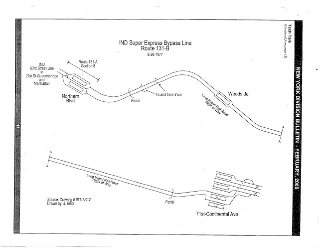
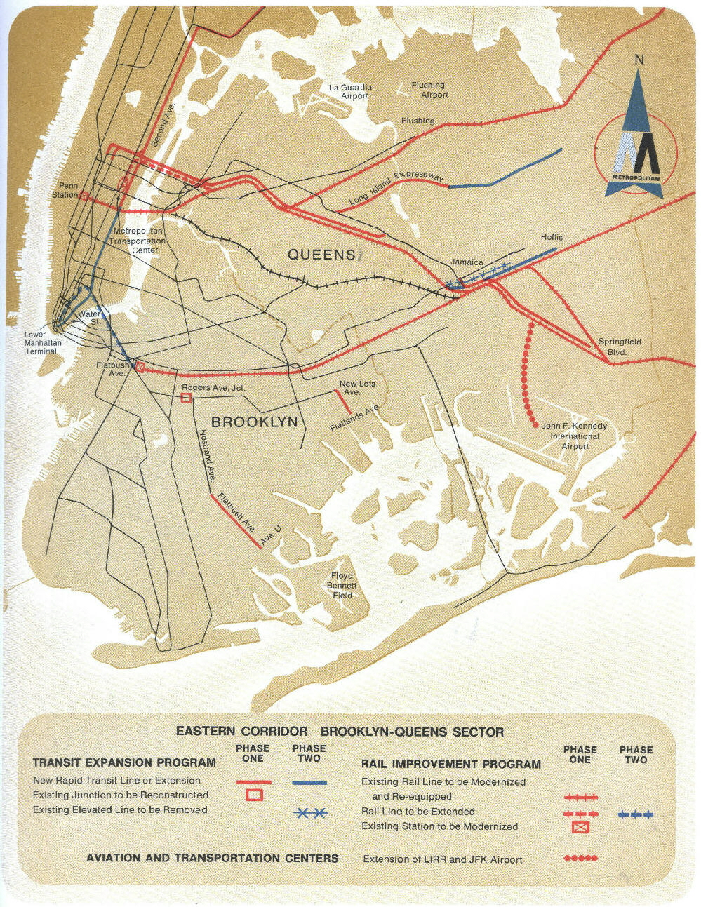
By the 1960s it was clear that improved rapid transit service was needed for Jamaica and in 1968 a grand scheme was proposed for a new superexpress service to Jamaica that would also relocated the elevated trains that ran along Jamaica Ave into a new subway tunnel with extend service to Hollis and Laurelton along side of the LIRR tracks. Planners wisely used the Van Wyck provisions on the Queens Blvd Line and extended the new subway through Jamaica center via Archer Ave. The new bi-level subway had trains on the upper level running via Queens Blvd and the lower level via the BMT Jamaica Line. Both lines were meant to be extended; the Jamaica Line was to head east to terminate at Hollis and the Queens Blvd Line makes a curve to the south and was intended to be extended along the LIRR Atlantic Branch ROW (which would have been converted from LIRR to subway operations) to Springfield Blvd in Laurelton.
Due to the fiscal crisis the superexpress tracks from the 63rd St tunnel to Forest Hills were dropped but construction was completed on the Archer Ave Subway, though this ran into its own share of issues involving shoddy concrete. The Archer Ave Subway opened in December 1988, 20 years after it was first proposed. Because the subway was cut back to terminate at Jamaica Center/Parsons Blvd additional layup tracks and switches were never built. This constrains service and requires the E train use the Hillside Ave Subway for additional runs during rush hour.
Hillside Ave
The Hillside Ave Subway is the last section of the original Queens Blvd Line to be built. The section of the Queens Blvd Line from Kew Gardens to 169th St opened in April 1937 but due to a lack of funding it was not extended further until December 1950. This created operational limitations as 169th St station was only a local station. Some trains would then have to terminate at Parsons Blvd, an express station. As Jamaica developed the line saw large ridership growth from new bus routes coming in from the east. The city was finally able to address the issues and built a new terminal at 179th St which could service both express and local trains as well as a new underground, bi-level storage yard to the east which even today gives the entire Queens Blvd Line the ability to store and turn trains to allow for running trains at one minute intervals. Interestingly, the 179th St station has the most number of egress points of any single station in the system; 16 in total.
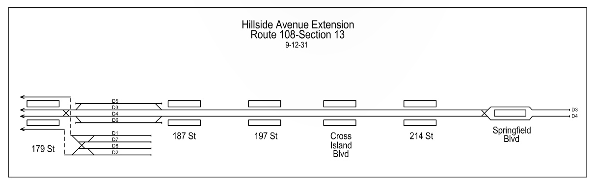
The 179th St extension was only the first part of what was expected to be a longer extension. The local tracks at 179th St lead to the storage yards but the express tracks were designed to be extended further east. Initial plans called for a 2 track subway under Hillside Ave out to Little Neck Road. It is said that the extra wide median along Hillside Ave at Springfield Blvd was left to allow construction of either additional storage tracks or possibly a portal so that trains would run elevated out to the Nassau Co. border.
World’s Fair Line
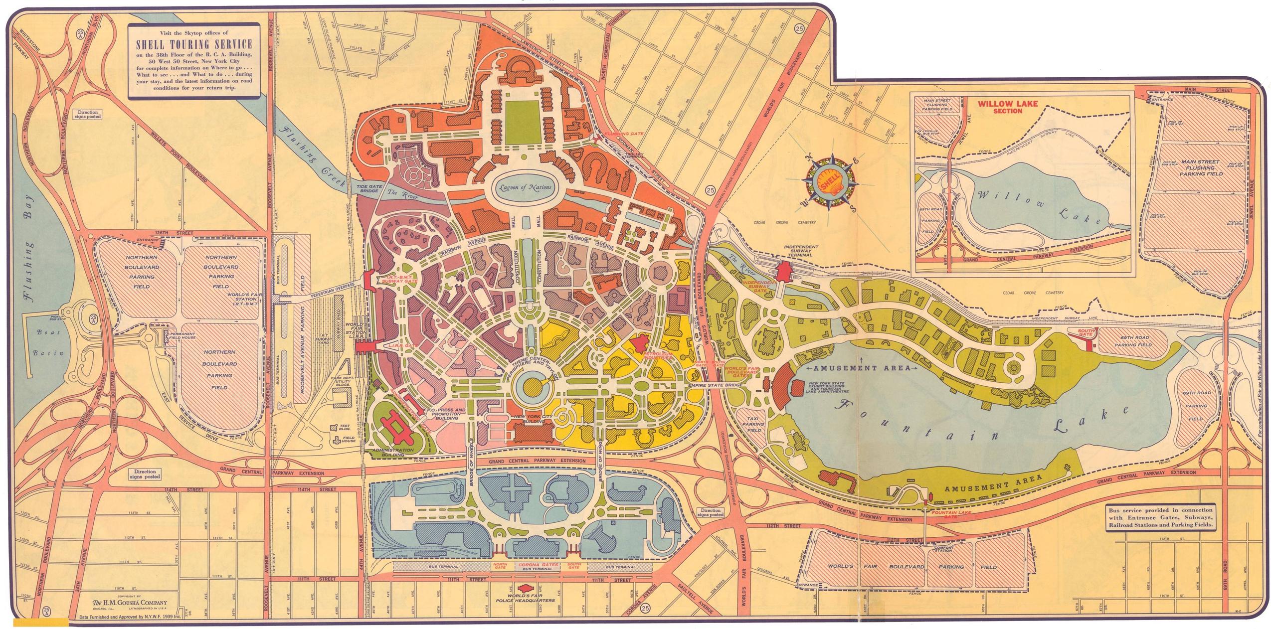
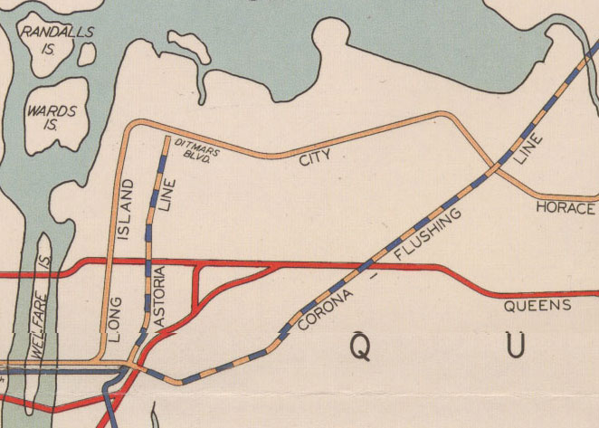
The World’s Fair Line was a temporary shuttle which ran from 71 Av-Forest Hills to the 1939 World’s Fair via the IND Jamaica Yards at Kew Gardens. The tracks bypass 75 Av and Union Turnpike stations and leave a portal along side the Grand Central Parkway to the yards. The branch ran along the eastern edge of the park along a right of way which is now occupied by the Van Wyck Expressway. There were 2 tracks until the terminal station (the only station on the line) just south of Horace Harding Blvd. The shuttle only ran for a year while the Fair was going on. The IRT/BMT also had service to the Fair via the Flushing Line, as well as the LIRR via the Port Washington Branch. Both of these stations still exist at Willets Point Blvd but the IND removed the shuttle after the Fair. Local politicians argued to keep the line as additional service for Flushing but because it was designed to be temporary the line would have had to be completely rebuilt and because the line ran along a park and cemeteries, because any service to Flushing would have had to run via Forest Hills before it went to Manhattan the IND didn’t see it as having high enough ridership to justify keeping the line.
The portal to the Jamaica Yard is still in operation and because it is accessible from both the east and west this means that any future service along Union Turnpike or as a shuttle between Flushing and Jamaica could be designed to use these portals. No official proposals to use the portals have ever been made as far as I can tell. This may have more to do with the neighborhoods along Union Turnpike being less dense than those along the LIE so any future Queens subways would be more effective further north.
The Map
I’ve drawn a map on Google Maps with all the built, unbuilt, proposed, and provisional parts of the IND Queens Boulevard Line. Many of the provisions can be seen from trains running along Queens Blvd.
I am not sure if you have ever seen this, but I thought that this would be of interest. I have found documentation to show that the widening of Hillside Avenue at Springfield Boulevard was definitely for the subway. I was looking on worthpoint for old subway items sold on ebay in years past, and I stumbled upon these great images or original blueprints from 1931. I will post the links below.
https://www.flickr.com/photos/127872292@N06/21685311678/in/photostream/
https://www.flickr.com/photos/127872292@N06/21846988536/in/photostream/
https://www.flickr.com/photos/127872292@N06/21873145625/in/photostream/
Interesting also that they proposed a depressed roadway. It would have turned Hillside Ave into a real highway.