
The borough of Queens came late to rapid transit development. Even after Queens was created out of Nassau County when New York City consolidated into five boroughs it remained farmland well past World War II. Some areas did grow thanks to the introduction of railroads, the Rockaways had summer resort communities. Some early railroads cut through Queens to serve already established towns like Flushing and Jamaica and some were built as real estate ventures that went bust, but by the turn of the 20th Century all of these had been consolidated into the Long Island Railroad or been abandoned. Queens began to develop after transportation improved with the opening of the Queensborough/59th St Bridge and the construction of the Steinway or Belmont Tunnel which allowed elevated and subway trains to be built to Astoria and Corona. A well repeated fact is that the first radio advertisement ever was for new garden apartments in Jackson Heights which were built after the Corona Subway (todays Flushing 7 Line) opened up the countryside.
Planners knew that Queens would eventually grow with development and as neighborhoods like Jackson Heights and Forest Hills began to pop up the need for improved rapid transit also grew. When the city built the IND Queens Line along Queens Boulevard it was designed to be the major trunk subway which future new lines would connect with to reach Manhattan. New connections were planned to Jamaica and Far Rockaway. A new subway was also being considered along Horace Harding Boulevard which would run through central and eastern Queens. Because much of the area was still farmland the subways could be built cheaper than waiting until the area was developed.
After World War II development shifted along with new transportation technologies, the car and the truck. With developers no longer needing to wait for subways to build their homes the farmlands of Queens filled up quickly. Robert Moses famously built his highways to exclude mass transit. The subways planned along Horace Harding Boulevard and Van Wyck Boulevard instead became the Long Island Expressway and the Van Wyck Expressway. Instead of a dense urban development pattern seen in the Bronx or Brooklyn, Queens embodied the new suburban sprawl development that was quickly changing the fabric of the entire metropolis.

Many of the proposals I’ve talked about previously in this series have looked at subway expansion along existing lines or new subways to replace older, out dated service. Because Queens developed around the car and not the train the new subways through Queens will have to be designed differently than in older areas of the city. I’ve already talked about the Myrtle Ave/Union Turnpike Subway which would service central Queens, and I’ve also talked about expanding the Second Ave Subway into southern Queens and Jamaica. Now I want to look at the last section of Queens, northern Queens and Flushing where a third and final new trunk line subway will knit the farthest reaches of the borough into the subway network.
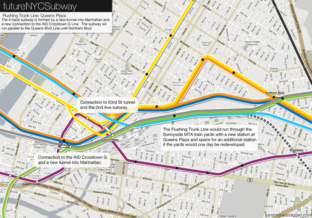
The Flushing Trunk Line begins in Long Island City. In the last post I talked about a new Manhattan crosstown subway which would run into Long Island City and connect with the existing IND Crosstown G Line. Because the existing Queens Blvd Subway is already at capacity a new 4 track subway, the Flushing Trunk Line, would be built parallel to Queens Plaza with 2 tracks serving Manhattan trains and 2 tracks serving a rerouted IND Crosstown G Line. The actual subway would be constructed inside the Sunnyside railroad yards which is owned by the MTA. A second station would be built at Queens Plaza serving the Flushing Trunk Line with a free transfer to the Queens Blvd Line.
Just past Queens Plaza a new connection will be built to allow trains using the 63rd St tunnel to access the new subway. On the map to the right there is a station inside the Sunnyside Yards. Over the years there have been many plans floated for air rights development over the yards (much like the Hudson Yards and Atlantic_Yards) but ultimately nothing has ever been built. This station may be built as a shell at first in anticipation for future development. At the end of the yards the subway will split with 4 tracks running under Northern Boulevard and 2 tracks running under 37th Ave. The tracks under 37th Ave will be the first section of a super-express subway out to the Rockaways and will go as far as Broadway-Roosevelt Ave. After Roosevelt Ave the super-express line will head south along 78th St until it reaches the Long Island Railroad tracks at which point it will surface and run to the Rockaways along the abandoned LIRR Rockaways Line (see my previous post about a Second Ave Subway super-express subway).
Northern Boulevard and Alternatives
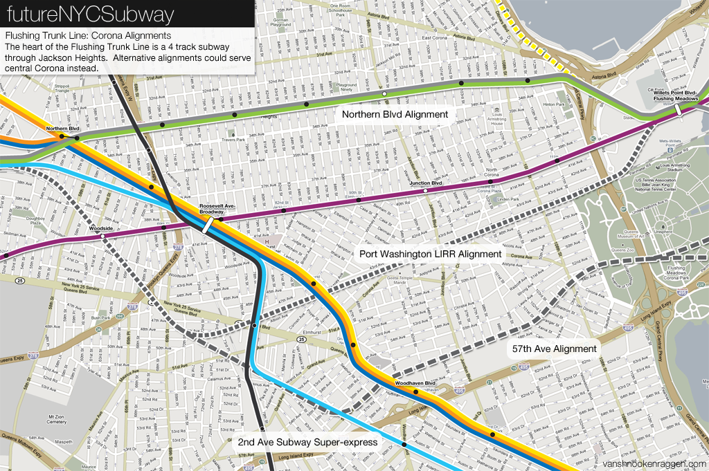
Northern Boulevard is a major highway through northern Queens (it runs out along the north shore of Long Island as NY25 all the way to the tip of the north fork at Orient Point). Because it cuts through such a substantial section of city and is wider than other avenues in Queens it makes the perfect route for a new subway. The Flushing Trunk Line would make a straight shot down Northern Blvd with one express station at Junction Blvd (this station would be specially designed for travelers transferring to shuttles to La Guardia Airport). The subway would snake south at 114th St where it would meet up with the existing station at Willets Point Blvd serving Citi Field, Flushing Meadows Park, and the National Tennis Center. Here will be a major transfer station as it also serves the LIRRs Port Washington Line. After this point the subway splits into two branches.
Though Northern Boulevard would be the preferable alignment there are two other options which would serve other parts of central Queens which at present the subways only skirt. Central Corona used to have two commuter rail stations on the LIRR Port Washington Branch but these were taken out of service decades ago (Corona Station in 1963 and Elmhurst Station in 1985).
A Port Washington Alignment would run a branch of the Flushing Trunk Line along the Port Washington Branch right-of-way, splitting from the trunk line in the Sunnyside Yards so that it would run through Woodside before turning east into Corona. Another branch would run along Northern Boulevard and at Willets Point Blvd both branches would meet up before splitting again in Flushing. The right-of-way along the Port Washington Branch would not be wide enough for subway and commuter rail tracks. Either eminent domain would be needed to take buildings along the tracks or the Port Washington LIRR Branch would have to be totally converted to rapid transit (neither are preferable options).
The southern most alignment would run along 57th Ave. This alignment would go further in reaching under served areas of Queens but would have to contend with tight, winding, narrow streets. Transit planners knew that this area would require mass transit at some point and began studying ideas for extending subway lines along Horace Harding Blvd as early as 1929. Horace Harding Blvd was expanded by Robert Moses in the 1950s and 1960s to create the Long Island Expressway. He ignored the cries of planners when he neglected to provide room along the median of the expressway for a future subway line. The 57th Ave alignment would serve this same area but would be better integrated into the fabric of the city. Subways built along highways are less expensive but require pedestrians to traverse a rather inhospitable landscape to reach them. A subway built under 57th Ave would be better for pedestrians and businesses along the avenue and would not require taking a travel lane out of the Long Island Expressway (either permanently or during construction).
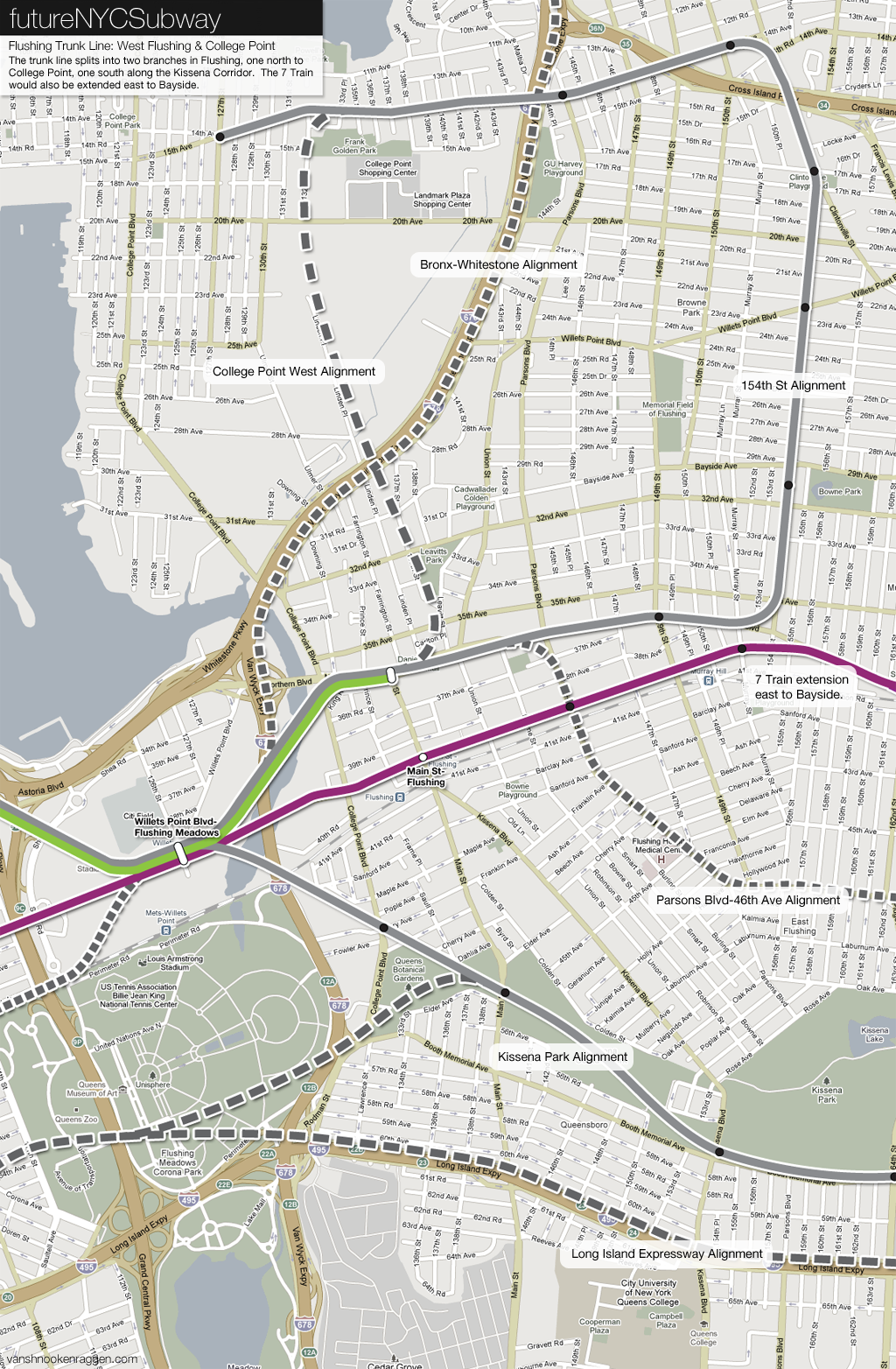
The Flushing Trunk Line splits after Willets Point Blvd and becomes two, 2 track subways, one north to College Point and one south to Auburndale and Oakland Gardens along the Kissena Park corridor. The Flushing Trunk Line proposal also calls for the extension of the 7 Line east to Bayside. This extension has been proposed as far back as 1929 and also included a branch to College Point (I’ve incorporated this branch into the new trunk line).
College Point and Whitestone once had a rail connection to Long Island City with a branch off the LIRR Port Washington Branch just past Willets Point (a great write up about the Whitestone Branch over at ForgottenNY). The old line ran up to College Point near 130th St, turning east along 11th Ave to the docks in Whitestone. The line was abandoned in 1932. The city at one point tried to buy the right-of-way for rapid transit conversion but no deal was ever finalized and the right-of-way was eventually sold and built over.
The modern College Point subway would continue down Northern Boulevard to 154th St where it would make a 90 degree turn north up to 14th Ave in Whitestone where it would make another 90 degree turn back west, creating a giant “hook” shape, out to 127th St in College Point. This is pretty close to the original proposal by the city in the 1930s. This alignment would serve more residential areas than the original, western alignment which would run along or through the old Flushing Airport (closed in 1982), now mostly soggy abandoned marshland. A third alternative would be to run the subway along the Whitestone Expressway at grade. While this alignment would not serve as many neighborhoods as the 154th St Alignment, it would be less costly and would have the space for large parking facilities along the highway. It would also allow for possible extension of the subway across the Bronx-Whitestone Bridge, something I talk about in the next section.
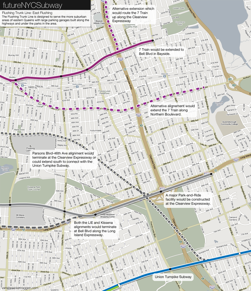
The 7 Train extension west would be a 2 track subway under Roosevelt Ave to the point where it reaches Northern Boulevard. Here the subway has three alternatives, the first would be to continue under Northern Boulevard to Crocheron Ave and continue west under 35th Ave to Bell Blvd in Bayside. The second would be to have the subway, after Northern Boulevard, run at grade along the Port Washington LIRR Branch out to Bell Blvd (where the existing Bayside LIRR station is). The final alignment would have the subway run entirely under Northern Boulevard out to Bell Blvd.
The second branch of the Flushing Trunk Line would make a quick turn southeast after Willets Point Blvd. Like College Point, this area too once had a railroad running through it that was eventually abandoned, the Central Railroad of Long Island, the right-of-way for which was redeveloped as the Kissena Park corridor. The southern branch of the Flushing Trunk Line would follow closely this alignment. The subway would run under the park making construction much cheaper and less disruptive. An important feature of this proposal are large underground parking garages. Eastern Queens is much more suburban than other parts of the city and any subway expansion into Queens needs to take this into account. This part of the city did not develop around walking, elevated trains, or streetcars like much of Manhattan, Brooklyn, or the Bronx, and because of this it wouldn’t work to build a subway without adequate parking. The park space is perfect because when construction is complete the park will be restored and no buildings would need to be taken. The eastern end of the branch would run along the Long Island Expressway to Bell Blvd.
An alternative to the Kissena Park corridor would be to run the subway under Parsons Blvd to 46th Ave to Hollis Court Blvd. This alignment would run through residential and smaller commercial areas and would not serve drivers with large parking garages like the park plan would. Both alternatives could also be extended south along the Clearview Expressway to meet up with the Union Turnpike Subway which I proposed in a previous post.
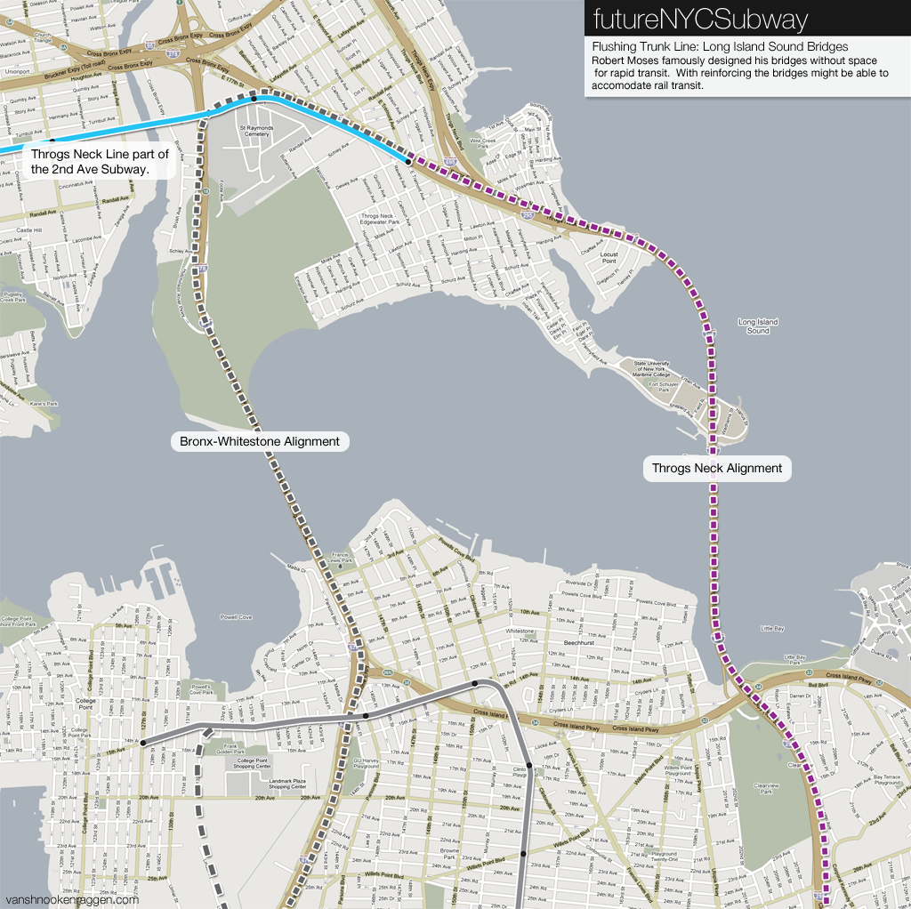
Like his highway, Robert Moses left no room on his bridges for mass transit. When we was planning his bridges between Queens and the Bronx planners begged him to provide space for mass transit but he refused. Because of his hard-headed short sightedness the only way to get between eastern Queens and the Bronx is by driving, taking a bus which is caught in the bridge traffic, or by taking the subway into Manhattan and back out.
At first it might not make much sense to connect the Bronx and eastern Queens, an expensive option since neither places are large employment centers with central business districts with their own traffic patterns. But a subway connection would offer an alternative and faster ride into the city for residents of the eastern Bronx. Presently there is only one subway, the congested 6 train and 6 express, at rush hour, serving this large area. Express buses pick up the slack but are forced to sit in rush hour traffic. The most congested sections of the NYC Subway are along the Lexington Ave Line to the eastern Bronx. Even with a Second Ave Subway, residents of the eastern Bronx won’t have much of an improved commute (the current plan for the Second Ave Subway does not even extend into the Bronx).
A subway over one of the East River/Long Island Sound bridges would be a great improvement for commuters. Large parking garages could be built along the highway or under interchanges where today there is just vacant land or parking lots. Trains would collect commuters who might otherwise be stuck on the Bruckner or Cross Bronx Expressways and whisk them into midtown Manhattan via Flushing and Long Island City. This would take considerable pressure off the Triboro/RFK Bridge and FDR Drive as well as the Lexington Ave Subway. An added benefit to such a connection would be that travelers headed to La Guardia Airport would have a better mass transit option than driving through Manhattan or in Queens.
The two options for a bridge alignment would be as a branch of the Flushing Trunk Line (which would be faster into the city with fewer express stations) or an extension of the 7 Train (slower with rush hour-only express trains). Either bridge, the Bronx-Whitestone or the Throgs Neck, would need to be retrofitted or replaced for this to be possible. It is this fact which makes subway expansion over the bridges less attractive. However, at some point in the future these bridges will need to be replaced. Knowing this, I am not proposing that the city actively plan on extending subway service over these bridges now but only prepare for the eventuality and correct the mistake Moses forced on the city when he built the bridges. Much like the planned replacement Tappan-Zee Bridge across the Hudson, space would be provided on a new bridge for mass transit (bus, light rail, heavy rail, or commuter rail).
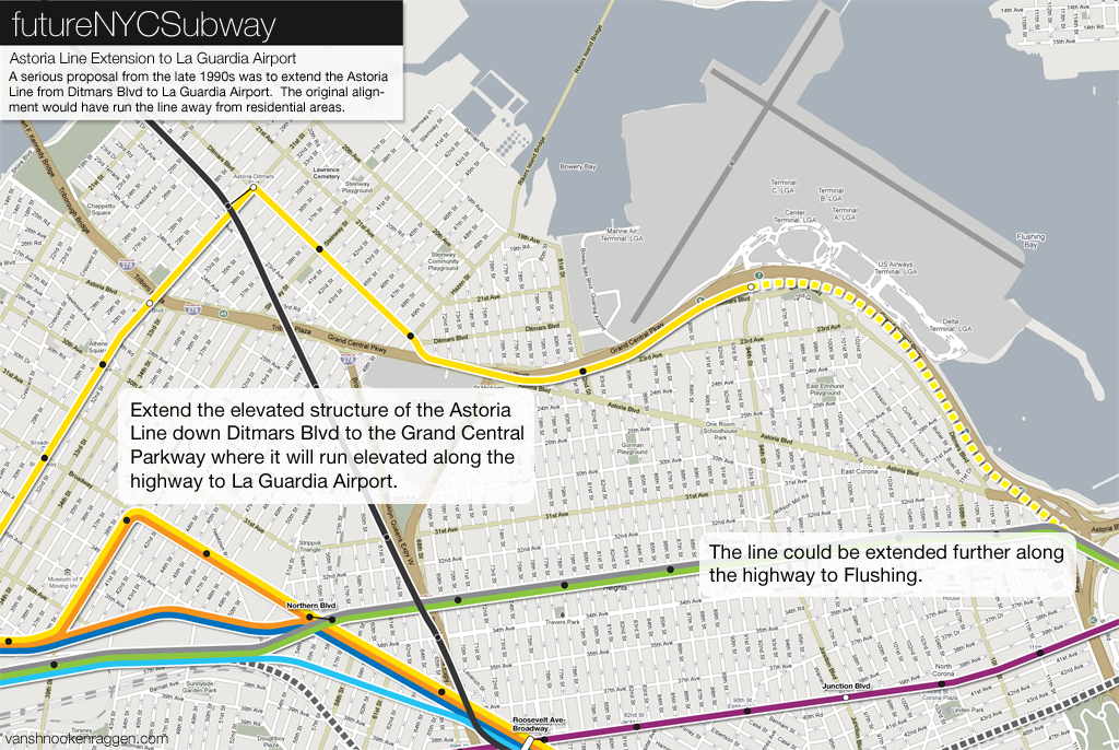
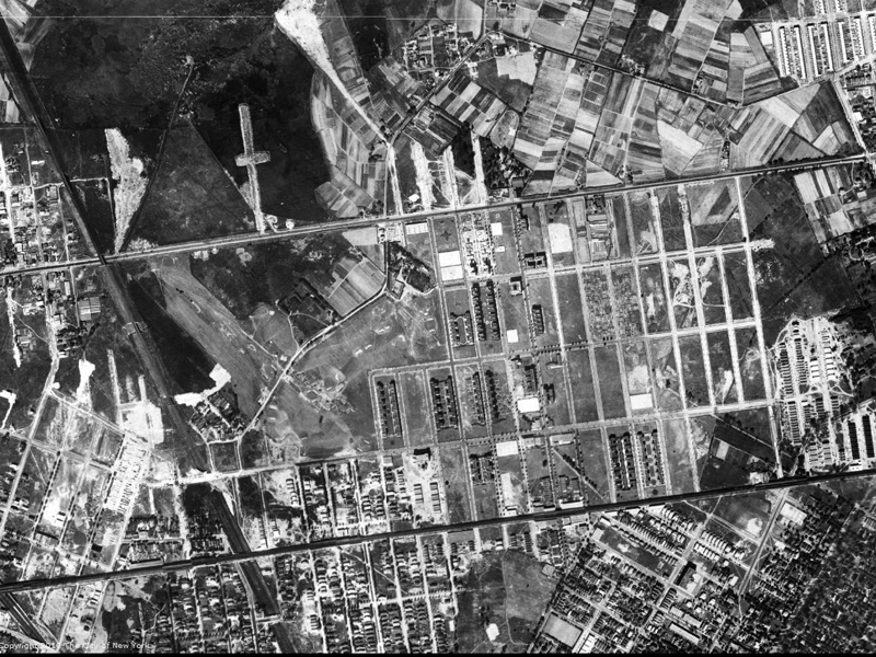
An extension of the elevated BMT Astoria Line (N/Q trains) east is much less far fetched as it sounds. In the original 1929 IND Second System plan the Astoria Line was to turn east at Ditmars Blvd (the current terminal) and wind its way through Elmhurst to Horace Harding Blvd (now Long Island Expressway). The area at the time was still largely undeveloped (see the picture of Jackson Heights at the top of this post) so an elevated line extension would not have caused much of an uproar (on the contrary, land owners at the time were fighting for improved transportation). Like the rest of the Second System this extension never came to fruition.
As recent as the late 1990s, however, the idea was floated again as a way to reach La Guardia Airport. At the time the city was looking at ways to connect mass transit to JFK and La Guardia Airports. Many ideas were floated, an automated light rail system was proposed to connect both airports with subways and commuter rail (but was only built out for JFK as the AirTrain), an extension of commuter rail from JFK into downtown Manhattan, and an extension of the BMT Astoria to La Guardia.
The Astoria Line extension proposal had the elevated subway extended north along 31st St to 19th Ave (which is not an actual intersection because this land is owned by ConEdison and is not a street), turning right along 19th Ave where it would travel to a new terminal located near the La Guardia Marine Air Terminal. This alignment would have avoided most of the residential areas and run through a mostly industrial neighborhood to reach the airport. The proposal, which was very seriously considered, was shot down by residents who didn’t want the elevated trains running though any more of their neighborhood.
The map at the right shows a slightly altered proposal for extension, one that is closer to the original 1929 plan. Here the Astoria Line would turn at Ditmars Blvd and run down to the Grand Central Parkway. It follows the parkway, elevated, up to the La Guardia Terminals with stations at Steinway, Hazen, and 82nd streets (the 1990s MTA proposal had no additional stations besides the La Guardia terminal). The subway could be extended further east to terminate at the Willets Point-CitiField station so that travelers coming from Long Island could have a mass transit option when going to La Guardia Airport.
Northern Queens is the best served section of Queens in terms of rapid transit today (which isn’t really saying much). But the few subways which run through it are filled to capacity with no space left for extensions further east. Most of the borough is miles from any subway and if there are going to be any more subway extensions to serve Queens then a new trunk line will be necessary. Queens is growing in population and if New York City is to be able to take in an addition 1 million residents in the next 20 years then Queens will have to grow denser than it is today. The only way this will be sustainable is if mass transit is extended out to reach all sections of the borough.
The Flushing Trunk Line is my proposal to address these issues in northern Queens. It would take pressure off of the 7 Line and the Queens Blvd Line at the same time as serving large sections of the city. With the growth of Long Island City as a residential and commercial neighborhood the congestion along the existing subways will just get worse. New capacity is the only sustainable answer to address transportation issues in Queens. This will require new zoning as well and the Queens of the future will be much less suburban than it is today, but then this was always going to be the case. Like when the elevated trains came to the farmlands of old Queens, new transportation will go hand and hand with future transformation. New subways will allow for a denser, more sustainable Queens and could even be a model for how other suburbs around the nation adapt to rising old prices and congestion.
Subway Diagram
The futureNYCSubway
- IND Second System
- Post War Expansion
- The Second Ave Subway: History
- The Second Ave Subway: To The Bronx and the Nassau Line
- Brooklyn: Bushwick Trunk Line
- Manhattan: West Side and Hudson Crossings
- Queens: Flushing Trunk Line
- Staten Island: The Last Frontier
- TriboroRX and Atlantic Ave Super-Express
- Conclusion: the vanshnookenraggen plan
There are a number of places on your map where three services are shown sharing a single pair of tracks, notably Central Park West and the northern part of the Culver Line. Wouldn’t this unnecessarily limit capacity? For example, the A and H trains could not run at full frequency through midtown and along your new East Broadway subway and Grand Street river tunnel because they have to share tracks with the D on Central Park west. This is to some extent a problem for the N/R/W today, and a severe problem for the F today (though your proposal addresses that).
You are right, partially. The Central Park West A/H configuration wouldn’t limit capacity because the A and H trains would be sharing tracks for the majority of their runs; less A trains would be offset by additional H trains. The only places where this would limit frequency would be at the very ends of the lines at 207th St and out in Queens. 207th St is also served by the 1 train so a slight reduction in service wouldn’t necessarily be terrible and at the other end, in Queens, the passenger loads wouldn’t be heavy enough to really warrant full frequency.
The Culver Line is a problem that I just haven’t found a solution to. If the F train was routed along the express tracks then there would be no problem except that this would require passengers getting on the subway at Carrol St, Smith/9th Sts, and 4th Ave to all transfer at Bergen St if they wanted to go into Manhattan (and would make people have to go up and down stairs to do so). This was the death knell of the Culver express service in the first place.
Astounding piece of work. It’s really been thought out. Some of the routes are covered by our surface transportation system (buses). But it would have been nice to have it all flow smoothly underground as part of one subway system. Of course, the capital expenditure would be in the many, many billions of dollars (back then and now), making the chances of this ever happening at zero. It would have been nice to have planned all these very sound expansions during the 1930s when there was a worldwide depression going on and we had a readily available workfoce in the millions (25-30% unemploymnent rate) and a government willing to make the capital investment to put these people to work. I’d like to think that can never happen again, but who knows?
But you have B trains sharing with the A and H on Central Park West as well… if the A and H use the full capacity of a track-pair at peak times, where do the B trains go?
Also, passengers from Caroll and Smith-9th to Manhattan can change at Hoyt-Schermerhorn if the stairs at Bergen St are an issue. Alternately, you could rebuild the junction north of Bergen St to allow your K train to run express on Culver without conflicting with local service.
A/H and B trains could fit at the increased frequency. It would only be for rush times anyway.
Changing at Hoyt-Schermerhorn seems like a worse idea than making people walk up stairs at Bergen St.
The proposal for the #7 Train extension to Bayside is entertaining but there is the simple fact that it isn’t needed and that people in Northeast Queens would vigorously oppose further densification of areas that they have fought so hard and with success to down-zone. The neighborhoods east of Flushing Main Street are served by the best line of the Long Island Railroad, the Port Washington Line and if additional transit capacity is needed then more trains or double decker trains should be added to this line with parking spaces increased at Bayside Station.
I find the extension to College Point and Whitestone interesting and unfortunate. It is unfortunate in that one of the great losses to Northeast Queens was the closure of the Whitestone Division of the Long Island Railroad which had stations in College Point, Malba, Whitestone and Whitestone Landing.
I think people in northern Queens would benefit from these new lines. I would have the #7 train travel to Springfield Blvd. I would extend to N,W train on the 46 street Parsons Blvd alignment.It will be a 4 track line and then go to 2 tracks
toward the terminal at Bell Blvd.
Is it possibe to actually build a 4 track subway tunnel under the Long Island Expressway? I know it has been proposals to run subways the right of way parallel
to the highways.
It would be if it was deep bored since you wouldn’t need to disrupt traffic (too much). The problem is that planners usually route subways along highways so they can be built in the median to save money. The LIE has no space for this so a deep bore would be necessary. At that point it would just make more sense to build a subway closer to where people are and not make them have to go near the highway at all.
Wow, it us great to see that NYC is taking it’s first steps to addressing transit issues in a wider way by considering to extend the 7 into new jersey. I have said thus before, excellent job on your work, i can only hope the mta can get the funding to pull it through.
The extension of the N and W trains to LGA Airport is a good idea. Maybe the lines could extend to follow Grand Central Pkwy and then turn east and into Whitestone Expressway and cross the Long Island Sound Bridges. After crossing the Throgs Neck Bridge,it would follow Clearview Expwy all the way to Grand Central Pkwy and turn east to Glen Oaks or turn west and meets where the line seperated from the expressway, therefore creating a “loop”
In order for the Y train to use the Winfield spur,it has to be on th local tracks. That way it wouldn’t have to switch over at Jackson Heights Roosevelt Avenue.
Many of your proposals make too much sense for them ever to be implemented. That said, let’s deal with goals that are somewhat achievable, such as increasing rapid transit to NE Queens: Is there some way that the PW Branch of the LIRR can be “captured” in the sense of making it into something like the SIR? I.E. no actual physical connection with the IND or IRT, but run more in the subway mould than commuter rail mould? My thought was to build relay tracks east of Bayside station so that trains to and from Manhattan running “local,” as it were, could be turned around faster and provide closer headways. Trains going the whole route to Pt. Washington would operate non-stop to and from Douglaston, unless it were deemed advisable to have a transfer at Bayside. With the East Side access built, it would be determined at that time where the “local” would go, there or Penn Station. I use the word “local” but what I have in mind is more akin to a rail “Express Bus” of sorts, operating on that sort of a schedule with that sort of fare structure, i.e. premium fare and no overnight service. This proposal would be of a piece with other such “captures.” To tie in with the system, a fare control plan would need to be devised but that is probably the least worry.
The port washinton line should be be run as premium subway. The 63rd Street t upper level tunnel has available capacity for 10-14 additional trains per hour (based on a conservative assumed capacity of 26-30 trains per hour)
I would allocate this as:
*2-4 trains per hour serving douglaston – port washington with stops at Flusing and Woodside
*4-6 trains per hour using the rockaway beach line into JFK airport with transfers to the rockaway ind trains
*4-6 trains per hour serving portwashington branch stations from woodside – Bayside and then running over/ in the median of the cross island parkway for stations at:
**Union Turnpike
**Hillside Ave
**Jamaica/Braduct
**Hempstead Ave/Belmont
**Linden Blvd
**Merrick Blvd
These new station would capture a large part of the the ridership who currently transfer from buses from eastern Queens and Western Nassua to the E/F trains and would there by given back capacity to the Queens Blvd IND.
what about run a subway line from flushing down main street to jamaica
It’s an interesting idea. In one of my later FNYCS posts I added a shuttle between Jamaica Center and LaGuardia Airport via Flushing. It would have run along the Van Wyck Expressway which would be cheaper to build but wouldn’t serve the Main St corridor as well. Given the resistance to the Main St Select Bus Service going in I think any subway construction would face even more obstruction so maybe building a subway along the highway would be the better alternative.