
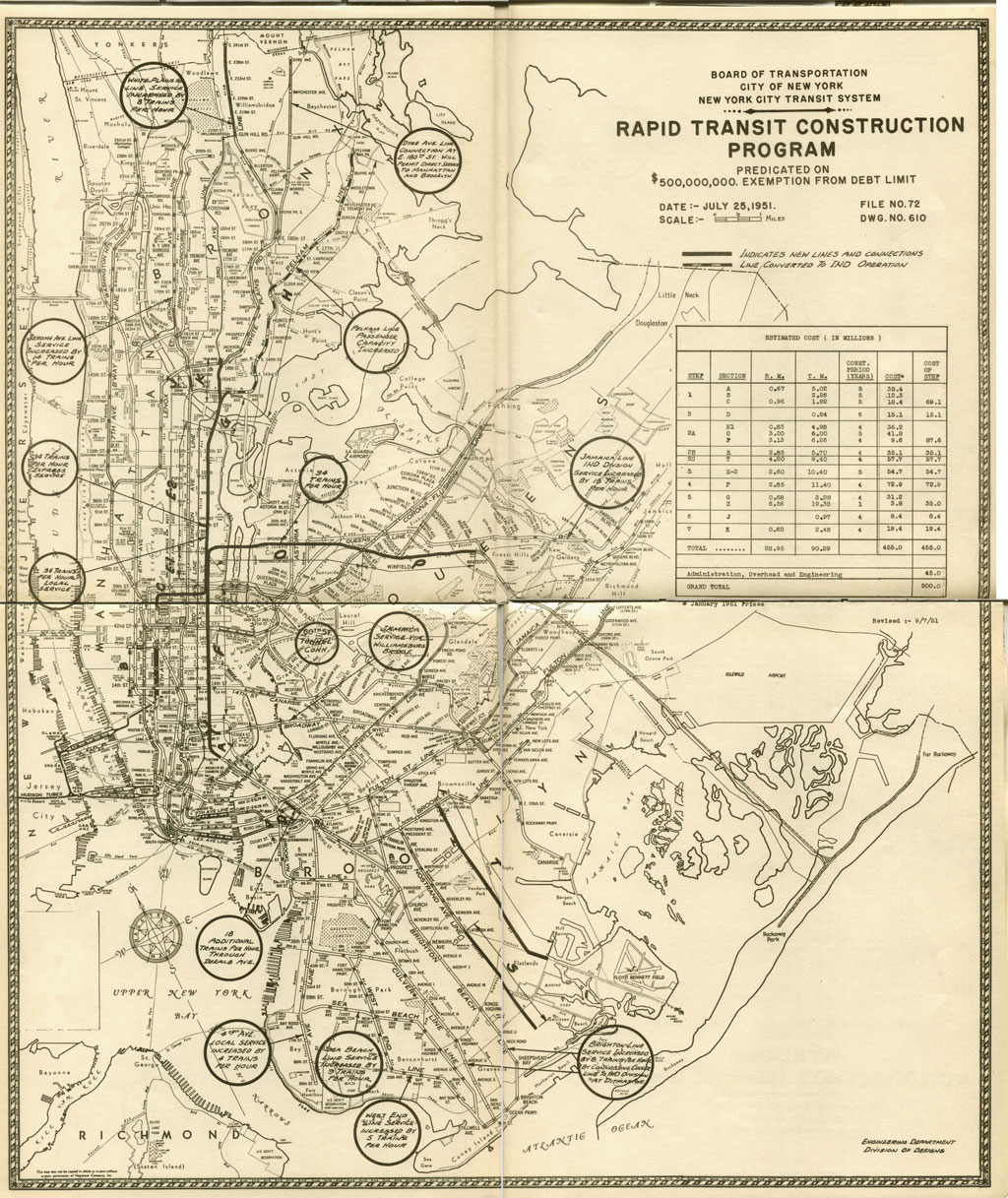
In my last post I outlined the ambitious plan to massively expand the New York City subway system. For various reasons (the Great Depression, World War II, rise of suburbia, etc) the plans were, for the most part, never realized. After World War II many plans were scrapped as limited resources were diverted to building new highways. Plans for the Second Ave subway stayed on the table but were cut back again and again as the years went on (this will be covered further in my next two posts). Some minor expansion took place but the system also lost many miles of track as older elevated lines were removed.
In 1968 the city developed a new, much less ambitious, plan to expand subway service and rebuild aging infrastructure. In an unfortunate case of history repeating itself the city immediately faced a financial crisis causing the plans to be scrapped and subway service to be cut. For the next 20 years the city planned, for the first time ever, to decrease in size and services. It wasn’t until the 1990s, when the population stabilized and the economy of the city began to grow, when serious plans for expansion were brought back.
But just as things were looking up for the city the terrible events of September 11th caused many to fear that these gains were to be temporary and that the city would continue its former population exodus. Due to the resolve of the people of New York and strong political leadership the exact opposite has happened; Today the city has a larger population than at any point in its history and for the first time in decades it is needing to plan for expansion of services and infrastructure. The Second Ave subway, which had broken ground twice in its 80 year history, finally has funding and is well under construction. The same for an extension of the 7 Line to the Far West Side of Manhattan, and the long awaited East Side Access project to bring Long Island Railroad cars into Grand Central Terminal.

The Chrystie Street connection was a small but very significant expansion project that more than any other after World War II changed how the New York City subway was operated and, due to foresight, left the door open for connections to Brooklyn from a still-to-be-built Second Ave subway.
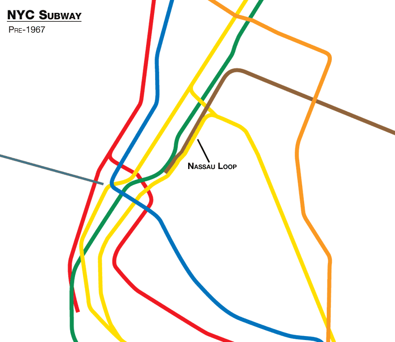
To understand the implications of such a project you need to see what the system looked like before 1967. When the BMT first built it’s subway into downtown Manhattan it did so in 3 parts. The section known as the Broadway line which, as the name suggests, runs under Broadway and then under Church St, runs through the Financial District where it dives under the East River to downtown Brooklyn (today’s R,W line). The second part was via the Williamsburg Bridge, a connection already established when the bridge was completed, with a new subway under Delancey and Centre Streets to a major terminal at Chambers St (today’s J,Z line). With the construction of the Manhattan Bridge, with a capacity of 4 subway lines, the BMT was able to connect the previous two subways with a third over the bridge. One line would use the bridge and head north via Broadway (today’s N,Q line) while the other would use the bridge to head south via Centre St. A new subway under Nassau St would then allow trains to loop from the Manhattan Bridge, through downtown, and back into Brooklyn via the tunnel (this was known at the time as the Nassau Loop).
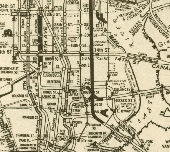
Due to the growth of midtown Manhattan in the middle of the 20th Century, the Nassau Loop soon began to lose ridership and was eventually cut back to part-time service. Planners saw the need to increase service to midtown and saw the tracks on the Manhattan Bridge as underutilized. Elsewhere in the system was a section of subway that was able to increase in capacity, the IND 6th Ave line, recently outfitted with an express track from West 4th St to 34th St. As outlined in the Second System plan, this express track was to be used for trains to Williamsburg but that subway was never constructed. Seeing an inexpensive way to improve service from Brooklyn to midtown Manhattan, the new Transit Authority developed plans to connect the 6th Ave subway to both the Manhattan Bridge and the Williamsburg Bridge with a new subway under Chrystie St in the Lower East Side. A very forward-thinking benefit to this short subway is that it allows further connection to the Second Ave subway so that trains can connect directly to Brooklyn via the Manhattan Bridge. A new station at Grand St is said to have been built to allow 2 additional tracks to be built on the outsides of the platforms when the Second Ave subway is constructed. This new connection allowed for more trains to travel from southern Brooklyn to midtown and also allowed for direct service from northern Brooklyn to midtown. The latter service, known at the time as the “K” train, was only used for a few years due to rapid depopulation in neighborhoods in northern Brooklyn (I talk about the possibility of bringing this service back in an earlier post).
63rd St Tunnel and Archer Ave Subway
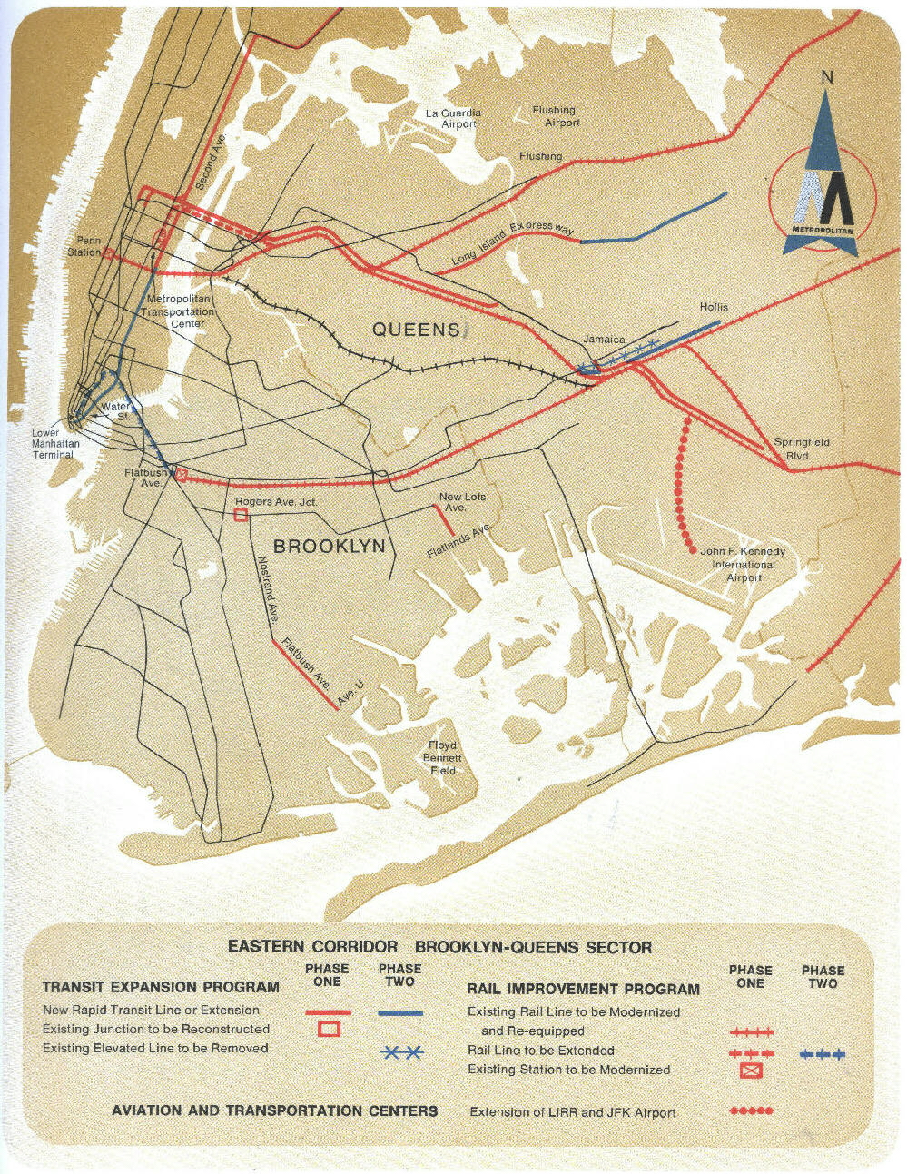
The 63rd St tunnel (today’s F Line to Queens) and Archer Ave subway (E,J in Jamaica) were planned as part of a much larger project to build a super-express subway from Jamaica, Queens to midtown Manhattan. As Queens grew in population after World War II new subway service lagged far behind. To address this, a new subway line to run parallel to the Long Island Railroad Mainline through Queens was to be built with connections to Jamaica and Far Rockaway. Many different plans bounced back and forth for years (the 63rd St tunnel was planned as far north as 76th St and as far south as 59th St). In 1963 a patchwork of various plans were brought together to connect midtown Manhattan to Queens with a super-express subway and to connect the Long Island Railroad into Grand Central Terminal with a new 4 track tunnel under the East River.
The first part was a new tunnel into Manhattan that would connect with the BMT Brodaway Line, IND 6th Ave Line, and a commuter rail connection to Grand Central. Starting construction in 1969 this project is actually still under construction! The line terminated at Queensbridge until December 2001 when it was finally extended to connect with the Queens Blvd line. The tunnels and new stations (Lexington-63rd St, Roosevelt Island, Queensbridge-21st St) were opened in 1989, 20 years after construction started due to many delays and funding problems. Today the only train running along the line is the F Line to Queens. A connection to the BMT Broadway Line was constructed from 57th St-7th Ave to 63rd St-Lexington Ave and is only used for storing Q Line trains which terminate at 57th St.
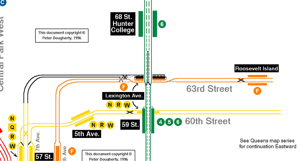
The station at 63rd St-Lexington Ave has a false wall, behind which is an unfinished platform and tracks that are only open to MTA employees. This non-revenue service track is planned to be connected to the first phase of the Second Ave subway, at which point the unused platform will be opened to the public. If you go to 63rd St station, on the platform, look through the holes in the black doors along the wall and you will see the unused platform, maybe even a train too.
At the same time a second set of tracks were constructed below the subway tracks with the intent to connect the Long Island Railroad with Grand Central Terminal. Though the tracks through the tunnel were built, no connections with either railroad were ever completed. It was only in 2006 when the first new tunnel contract was awarded. Construction has continued and can be viewed by passengers along the N/W line after Queensboro Plaza and a new terminal is being carved out below Grand Central Terminal. Service plans have not been finalized but this project goes a long way towards completing the next phase of the original project, a super-express line through Queens.
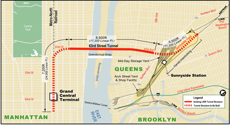
While a super-express subway was planned to connect with other lines, not as a commuter rail, soon riders from Queens will have a quicker route into midtown Manhattan. The original super-express line was to connect to the 63rd St tunnel in Long Island City and a new subway in Jamaica along Archer Ave. With this subway in place the MTA could have converted some of the Long Island Railroad right-of-ways from commuter rail (or abandonment) into subway service. Routes planned included out to the Rockaways through central Queens and through Locust Manor, along the Main line to Queens Village, and possibly out to St. Albans along the Hempstead line.
None of these plans (save for the Archer Ave subway) ever got out of the planning stages and central and southern Queens still remain lacking in broader subway service. As built the Archer Ave subway connects subways headed to Brooklyn and downtown Manhattan to subways headed to Queens and midtown Manhattan into one terminal. A bi-level tunnel was built, which interestingly does not allow for direct train connections between the two subways, along with 3 new stations.
The connection to the Queens Blvd line used an unused stub of track that had been planned for a never built subway under Van Wyck Blvd. The connection the BMT Jamaica line allowed for the elevated tracks running though downtown Jamaica to be torn down. The new tunnels and stations allow for further extension into Jamaica but no serious plans have come forth to do so.
The 7 Line extension from Times Sq-42nd St to 34th St and 11th Ave is living proof that subway expansion is possible when there is enough political will. The project as originally planned would extend the line under 41st St with a station at 10th Ave, turning south at 11th Ave with a station at 34th St, and layup tracks as far south as 25th St. The extension was proposed as part of the Hudson Yards redevelopment site, the Long Island Railroad train yards past Penn Station. Original proposals for redevelopment included a new Jets football stadium and a new stadium for the New York City 2012 Olympic Games (which went to London instead). After this, the MTA accepted bids for commercial redevelopment over the yards similar to the Atlantic Yards project in Brooklyn. Eventually a bid was accepted from the Related Companies, however due to the economic recession no work has been done.
Construction on the subway extension has been continuing during this time. Due to lack of funding the station at 10th Ave-41st St was dropped from the final plans, although support for finding funding for the station has begun to build. The extension is rather short but brings up an interesting anecdote about the subway system. In order to build the extension the MTA had to demolish an abandoned subway platform underneath Times Sq. When the IND was building their subway under 8th Ave they built the Times Sq station with three platforms, the two that are in use today, and a third below these. The peculiar thing about it was that there didn’t ever seem to be a reason for the extra platform. The IND built many parts of its system that it intended to build out later (see the previous post on the Second System) but this platform wasn’t one of them. Due to the track configuration the only trains that could enter this extra station were trains coming from Queens which could just as easily stop at the upper platforms (like they do today). The platform was used briefly to shuttle passengers out to the Aqueduct racetrack in Queens but hasn’t seen service since the 1980s. There is an urban legend about this platform, however, from NYCSubway.org:
An oft-repeated story offers this as a reason the lower level was built: The Independent subway was being built by the city to compete directly with routes owned by the IRT and BMT companies. The #7 crosstown IRT line terminates at Times Square; it is said that the bumper blocks of the #7 are directly against or very close to the eastern wall of the lower level of the 42nd St. IND station. The construction of the lower level therefore blocked any potential extension of the #7 line to the west side of Manhattan. If this is true, it would have been done only in the spirit of crushing the competition, for the IND had no plans to construct a competing crosstown line.
This is likely not the case, though the IND did build lines in direct competition to the other systems. Today the superfluous third platform has been demolished and the 7 train will one day soon be extended to the Far West Side of Manhattan, hopefully to help spur development since there isn’t anything there now.
More Information
If you are looking for more information on these projects here are some links that will help you.
- MTA Director calls for ambitious expansion; NYTimes 03/03/08
- IND 63rd St Line, Wikipedia
- Archer Ave Subway, Wikipedia
- 7 Subway Extension, Wikipedia
- 7 Line Extension Project Website, MTA
- East Side Access Project Website, MTA
- East Side Access, Wikipedia
- 1968 MTA Program For Action
- Trans-Hudson Express Tunnel
The futureNYCSubway
- IND Second System
- Post War Expansion
- The Second Ave Subway: History
- The Second Ave Subway: To The Bronx and the Nassau Line
- Brooklyn: Bushwick Trunk Line
- Manhattan: West Side and Hudson Crossings
- Queens: Flushing Trunk Line
- Staten Island: The Last Frontier
- TriboroRX and Atlantic Ave Super-Express
- Conclusion: the vanshnookenraggen plan
Fantastic stuff. I have always thought that there was enough space under Queensboro Plaza (plenty of empty lots) to build a G terminus that would allow direct connections with the M and $E. 21/Ely/Court Square is terribly designed. The E/M platform, is way too narrow and there are only access points at the ends of the platform. Should a disaster ever hasppen, heazven forbid, there will be more injuries than if it had happened at Queens Plaza.
Also, the MTA should think about branching the L to where the S4 junction would have been and running it to Second Avenue. It could branch off at Metropolitan Avenue/Lorimer Street where there would be minimal problems to normal life. At S4 a new J/M station could be built, connecting the G and the branched off L, making the housing in that area that much more valuable. From S4, you could travel to midtown (M), downtown (J) or the East Village (L branched off). You could take the G for uptown connections or downtown connections.
It would cool if the mta plan a 145th Street Shuttle , From Riverbank Park To 149th Street-Grand Concourse Station
Good research & I’m kinda excited their building another east side line to decrease the overcrowding IRT Lexington Ave Line