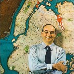
I present my Google Maps version of the proposed Lower Manhattan Expressway and Mid Manhattan Expressways. Now there have been maps showing these proposed highways before (they are included in my Unbuilt Highways Map of NYC) but the point of doing it up to look like a Google Map was to put these highways in a modern context (also I’m sure there are plenty of people who didn’t even know about these). We have become so accustomed to viewing the world through Google Maps (or some other online mapping software) that I feel like these maps are starting to shape our view point of the city.
I think that the purpose of the MBTA needs to be split from an all-encompassing transit authority into purely that of operations. A parent authority should be established that would take the debt burden off the MBTA and allow it to focus all funds on operations and maintenance.
Capital construction and expansion would be handled by [...]
Here is how I see American cities at the middle of the 21st century:
Because of high energy costs, living on large lots in the exurbs will no longer be affordable to the middle class. New policies will go into affect that support infill development in older city centers. As the populations of central [...]
While cleaning out my Google Maps directory I realized that I had a number of good maps that I had made at one point but never did anything with.
I’ve added a few maps of Unbuilt Highways;San Francisco, Washington DC, and Los Angeles, and Subways System Maps for Atlanta, Boston, Los Angeles, Philadelphia, and the San [...]