
Large format prints are available at my vanmaps.com store.
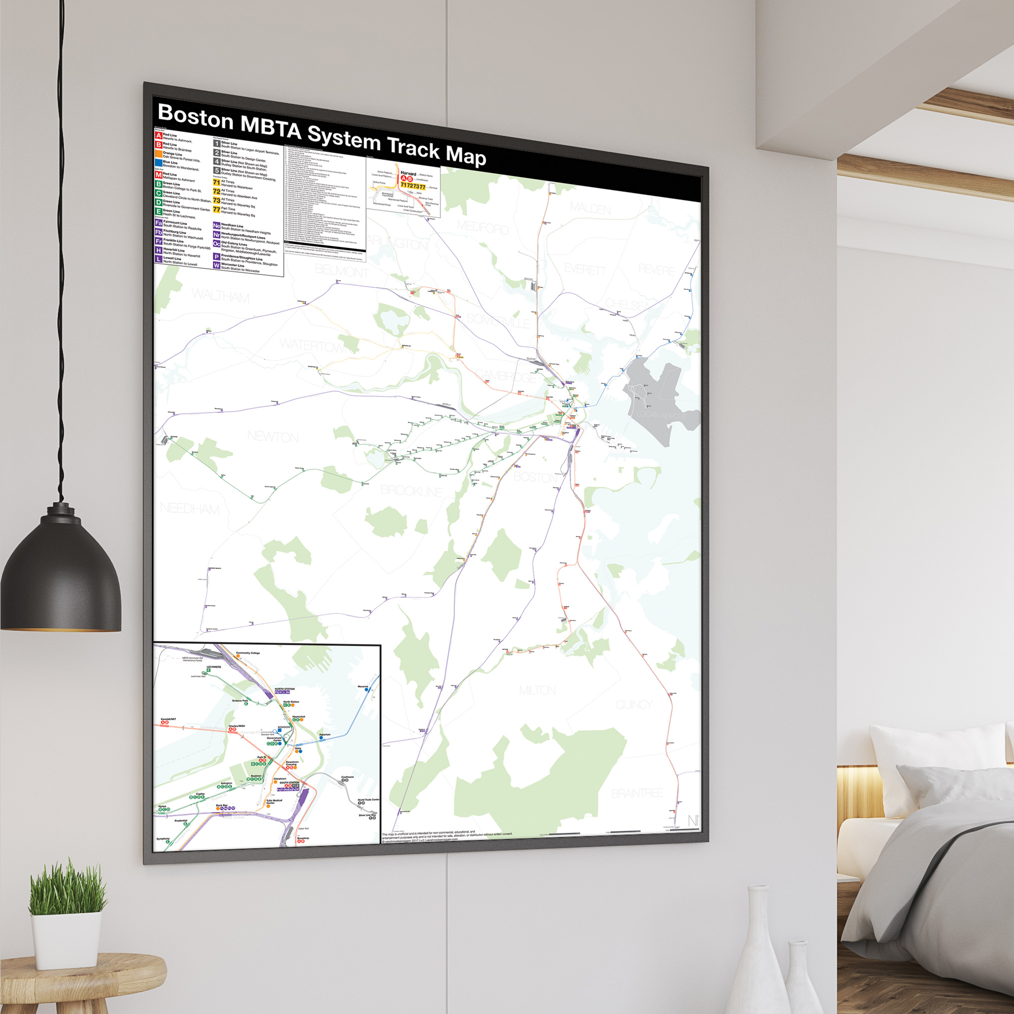
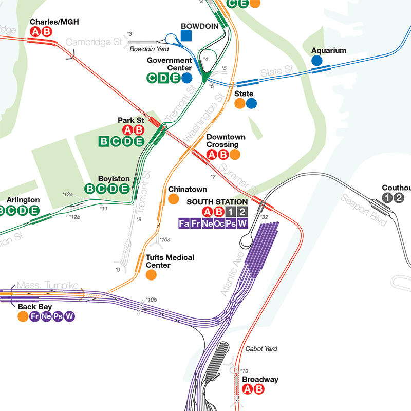
I was more than a little surprised by the response from the NYC Subway Track Map. The feedback was overwhelming and I want to thank all the railfans and transit nerds out there who contacted me with corrections. So with that in mind I am happy to announce the next map in what will certainly be a popular series, the Complete and Geographically Accurate Boston MBTA Subway Track Map. Like the NYC Map the Boston Map shows the tracks (and in some cases non-tracked tunnels) of every line in the MBTA system.
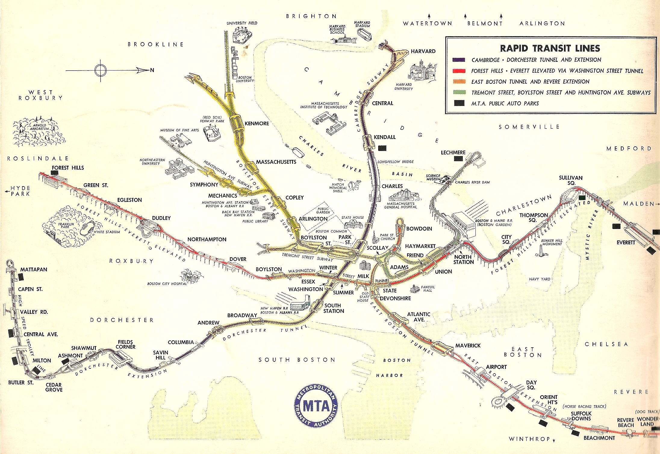
Unlike New York the Boston subway system (oldest in the US!) has a long history of detailed track maps throughout the ages. As a far less complex system I feel like the Boston Elevated Railroad (the company which ran the subway from 1989 until 1947) used the track map as a marketing tool so riders would have a clearer sense of where they were going. When the MBTA was created in 1964 it chose to modernize wayfinding (much as the MTA did in New York in the 1970s) by creating a color coded line system which gave rise to the Red, Blue, Orange, and Green Lines we know today. As part of that modernization system maps became more striped down and cartoonish as we know them today.
The purpose of my map is to do away with simplification and see the system for what it is with all tracks, revenue and non-revenue alike, along with train yards and, of course, abandoned sections. It was my time growing up in Boston hearing about the abandoned tunnels and unbuilt lines which gave rise to my love of urban planning, transit, and ultimately the creation of this website. So you could say this map is a bit of a home coming; going full circle.
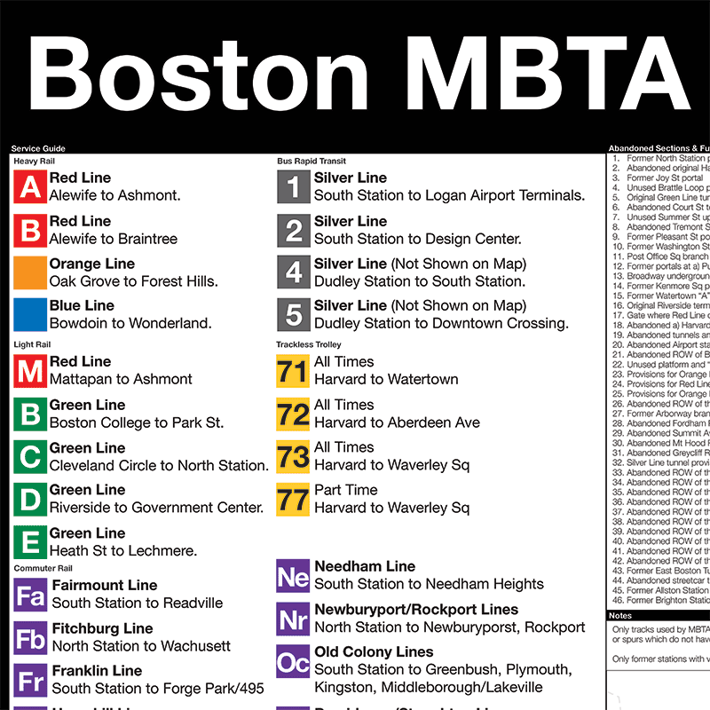
Transit in Boston is more nuanced than in other cities as it has a large variety of options: heavy rail, light rail (including streetcars), trackless trolleys, BRT, and commuter rail (there are also ferries but these aren’t included in the map). The Green Line was part of the first subway in the United States and over the years has seen the most change. Once a vast multitude of streetcars ran through the Tremont St subway but as buses replaced them the lines were cut back to the four we know today. Some streetcars were converted to electric buses, known as trackless trolleys, and a small network still remains in Cambridge. Once the Orange Line was elevated from Forest Hills to Everett with a branch running along Atlantic Ave but over the last century the elevated sections were replaced by modern subways. As the T expanded in the latter half of the 20th century many of the old steam railroads became cheaper alternatives than digging new tunnels and many of the subway extensions built after World War 2 utilized these paths. Commuter rail, too, has had a remarkable comeback after private railroads started to collapse with the rise of the car. Boston can boast greater transit coverage for a city of its size than almost any other American city.
[UPDATE]
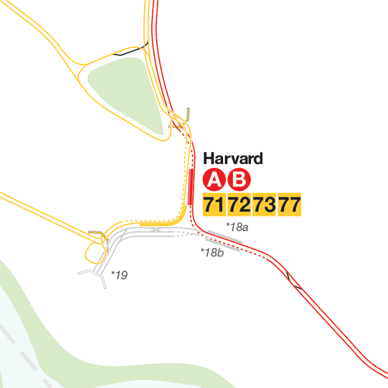
The reaction to the first version of this map was mixed, to say the least, and many people asked about the commuter rail. I went back and decided that just showing the subways didn’t paint a true enough picture of transit in Boston so I have released version 2 which adds both Commuter Rail and the Trackless Trolleys that run from Harvard Sq. I also added many of the abandoned steam railroad rights of way.
Large format prints are available at my vanmaps.com store.
“Needham” is spent.. “Nedham” on your man
In the Harvard Square inset you’re showing an “Active Portal” to the southeast of the station… there is definitely not a portal there, active or otherwise.
For the bus tunnel there is.
Also you show the route that Silver Line SL1 buses take on their way to the airport, but you do not show the route that they take to get back from the airport into the tunnel, which is quite different.
Now add commuter rail. I’ll wait.
I knew people would want the CR. Still on the fence about it but probably later.
Fascinating! Would you be able to do a historical track map?
I don’t plan on it. There are a lot online and through the Boston Street Railroad Association that you can check out. But what I might do is one for the system pre 1969 with the old els.
Amazing work, Van!
Only edits I’d suggest are:
— Placemarking the point on the Silver Line Transitway tunnel wall where the “Phase III†extension to downtown would fork off. There’s a subtle wall notch (but no outright turnout like the unused Green Line portals @ Arlington) right before the South Station turning loop, on the corner of Essex & Atlantic right underneath the front steps of One Financial Center. Any/all trajectories into the Transitway from Downtown (official, fantasy, or otherwise) would insert themselves into the existing tunnel here, since the Big Dig cleaned up the utilities underneath this block of Essex east of I-93.
— Marking the Orange Line’s connection to the national RR network @ the north tip of Wellington Yard. One yard track (with a small length of third rail) continues north of the Route 16 overpass along the tunnel wall and hooks into the Pan Am Medford Branch freight track at a hand-throw switch. Accessible from the Haverhill Line by turning out onto the Medford Branch, then backing up at the switch. Check Google’s most recent imagery (i.e. 3D off) and you’ll see that this connection has recently been brush-cleared for the first time in ages (prep for delivering track materials for the Wellington Yard expansion project???).
— Doing same with the Green Line’s outside connection to the RR network @ Riverside at end of the rear test track. That switch on the Worcester Line is still actively maintained, and has an active proposal for use with bringing Indigo Line regional trains from Allston-Newton into Riverside at a cross-platform superstation.
— Add to “12b†descriptor on Green Line that this is also the location of the wall notch for the never-built Post Office Sq. extension (inbound track side).
Thanks for the great feedback! I only just found out about the Silver Line provision so that will be in the next release. As of the connections between the RR network and the Orange/Green Lines I’m working on adding the CR to the map, though, it will just be for this map. I don’t plan on creating a whole network map for the CR. Finally, I do have the provision for the POS branch, it’s number 11.
I love this map! Thank you for making this. I have a few details to add:
Note 10: The current and abandoned Orange Line tunnels don’t split at quite the angle depicted; the abandoned tunnel continues in a straight line from Chinatown, as seen in this photo https://flic.kr/p/WjP99L.
Note 26: the former junction with the Needham Line was known as Cook Junction.
Chinatown station: the south end of the northbound platform is directly across from the north end of the southbound platform.
Haymarket station (Green Line): The tracks curve outwards to go around the abandoned platforms. The original station had two island platforms with 4 tracks total as shown here http://nycsubway.org.s3.amazonaws.com/images/articles/boston-1898-32.jpg.
State (Orange Line): the two platforms are farther apart from each other than depicted.
Downtown Crossing: The Red Line platforms do not extend beneath the Orange Line. There should be a gap there similar to the one between the Blue and Orange Line platforms at State.
Park Street (Green Line): the side platform on the eastern side of the station is the same length as the island platform across the track from it.
Thank you so much for this detailed response. I’m making a bunch of changes which will take a while before I make my next update.
Amazing work! One tiny quibble: the inbound platform at Greycliff Road was located east of the grade crossing (staggered from the outbound platform).
Thanks! They’ve since ripped up the old platform and I couldn’t find any correct info about it.
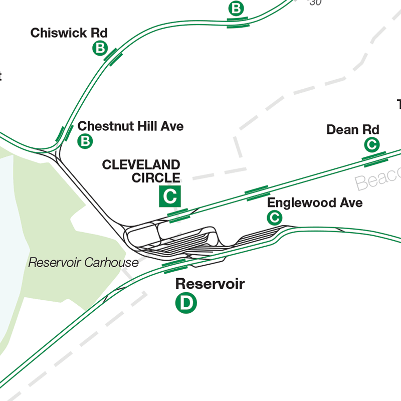
D cars at least used to sometimes run as short turns to Reservoir and stop on the track that connects the D and C lines. There was a platform there that usually just served as a walkway. If they still sometimes stop there now, you might want to make the little bit of that track nearest to the D line green (revenue track).