
On December 31, 2016 the first phase of the long awaited 2nd Ave Subway opened from 63rd St/Lexington Av to 96th St/2nd Av. Jaded New Yorkers, exhausted by nearly a decade of construction work, made their way down through the new stations to marvel at the accomplishment. The Great White Whale of New York transit lore had finally been bested and we were lost in the moment, celebrating the fact that the city had fulfilled a promise nearly 90 years old. But after the euphoria died down and commuters began to adjust to the new line the inevitable question of “what’s next” came up.
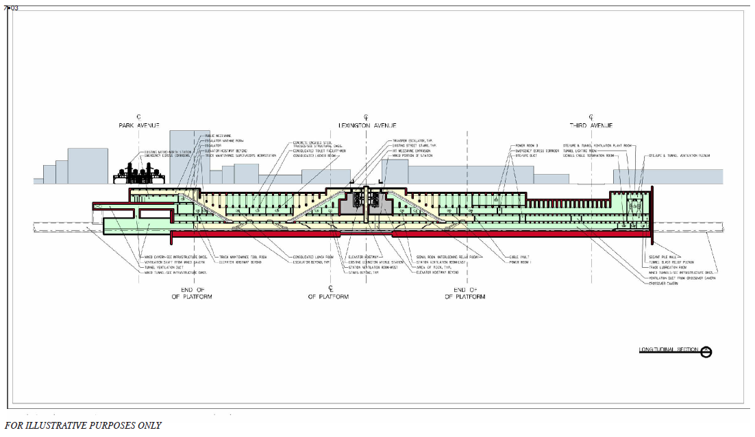
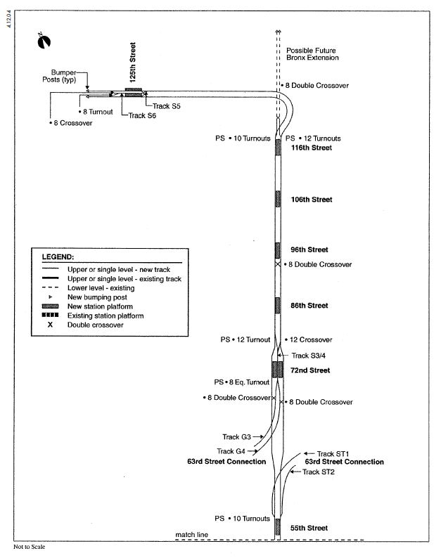
Planning for Phase 2, from 96th St/2nd Av to 125th St/Lexington Av has begun but construction isn’t planned to start until after 2019 because funding was cut by Governor Andrew Cuomo from the 2015-2019 budget. Currently engineering work is being done along with utility relocation for Phase 2. Phase 2 also will reuse the original tunnels built in the 1970s from 96th St north to 120th St. The 1970s plan, oddly, did not include a station at 116th St but instead had space for a third track for layups and maintenance; this space is now being planned for an infill station at 116th St. North of 120th St the line will make a broad curve west under 125th St (supposedly with provisions for an extension north to the Bronx) and will terminate at a station several stories below the existing 125th St Station on the Lexington Av Line and an exit connecting to the elevated Metro-North station at Park Ave. Even with the reuse of the existing tunnels the current price tag is around $6 billion which has given many pause since Phase 1, which did included new tunnels, clocked in at $4.5 billion. Should Phase 2 actually cost what it is projected it would be the most expensive subway line in the world out shining the current champion, Phase 1 of 2nd Av.
While cost is on everyone’s mind there is at least momentum to get Phase 2 built. The same cannot be said for Phases 3 and 4. What may come as a shock to riders is that the MTA does not actually see the last two phases as a priority. Their mentality is that the crowding on the Lexington Av Line is worst along the Upper East Side and that south of 63rd St there are more options for riders and less need for a new trunk line. The MTA cannot be totally faulted for this mentality, after all they are primarily in the business of running trains, not urban planning, and their primary concern is dealing with existing congestion so trains run smoother and safer. When the New York City Transit Authority ran the subways before 1968 it was part of the city and beholden to the Mayor which meant there was more pressure to expand to serve new areas. When the MTA was created in 1968 it was a state agency so their onus for city planning was reduced. Since then the MTA has been focused more on maintaining the crumbling system rather than expanding it.
Phase 1 of 2nd Av was designed so that it could directly connect to the existing system, rather than an entire separate line, and show the city that it could actually be built. This was a political decision and ultimately a wise one as it has had a direct positive impact on subway crowding already. But going forward it is becoming increasingly clear that the division between city and state needs is now starting to have long term consequences when it comes to 2nd Av and the future of transit in NYC.
The underlying fault of the current iteration of the 2nd Ave Subway is that it’s being designed as a single entity when every other line in the system, and the original concept for the 2nd Ave Subway, were all designed as parts of a larger network. The NYC Subway works differently than most other subway around the world with a trunk/branch system. The trunk/branch system is not unique to NYC but what is unique is that NYC has multiple trunks that interface with one another via reverse branching. When originally planned in the first half of the 20th Century the 2nd Ave Subway was part of the IND system, the A/B/C/D/E/F/G lines built by the city. When the city took over the other two private companies in 1940 (the IRT and BMT) and merged all three there was an opportunity to connect the trunk lines in new ways. In 1967 the Chrystie St Connection was the largest of these changes and originally was designed as the southern end of the 2nd Ave Subway. In theory a rider coming from Brooklyn could enter the subway and take one of three trains which would have run up Broadway, 6th Av, or 2nd Av.
As costs rose and construction of new subways sputtered out the scope of 2nd Av was reduced further and further. In the 1970s when shovels started turning earth the concept was whittled down to a two track line with fewer stations for faster service. There would be a transfer at Grand St so riders coming from Brooklyn could reach 2nd Av and a branch to Queens via the new 63rd St Tunnel planned as a super express line out to Forest Hills. In this concept at least the needs of riders coming from Brooklyn and Queens were addressed. In 1999 the Environmental Impact Statement for the current concept of 2nd Av was produced and updated in 2004. This lost the line to Queens since the super express line had been scrapped long ago (though the track connection would be built to the 63rd St Tunnel) and altered the Grand St transfer from a cross platform transfer to adding a new platform two levels below the existing station; the reasoning being that building a cross platform transfer would disrupt the neighborhood too greatly due to cut-and-cover construction. In its current form transfers from Brooklyn will require two sets of stairs and there will be no line to Queens, the borough in greatest need of congestion relief. Phase 4 plans on extending the line south to Hanover Sq with tracks turned towards Brooklyn should a new tunnel be proposed. But due to the location of Phase 4 the new line won’t allow for transfers to any downtown stations with access to Brooklyn. What this means in reality is that we plan on building the most expensive subway in the world that will help far fewer New Yorkers than it possibly could all because a state agency prioritizes a narrow definition of service over the needs of the total system.
It is probably, then, a blessing in disguise that Phase 1 and 2 have cost so much and taken so long. The current plan for 2nd Av was finalized in 2004 (with adjustments as construction costs rose) with Phase 1 opening 12 years later. With everything learned from Phase 1 I’m optimistic that Phase 2 could be done in half the time. But that would mean the first half of the subway took close to 20 years to build. Today subway delays and crowding is at an all-time high and ridership is the highest it has even been. The projections from the EIS, currently 13 years old, need to be discarded. Phase 1 and 2 lack express tracks due to the limitations of the tunnels built in the 1970s. This kind of poor forethought needs to be avoided for Phase 3/4 which by the time they might reasonably be started will need to be totally rethought.
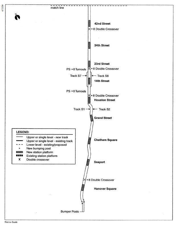
The current plans for Phase 3 are as such: at 55th St an island platform station, north of which two sets of tracks split with one continuing to 72nd St and the other curving east to connect to the 63rd St Tunnel; south of 55th St the line is two tracks with island platform stations at 42nd St, 34th St, 23rd St, 14th St, and E Houston St; between 9th St and 20th St is planned for an additional two non-revenue tracks outside the revenue tracks for storage. Phase 4 continues the two track line south of Houston St, curving around and below the existing Chrystie St tunnels with a new platform two levels below the existing Grand St station; curving west to Chatham Sq (an existing tunnel built in the 1970s will not be used for tracks because of the new depth planned but instead be used to ancillary utilities), and then continuing south to Hanover Sq with an intermediate station at Fulton St/Seaport. Plans for a bi-level terminal at Hanover Sq were scaled back to a single island platform and tail tracks pointing towards Brooklyn.
It is obvious that this is the leanest plan possible and allows for limited connectivity with the existing network. The bare bones plan wastes the potential that a new trunk line provides. But this plan deals with the reality that building through midtown Manhattan will be far more complex than along the UES where much less existing underground infrastructure exists. The costs for Phase 3/4 will be huge due to the complexity of the project but it is far worse to design something ineffective because it will be cheaper than to make a greater investment that will return more dividends to the city in the long run.
Subway planners need not look far for a better alternative. In 1940 the IND 6th Av Line opened to the public as one of the most complex subway projects ever undertaken in NYC and the last new major trunk line. Built to replace the 6th Ave El, which kept running above as construction took place, the subway had to be built around three existing lines including the Hudson & Manhattan Tubes (today the PATH) which were already running below 6th Av. Construction took 5 years and cost $59,500,000 in 1940, $1,034,783,763 in today’s dollars (based on conversion from https://westegg.com/inflation/). Because of the existing H&M tubes the express tracks were only built from 53rd St south to 34th St and at W 4th St Station. The 6th Av Line was designed to be integrated into the IND system with connections to the existing 8th Av, Queens Blvd, Crosstown, and Fulton St Lines. Provisions were built into the line for future integration with the 2nd Av Line as well (which was built as part of the 63rd St Tunnel and is in use today by the F and Q trains). In the 1960s as part of the Chrystie St Connection the express tracks were built between 34th St and W 4th St so that express trains could connect to the Manhattan Bridge. It was the foresight of subway planners that future connections would be needed when ridership increased and money became available. It is with this as a guide that present subway planners need to rework the future of the 2nd Av Subway so it can make a larger impact on the subway network as a whole.
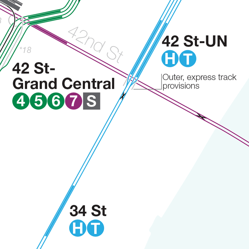
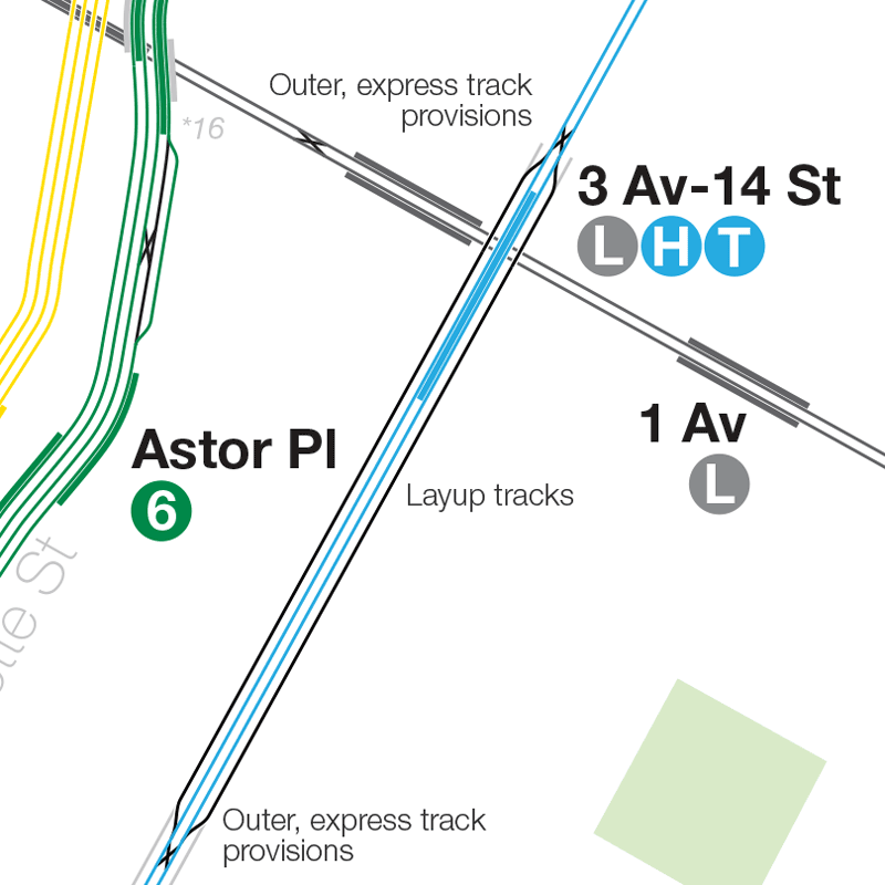
What is needed is to design Phase 3 to be as lean as possible but also allow for future expansion for the addition of express tracks and provisions for a new tunnel to Queens should the need arise. The most important section of 2nd Av that needs to be redesigned is in Midtown East, stations at 55th and 42nd Streets. 55th St is a bit of a misnomer since it will most likely have an entrance at 57th St but the reason for locating the station further south than, say, 59th St is due to the need for the junction with the 63rd St Tunnel. The new 55th St Station will feature two island platforms and four tracks, something planned in the 1970s proposal but dropped in the 2004 EIS. North of the station, between 57th and 61st streets will be a six track cavern: the outer most tracks will continue north and connect to the existing 2nd Av Subway with bellmouth provisions for future express tracks to the Bronx, the middle tracks will drop down to connect with the 63rd St Tunnel and the innermost tracks will be used for layups and storage and can also be connected to the existing 2nd Av tunnels to the north. The reason for the layup tracks is so that any future service coming in from Brooklyn can terminate in midtown if there is no extra capacity north or to Queens. South of the station will be three double crossover switches to enable trains from Queens to terminate at 55th St if need be.
42nd St Station will also feature two island platforms and four tracks but just south of the station the outer tracks merge with the inner tracks with provisions for future express tracks. Heading south 34th and 23rd St Stations will remain as island platforms, two track stations; when express tracks are built these will be bypassed. 14th St Station will remain the same as well but the additional layup tracks planned between 9th street and 20th street will be shifted south. The Houston St Station will be built with two island platforms but only two inner tracks; the outer trackways will be sealed off and the layup tracks planned at 14th street will be moved south between 3rd street and 14th streets.
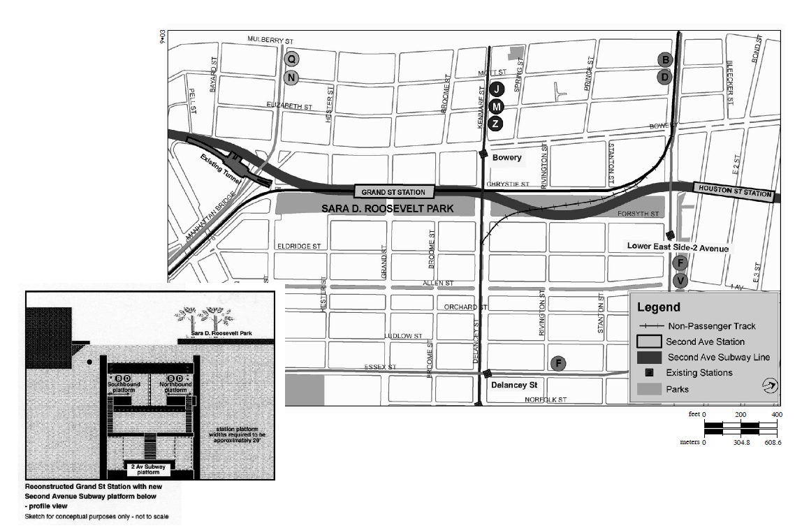
Originally there was the option to connect 2nd Av to the Centre St Subway at Bowery Station but the proximity of the station to where the 2nd Av tunnels would be built would mean that the station couldn’t be used (and most likely would have to be demolished) and that the existing curves in the tunnel would be so tight that it would force 2nd Av trains to slow down considerably. The simplest solution would then be to rework the existing tunnels built for the Chrystie St Connection. The current express tracks (used by the B/D trains to reach the Manhattan Bridge) would be severed from 6th Av and connected directly to 2nd Av. This would only require digging under the northern section of Sara Roosevelt Park. 2nd Av trains would take over from the B/D with the planned T train taking over the D via 4th Av-West End to Coney Island and a second 2nd Av train, what I’ve labeled the H train in my map, using the 63rd St Tunnel to Queens, taking over the B to Brighton Beach. The express provisions would allow for a future expansion south of Grand St Station which would be more cost effective if it was to swing west under Park Row and then connect to the Nassau St Subway just south of Chambers St Station to allow for trains to use Nassau St and the Montague Tunnel to reach Brooklyn. Because of the way the provisions are designed the 2nd Av Subway would be flipped from the normal layout of trunk lines with express tracks on the outside and local tracks on the inside.
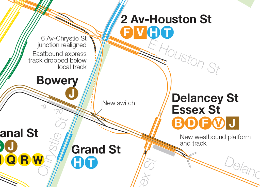
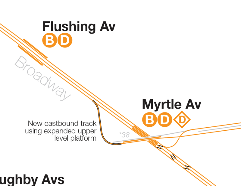
This frees up capacity on 6th Av to be used to serve Williamsburg; the express tracks at 2nd Av Station were built for a future tunnel to Williamsburg but the service could be reimagined for cheaper. As ridership in north Brooklyn continues to rise and alternatives to the L train are few, rerouting the BMT Jamaica Line up 6th Av would be a boon for the area. The local tracks (used by the M train to connect with the Williamsburg Bridge) would be readjusted to connect to the express tracks of 6th Av east of Broadway-Lafayette St Station. Essex St Station would be altered so that the westbound platform and track is swapped allowing access to the center track (see diagram); this would allow for a new shuttle service to run off hours between Broad St and Essex St. B/D trains could now operate over the Williamsburg Bridge replacing the J/M/Z service; D trains to Broadway Junction and B trains to Metropolitan Av. This would be a separate project in and of itself in that it would require expanding the Broadway El stations for longer cars as well as rebuilding the Myrtle-Broadway interlocking to allow for more service; all of this would be a far cheaper alternative for expanding service to Bushwick and Bedford-Stuyvesant than building a new subway. Also freed up is the capacity along the 6th Av local, now used by the M train, which can now be used for express service along the Culver Line (labeled the V train in my map).
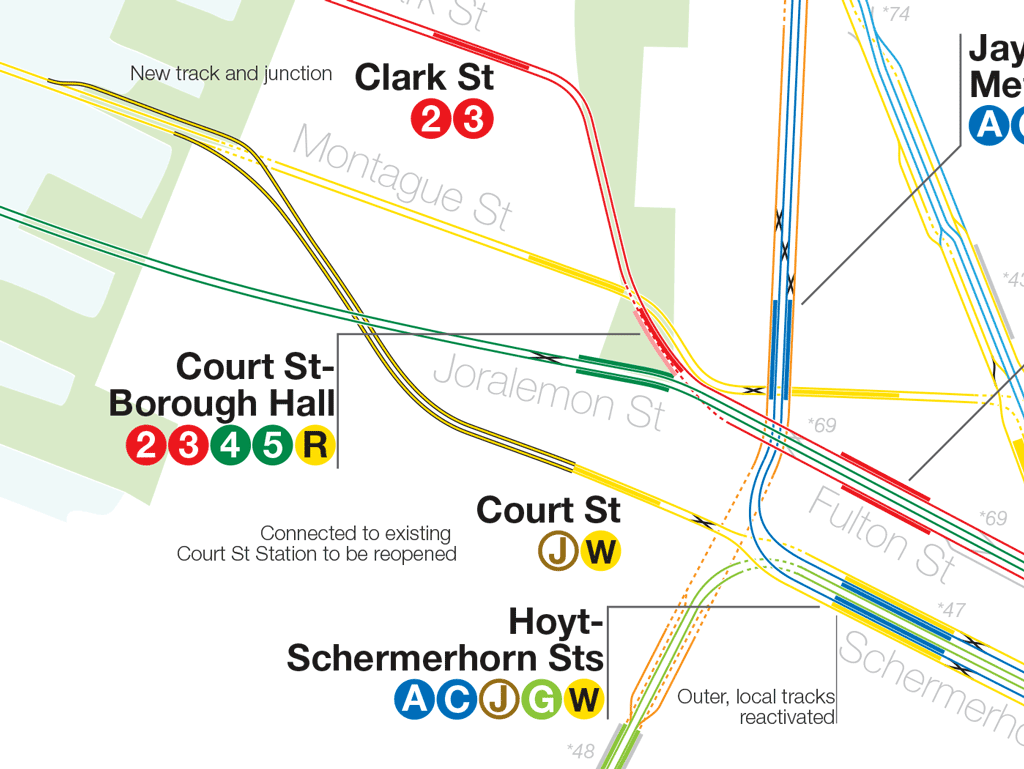
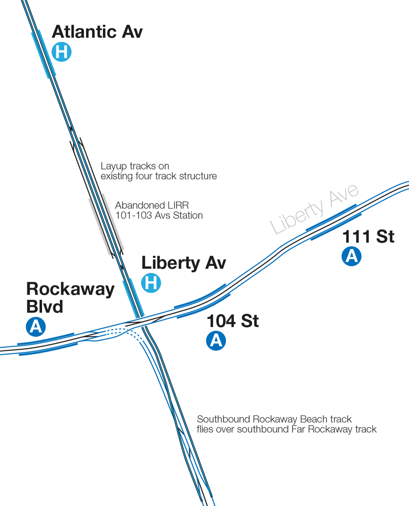
Service past Broadway Junction would need to be altered as well due to the curves at Crescent St and would involve a third project to add capacity along the IND Fulton St Subway. The Fulton Line runs at 50% capacity, max, because the four tracks are truncated into two to allow trains to navigate the Cranberry St Tubes. The two local tracks continue on to the decommissioned Court St Station (home of the NY Transit Museum) and plans from the 1930s called for using these tracks to connect to the 2nd Av Subway. Given current ridership levels the existing Montague Tunnel (used by the R in the day and N at night) runs well under capacity. If a connection between the two was built, in the same fashion as the 11th St Connection in Long Island City between the BMT 60th St Tunnel and the IND Queens Blvd Line, then the extra capacity on both lines could be taken advantage of. W trains, which now terminate at Whitehall St due to the lack of demand from south Brooklyn, could then be extended east through Fulton St. C trains could then run a flexible service running express at rush hour and local at other times (or opposite depending on demand as ridership has grown over the last 5 years along Fulton St).
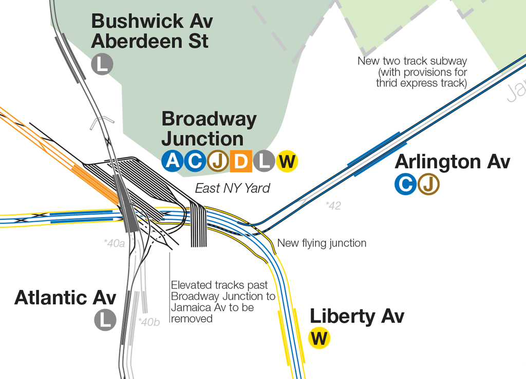
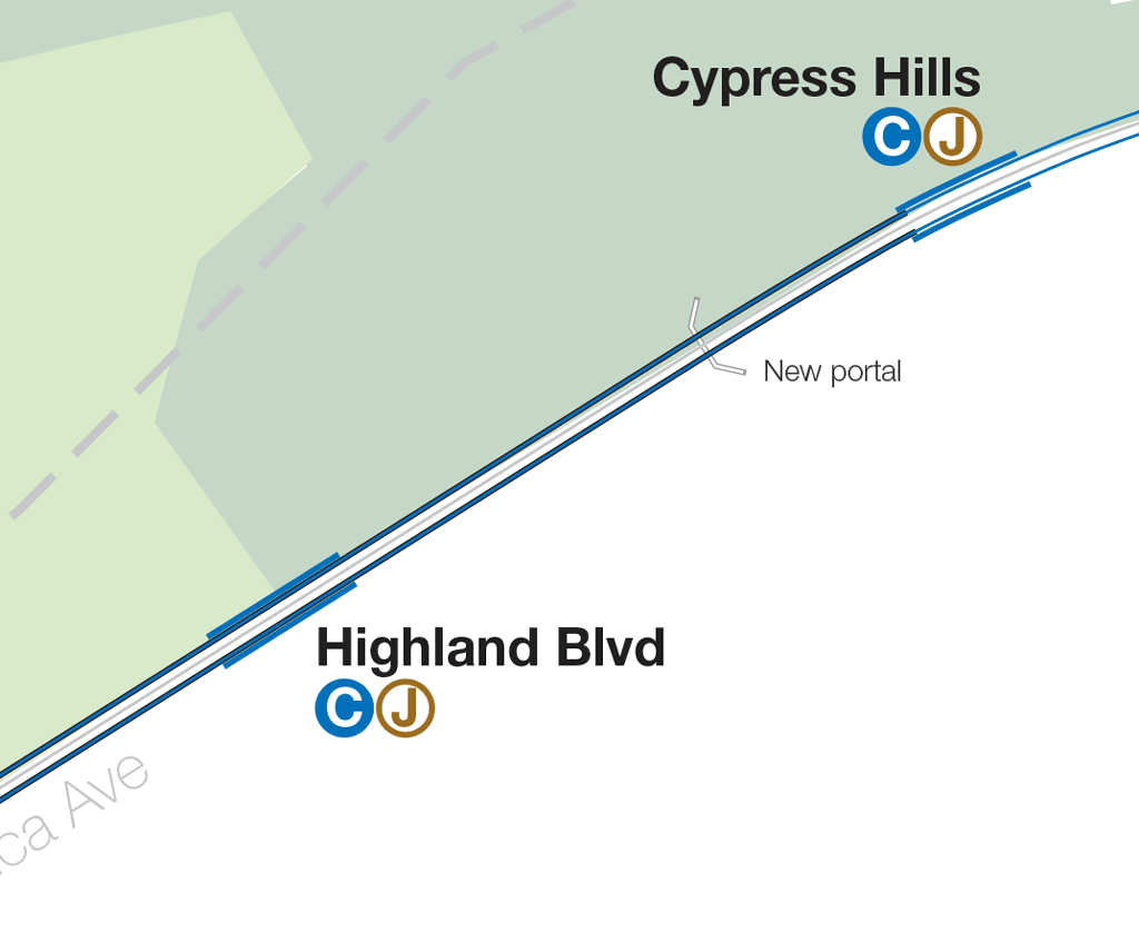
At Broadway Junction this new local service would allow for a branch off to replace the BMT Jamaica Line elevated structure along Fulton St and Crescent St. This new subway, along Jamaica Av to Crescent St where it would rise to meet the existing elevated track, would eliminate the slow curves at Crescent St and allow for faster service downtown for Jamaica riders. C trains would replace J/Z trains, through with the extra capacity some J trains could also run from Jamaica to Chamber St via Fulton St using the Nassau St connection within the Montague Tunnel. Service on the Broadway elevated, now used by B/D trains would terminate at Broadway Junction (or possibly Atlantic Av for an easier cross island transfer). This project would better serve the needs of north Brooklyn riders looking to reach Midtown as well as Jamaica riders who now no longer have to transfer at Broadway Junction for a faster ride downtown. L train riders coming from Canarsie have a better option in using 6th Av trains with the elimination of the very long transfer at Broadway Junction and can avoid the crowds at Bedford Av.
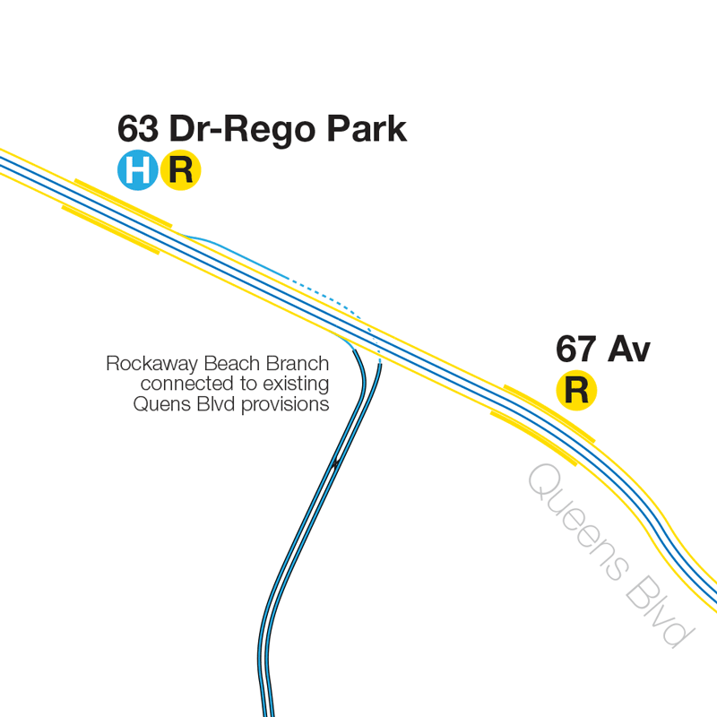
Finally, in Queens, the addition of a 2nd Av train on Queens Blvd and the reduced need for the M line means that service can be better adjusted along the Queens Blvd Subway as well as the addition of the Rockaway Beach Branch. Depending on the needs of riders there are a variety of service options so as an example: 2nd Av trains are routed along 63rd St and local out to Rego Park where they branch off and head down to Rockaway, M trains are converted back to V express trains via 53rd St and out to Jamaica-179th St (taking over the few express E trains that use the terminal at rush hour). This way Queens Blvd riders have options for both east and west sides of Manhattan as well as additional express trains.
Future extensions in upper Manhattan and the Bronx must also be considered such as extending 2nd Av west to Broadway and building a new branch north. The original concept for 2nd Av was to allow better service along the 6 train by rerouting it down the express tracks of 2nd Av. With no express tracks this leaves the northern end of 2nd Av acting as a branch line rather than a trunk line. Without them it hardly makes sense to extend the line further north since it would require riders transfer from express trains to local trains when they could just stay on the express via Lexington Av. Adding provisions for future express tracks in Midtown would open up more options in the future such as finally replacing the 3rd Av El torn down in the 1970s or converting the 6 train to B Division and giving Pelham Bay riders a faster ride downtown.
Admittedly this plan will cost much more than the existing 2nd Ave Subway proposal and involve considerably more parts. But the point I’m trying to illustrate is that the current plan only helps residents along the east side of Manhattan get uptown or downtown a little better. It does almost nothing for riders from Queens and Brooklyn, to say nothing of the Bronx. Building strategic connections and reworking bottlenecks to open up capacity uses the new trunk line to its fullest potential. The plan I’ve created doesn’t even require full express tracks be built but does allow for them in the future should demand along 2nd Av for downtown service grow. Express tracks could then be built later (in the same way that it took 27 years to build express tracks on 6th Av) and new services added for demand we cannot today predict. Knowing how similar multi part projects have gone in the past (IND Second System, 1968 Program for Action) it’s wise to assume that some sections may not be built. But the point is to design the project so that one day they could be. Planners today are scared that they can’t get anything built that they don’t even bother to design their projects to full potential. The current transfers to 2nd Av require riders using multiple stairs and long corridors all because planners are too scared to design their stations properly, even if it means more disruptive construction. If the 2nd Ave Subway is not designed correctly then it will be the most expensive mistake since ramming highways through dense cities. The NYC Subway is littered with poor planning mistakes which have hampered service ever since; we need not make the same mistakes. Costs must be brought under control cost should not be an excuse to build a less effective subway line. Transit should be built where it’s most effective not where it’s cheapest to build.
Edit 5/28/2017: After discussion here and on social media I’ve created a second version which swaps the V and H trains. H trains now run down 6th Ave and V trains down 2nd Ave. V trains would take over from the B as Brighton Beach express but would face a bottleneck on Queens Blvd. Because of this the layup tracks at 55 St-2 Av would be even more important for extra service on Brighton Beach.
Interestingly the low V frequency on QB makes space available in the 63rd St Tunnel for rerouted R trains. As there is now 2nd Av service through 63rd St this deals with the issue of the loss of transfer at Lexington Av: R trains riders can switch at Roosevelt Island or 21 Av for east side service on the V!
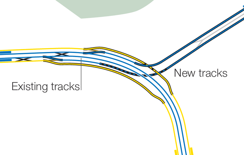
Lastly, I took a look at Queens Plaza and with the addition of two new switches I finally figured out how G trains can terminate there instead! Just north of Court Sq (G) a double crossover can be installed and on the Manhattan bound tracks approaching Queens Plaza station the single crossover can be upgraded to a double. This separates terminating G trains on the outside, “local”, tracks and E/H trains on the inside. Riders coming from Brooklyn and wanting to continue to Queens can just walk straight across the platform and vise versa for riders coming from Queens going to Brooklyn.
See the alternative map here.
Note: This post is not a fully realized futureNYCSubway proposal but rather a plea for planners to reconsider what is being planned for 2nd Ave. I hope to show that with strategic connections the 2nd Ave Subway can have a wider ranging impact on the system as a whole. Growth in norther Brooklyn and southern Queens can now be better addressed by freeing up existing capacity. Unlike with the much broader futureNYCSubway maps this is a much more focused and realistic vision should the powers that be chose to change their plans.
Why did you end the Q, & T trains at Saint Nicklas Avenue when you could continue it to Broadway 🎠With a Conection to the 1.
A few factors. The geography makes transfers between the two long and expensive to run. Also I feel that the ridership wouldn’t justify the extra cost. I could be wrong tho.
First of all, I love how you used your track map to make this plan. Now I will comment on the plan. The first thing that stands out for me, my favorite part, and something that I fully agree with, is having four tracks from 63rd to 42nd on Second Avenue. This would allow for additional trains from Queens if need be, would allow for a terminal in the case of a disruption, and it would allow for future express tracks.
As much as I like that part, I have some problems with this plan. You have the V coming back, but as an express via Queens Boulevard. I know that CBTC will allow for additional TPH, but the highest it can really be is 36 TPH (the MTA’s low estimate is 32 TPH). Here you would lower TPH on the E and F, for 12 TPH for each service. The E needs that service, and it would be a bad idea to cut it.
In terms of W service, what would be the TPH during rush hours. I think that it would have to be increased, and to do so, either some W trains would have to go via Second Avenue, or the terminal layout at Astoria has to be rebuilt. You can have some trains go via Second Avenue if a connection between the Broadway local tracks and the 63rd Street Line is built using the trackways that were intended for a line to the Upper West Side.
While cost-effective, I am not sure that it is the best idea to have the W run via Fulton Street. The A and C already go to Lower Manhattan, and the W would just be a lot slower. The A and C would be packed, while the W would be empty–remember, the W would have 10 car trains as opposed to the C’s 8 car trains. I would have Phase 4 of the Second Avenue Subway built with a new tunnel under the East River, connecting to the Fulton Street Line without using the Court Street station. It would run via State Street with a stop at Clinton Street. However, if necessary, the Montague Street Tunnel could be used, but Nassau Street should NOT be used. All the problems for this can be found in the 2004 FEIS. A difficult connection would require taking property, the route would be slow, future services would be hindered due to the lack of capacity, and the platforms would all have to be extended. By having a Second Avenue route go via Fulton and Lower Manhattan, crowding on the 4 and 5, and perhaps the 2 and 3 for that matter, would decrease. People who live in between the Eastern Parkway and Fulton Street Lines who want to get to the East Side would use the crowded 4 and 5. If the T ran via Fulton Street and Second Avenue, they would switch over, and in addition, having the SAS not go to Lower Manhattan would not allow for the full usage of the line.
Another issue I have concerns the BMT Jamaica Line. I do not know why you have an obsession of having the B and D go via that line. I just don’t understand why this is necessary. There should be an express on that line. I would convert Woodhaven Boulevard to an express station. The third track would rise up above the station, and there would be an express platform there, similar to how it worked on the Second and Third Avenue Elevateds. The third track would be installed, and between Cypress Hills and Broadway Junction, the express track would bypass these stops by going over Jamaica Avenue. The junction at Myrtle Avenue would be rebuilt. I love your creative way of doing this. There would be a Union Avenue station, and Marcy Avenue would be rebuilt with two island platforms. J express trains would be significantly quicker to Lower Manhattan (10 stops from Jamaica Center to Fulton vs. 20 (inc. transfer to A or C). This would increase its ridership and reduce crowding on the E. I don’t think that splitting the line into two is necessary. You would need a lot more yard space if you are doing that and in this plan you do not provide it. The B and D running via the connection to the Jamaica Line would completely bypass the SAS, making it hard to transfer between them. I don’t like how you are severing the connection between Sixth Avenue and the Manhattan Bridge.
I like that the Rockaway Beach Branch is including it, but you are totally defeating the purpose. The line runs through underserved communities, and these people want transit service. Just having a stop at Metropolitan Avenue doesn’t cut it. There is pretty good ridership on the Q52 and Q53, which will become SBS in the fall. I would include stops at Fleet Street, Metropolitan Avenue, Union Turnpike, Jamaica Avenue, Atlantic Avenue, and Liberty Avenue.
I know that this is a map for the SAS, but the Queens Bypass should be built with the Port Washington Branch converted to subway operations. The N would run via the Queens Bypass and the Port Washington Branch via a short elevated connection at Queensboro Plaza. The V would run via 63rd Street and the Bypass to 179th Street.
On the northern end, I would not have a 125th Street Crosstown. Have the line run via Third Avenue and Park Avenue in the Bronx before turning east via Pelham Parkway to Co-Op City. Initially it can terminate at Third Avenue–149th Street.
Thanks, and I am interested to hear what you have to say.
The Queens Blvd service well never be perfect. Think of the V as more like an extra rush service to use up any existing capacity. I labeled it differently to avoid confusion over 63rd vs 53rd tunnel running. Admittedly this would reduce capacity on 6th Ave locals. But it was one type of configuration and others can be looked at.
W trains would probably remain the same since you’d also have the addition of J trains and C trains would pick up the express slack. However if a future connection between 2nd Av-Grand St and Nassau St Subway is made then the W or another train could be routed along 2nd Av-Fulton St with higher capacity. The point here is the build the little connections first rather than a whole project. What you are suggesting is far more involved, complicated, and expensive than just connecting the tunnels we have and extending the platforms. The EIS looked at just one use of the Centre St Subway which I agree isn’t great because of the extreme curves. What I’m suggesting is to just use Nassau St for a straighter, faster run. That is the ideal. What I’m suggesting is foregoing Phase 4 entirely and spending that money on reworking Broadway Brooklyn and Fulton St to address growing ridership and changing needs.
Which brings me to why I’m so “obsessed†with the Jamaica Line. Basically it’s a dinosaur built for a different age. It’s design limits service and while I’d love to rip the whole thing down we can’t realistically do that. So my plan is to reimagine it to better serve modern riders. The trip from Jamaica to lower Manhattan is too long via the J, even during rush hour. Mobs of riders transfer at Broadway Junction. So building a branch of the Fulton Exp will give Jamaica riders a faster one seat ride. Then You have to look at the changing demographics in Bed Stuy and Bushwick which is demanding more midtown service since the M was rerouted. The Centre St Subway has some of the lowest ridership numbers and those who use it often transfer to uptown trains anyway. Routing the 6 Av express via Williamsburg removes a lot of the congestion with transfers. Additionally it would require platform expansion, something needed anyway to deal with ridership growth (admittedly the L needs it more).
One fault you bring up that I do agree with is the lack of transfer between the B/D and 2nd Av. Ideally there would be a new East River tunnel and a new portal for the B/D to connect to the elevated structure before Flushing Av. But that adds cost and would leave Williamsburg Bridge useless. Riders can still transfer at Bleecker St-Broadway-Lafayette St for the 6 which will see less traffic due to 2nd Av. 2nd Av need not take up all traffic from Lexington Av, just enough.
Further Jamaica express service should be looked at. I was thinking with a third track there could be super express C service which would be far faster via Fulton than Broadway Brooklyn. You bring up a good point about yard space. I suppose the E NY Yard would have to be expanded to handle the IND trains. This might be needed anyway if the new flying junction is built below it.
I chose to keep stations along RBB few due to what I imagine will be strong NIMBY opposition and also to speed up travel. Infill stations can always be added later.
The whole point of this post is to show how 2nd Av can be better integrated into the existing network. Bronx and Super-express lines are entirely other propositions. Needed as they are they were beyond the scope of this post.
Thanks for the great feedback!!
Some excellent stuff here:
While it would require extending many of the existing stations on the Broadway-Brooklyn line to be expanded to handle 600′ trains (something that needs to be done anyway for other reasons), having the (B) and (D) moved to that line via new connections at Christie Street with the (T) replacing that along the north Manhattan Bridge Tunnel with it going straight into Grand Street makes a lot of sense.
Also making a lot of sense (via new connections that would be straight) would have the Montague Street line connect to the currently unused local tracks of the Fulton Street Line. This would allow for greater flexibility since it would for example allow for the (W) and possibly (J) to run after lower Manhattan via the local on Fulton, with one or both lines running to Euclid (or further). This allows for the Fulton Street line to potentially have connections to the Broadway and Fulton Street lines.
The interesting one is new subway between Broadway Junction and Cypress Hills that would be used by the (C) at all times and the (J) in rush hours only (with the (C) express along Fulton) as the (W) would take over as the full-time Fulton Street local. Yes, that eliminates the one-seat ride on the existing Broadway-Brooklyn line (as the (D) is this proposal would at the existing Broadway Junction station on that line with the line past there to Cypress Hills demolished (and replaced by a new subway line between Broadway Junction and Cypress Hills via new connections from the Fulton Street Line), but it also does eliminate slow curves that likely makes a two-seat ride (especially since Broadway Junction would be the terminal for new Broadway-Brooklyn trains).
Also like the idea of the (B) running from Metropolitan Avenue (replacing the (M) that would be decommissioned) and becoming a 19/7 line running to 145 (Rush Hours to Bedford Park Boulevard). That might make more sense in this total reconstruction as well.
There are a few problems you should look at.
First, C trains should maintain its current route. Having the C go to Jamaica isn’t the best idea because it eliminates 8 Av local service and riders have to solely rely on the J/W in your proposal. Yes, it does provide Midtown Manhattan service, but the Atlantic LIRR Branch can be used for a direct, fast, super-express service. Your proposal mainly relies on existing trackage for potential extension, so using the Atlantic Branch would make much more sense. Also, the J/W are redundant for running on Fulton due to heavy underusage. Today, riders wanting to access Lower Manhattan from Fulton can get off at Chambers or Fulton. I just don’t see why you badly want the J/W to go that way when it is redundant. The W is more needed for South Brooklyn, not Fulton.
Second, the B or D should run on the Jamaica EL, but not both. In this proposal, riders between Essex and Bway Jct wanting Nassau service have to transfer. Again, it does provide Midtown Manhattan service, but a majority of riders also want direct Lower Manhattan service.
Thirdly, why did you revive the V as an express? Vs are just F trains via 53 St and Culver Exp. Just truncate the F to 53rd and it can provide direct service because today, passengers transfer to the E at Union Tpke due to it being more direct. The H can handle 63rd, but have it run via 6 Av and 63 St super-express bypass such as in your futurenycsubway2016 map.
Fourth, why is there no Lower Manhattan 2nd Av service? I know the curves on Park Row are very sharp, but it won’t FULLY alleviate crowds on the 4/5/6. The subway was designed to be a supplement to Lex Av. Again, as mentioned, at least one Second Av train should run through Montague, into Hoyt-Schmerhorn, merging with the LIRR Atlantic Branch and taking over LIRR service to Jamaica Center. This would alleviate crowds not only on Lexington Av, but also on Fulton and Jamaica as well.
Remember, this is my opinion, so feel free to reply if you should fix some of my points.
I like how you brought back the (H) as a second avenue line, and how you reactivted the Abandoned Myrtle Avenue upper level. However I don’t agree with the elimination of the (M) and (Z) lines. Also, why did you elimiate the Fulton st part of the Jamcia line (currently served by the (J) and (Z)? Couldn’t you have just connected that part to the LIRR atlantic Av Branch?
Eliminating the M and Z should not happen.
First, replacing the M is not good because Queens Blvd Local riders won’t have 6 Av service at local stations. While the Second Av H does cover it and serves Midtown, it is more deserving of a Super-Express Bypass to the Rockaways to provide direct service to the East Side than a QBL. It is also not good because it is even redundant. Your proposal only replaces one long Local with another. And yes, the B is express between 34 St and W 4 St, but it only skips two stops. Even riders in South Brooklyn want 6 Av service, so this is why the M should not be eliminated because even if the B or D get diverted, the M could be used to replace B/D service in South Brooklyn.
As for the Z, currently it is only a skip-stop train. While it is redundant, it should still be kept for Nassau Riders willing to access Lower Manhattan living on Jamaica.
There is one more major fault that I found. The H is way too long running from Rockaway Beach to Brighton Beach. Something has to be done there.
Well if you swapped the V and H, so that V is on 2nd Ave and H is 6th Ave, you’d have to redesign the 125St terminal for higher headways. It probably would be better in the long run to have the H via 6th Ave tho as it runs closer to Times Sq. Then H trains take over Culver Exp at rush.
Is it possible to extend the G to Forest Hills-71 Av? The H diverts down the Rockaway Branch, and the only train terminating at 71 Av is the R. As you mentioned in your futurenycsubway2016 plan, there would be extra capacity at 71 Av.
Theoretically yes. Another option I prefer, if possible, would be to switch some express trains to the local tracks between Roosevelt Ave and Forest Hills to cut down on riders switching at Roosevelt Ave. That track switch would use the extra capacity on both tracks so extending the G would be more difficult. I didn’t include this service plan in this map to keep things simple.
If the Q is extended further up SAS, as it should, it would need to have its TPH increased. Would it be up to 14 like planned in the FEIS?
Why don’t you have free transfers from the SAS at 42nd and 55th?
You still didn’t mention the planned TPH for Queens Blvd. Could you possible post your idea of how that would work?
Of course there would be NIMBY opposition to the RBB. If you were able to go this far and get the line built, you might as well add stations. Also, there are people from these communities that would be fighting for the line that would be upset if they have to drive to get to a station.
I’m interested into why you have the E going back to being local east of 71st. If you have the F serving the local already, why would you have the E stop there as well? I use the KG station regularly, and the switching is a huge source of delays. It usually takes 5-6 minutes to get from Union Tpke to Continental. That is why I would have V trains running via SAS and the Queens Bypass take over the local east of Continental, allowing the E and F to skip 75th and Briarwood. If you are going to keep this service pattern, the center tracks should be orange. Also, the station is just Briarwood. Van Wyck was dropped from the name.
Would there still be a track connection between the Jamaica Line and ENY Yard?
In this plan, the D should be extended to Atlantic Avenue for the reasons you mentioned.
The transfer between Junius and Livonia will have been completed by then.
What would the frequency of service on SAS be? It should be up to the max, which means 15 TPH for the T and 15 TPH for the H. However, that would mean a drastic increase of service on the West End Line. Combined with a probable increase in Q service, how would this many trains go through DeKalb Avenue Junction? That is, unless you have some trains short-turning.
I would extend the 125th Street Crosstown to Broadway. See here: http://www.thetransportpolitic.com/2008/11/05/second-avenue-subway-rethink-1/
I would have the provisions for a line to the Bronx, which I think should be done before a 125th Street Crosstown go to 129th Street. A layup track should be installed between 106th Street and 116th Street for flexibility. it is bad enough that the third track was taken out of the plan for 72nd and likely 125th.
If you are doing improvements along the Jamaica Line, you should take the time to add the third track.
You made a mistake on the map. Since the W would be extended, it would not be terminating at Whitehall. Therefore, the center track should be black, not yellow.
Thanks again for you response.
So the whole point of this was just to show how 2nd Ave could be better integrated into the rest of the network, hence leaving out Bronx branches. I drew Phase 2 as it’s being designed, not as it could be. The reason I don’t have a station at Broadway-125 St is that the tail tracks need to be long enough to handle close to 30tph. Otherwise you’d be building a much larger terminal and that increases costs. I’m also suspect of the geology in the area as to how much could be built underground. The transfer to the elevated station would require long elevators and most likely an auxiliary building to support the transfer. All add cost. Not saying it couldn’t be done but I saw it adding up.
The first plan for 2nd Ave-QB I had had H trains running close to 15tph and V trains at 10tph. As someone pointed out this would constrict 6th Ave local. The second plan reworks it by also having the R via 63rd St so each line could run at 12tph. That could be adjusted given ridership demands but with CBTC it would be very doable. The G might be able to fit into Forest Hills again as well.
I didn’t break down Q and T frequencies because I figured they could stay close to what is being proposed. DeKalb needs signal upgrades anyway so that could be part of Phase 3 when 2nd Ave is connected to the Manhattan Bridge.
The biggest reason for fewer station on RBB isn’t NIMBYs but travel times; I don’t believe the super-express track will be built so to speed up travel times there will be fewer stations. It’s suburban out there and that’s what some people like so the density doesn’t support more stations. Again, they can always be added later but I don’t see the need now.
The new Jamaica Ave Subway would have a connection to the ENY Yards. I didn’t show it because the yards would also need to be expanded to handle the longer cars and I’m not familiar with yard design to know what exactly would be needed. But a connection would be made.
I also considered a third track on Jamaica and I think it’s a very good idea if it could be engineered. A rush hour super-express from Jamaica would actually reduce crowding on QB. While I’m sure many people would like to see infill express stations I think the connection to Fulton St express would suffice. That along gives riders a faster one seat ride to lower Manhattan than even the express J does today. The third track would be for Jamaica riders and would make an extension further east more feasible.
Love the new map! Thank you for your careful consideration of what is actually need in midtown instead of the extension into phase 4. Also, great consideration of the flyover at Myrtle Broadway! A great redesign I fear the city won’t even consider.
As a longtime reader of your site, I wonder what happened to plans for the triboro RX line? I live near broadway junction and am often going to work in astoria, jackson heights, middle village, sunset park, and other parts of south brooklyn. Every time I take the train, I am woefully dreaming of a day when it would be a one-seat ride. Do you see the X as every coming to light? Where can I go to get involved in it? These are vital underserved expanding areas of the outer boros.
Thanks! I’ve never been a big fan of the TRX, not because I don’t think it would be useful, but because I don’t think it would be as cheap and easy as they claim and that I think if the same money was invested into the existing network there would be a higher return. Part of what I try to do is find alternative ways to network the subway that better helps riders. Since there will always be more riders headed to Manhattan that needs to be the first priority. But if we could piggy back onto that a secondary network then building a circuitous route around the city would be far cheaper and more effective. Basically what I mean is by building strategic routes through Queens and Brooklyn you wouldn’t have to go all the way into the city to go out and existing choke points could be alleviated at the same time.
The TRX to me seems like this silver bullet that the RPA things will solve all our problems. It totally won’t. It’ll be like the Hudson-Bergen Light Rail, super nice if you live along it and that’s it. My adage is that you should build transit where it will be most effective not where it will be cheapest.
I would like to know, out of curiosity, if it would ever be possible to connect the BMT Broadway Line, with the BMT Jamaica Line? To specify, the intent of this new tunnel would be to send Southbound Broadway line trains onto the Eastbound Jamaica line tracks. With the current tunnel lengths and the angle at which the Centre St tunnels turn, I assume this would not be entirely possible, however, you brought up a situation involving the same tracks. So, I just kinda wanted to know.
This is something I’ve tried to play with over and over but I just don’t see it happening. The biggest obstacle is the subways themselves. The BMT Broadway, IRT Lexington Av, and BMT Jamaica Lines are all built a roughly the same depth below the street. What would need to happen is that the BMT Broadway express tracks would have to dive really deep just south of Prince St station and then curve below private property and the IRT Lex to reach the BMT Jamaica Line. Then the BMT Broadway local tracks would have to be connected to the former express tracks which run to the Manhattan Bridge. All local stations south of Canal St would be abandoned, which really isn’t the worst thing. The E would then have to replace the R via Whitehall St and this would mean that all R stations in Brooklyn would need their platforms extended. While this is all doable the question remains why? You are basically just reshuffling the deck with a lot of expensive projects that don’t add any capacity to the network at all just so Q trains can run to Jamaica instead. It would also leave the 4/5 the only north-south line on the east side which would clog them up even more. It would necessitate 2nd Ave being built and if 2nd Ave is built then just extend the 6th Ave express to Jamaica instead. Finally the brilliance of the early subway planners was to design their systems with redundancy so that if there was a delay trains could be rerouted. Removing this redundancy from the BMT Broadway-4th Ave Line would royally fuck things when there is a delay.
A few thoughts: 1) The 125 St portion to Bway makes sense to connect passengers from the ever crowded # 1 train. Don’t see any reason why 30 tph can’t be achieved @ a terminal point WAY UNDER the elevated # 1 train (would trml have to be built around 500 ft or more east of Bway to prevent vibrations to present elevated structure as construction goes on?). The proposed stops @ 116, 106, and 96 Sts make perfect sense given the way the Q is now (especially 106 St — the only wide E/W street between 96 and 116 St on the East Side of Manhattan).
2) Wouldn’t it be far more feasible to run a BUS SHUTTLE to the HUB (3 Ave – 149 St, Bronx) from 125 St – 2 Av, which could be extended (and losing the term “shuttle†along the way) via the former Bx55 bus route to Fordham Rd – 3 Av or beyond to Gun Hill Rd – White Plains Rd AS IT USED TO RUN and forgetting about the Bronx phase of the 2 Ave Subway altogether? While I’m plotting this, can such a route be an SBS bus to handle a decent amount of passenger traffic?
3) I think you can forget about the availability of the former LIRR tracks in Queens (with the Queensway Rail Trail a virtual certainty). But if you want to use some former LIRR tracks, what is the utilization rate of the tracks that run from Jamaica Station to Long Island City (NOT Hunters Point Ave, but the line with former stops in Richmond Hill near Lefferts Blvd / Jamaica Ave and Glendale, etc.) Are those tracks used regularly by ANYBODY? If not, how about using THEM for some form of QUICK ACCESS TO JAMAICA instead of running more trains on Queens Blvd (which may not be able to handle extra traffic, especially on the local tracks, to get to 63 Drive in the first place)?
4) I’m not sure about the phase 4 idea (2 Ave South of 63 St) UNLESS those trains go northbound ONLY to Queens (leaving no connection between 55 St and 72 St, except via a double transfer through Roosevelt Island [your H and F train stop] and 63 St – Lexington Ave [the present F and Q train stop going to 96 / 125 St] — these transfers are at least POSSIBLE). BTW, would such a line be better served going somehow to the spare tracks @ Canal St? (J train), which would be a natural terminal for a two track LOCAL line (unless the line can be extended to Brooklyn via the unused section of the J train connecting to the Montague St tunnel, which may be able to handle the extra traffic — and MAY allow the building of a cut from the R line to the C line to provide extra service on the Fulton St IND line– this maybe an ever better idea than the Canal St terminal).
Have fun digesting this….
The more I think about it the more I reconsider the Broadway terminal. It would have to be built with three tracks and would have to end just to the east side of Broadway where there is an escalator up to the existing station. I just left it out because I saw the costs adding up. It is probably worth it, especially given the growth of Columbia in Manhattanville. I’ll probably add that to an updated map.
I’m surprised there aren’t plans for such a SBS route already.
I will never stop fighting for the RBB. Both a park and rail can be built. We just need better leadership that wants to do it. The other line you mention is the LIRR Lower Montauk Branch and is a crucial link in the LIRR as it’s the only alternative route to LIC from Jamaica should there be delays on the Main Line. Using them for more full time service would mean electrifying the line and removing grade crossings; both are costly but potentially worth while projects.
Why wouldn’t the 2nd Ave Subway run the entire route of 2nd Ave? There isn’t even enough capacity on QB for what you are proposing. As for the southern end, the big issue is connecting 2nd Ave to Centre St. The curve required to make such a connection work would be so tight that it would adversely slow down trains. A better option is to connect 2nd Ave to the Nassau St Subway just south of Chambers St so that it could continue on to Brooklyn. The section between Chambers and Bowery just won’t work for a simple connection.
Would it not be possible to link the local tracks of the Broadway line with the parallel-running Jamaica ROW. There are four tracks on the BMT Jamaica Line on the Centre/Delancey Street portion, and two have gone unused, along with a whole other station at Bowery. Could you link those up, instead of having to abandon the other two tunnels further South? This would be simply to assist the L train with ridership, and add to the capacity in North Brooklyn getting across the river, and to link Union Square and points North to the Eastern Districts.
Physically no. The Broadway, Lexington and Crentre st lines all run at the same depth so connecting them is far more complicated that you’d think. And then you’d lose the redundancy on Broadway-4th Ave where it’s most needed. It’s better to send the 6th Ave express tracks iver there since there is already redundancy in the IND.
Can’t imagine how this idea popped into my head — but how about building additional railways above the streets…
Ok…..so this seems like it would help, and it 100% would, BUT I believe that 2 new tunnels under midtown connecting the 8th Ave Line to the Broadway Line, and the Broadway Line to the 53rd Street tunnel, which as we know, connects to the Queens Boulevard Line, would really help organize the trains and maybe make space for 3 new trains. It would also incorporate the plan with the abandoned LIRR line, and the Flushing connection. The plan lays out like this:
-Just outside 42nd St-PABT, create a new lower level track which would bypass 50th street(seeing that it will be a express train running in this tunnel),then connect it to the layup tracks outside 49th Street, which then will stop at 57th St-7th Ave on the Q track. Then it will follow the Q train to 63rd Street. It will then follow the E(the E will switch to the local track)up to Jamaica Center. This train will be the H train, running from WTC to Jamaica Center, via the express. Its a express version of the E full length.
-The next train will be a rerouted R train. After 49th street, a new tunnel will be created that will join the E and the M into the 53rd St tunnel. After Queens Plaza, the R will resume normal service until Woodhaven Blvd. The R will then follow down the track up to Flushing-Main Street to terminate with the 7. This is not one of the new trains joining the Queens Blvd Line.
-The W will follow the H until Woodhaven Blvd, then follow the R as the express full length up to Flushing-Main Street. Also the W would switch to the express from Canal Street, making it the express version of the R train.
-Finally, add 2 S.A.S. trains, 1 in the 53rd Street tunnel, and 1 in the 63rd Street tunnel. They would both terminate at Rockaway Park-B 116th St.
Now if you combine the plans in this post and my plans in tis comment, and I think we could see so many more riders on the 8th,6th,2nd,and Broadway Lines.
Write me what you think about this!
This plan seems needlessly convoluted. First off there really isn’t much extra capacity on those lines except Broadway. 8th Ave is only going to get more crowded as Hudson Yards and Hells Kitchen build out. And the tunnels you are proposing would be so complicated that they’d actually make service worse with all the merging. If there are any new trunk lines from Queens to Midtown they would best be simple crosstown lines and not interfere with the existing trunk lines. Not to mention the cost of it all for at best a 20% increase in capacity.
I believe that some provision to tie in the Atlantic LIRR onto this system would be beneficial to provide a super-express line as a counterpart to all of the Eastern lines (Canarsie, Fulton, and Jamaica).
The key would be to run a connecting track from the Atlantic LIRR to the Fulton express IND somewhere east of Broadway Junction so that the Fulton express trains can become super-express to the east of Broadway Junction.
Building off your proposal, A and C are Fulton expresses and J and W are Fulton locals. J will continue as a local to Jamaica via Jamaica Ave. W will continue as a local to serve Lefferts Blvd in Ozone Park. A and C will be the expresses that will run from Bwy Jct to the Atlantic LIRR corridor. C will continue non-stop to Jamaica. A will transfer from Atlantic to the Rockaway Beach Branch and serve all stations from Liberty Ave, Aqueduct, Howard Beach and all local stations to Far Rockaway. Some tranfser at Liberty/Woodhaven should be available between the W from Ozone Park and the super-express A.
I agree that connecting the Fulton St line to the Atlantic Branch is better than installing a peak-direction track on Jamaica Av solely due to the fact that it allows for full-time super-express service in both directions, not simply one-way.
Guess that would depend on actual demand.
The D train should be hooked to the Atlantic Branch and run to Jamaica Center, while the A/C diverts from the Atlantic Branch at Woodhaven Blvd and serves the Rockaways, except the A would utilize the severed express tracks, running express from Atlantic Av to Broad Channel. This allows for dual service to 2 Av/8Av(6/8Av in the new version) on the whole Rockaway Branch. Jamaica would also have dual 6th, 8th Av, and Nassau service.
That seems needlessly complicated and excessive for Rockaway needs. Rerouting the A seems like a total waste of money too.
Well, the Rockaways doesn’t have much ridership when compared to other areas of the city(such as Court Sq). You even extended the W to Euclid due to lack of demand, so it would make sense from my proposal. As for the A, it should maybe be kept on Fulton, however if it is rerouted, the express tracks between Bway Jct and Euclid would be unused, and it could be used to store trains. Thank you for your response!
The point of my plan was to rearrange things to give riders more options for the least cost. I see what you really saying but I disagree. Leaving the Fulton St express tracks fallow just seems like a waste. I’m trying to add more service using as much existing infrastructure as possible. While southern Queens is growing it still isn’t at the point where it would need an additional trunk line. Perhaps the day will come when there is a need for super express service but I don’t see that anytime soon. There is more demand to midtown than lower Manhattan.
Well, the LIRR Atlantic Branch is existing infrastructure…
That should be used as part of a regional rail system, not as part of the subway system.
I’ve been following– and proposing– future NYC subway lines since– well– since before you were born. (Yikes!) One idea I have never seen fleshed out, and, in my opinion, for no good reason, would be to connect the current IRT Flushing line (which already is tracked well south of 34th Street) with the 14th Street Canarsie Line at 8th Avenue. Yes, I know the former BMT stations platforms would have to be widened for the narrower IRT cars, but this probably could be accomplished in 1 or 2 weekends, if necessary. And “they” no longer run Broadway El trains through to Canarsie. (Remember, the Astoria line platforms were once cut back when it was converted from joint IRT/BMT use to BMT width. Not to mention how the gauge of all southern railway lines was changed to standard gauge in a SINGLE weekend during the 19th century ) Connecting Canarsie and Flushing lines in Manhattan would certainly be easier– both physically and politically– than the harebrained scheme to send the Flushing Line across the Hudson to New Jersey
Given the crowding on the L already I don’t see converting it to the narrower A Division cars as a wise idea. If the 7 could be expanded then ok but the Steinway tunnels are too narrow.
The L is fine how it is. Plus, the L could be extended to 72 St-Amsterdam Av to alleviate crowds on the 7. But from your proposal, it seems it is just a waste of money because it won’t alleviate crowds and will cause a lot of congestion in Queens, Manhattan, and Brooklyn. Plus, the BMT cars used on the L cannot be used on the 7 due to them being too wide.
Will there be a FutureNYCsubway Version 6 (just asking)
At some point. I’ve got other projects on my plate at the moment. This was the major idea.i wanted to get out and to show off the new map. I don’t have a timeline for the next future map though.
would bringing back the V but in a different way be smart? it would involve adding a 4th track on the concourse line and the V running from norwood-205 St, then at Bedford park run express to 59 St-Columbus Circle. Then at 7 Av-53 St, switch to the E track(this is towards Queens towards Bronx it would switch back to the B&D track.).It would then follow the E up to Jackson Heights, then switch to the local where it would use the abandoned LIRR tracks to the A train. At Hammels Y it will go towards Beach 116th St.
Physically no. The Concourse and 8 Av lines simply don’t have enough capacity. 7 Av will become a major bottleneck, and there will also be a lot of merging delays. There is also no physical connection between the two lines at 7 Av today, and a new switch would have to be installed. Plus, having this V go exp on Queens Blvd leaves local stops completely without 6 Av service. Also the concourse line simply does not have room to install a fourth track, and that requires the demolition of many stops, as well as closing the entire line just to allow for this fourth track.