
I’ve been making maps of fantasy subway extensions for a decade now. Ever since I was a freshman at Wentworth Institute of Technology in Boston I began dreaming up plans after spending hours combing over old maps and plans. Over the years I’ve tried to research as much as I could to try and get a better idea as to what the future system, in this case Boston’s MBTA, could use to be improved. At this point it’s safe to say most of the plans on the table have been though up generations ago but it’s still fun to think about. I stopped updating the FutureMBTA a long time ago as I feel that I’ve distilled the best ideas into what I consider the best possible options (though now and again I go back and rethink things).

The MBTA is a legacy system, the oldest subway in the US that has been reworked more than a few times over the decades. Still, there are some basic problems with the system that need addressing if it is to stand up to 21st century needs. One of the biggest of these issues is the Central Subway or more commonly known as the Green Line. This is the oldest section of the system, the original subway which ran from two portals in the Public Gardens at Pleasant St to Park St via Boylston St station. The subway was not designed with modern commuting patterns in mind because the subway changed the way people commuted. Originally a way to remove the bevy of trolley traffic from the city streets the multitude of different trolley routes eventually became the four that we know today, the B,C,D, and E lines. The subway expanded where demand required it to go but the tunnels were never reworked to allow for efficient operations.
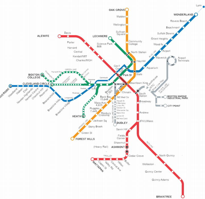
The Green Line was originally a balanced system designed to allow for trolleys from the west and south to terminate at Park St while trolleys from the northern suburbs would terminate at Scollay Sq (now Government Center). Ridership patterns quickly changed and more trolleys were routed between the two terminals. This created a bottleneck as the Green Line has 4 tracks between Boylston St (where lines from the west and south merge), originally 4 tracks between North Station and Gov’t Center, but only 2 between Park St and Gov’t Center. The Green Line morphed as higher ridership from the west required am extension to Kenmore St but ridership drop off from the south closed the southern portal at Pleasant St in 1963. Likewise ridership from the north changed and through a series of projects the Green Line from Gov’t Center to Lechmere was restructured to become a 2 track line.
As ridership from the west increased new branches of the subway were built but due to budgetary constraints their connections were built in such a way that created additional bottlenecks. The Green Line extension to Kenmore Sq had two western portals, one along Comm Ave (B Line) and another along Beacon St (C Line). When the Huntington Ave Subway (E Line) was built the connection was a simple at grade crossing meaning trains would have to wait for other trains to cross over before continuing. When the Riverside Branch (D Line) was added it was fused to the system with a similar at grade crossing on the C Line before Kenmore Sq. Modern subways use what’s known as a flying junction. If you’ve ever driven over a multi-level highway interchange it’s the same basic idea just with trains. This shortsighted way of expanding the system troubles the Green Line to this day. If a train gets stuck the whole thing is backed up. Ridership is only increasing as the Green Line is extended into Somerville and Medford.
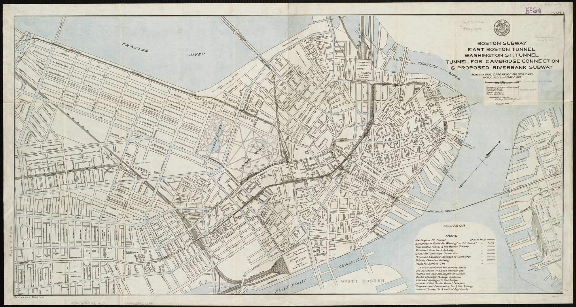
Interestingly a plan was put in place when the subway system was still being constructed 100 years ago that tried to address the growing ridership demand from the west headed into Park St. It was known as the Riverbank Subway and, as the name implies, would have ran along the Charles River where Storrow Dr is today. At the time the Charles River edge was not the landscaped jewel we know today but more a grassy embankment and promenade. The idea was to bypass traffic from Kenmore Sq to a terminal at Park St station. The subway would have most likely run above ground along the river which is why it faced stiff opposition. The plan was dropped in favor of the Boylston St Subway, the Green Line we know today.
What brings me to talk about this is a plan developed by Wentworth students that would resurrect the Riverbank Subway by extending the Blue Line from Bowdoin station to Kenmore Sq and then overtake the Riverside Branch, converting it from light rail to heavy rail. The plan is actually based on a previous plan proposed after World War II which would have converted most of the Green Line to heavy rail like the Blue Line (which itself was once a light rail line converted to heavy rail). These students have recently presented their proposal to MassDOT and worked out that it would ring in at around $3.3 billion. I would very much love to see the actual Power Point presentation of the plan but right now I’ve only read about it via BostInno. I commend these kids for doing what I never did, which is to meet with engineers and planners to see what it would take to get this going. However as someone whose looked at this concept for the better part of a decade I would like to offer my critique.
Firstly, if you are going to use my maps in your presentation have the professionalism to not Photoshop my copyright off the image. Isn’t plagiarism a huge problem in schools these days? Amazing. Also I was taught both Photoshop and Illustraitor at WIT so there is no excuse for the hideous map they produced.
Secondly, and more to the point, is that the Riverbank Subway only looks good on paper because the idea is to find a compromise between easing congestion while saving money which this plan to extend the Blue Line fails at both.
The subway itself would require digging up Storrow Dr to build a tunnel which would require extensive waterproofing and then weave through the Charlesgate to run along the Mass Pike before connecting to the D Line at Fenway station. Due to the fact that there does not seem to be a transfer at Kenmore nor Hynes station this would effectively cut off D Line riders from the Back Bay central business district (CBD) and require them to double back at Park St. At the very least a transfer at Kenmore Sq would have the intended effect by allowing anyone trying to get downtown from the west, whichever line they use, to bypass the Back Bay and anyone along the D Line would transfer to continue through the Back Bay. What good is added capacity if the capacity doesn’t help where it is most needed?
What’s more is that this plan does not even address the bottleneck issue other than removing D Line trains from merging at Kenmore Sq; E Line trains still back up the Green Line at Copley. The most this plan would accomplish would be to finally connect the Red and Blue Lines at Charles/MGH, a plan which has been studied to death at this point until some politician can come through and find the funds for it.
Then there is the cost. $3.3 billion actually seems like a reasonable estimate for such a project however it misses some very obvious costs related to converting the D Line to heavy rail. A quick estimate says the subway tunnel itself would be a bit over 2.5 miles long including three stations (Charles/MGH, Dartmouth St, and Yawkey Way). The students claim that this would not be another Big Dig except that most of the tunnel would require digging up Storrow Dr to build a tunnel under it… literally what the Big Dig did with the Central Artery. Traffic into and out of the city would be disrupted costing the city much more in lost revenue. Then there is something which it appears the students didn’t take into account: the D Line stations through Newton are not designed for heavy rail trains. Originally the Riverside Branch was a commuter railroad using steam engines. When it was converted for subway transit the line was electrified via overhead catenary wires which the Blue Line also uses. However, the original stations along the line were not built with high level platforms required for heavy rail. Thus all the stations would need to be rebuilt. Then there is the fact that when you have trains you need to store and service them somewhere. The Riverside Yards are the largest facility along the Green Line and until the new yards in Somerville are built for the Green Line Extension cutting off these yards would be devastating to the system. The yards themselves would need to be upgraded for heavy rail and new, albeit temporary, yards would need to be built somewhere else. Concurrently, you would also need to buy new trains for the Blue Line. Suddenly the price tag of $3.3 billion seems very low.
An Alternative Plan
Looking at these students plan it seems to me that they weren’t asking the right questions. When I sit down to concoct a new subway line I ask myself what can be designed to connect the most number of people with where they need to go via the most efficient route possible; a route that also addresses any congestion concerns and cost concerns by using existing infrastructure where possible. In this case you have thousands of commuters coming from the western suburbs funneling through a congested two track tunnel which offers neither express service nor redundancy.
Extending the Blue Line (with a connection at Kenmore Sq) would add capacity through the Central Subway but would also require a large amount of new infrastructure along the route (as I explained above). The alternative would be to then expand the Green Line itself. Creating a parallel Green Line tunnel through the Back Bay would provide the same intended relief to the Green Line by doubling capacity while at the same time utilizing existing infrastructure to save on costs.
Stuart St Subway
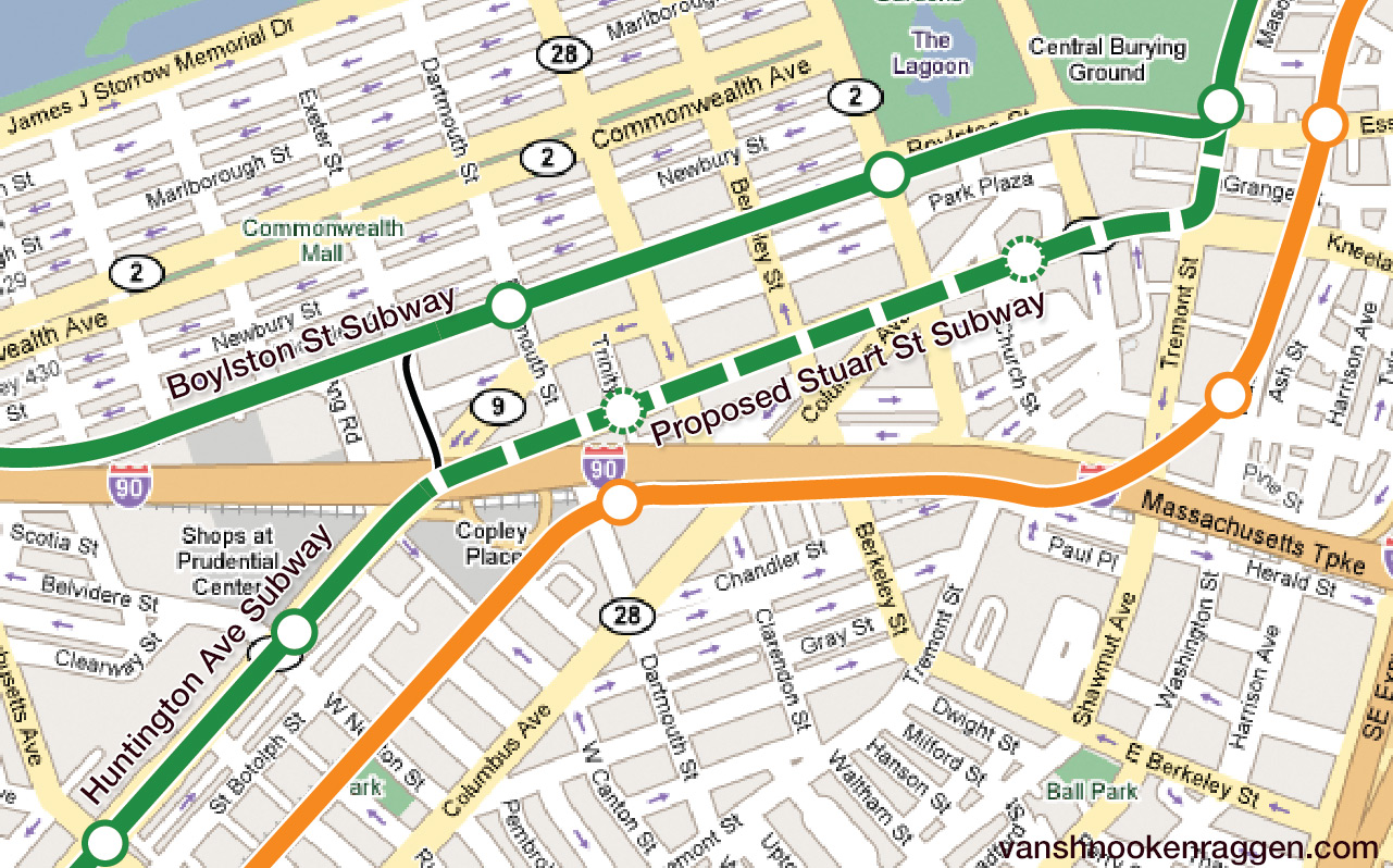
When you are traveling through Boylston St station you’ll notice two outside tracks which are now only used to store historic trolleys or the occasional work train. These tracks are part of the original subway and continue south under Tremont St to Eliot Norton Park where once existed a portal. This is the only instance along the Green Line where a flying junction exists for efficient operations and due to shifting traffic patterns has lain dormant for 60 years. Any new Green Line tunnel should use this junction to connect with the Central Subway. A new subway should run THROUGH the Back Bay, not around it, since this is the second heart of the city home to a major business district, intercity train station, and an ever growing area of high rise residences. Congestion here will only continue to rise so why should you build a subway to make working and living in the Back Bay harder? A subway under Stuart St from Tremont to Huntington Ave; such an alignment would mean extensive road work due to utilities under the street but using the street grid pattern of the Back Bay Stuart St itself could be closed off to traffic while construction occurs and auto traffic could be easily diverted. As Stuart St is not a major retail corridor the area would not be as adversely affected by construction as other major streets.
Huntington Ave Subway Extension
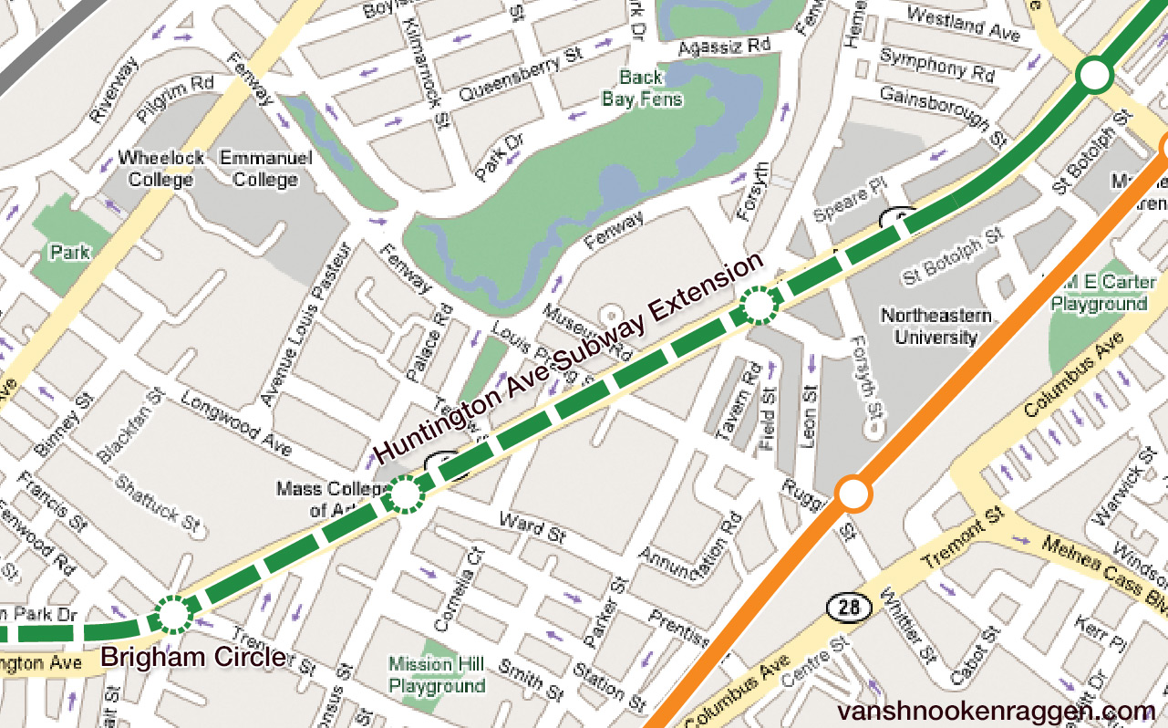
When originally planned the Huntington Ave Subway was meant to extend to Boylston St via Stuart St and then further west to an underground terminal at Brigham Circle. Due to shortages of money and material during World War II the subway plan was cut back to the short, awkward tunnel we have today which causes so much back up. The E Line was cut short in the 1980s when the MBTA stopped running trolleys to Arborway and ridership dropped. Even today many trains terminate at Brigham Circle instead of continuing on to Heath St.
Extending the subway to Brigham Circle and building an underground loop would remove all grade crossings along Huntington Ave, a corridor which over the last 20 years has grown considerably as the colleges of the Fenway expand. College students clog the trains and street grade crossings slow down trains which has a rippling effect on the rest of the system. Building a subway down Huntington Ave would improve traffic for all users and the median could also be opened up for bike and pedestrian traffic.
Brookline Village Tunnel
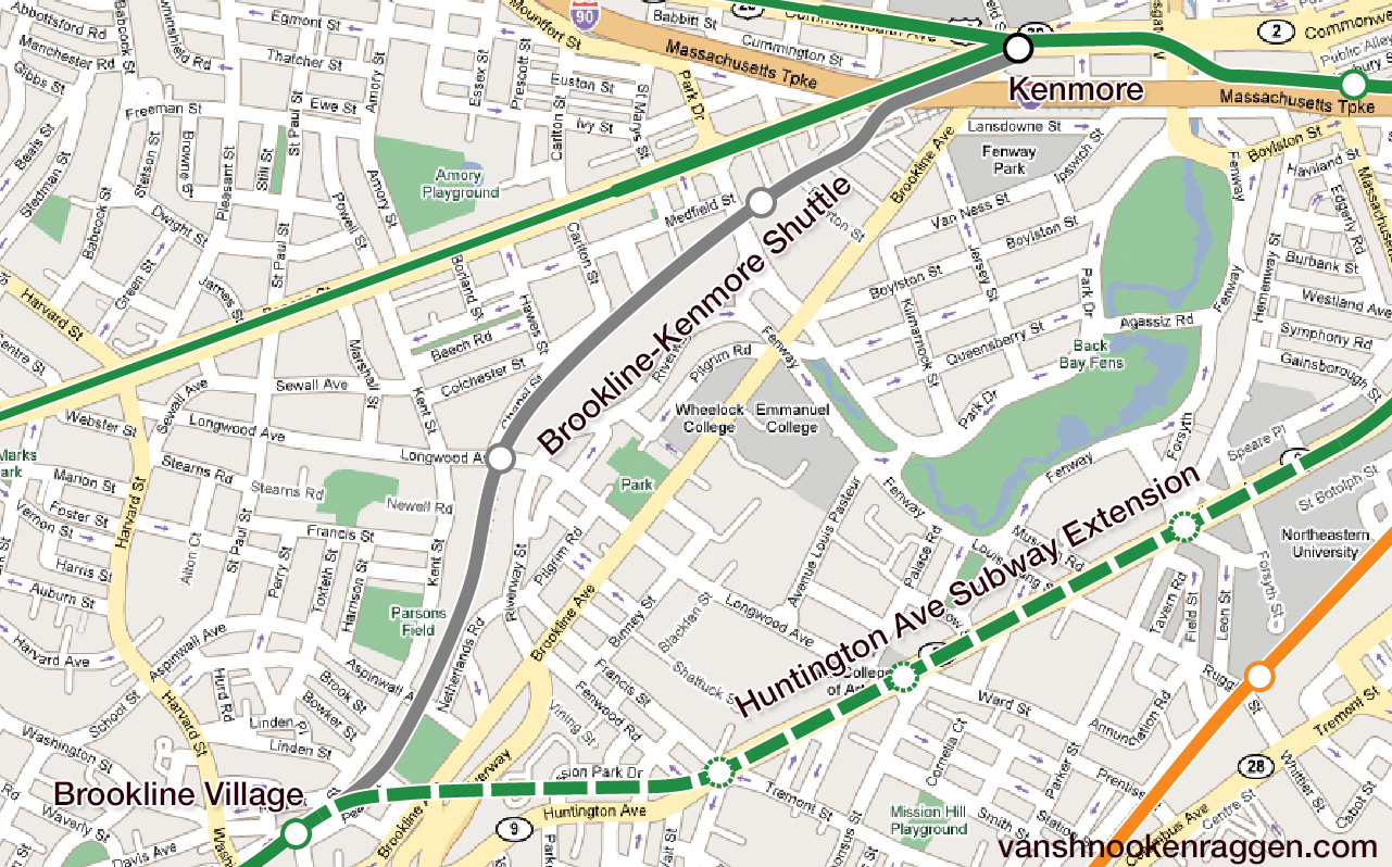
The final piece of this plan would to connect the Huntington Ave Subway to the Riverside Line via a new tunnel under Mission Park, the Muddy River at the Riverway, and Brookline Village. Between Brookline Village and Kenmore Sq would run a light rail shuttle to serve Longwood and Fenway station using the part of the Riverside Branch which is now cut off from the D Line. All traffic on the D Line would be rerouted along Huntington Ave and anyone needing to get to Kenmore Sq (especially for games at Fenway Park) could transfer to the shuttle. This connection would allow flexibility and redundancy along the Green Line.
A Better Bypass
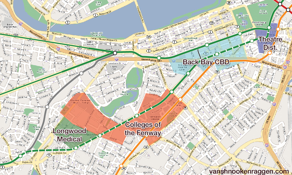
This new subway routing would solve all the problems that the Blue Line extension sets out to address but would do so at considerably less cost. While stations along the new tunnels would be expensive the savings would come from not needing to rebuild all the Riverside Branch stations or needing additional train yards. Instead of creating a commuter nightmare by sending riders around the Back Bay the new subways would connect riders to two of the most important business districts in the city, the Back Bay and Longwood Medical Area. The subway would take street running trolleys off the road and streamline operations as it would remove two of the major bottlenecks along the Green Line. Service could then be increased along the B and C Lines without compromising the D or E Lines. B and C Line trains would terminate at Park St using the inside tracks while D and E Line trains would continue north using the outside tracks at Park St, thus full utilizing the 4 tracks under Tremont St. Additionally, as the tunnels themselves would be built in sections each one would have an individual effect on the system while a Blue Line extension would need to work all at once.
Serving the most amounts of riders by running through two growing employment centers in the city while using existing infrastructure where it can means a much lower cost of construction and higher return on investment.
Kate Farrish liked this on Facebook.
Nicholas Torres liked this on Facebook.
Liam Sullivan liked this on Facebook.
@vanshnook per usual with a great @mbta vision http://t.co/82fDLFp8X0
Phil Boucher liked this on Facebook.
Mike Russo liked this on Facebook.
So do E line trains no longer go to Heath Street in this plan? JP residents won’t like that!
Having been at the presentation I have to say you’ve mischaracterized their proposal tremendously. The students are proposing a blue line extension that connects to Park St after Government Center, tunnels underneath the Common and the Public Garden, continues under Newbury Street with stops at Darmouth (connecting to Copley) and Hynes (connecting to the existing Hynes Station), continues south under Brookline Ave with stops at Yawkey, Riverway, and Longwood before tunneling under the Muddy River to connect to the D branch at Brookline Village. All of this would be completed with two 20′ diameter tunnel boring machines (TBM) to avoid impacts to surface streets. Bowdoin Station would be eliminated. They assumed a per-mile cost for tunneling based on other projects, and they also assumed several hundred million per underground station (it was either $250 or $500 million per subway station). They did factor in the cost of reconstructing the D Branch stations; I think $50 million per surface station. They’ve thought about soil composition and have determined that it’s feasible to tunnel this path. They’ve factored in going under the parks, going under I-90, and going under the Muddy River both at Riverway (where they’ve factored in the depth of the infrastructure of the construction going on at this location now) and near Brookline Village. They’ve even thought of where they’d stick the TBM (near the Newbury Street I-90 on-ramp). I have to give them credit for really thinking this through.
You do point out some good pieces of information, specifically the issue of the yard and the issue of the E branch crossing the tracks at Copley. They’d be the first to admit that they don’t have all the answers (they are, after all, geotechnical engineering students, not transportation planning students, so this is mostly a tunneling exercise for them), so they sought input at the YPT presentation this summer.
I have problems with portions of their proposal as well. I’d prefer that the tunnel did continue past Bowdoin to connect to Charles, but then follow Storrow until it could come into Back Bay and connect to Copley, and then continue under Newbury Street as they have proposed. I think a Charles/MGH connection is really needed, but I think their alignment west of the Public Garden is really smart. I would prefer to see a connection at Kenmore as well, but that area might be very tricky to get right.
Personally, I don’t think you’re proposal would offer nearly as much benefit. All it does is eliminate the E branch from crossing over. It forces anyone taking the D or E branches to go all the way to Boylston to transfer back to the B or C branches (unless there’s a pedestrian tunnel at Copley). It removes rapid transit access from Fenway, and pushes LMA employees who depend on the Longwood Station farther away. I’m not really following what you mean by light rail shuttle. For all the money that this would cost, what is really being gained? If we’re going to spend money tunneling under Back Bay, it most certainly should be to extend the Blue Line. Yeah, the annoying crossover at Copley would still happen with the E branch, but with D trains removed, better service can be provided to the remaining three branches. Plus the Blue Line is tragically underutilized. The line is operating at something around 30 to 40% capacity, while all other lines are exceeding capacity (green) or approaching capacity (red and orange).
Side note, I’m not associated with the student proposal at all. I just thought I should bring you up to speed with its actual contents.
First let me thank you for giving me more insight into the proposal. I emailed the professor of these students asking for more information and he never responded. However, even knowing more about it, I still think my proposal is superior (though I do want to give these kids credit for coming up with a well thought out idea).
Let me explain something about my proposal which I think you are missing: I’m not suggesting that the Fenway section is to be eliminated but rather it would be replaced with a shuttle between Brookline Village and Kenmore Sq. While through service to downtown would be eliminated no stations would be abandoned. Anyone traveling from Brookline can still get to Kenmore Sq via the shuttle or Copley Sq via the new tunnel, which as others have pointed out, is only two short blocks away from the existing Green Line. This new service wouldn’t require anyone to travel to Boylston to back-track; they’d just take the new subway to the same streets but a quick 2 block walk away. Boston isn’t that big. The operational advantages to my plan would out weigh any small inconveniences.
Any new tunnel under the Back Bay would increase capacity but my point is why not kill two birds with one stone? A Blue Line extension would cost millions and we’d still have to deal with all the Green Line bottlenecks. A new Green Line tunnel would address both.
I have to agree with Nick here. Extending the Blue Line increases the number of one-seat rides, doubles capacity within back bay, allows several connections which don’t currently exist, and also helps alleviate (although not solve) the lack of flyovers. The extended Blue Line from government center could connect at Park Street, then run down Comm Ave with between track stations (minimal head-houses) at Clarendon and Gloucester. It could then connect at Kenmore (Green Line & bus depot) and Yawkey (commuter rail) before connecting with and using the current D-Line tracks to serve these stops. Not that any of this is fiscally possible (see GLX). Side note: to save money, the GLX should cut the Union Square stop.