


This is something I’ve been wanting to do for a long time but didn’t know how to start. I present my Google Maps version of the proposed Lower Manhattan Expressway and Mid Manhattan Expressways. (I didn’t know how to draw maps to look like Google Maps but it’s pretty easy.) Now there have been maps showing these proposed highways before (they are included in my Unbuilt Highways Map of NYC) but the point of doing it up to look like a Google Map was to put these highways in a modern context (also I’m sure there are plenty of people who didn’t even know about these). We have become so accustomed to viewing the world through Google Maps (or some other online mapping software) that I feel like these maps are starting to shape our view point of the city.
A map, after all, is a representation of reality with certain things omitted (or in this case, added). As mapping software becomes even more ubiquitous now that they are in the palm of our hands (Blackberrys, iPhones, etc), I think it will become all too easy for people to just accept what they see as reality. This is a dangerous prospect but one I think can be taken advantage of when trying to communicate certain information, such as what a neighborhood you know pretty well would look like with an elevated highway slammed through it. This was true for me, at least, while I was making these; Hand erasing buildings through SoHo, TriBeCa, and the LES was an eery experience as I tried to imagine what these places would really look like if my brush was a bulldozer.
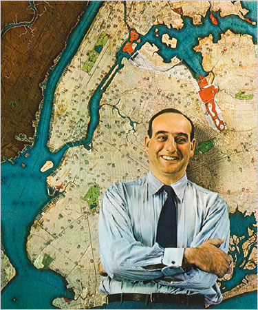
And thus I began to understand the failing of Robert Moses (well, this one anyway). He didn’t drive and lord knows he didn’t think much of these areas which he tossed off as “slums”. Â There is a famous image of a young Moses standing in front of a map of the entire city (to the left).
What you need to be aware of when you are looking at a map is how it lies to you; it is a seductress. You think because it represents reality you can better understand reality, which is true only to a point. But when combined with the power and ambition of Robert Moses the maps seduction warped him and let him think that a line across the map represented far less chaos and destruction than he perceived. Adjusting lines on a map is easy and because a map is a visual design adjusting lines seems like a good way to clean up the map. But the lines on a map hide the fact that they represent something real, a street that needs to be moved, houses that need to be knocked down, families and businesses that need to be kicked out. I’m not saying that Moses wasn’t aware of these things, in fact he was keenly aware. But it was so easy and sexy to clean up the map that he was willing to do whatever it took to draw his maps to be permanent.

Thank for creating these images.
Have you considered doing one for the tunneled version of the Mid Manhattan Expressway rather then the elevated version?
I hadn’t thought of it but I think the map would look pretty much the same.
Wonderful maps. I really appreciate your work on these maps. I read about Moses many years ago, and how the Cross-Bronx and other projects of his really hurt the City more than helped it. Thanks for putting a new perspective on things!
Now for the street view 🙂
Love the MBTA maps and Moses maps. I’ve been sketching these in my bedroom for years, but your artistic ability far surpasses mine. How about showing us the Bushwick expressway? I could use that on the way to JFK, for sure.
Thanks! That’s on the to-do list along with the fully built Sheridan Expressway in the Bronx.
unless I missed it, you didn’t include the highway he planned from the Rockawas to Montauk. Only two miles, four-laned with a grass island in the middle, were built, rnning from 103rd to 73rd St., in Rockaway Beach, where it is called the Highway to Nowhere.
If you are talking about the Shore Front Parkway then I did include it, though I didn’t extend it out to Montauk. Guess I hadn’t head about that part.
I write about different ways of reorganizing history and knowledge, the “what ifs” that pepper the landscape, also the if onlys. (I’m a mapmaker and author.) Stubbornness and parochialism for once worked to NY’s advantage. Haussmann’s Paris was an improvement, but Moses would have destroyed NY.
I should add that this same seduction of the planner’s drawing or model also works on people through architect’s drawings, now done magically on computer. A huge cold carbuncle of a building with no street level interest, cheap detailing and brutal scale can look awfully charming on a computer screen or on an easel in a public meeting. The one-touch changes and substitutions made on a computer model can also make a pig’s breakfast of a coherent plan. Beware the words “simple”, “improvement”, and “comprehensive”. I admire artistic genius and big ideas but each new big idea doesn’t make the previous one obsolete.
Moses left his mark up here in Buffalo as well, slicing into an Olmstead Park, among other things.
From what I understand, both the Sara Roosevelt park and the St. Gabriels park were planned as right of way for the expressways. I believe St. Gabriels was even bought. Your map has the highways running alongside the parks.
No this is incorrect. Both parks were there long before any planned expressways and neither were to be used as ROW.
Cool and useful. How about one for Brooklyn?
Totally working on it.
Could you share a bit more information about how you created these images? Thanks.
I’d love to see a whole series of these things for other urban plans in U.S. cities that were never realized (like the inner beltway in D.C., for example).
So would I and that’s why I’m working on it.
Hello,
where did you get the image of Moses?
Google.
Robert Moses was once quoted as saying “I love humanity. I hate people.” I think that says it all. He was also a major factor in the Dodgers leaving Brooklyn.
Robert Moses was a very smart man but a “F&%king idiot at the same time!!!!
I have started reading about Robert Moses recently and find his work very interesting. My mother grew up on Long Island and mentioned a once proposed elevated highway through Central Park. I have yet to figure out the name of this highway, or if it even existed. Can you help clear this up for me?
I stumbled upon this, and found it very interesting. I’m originally from the Rockaways, and have been an architect practicing in Washington, DC for about twenty years. The legacy of Robert Moses’s vision and blind spots, like almost every aspect of his unbelievable career is almost endlessly fascinating — thanks so much for adding something so vivid and tangible to the discussion.
Can you please do an image of the Gowanus Expressway as a tunnel with a treelined boulavard on top.
Tear down the Gowanus!
You think you could do a map of another Moses project that didn’t happen?: The Riverfront Expresway/I-310 in New Orleans, which would have plowed through the French Quarter.
No Philadelphia on your unbuilt maps?? I really like what you created though.
Maybe also try parts of NJ.
Thank you for creating these maps. Would you consider doing a map of the unbuilt Bushwick Expressway?
Yes, actually, I was working on a huge map of all the unbuilt Robert Moses highways but got distracted by life. I’ll get around to it eventually.
So glad that never actually happened. Man oh man…….he also wanted to turn Fire Island into a highway. Also very glad that didn’t happen.
the post menupasual slut who hated cars jane jacobs and the GERIATRIC WEASEL robert caro are the reason listen up stooge n.y. is the INFRASTRUCTURAL TOILET BOWL OF AMERICA I asked the SYNCOPHANT AT THE WHOREHOUSE IN MORNINGSIDE HTS. WHEN was the last time your stupid state even built a major monumental bridge ? need a hint ? GO BACK to the first world TOUR OF THE BEATLES AT SHEA STAdium! no WONDER N.Y. IS THE INFRASTRUCTURAL TOILET BOWL OF AMERICA NO WONDER THE COFFERS $$ OF THE STUPID STATE OF N.Y. ARE EMPTY LOOK STOOGE the most appropriate symbol of the RESULT OF THIS MALFEAISANCE AND CRIMINAL NEGLIGENCE how about the GARBAGE BARGE A PICTURE OF THAT THAT BLASPHEMOUS BARGE remember 1987 and that atrocious blasphemous barge docked in GRAVESEND BAY BROOKLYN SHOULD BE SUPERIMPOSED ON EVERY LISENCE PLATE IN YOUR STUPID STATE EMPIRES need empire builders such as the greatest monumental infrastructural infrastructural ENGINEERING CIVIC EPOCAL TRANSGENERATIONAL GENIUS OF THE LAST 1000 YRS robert moses THE PUSSILLAMINOUS PIPSQUEAKS FROM THE NASSAU COUNTY planning commission SUCCUMBED TO THE SIREN SONGS OF THE POST MENUPASUAL SLUT WHO HATED CARS jane jacobs and the GERIATRIC WEASEL robert caro who still lives in SODOM and works part time for the NOXIOUS N.Y. TIMES a paper i reserve for the PARAKEET CAGE. HERE is the THEME LONG ISLAND 1973 GOLD COAST TO TRASH COAST 2013!OH BY the way since this wealth creating $$$$$$$$$ job producing $$$$$$$$$ tourism TOURISM get it stooge TOURISM $$$$$$$$$$$$ RYE OYSTER BAY BRIDGE WAS HALTED the SCUMBAG CONGRESSMAN FROM GLENCOVE LESTER WOLF MUST BE GIVEN CREDIT HERE LONG ISLAND IS THE BIGGEST DEMONIZED IMMOBOLIZED CRIMINALIZED DEPAUPERIZED DEATHTRAP IN THE COSMOS THANX TO THE UNBUILT UNBUILT RYE OYSTER BAY BRIDGE MILLIONS OF POOR SLOBS MOTORISTS must now SCHELPP their way out of this man made self perpetuating DEATHTRAP ON THE WORLDS LONGEST PARKING LOT 495 THE NOTORIOUS LONG ISLAND DISTRESSWAY TO SODOM! THERE IS NOW NOW NO NORTH SOUTH EVACUATION ROUTE BECAUSE THE scumbag congressman whose house of LARGESS just happened to be in the path of this massive monumental epocal transgenerational ENGINEERING MIRACLE hmmmmm sounds like a slighr case of a conflict of interest here maybe! miss plastic who also works at the WHOREHOUSE IN MORNINGSIDE HTS. SHE ASSISTS THE SYNCOPHANT and makes lucrativo $$$ i told her to BUY A BMW CONV. LISTEN UP STOOGE YOU WOULD LOOK STUNNING IN A BMW CONV. I TOLD THE SYNCOPHANT YOU SAY ANYTHING negative about the post menupasual slut who HATED CARS or the geriatric weasel CARO AND THEY WILL THROW YOUR ASS OUT OF THE WHORE HOUSE IN 72 HOURS TENURE AND ALL!BUT THEN MISS PLASTIC said to me come on relax will u please o.k. so the stupid state of n.y. skipped the CRITICALLY CRITICALLY NEEDED CROSS SOUND LINK that was over 40 yrs. ago so just get over it and get on with your life now stooge remember our theme LONG ISLAND GOLD COAST 1973 TO TRASH COAST 2013 MY MOTHER had a spoiled stink,in flea bitten poodle named SANDY.
I see an alternative design for the LME connecting the Williamsburg Bridge with the Holland Tunnel, as a cut and cover tunnel beneath new buildings east of the Bowery, and then further west as a stacked tunnel beneath Broome Street in order to avoid the Cast Iron buildings.
http://cos-mobile.blogspot.com/2013/12/for-cast-iron-friendly-lower-manhattan.html
That is a colossal waste of money that will still only help some guido get form NJ to Brooklyn. The billions that would cost would be more effective spent on transit or renovating existing highways.
Hey, How do you make these kind of maps. Is it some kind of software?
I use Adobe Illustrator mostly.
do you think you would sell these maps in the near future?
Not these ones because of the Google copyright but eventually I plan to draw my own original ones and sell them. That was actually why I put these on the back burner for so long but then decided to release them anyway.
wow these look great… too bad they were never built… it would cut my drive down so much through the city and what an amazing few you’d get from the elevated highway!
Very nicely done and very well put.