
Quick Index
- 2nd Ave Subway
- South 4th Subway
- Utica Ave Subway
- Nostrand Ave Line
- Myrtle-Central Aves Trunk Line
- Rockaway Branch and Winfield Spur
- 3rd Ave El Replacement
- 9th Ave El Connection
- Van Wyck Blvd Line and Archer Ave Lines
- IND Fulton St Line Extension
- IND Ft Hamilton Line and Staten Island Tunnel
- Flushing Line Extensions
- Long Island City-Horace Harding Line and Long Island Expwy Line
- Midtown-Queens Tunnel and Super-express
- Morningside Ave Line and Bronx Super-express
- IND Concourse Line Extension
- IND Hillside Ave Extension
- BMT Canarsie Line Extensions
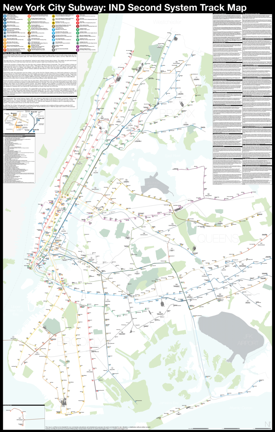
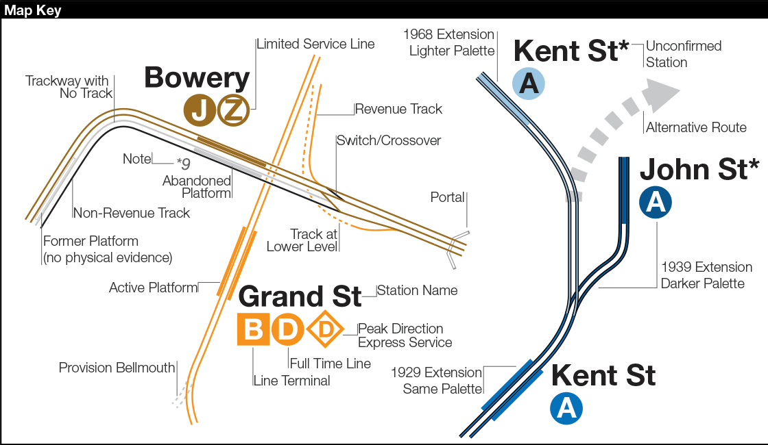
All the descriptions bellow are also written on the map itself. This page is provided as an easy to reference guide. Reference numbers on the map correspond to the ones here.
How to read this map
The purpose of this map is the show the history of official subway expansion plans which can be broadly broken down into four phases: the 1929 Second System plan, the 1939 Second System plan, post-World War II plans, and the 1968 MTA Plan for Action.
The map acts as a “choose your own adventure” where by each variant of every plan is drawn. The reader can pick and choose which lines they think could have been built and what the system might have looked like today if they had.
To show the evolution of these plans over time this map contains different layers of proposals. The current system is drawn as is but proposed lines are drawn with a black outline. 1929 plans are drawn with the same color pallet as the present system, 1939 plans are drawn in a darker color pallet, and post-War to Plan of Action lines are drawn in a lighter color pallet. Also shown are heavy, grey dashed lines which indicate additional alternatives to the main proposals which were not drawn out in detail for the sake of overall clarity.
Some lines were only proposed once but others, such as the 2nd Ave Subway (drawn as a full 6-track subway) or Utica Ave Subway (drawn as a full 4-track subway), have had multiple proposals over the years which have changed in scope. These lines are drawn as they would look at their largest scopes. Alternative arrangements are drawn branching off the main lines. This is to show different alignments and not to suggest different branches of the same proposal. Some lines show two totally different services at the same time to indicate how service would have differed under alternative plans.
Tracks and station details for much of the map are speculative. Most extensions were only proposed as grand concepts. Some were not serious proposals but added to build political support for the plan. Few ever got to the engineering stage when actual designs were drawn up and station locations chosen. Any station labeled with an asterisk (*) is based not on actual blueprints but where the author presumed planners would have placed one. Likewise, interlockings and track layouts, for the most part, are designed in keeping with how typical IND interlockings and tracks were laid out at the time.
Train routes are also based on speculation. The original IND route naming convention had express trains labeled with single letters (A, E, F) while local routes were labeled with double letters (AA, CC, GG). This convention was simplified to the one we have today in the early 1980s and all proposed extensions are labeled with the modern convention. Exact route labeling, if not evident by historical precedent or determined by track layout, is completely speculative and should be viewed as purely for illustrative purposes.
Background
The Independent City-owned Subway System, IND, was created as alternative to the private traction companies, Interborough Rapid Transit Co., IRT, and the Brooklyn-Manhattan Transit Co., BMT. The IND broke ground on the 8th Ave Line in 1925 with plans for lines to Queens, Brooklyn, and the Bronx. In 1929 the IND released an ambitious plan for expanding the initial system. This plan became known as the IND Second System. In 1940 the City of New York was able to purchase the private companies and combine all three systems under the NYC Board of Transportation. In 1953 this evolved into the NY Transit Authority and in 1968 the state took control of the subways as part of the Metropolitan Transportation Authority.
1: 2nd Avenue Subway (1929-Present)
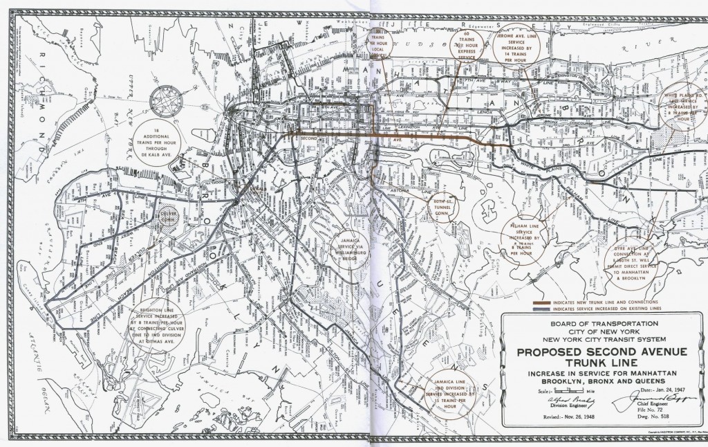
The 2nd Ave Subway has been at the heart of every expansion proposal since the IND Second System was first announced. The line has been redesigned countless times, from a 6-track trunk line to the simple 2-track branch we have today. The map depicts the line as proposed in 1931 with 6 tracks from 125th St to 23rd St, a 2-track branch through Alphabet City into Williamsburg, 4 tracks from 23rd St to Canal St, a 2-track branch to South Williamsburg, and 2 tracks through the Financial District to Brooklyn via the IND Fulton St Line.
Scaled back alternatives eliminated the Alphabet City branch in favor of a connection to the East Houston St extension of the IND 6th Ave Line to Williamsburg (1930s) or a connection to the Williamsburg and Manhattan Bridges (1940s-1950s). Current plans dating from the 1970s would see a 2-track line from 125th St to Hanover Sq in the Financial District with cross platform transfers at the Grand St station (which was designed for a future 2nd Ave expansion). An alternative was also proposed which would have connected the 2nd Ave Subway to the BMT Centre St Subway (J/Z trains) which would have allowed 2nd Ave trains to reach Brooklyn via Broad St and the Montague Tunnel.
In the Bronx the 2nd Ave trunk line was designed to replace service on the IRT White Plains Rd Line. The subway was to run along 3rd Ave and Boston Rd to E 180th St station. The IRT was to be cut back to the Bronx Park Terminal (demolished). Additionally, two branches were proposed: the first through Soundview to Throgs Neck via Lafayette Ave, and a second along Morris Park Ave to Wilson Ave. This second branch was eliminated when the city purchased the New York, Westchester & Boston Railroad and incorporated it into the subway as the IRT Dyre Ave Line. Subsequently, it was proposed to include this line as a branch of the 2nd Ave Subway. As part of the 1968 Program for Action it was proposed to connect the 2nd Ave Subway to the IRT Pelham Line at Whitlock St station, increasing capacity on the line with larger trains, and cutting the 6 train back to Hunts Point station.
In Brooklyn the 2nd Ave Subway was designed to connect to the IND Fulton St Line local tracks at Court St station (today the NY Transit Museum). In Williamsburg a branch was proposed in the 1930s between 2nd Ave and the South 4th St station. At various times from the 1930s-50s a branch was proposed from Grand St in the Lower East Side to Williamsburg to feed into a 4-track subway along Bedford Ave in Brooklyn. This Bedford Ave Line is often referred to as part of a “Third System” but no definite plans were ever released. It is possible it was designed to connect to the BMT Brighton Beach Line or IRT Nostrand Ave Line.
2: South 4th St Line (1929-1939)
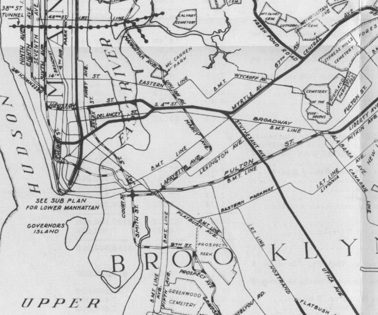
The South 4th St Subway trunk line was the second major part of the initial IND Second System. The project was designed as a major traffic artery, involving a complex network of tunnels and stations as well as a new boulevard between the Williamsburg Bridge and Bushwick Ave. Riders from Brooklyn would meet with Queens before being redistributed through Manhattan.
The IND 6th Ave Line would be extended from 2nd Ave station along East Houston St, under the East River, and curve under private property to South 4th St in Williamsburg. A branch off the local tracks of the IND 8th Ave Line between Canal St and Chambers St would curve east under Worth St and East Broadway, then under the East River to South 4th St. A future connection was planned for a third tunnel between the IND 2nd Ave Line and South 4th St along Stanton St in the Lower East Side.
The trunk line would feature 6 tracks from Havemeyer St to Bushwick Ave. 4 tracks would turn south to Utica Ave and 2 tracks would swing east to Myrtle Ave. A 2-track connection between the IND Crosstown Line at Bedford-Nostrand Aves and the Myrtle Ave branch at Knickerbocker Ave, along Lafayette Ave and Stanhope St, was included as well. By 1939 the Myrtle Ave branch had been eliminated from the plan.
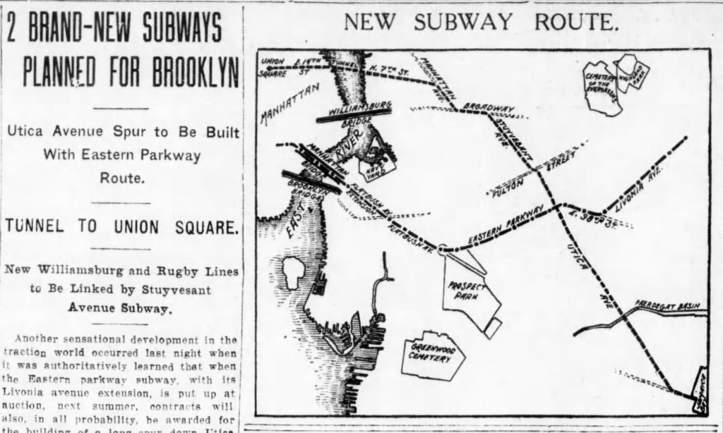
In the 1930s two other alternatives were proposed. The first was to incorporate the BMT Jamaica Line into the system with a new East River tunnel replacing tracks on the Williamsburg Bridge and connecting to the elevated tracks on Broadway southeast of Myrtle Ave. The second was an alternative to the Myrtle Ave branch, a 4-track line branching off the South 4th trunk along Flushing Ave. This would have run along an undisclosed route to Queens Blvd and Horace Harding Blvd, today the Long Island Expressway. It is assumed this would have continued east to the Nassau Co. border.
3: Utica Ave Line (1910s-Present)
A subway or elevated line along Utica Ave in southeastern Brooklyn was proposed early on in subway expansion plans of both the IRT and BMT. The BMT advanced it as an alternative to or branch off the 14th St-Canarsie Line (L train). The IRT went so far as to design its Eastern Parkway Line (3,4 trains) for a future extension south along Utica Ave. When the city created the IND system it took over all previous proposals. A trunk line along Utica Ave was then proposed as part of the IND Second System.
As part of the 1929 and ’39 plans the 4-track Utica Ave Line would have branched off the South 4th Line at Bushwick Ave and Melrose St, cutting south to Stuyvesant St where it would run to Fulton St. The Utica Ave station on the IND Fulton St Line was built with a shell station for the future subway.
South of Fulton the line would run under Utica Ave to Kings Highway. Here the local tracks would terminate and the two express tracks would continue south, rising from the subway to an elevated line. The 1929 plan called for the tracks to turn southwest at Flatbush Ave and run along Ave S to Nostrand Ave where it was to meet an extension of the IRT Nostrand Ave Line and continue to Voorhies Ave together. By 1939 this had changed to continuing the line along Flatbush Ave, running to Floyd Bennett Field instead.
After World War II proposals for a Utica Ave Line were shrunk from a 4-track trunk line to a 2-track branch off of either the IND Fulton St Line or the IRT Eastern Parkway Line. As recently as 2015 a subway along Utica Ave had been actively proposed.
4: Nostrand Ave Line (1910s-1970s)
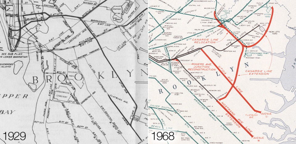
The IRT Nostrand Ave Line runs from Eastern Parkway to Flatbush Ave-Brooklyn College as a 2-track subway. It was always designed to continue south, a fact which causes the “temporary” terminal at Flatbush Ave to function poorly enough that it reduces system capacity. Most proposals over the years called for the subway to ascend to an elevated line and run south to Sheepshead Bay. Residents of Midwood and Sheepshead Bay have called for such an extension but were unanimously against an elevated line. Engineers said that the sandy soil, so close to the ocean, created drainage problems in the tunnels and would be too expensive to build. An alternative as part of an amended 1968 Plan for Action called for the line to be extended along Flatbush Ave to Ave U instead, which acted as a compromise between building both this and the Utica Ave Line.
All proposals included a plan to rebuild the Rogers Junction, the connection between the IRT Eastern Parkway Line and the IRT Nostrand Ave branch which, because of poor design, creates a bottleneck in the system.
5: Myrtle-Central Aves Trunk Line (1929)
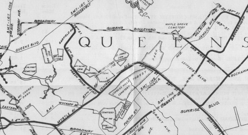
A 4-track trunk line was proposed to replace the elevated BMT Myrtle Ave Line (M train) and connect central and southern Queens with Manhattan via the IND South 4th Line. 2 tracks would branch off the South 4th Line at Myrtle and Bushwick Aves. A second pair coming down Lafayette Ave from the IND Crosstown Line would connect at Stanhope St and Myrtle Ave. 4 tracks would continue east along Myrtle Ave and then Central Ave to Cooper St where the line would come to the surface and run alongside the LIRR Lower Montauk Line to Woodhaven Blvd. After Woodhaven Blvd the line would turn south and run parallel to the LIRR Rockaway Beach Branch.
4 tracks would continue south to Conduit Blvd where the line would branch: 4 tracks continuing south to Howard Beach and the Rockaways, and 4 tracks turning east along 120th Ave to South Jamaica. The 120th Ave Line would have run along an elevated embankment cutting diagonally through the street grid. Local tracks would have terminated at Van Wyck Blvd while the express tracks would continue east until they terminate at Springfield Blvd.
6: Rockaway Branch and Winfield Spur (1929-Present)
Service to the Rockaways via the subway was first provided by the Brooklyn Rapid Transit Co. in 1898, running until 1917. BRT trains ran over the Williamsburg Bridge to East NY where a track connection to the LIRR Atlantic Branch allowed elevated trains to continue to the Rockaways.
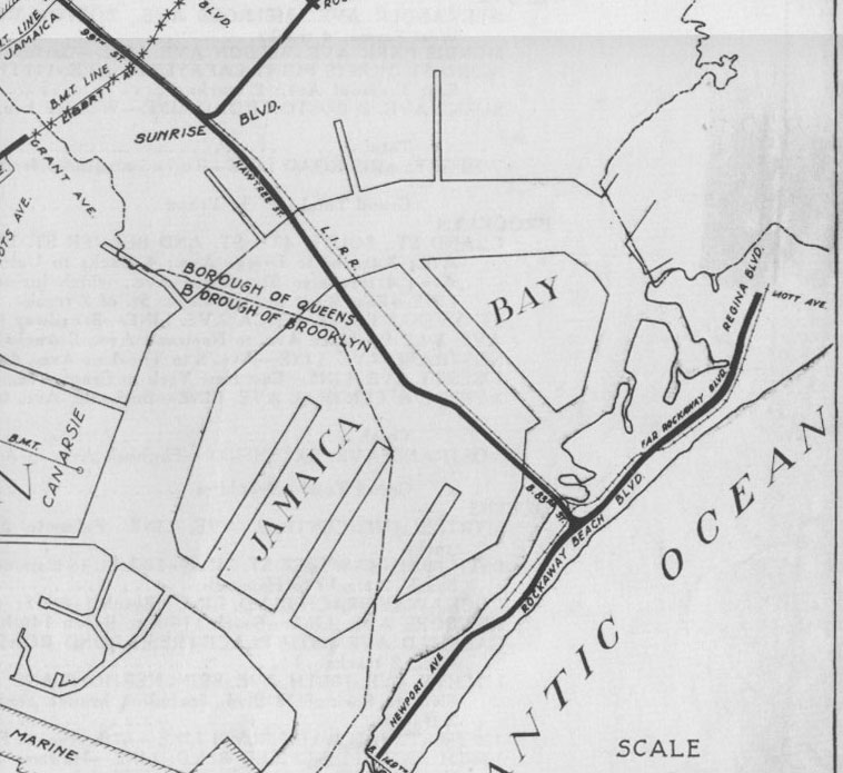
In 1929 the IND proposed connecting the Rockaways via the Myrtle-Central Aves Trunk Line. South of Howard Beach the 2 tracks would run along a new right-of-way parallel to the existing LIRR Rockaway Branch (A train). On the Rockaway peninsula the elevated line would have run along Rockaway Beach Blvd with one branch going to Mott St in Far Rockaway and another running first to 116th and then to 149th St via Newport Ave. The LIRR line was not elevated at the time which may explain why the IND proposed separate tracks.
The Winfield Spur was a proposed connection from the Rockaways to the IND Queens Blvd Line via the Myrtle-Central Aves Trunk Line. A terminal platform and trackways were built for such an extension at Roosevelt Ave station on the IND Queens Blvd Line. The 2-track line was to run from Roosevelt Ave south along 78th St to a portal near Queens Blvd and then elevated southwest to 65th St in Maspeth. Running south along 65th St the line would dive into a subway under Fresh Pond Rd and continue south to Cypress Hills St where it would merge with the Myrtle-Central Aves Trunk Line. The line was designed to run into Manhattan via the IND Queens Blvd Line when a second East River tunnel was built.
By 1939 service to the Rockaways was greatly simplified. Proposed was a simple 2-track branch off the IND Queens Blvd Line between 63rd Dr and 67th Ave running south along the LIRR Rockaway Beach Branch (which was to be purchased by the city in 1952). The IND Rockaway Line, as it became, was also intended to connect to the IND Fulton St Extension at Linden Blvd. The extension was never built and because there was not yet a second East River tunnel connecting to the IND Queens Blvd Line (the 63rd St Tunnel would not be connected until 2001) the Rockaway Line was only connected to the IND Fulton St Line along the elevated Liberty Ave Line.
After World War II proposals for connecting the IND Rockaway Line to northern Queens and midtown Manhattan involved building a new East River tunnel anywhere between 57th St and 79th St. This would have provided the additional capacity for such a branch. Alternatives included the Rockaway Line as part of a super-express subway which would have run parallel to the LIRR Main Line. As of 2019 the MTA has studied connecting the Rockaway Branch with the IND Queens Blvd Line but not made any recommendations for building it.
7: 3rd Ave Elevated Replacement (1940s-1968)
Service on the 3rd Ave Elevated Line began in 1878 and once stretched from South Ferry at the tip of Manhattan to Wakefield in the Bronx on the border of Westchester Co. The IND 2nd Ave Subway was designed to replace the aging structure, as well as an elevated line along 2nd Ave. In the 1940s the 2nd Ave El was demolished. After World War II plans were proposed to cut the 3rd Ave El back to 149th St in the Bronx and connect it to the 2nd Ave Subway. The elevated line was cut back by 1956 but no replacement subway was built, leaving riders to transfer to the 2 or 5 trains at 149th St.
By the late 1960s it was evident that years of neglect had made repairing the 3rd Ave El too expensive. As part of the Plan for Action the 3rd Ave El was to be completely demolished and replaced with a subway running alongside the New York Central RR tracks (now Metro North) from 149th St to Wakefield. The main proposal called for breaking the 5 train off from the IRT Lexington Line north of 138th St station as a new branch north. The 2nd Ave Subway was to provide replacement service along the Dyre and White Plains Rd Lines. The 3rd Ave El was eventually torn down in the 1970s but no replacement subway was ever built.
8: IRT 9th Ave Connection (1939)
The 9th Ave El was the very first elevated line in New York, opening in 1868. The line was extended north multiple times until it reached its terminal at 155th St and 8th Ave (Frederick Douglas Blvd). When the IRT Jerome Ave Line (4 train) was built the 9th Ave El was extended on a bridge over the Harlem River to a tunnel under Highbridge in the Bronx where it came to the surface at 163rd St and merged onto the new tracks.
In 1940 the 9th Ave El was demolished from South Ferry to 155th St. The 155th St-Jerome Ave section was kept to serve the Polo Grounds and New York Central RR Putnam Branch which terminated on the Bronx side of the river. Looking to expand capacity on its line in the Bronx, the IRT proposed connecting its Lenox Ave Line (the 3 train, which terminated at 145th St) to the Jerome Ave Line via the remaining 9th Ave El. Engineers found that it would have been too expensive to retrofit the bridge and tunnel for subway operations and the idea was dropped. In 1968 a new terminal was built in the IRT train yards at 148th St.
9: Van Wyck Blvd Line and Archer Ave Lines (1929-1939, 1968)
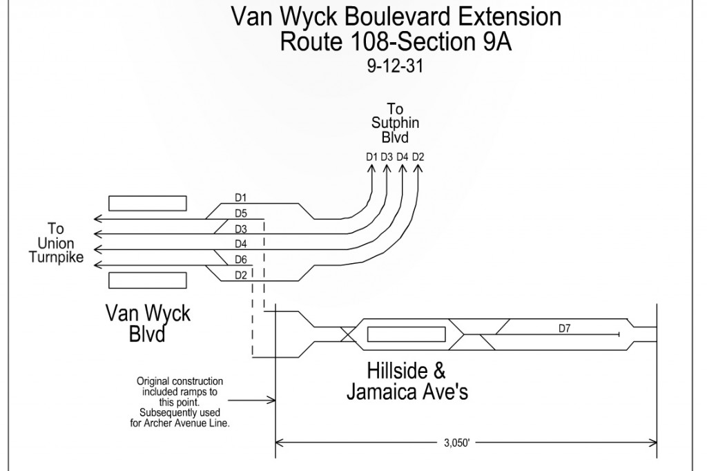
When the IND Queens Blvd was built between Forest Hills and Jamaica it featured provisions for a branch splitting off south of Briarwood station along Van Wyck Blvd to Rockaway Blvd. This 2-track line was to run as a subway until 116th Ave where it would run elevated. In the 1929 plan it would have intersected the 120th Ave Line here and the Fulton St-Liberty Ave extension at Liberty Ave. In the 1939 plan it would have intersected the IND Fulton St Line extension at Linden Blvd. This extension would have also provided a closer subway station to the LIRR Jamaica station.
Robert Moses designed his Van Wyck Expressway with no additional space along the median for a subway extension, as other cities like Chicago had done. Because of this there were no real proposals to extend the subway along Van Wyck to Idlewild (now JFK) Airport.
By the 1960s planners were looking for ways to extend the subway deeper into southern Queens. Jamaica businesses wanted to see the elevated BMT Jamaica Line removed as they saw it as depressing the central business district. A subway replacement was proposed along Archer Ave. This new subway would feature 4 tracks on two levels. The lower level would be for the Jamaica Line replacement, and the upper level would be for a connection to the IND Queens Blvd Line using the Van Wyck provisions.
Planners expanded the scope by extending the upper level south, taking over the LIRR Atlantic Branch to Springfield Blvd, as well as a second phase extending the lower level east parallel to the LIRR Main Line to Farmers Blvd in Hollis. A proposed second set of subway tracks from the then-under construction 63rd St Tunnel was proposed to act as a super-express line with a branch along Archer Ave.
Construction began in 1973 but the financial crisis of the city kept work moving slowly. The project dragged on and was not opened until the end of 1988. By then any future extensions east or southeast had long been cut, along with any super-express service.
The southeastern extension was to feature a new train yard and maintenance facility next to the Rochdale housing development. The land is still undeveloped and known as Railroad Park. Because the current station at Parsons Blvd was never intended to be a terminal, the switch placement is too far from the station. This reduces capacity and as such at rush hour a number of E trains must run to 179th St on the IND Hillside Ave Line.
10: IND Fulton St Line Extensions (1920s-1960s)
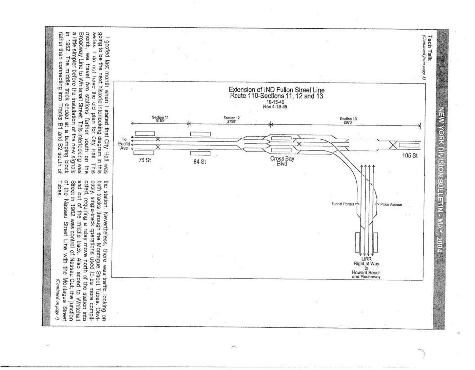
The IND Fulton St Subway was a major trunk line built to replace the elevated BMT Fulton St-Liberty Ave line. The subway was largely built directly below the elevated structure it replaced. It was initially designed as a major through route to southern Queens. Famously, the Nostrand Ave station was originally designed to only be local to speed up travel for riders coming from Queens; it was converted to an express station when ambitions cooled. Early in the planning process it was proposed that east of Broadway Junction the trunk line would split with one branch overtaking the BMT Jamaica Line at Cypress Hills station and the other overtaking the BMT Fulton St-Liberty Ave Line at Euclid Ave. The BMT Jamaica Line connection was cut but provisions for a potential connection were built into the tunnel walls.
In 1929 the IND Fulton Line had not yet opened but plans for extending it east were drawn up. The line was to connect to the BMT Fulton St-Liberty Ave Line which itself was to be extended as a 2-track elevated line east along Liberty Ave to Van Wyck Blvd. The line would weave along 105th Ave, 147th St, and on to Brinkerhoff Ave then east to Hollis Ave, terminating at Springfield Blvd. A branch would turn off at 180th St and head north to Jamaica Ave, turning west to 168th St. The BMT Jamaica Line originally ran to a terminal at 168th St but this section was demolished in the late 1970s as part of the Archer Ave Subway project.
By 1939 the IND Fulton St Line had been built and opened as far as Rockaway Ave and the eastern extension had been fleshed out. The 4-track subway would continue along Pitkin Ave to Cross Bay Blvd with a 2-track branch splitting off at Euclid Ave connecting to the elevated BMT Fulton St-Liberty Ave Line. At Cross Bay Blvd the subway would split with two tracks turning south, ascending to connect to the Rockaway Line, and the other continuing east along Linden Blvd. The Linden Blvd branch would run elevated from Rockaway Blvd to Springfield Blvd. An alternative route was proposed turning south along Merrick Blvd.
The IND Fulton St Line was extended to Euclid Ave in 1948. Tunnel provisions for a 4-track extension east were built but after the IND Rockaway Line was connected in 1956 no future extensions were proposed.
11: IND Ft Hamilton Line and Staten Island Tunnel (1920s-1939)
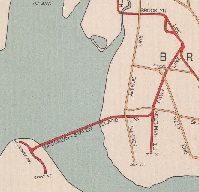
A rail tunnel between Staten Island and Brooklyn (or even Manhattan) had been proposed in the 19th century by overly ambitious railroad men but it wasn’t until the BMT 4th Ave Subway was built in the 1910s that these proposals were taken seriously. The BMT 4th Ave Trunk Line was built with 4 tracks from Atlantic Ave to 62nd St in Sunset Park. The 2 local tracks continuing south to 95th St were built on the east side of 4th Ave so that there would be space on the west side to expand the line to 4 tracks. Off the line was to be built a track connection to a Staten Island tunnel, built under 68th or 67th streets. Construction was briefly begun in Owl’s Head Park but was canceled and filled in.
The BMT 4th Ave Line had major capacity constraints due to poor track layout at DeKalb St station, forcing trains to pass at grade in front of one another. This limit made any tunnel to Staten Island a dubious proposal. The 1929 IND Second System proposal did not include any rail tunnel to Staten Island, although it did propose a highway tunnel where the Verrazzano Narrows Bridge would ultimate be built.
In 1933 the IND opened the IND South Brooklyn Line from Jay St to Church Ave (F, G trains). The 4-track subway was designed to overtake the BMT Culver Line to Coney Island, but this would not happen until 1954. Planners looked for ways to utilize the line, which had excess capacity. At the behest of south Brooklyn businessmen, a branch to Bay Ridge and Staten Island was proposed and included in the 1939 plan. The Fort Hamilton Parkway Line would branch off the IND South Brooklyn Line as it curved along Ft. Hamilton Parkway to McDonald Ave.
No concrete details were released about the line but one branch would have run to 86th St in Bay Ridge while the tunnel to Staten Island would have run along 67th St to Bay St on Staten Island. Here the line would have split with one branch heading south to Grant St in Tompkinsville and the other to Westervelt Ave and Richmond Terrace. Though not officially proposed, it is assumed that the Staten Island Railway would have at some point been connected to the subway lines.
After World War II, the city also looked at rerouting the BMT West End Line into the Ft Hamilton Parkway subway instead of building it to Staten Island. This would have opened up even more capacity on the BMT 4th Ave Lines. When Robert Moses built the Verrazzano Narrows Bridge, he made sure to design the bridge so that it could not carry trains. Since then, no serious proposal has been made to extend the subway via Brooklyn to Staten Island.
12: Flushing Line Extensions (1920s-1940s)
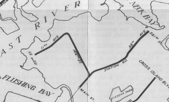
In 1917 the elevated IRT/BMT Flushing Line opened as far as 103rd St station (service was provided by both companies.) In 1925 it was extended to downtown Flushing. Residents demanded that the line be buried in a tunnel in the central business district.
Main St was not intended on being the final terminal–the line was planned to be extended east to Bayside. The subway was to come above ground west of Northern Blvd and run alongside the LIRR Port Washington Line until 39th Ave where it was to continue along the avenue to 221st St.
Between 1929 and 1939 the Bayside branch was retained but a second branch along 149th St to Whitestone and College Point was added. After World War II both extensions were quietly dropped. In the 1950s it was proposed to convert the LIRR Port Washington and Rockaway Beach Branches to subway operations via a new tunnel under the East River. The 63rd St Tunnel was eventually built but was connected to the IND Queens Blvd Line instead.
13: Long Island City-Horace Harding Line and Long Island Expressway Branch (1929-1968)
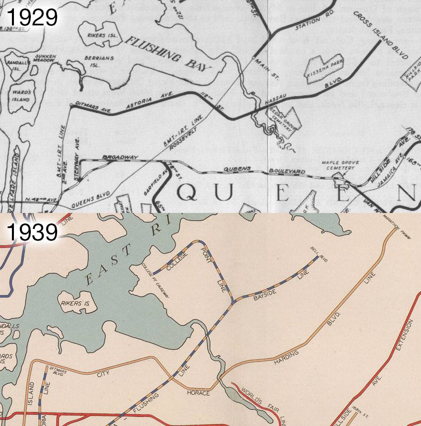
In 1929 the IRT/BMT Astoria Line (service was provided by both companies) was proposed to be extended from its terminal at Ditmars Blvd to Horace Harding Blvd, now the Long Island Expressway (LIE). The Astoria Line was built with 3 tracks between 39th Ave and Astoria Blvd stations and 2 tracks to Ditmars Blvd. The elevated extension was to be 2 tracks from 31st St to Astoria Blvd where it would expand to 4 tracks. It would run down Astoria Blvd to 114th St and turn south and then southwest to reach Horace Harding Blvd. Flushing Meadows Park was still in planning so it is not known how the line would have interacted with the park (or the subsequent World’s Fair of 1939). It would continue as 4 tracks to Parsons Blvd and then as 2 tracks to Springfield Blvd.
In 1939 the line had evolved from an elevated extension to a subway splitting off of the BMT 60th St Tunnel and running north along 21st St where it would turn down Ditmars Blvd and continue as before. Focus shifted in the 1950s from a new subway to connecting the BMT 60th St Tunnel to the IND Queens Blvd Line to provide local service to Manhattan.
Robert Moses built the LIE by expanding Horace Harding Blvd while purposely leaving no facilities for mass transit. As part of the 1968 Program for Action it was proposed to rebuild the LIE with either a rail line down the median or along the frontage roads. The LIE Line would branch off the IND Queens Blvd Line at Woodhaven Blvd station, which was to be expanded from a local to an express station. The branch was designed to access both the local and express tracks. It would feature 2 tracks from Queens Blvd to Kissena Blvd with a 3rd layup track at the Main St station. A future extension east to Springfield Blvd was envisioned.
14: Midtown-Queens Tunnel and the Queens Super-express (1939-1970s)
The first subways from Manhattan to Queens opened the vast farms of the borough to residential development. As part of its original system the IND built a new tunnel under the East River to 53rd St in Manhattan for express trains. Local trains would run along the IND Crosstown Line (G train) to Brooklyn but not enter Manhattan. Since these lines had not yet opened by 1929 no new rail tunnels were proposed for the first Second System plan.
By 1939 it was evident that an additional tunnel for local trains was needed to Manhattan. The first proposed tunnel was to run from the IND 6th Ave Line at 53rd St up through Central Park to 79th St then under the East River to Broadway in Astoria. The 2-track tunnel would then connect to the IND Queens Blvd Line local tracks at Steinway St. The existing Steinway St station would be converted to a terminal for the IND Crosstown Line. An alternative proposal connected the new tunnel to the BMT Broadway Line at 7th Ave and 59th St.
The growth of Queens accelerated after World War II and a new tunnel became attached to the 2nd Ave Subway. A branch of the IND 6th Ave Line would turn down 57th or 61st streets and connect to the 2nd Ave trunk line. At 79th St a branch would turn to Queens. Branches in Queens were proposed to run along the LIRR Port Washington and Rockaway Beach Branches, or even a separate line along Northern Blvd to Main St in Flushing, then down Kissena Blvd to the LIE.
Geological tests found that the best location for a new tunnel was around 64th St. The Rockefeller University Medical Center objected to a subway, which they claimed would negatively impact their equipment. The tunnel was moved to 63rd St and was designed to connect the BMT Broadway and IND 6th Ave Lines to the west with the proposed 2nd Ave Subway and Queens. The tunnel was to feature two levels, the top for subway trains and bottom for LIRR trains heading to Grand Central Terminal.
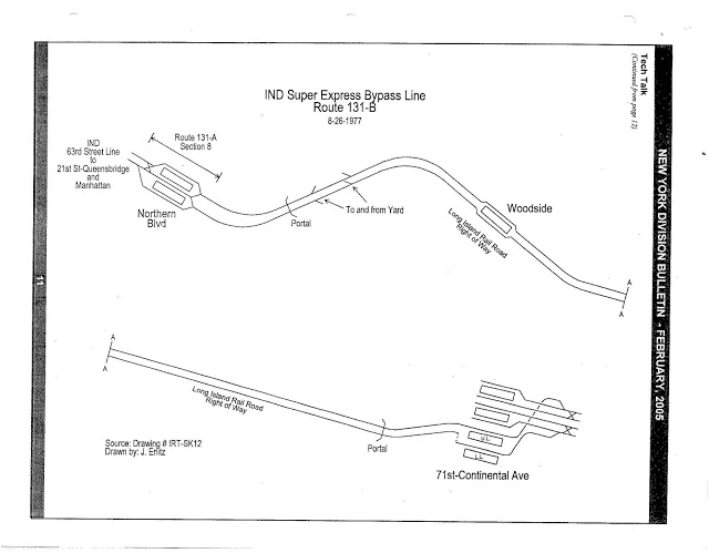
By 1968 the tunnel was under construction, but the eastern end had not yet been defined. It was decided to reuse the LIRR Rockaway Beach Branch trackways which ran along the Main Line to 63rd Dr in Rego Park. From here the tracks would dive underground and connect to the IND Queens Blvd Line as a super-express line which would reroute express trains from Jamaica around the congested IND Queens Blvd Line. The line was to be further connected to the proposed Archer Ave Subway in central Jamaica.
The financial decline of the city halted work on the 63rd St Tunnel and Archer Ave Subways. Funds were found to keep construction going, but the connecting super-express tracks were cut. Archer Ave was eventually opened in 1988 and the 63rd St Tunnel was opened in 1989, but not connected to the IND Queens Blvd Line at Northern Blvd until 2001.
15: Morningside Line and Bronx Super-express (1939-1960s)
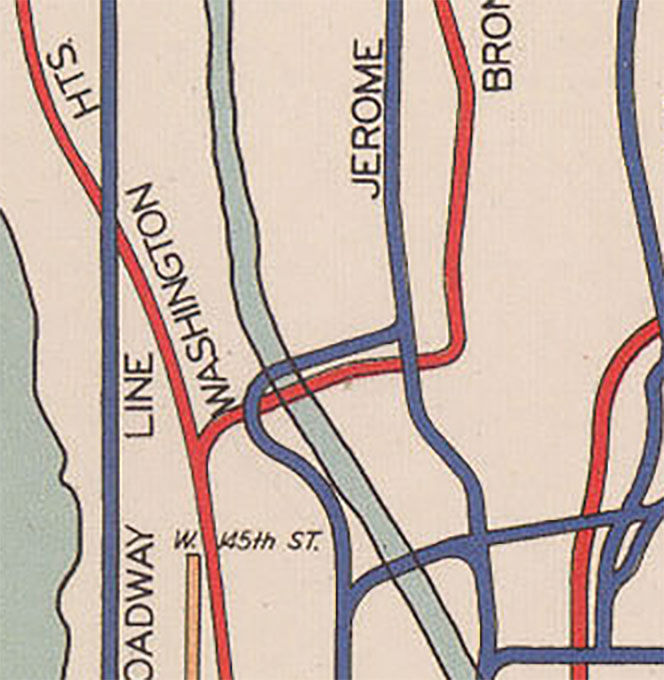
Before the city decided to build the IND 8th Ave Line, the BMT had built its Broadway Line for a 4-track extension from 7th Ave and 59th St north along Central Park West. The IND made such an extension unnecessary, but by 1939 there was enough traffic coming from Washington Heights and the Bronx that planners decided to add another set of tracks. At 145th St the 4-track 8th Ave line split into a 4-track branch to Washington Heights and a 3-track line to the Grand Concourse. Both branches were limited in capacity.
The Morningside Line was a 2-track line designed to split off either the BMT Broadway Line or IND 6th Ave Line and run parallel along Central Park West to 110th St where it would swing west and run along Morningside Ave and then Convent Ave to 145th St. No further connections to either the IND 8th Ave Line or IND Concourse Line was discussed but it could have easily been connected to either one based on demand.
In the late 1950s and early 1960s the city was looking for cheaper alternatives to building the 2nd Ave Subway, and proposed a similar route to the Bronx. The Bronx super-express was to connect both the BMT Broadway Line and IND 6th Ave Lines to a new 2-track tunnel north under the east side of Central Park. At 110th St the line would move over to Madison Ave to the Harlem River. Two branches were proposed: the first north to connect to the IND Concourse Line, and the other to head east and connect to the IRT Pelham Line. A branch to Queens via 79th St was also proposed. Upper East Side residents demanded that any new tunnel be built along 2nd Ave and the plan was dropped.
16: IND Concourse Line Extension (1929-1970s)
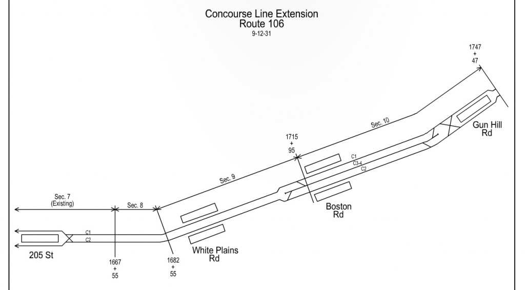
The IND Concourse Line was built from 145th St to 205th St in Norwood, the Bronx, but was always designed to continue further. After Bedford Park Blvd station, the line makes a 90 degree turn east. The tunnel past 205th St station is built right up to Webster Ave and was intended to be extended on a two-level bridge above Bronx Park to Burke Ave; The upper level would have been a roadway. In 1929 the extension was planned to run as a 2-track subway east under Burke Ave to Boston Post Road, then along the Post Road to Baychester Ave. A connection to the IND 2nd Ave Morris Park-Wilson Ave Line was proposed as well.
By 1939 the New York, Westchester & Boston Railroad had gone bankrupt and the city was in talks to purchase the line for integration into the subway. Some called for the IND Concourse Line to be extended along the ROW of the railroad but ultimately the line was connected to the IRT network at 180th St. Plans for an altered IND Concourse Line extension which turned from Burke Ave down Gun Hill Rd existed for a few more years, but once the IRT Dyre Ave Line opened the need for such an extension was gone. As part of the 1968 Plan for Action a shorter extension from 205th St to White Plains Rd was proposed.
17: IND Hillside Ave Extension (1929-1939)
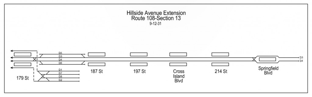
The IND Hillside Ave Line opened in 1937 as an extension of the IND Queens Blvd Line. Initially the line was only built to 169th St but was planned to run as far as Springfield Blvd. World War II delayed further extension but after the war the line was extended only one station to 179th St. East of 179th St a large underground yard was built which featured 8 layup tracks. A future extension east to Springfield Blvd could therefore be built off of either the local or express tracks and not interrupt trains terminating at 179th St. In 1939 it was proposed to continue any extension east of Springfield Blvd to Little Neck Parkway, but after 179th St was opened no further extensions were planned.
18: BMT Canarsie Line Extension (1968-Present)
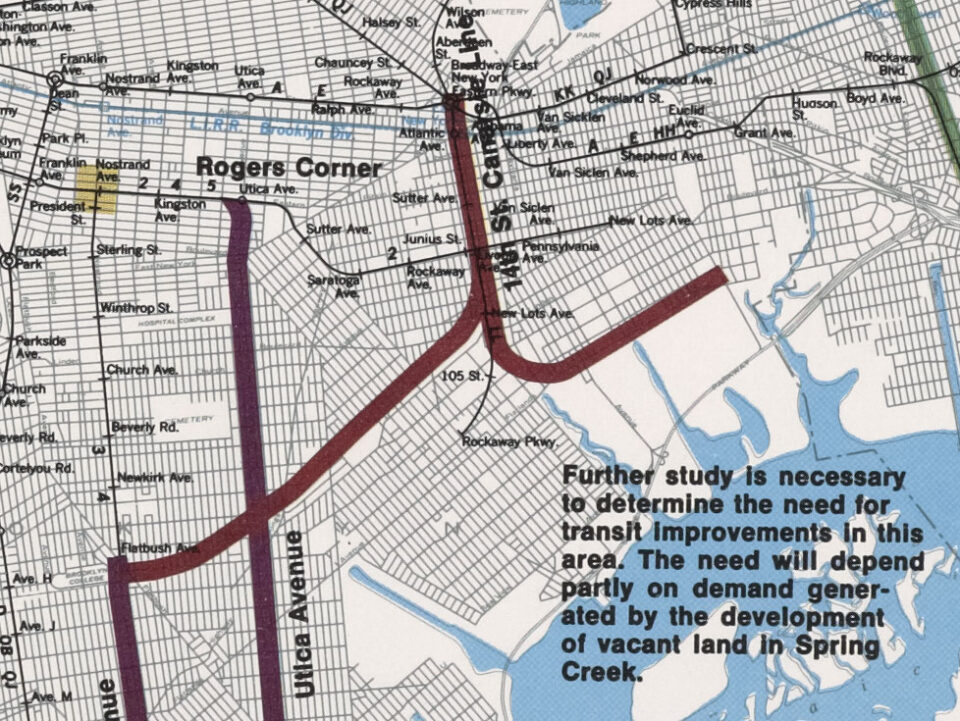
At the end of the 1960s the City of New York proposed an enormous redevelopment scheme on the edge of Jamaica Bay in New Lots, Brooklyn. By filling in the marshlands south of Flatlands Ave the city could build entire new neighborhoods. The neighborhoods were to be linked to the city via the proposed Cross Brooklyn Expressway (unbuilt) and an extension of the subway. At first the city looked at extending the IRT New Lots Line (3,4) from New Lots Ave to Flatlands Ave but settled on rerouting the BMT Canarsie Line (L train).
From Wilson Ave to New Lots Ave, the Canarsie Line parallels the New York Connecting Railroad and LIRR Bay Ridge Branch. South of Bushwick Ave the line runs elevated over the depressed railroad right-of-way. The plan proposed moving the Canarsie Line into the existing railroad tunnel below Broadway Junction and along the depressed right-of-way. After Livonia Ave the line would split into two branches: one would follow Flatlands Ave east and terminate around Linden Blvd and Conduit Blvd, the second would swing southwest along the LIRR Bay Ridge Branch, or in the median of the Cross Brooklyn Expressway, to an initial terminal at Nostrand and Flatbush Aves. A potential extension west to New Utrecht Ave was also suggested.
A combination of factors ended the project. The federal government made huge cuts to urban redevelopment plans and highway spending, and the financial collapse of the city meant that local funds could not be used either. The large redevelopment was scaled back and the Cross Brooklyn Expressway canceled. Starrett City came close to the scale of the proposed redevelopment and the Gateway Center was eventually built on landfill at much smaller scale. But both remain far from the subway.
This makes my nerd heart so happy, I’ve been waiting for years for a full breakdown of how the Second System would look like.
Yeah, I’m really digging it, although it can be a little hard to keep track of which plan is what.
How did you draw the map? I’ve been working on a map for some time now, I basically screenshot the satellite view of the city on Google Earth (yeah, I started like 7 years ago), portion by portion and then combining them to make a base. Then drawing lines on top in Inkscape.
That’s basically how I do it. I start with a Google Maps or OpenStreetMap base tho.
amazing research & insights – thank you
Wait, there’s still some proposals missing.
1. 34th Street Crosstown Line from 12th Avenue to 1st Avenue
2. Extension of the IRT New Lots Line from New Lots Avenue to Lefferts
Boulevard.
3. A line from Astoria, Queens, across the East River and via 125th Street
4. A line running along Manhattan’s West Side, stretching from the edge of the city at Yonkers to 14th Street. It would be a two-track line south to Dyckman Street, a three-track line to 162nd Street, and then-on it would be a four-track line. The line would have two southern branches that would diverge at 14th Street. A connection to the BMT Canarsie Line would use a pair of the tracks, while the other pair would go to Atlantic Avenue and Hicks Street in Brooklyn through an East River tunnel. Then it would turn down to Red Hook. There would also be a loop at Battery Park. Another branch would be built; it would consist of two tracks, and would go between 162nd Street and 190th Street via Amsterdam Avenue.
5. A line branching off of the IND Crosstown Line running via Franklin Avenue connecting with the BMT Brighton Line. This would have replaced the BMT Franklin Avenue Line.
6. A tunnel at 76th Street that would connect to the Second Avenue Line that would run under the East River and connect with the existing Long Island Rail Road main line.
7. Extension of the 1 train into Red Hook, Brooklyn.
Oh, and you forgot the Triboro RX
#2 is in there as an alternative to the Canarsie Line extension. #6 was replaced by the Queens Super-express but I could include it as an alternative. #1 I think that was more of a people mover system and not necessarily a heavy rail subway. I’ll look into that. None of the rest were official proposals as part of the IND Second System or Program for Action.
Edit: the new crosstown line is described as a “crosstown link” with no other description given. Unless I find something more concrete I’m going to leave it out.
I want to say thank you so much for your work here. You’ve saved me much time in researching for a novel I’m writing about NY Transit. I’m also working on a railway simulation.
Well done! Thank you!