
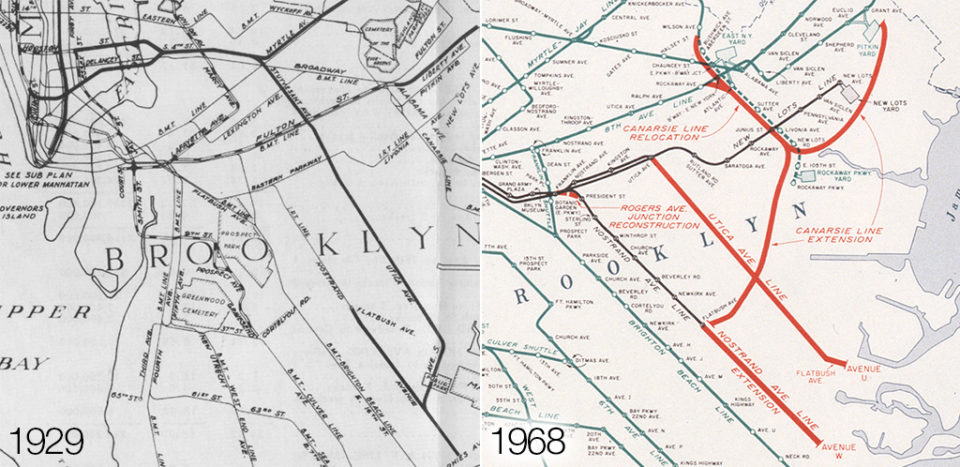
The Utica Ave Subway has always played second fiddle to its more well known and well documented younger sibling 2nd Ave. But Utica predates 2nd Ave by at least a decade. The first instance I can find of a proposal for Utica comes from a NY Times article in 1913 where residents were debating the best route. When the IRT built the Eastern Parkway Line between 1915 and 1918 they built into it a provision for a future branch down Utica Ave (the IRT, in fact, built its entire Brooklyn section with many provisions for future expansion that either never happened or ended up being built by a competing company). As part of the NYS Public Service Commission report in 1912 on new lines the Commission recommended a 4 track 14th St Subway with branches through Williamsburg. Although not in the official report, soon after it was proposed to connect 14th St to Utica Ave. This would be the beginning of the IND plan which would ultimately propose extending a branch of the 6th Ave Subway through Williamsburg and down Utica Ave.
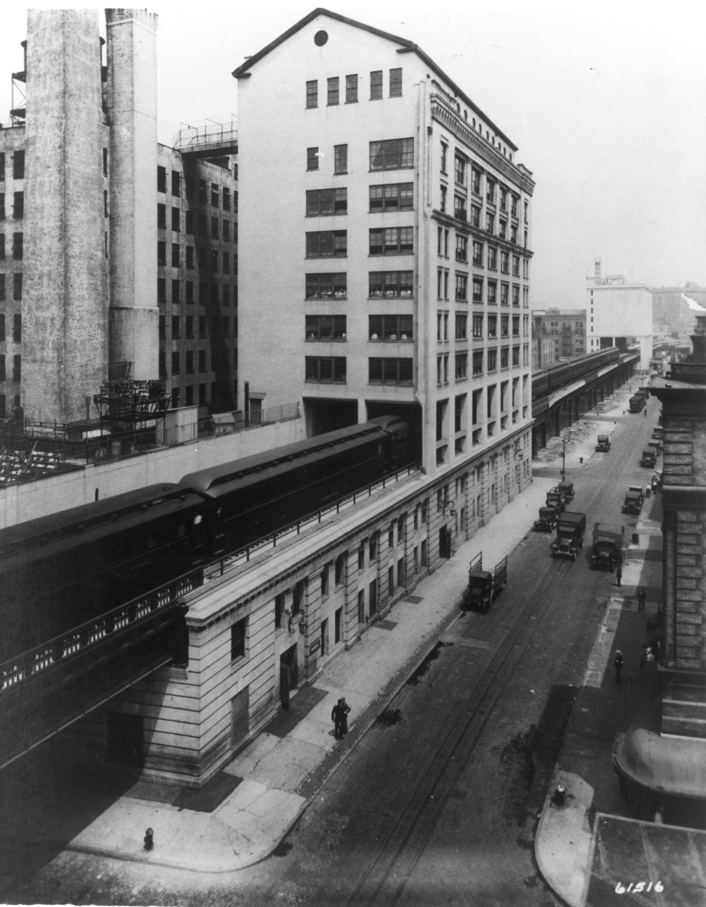
When the IND built their lines they did so with room for expansion and most of the provisions and abandoned sections that did get built had something to do with Utica Ave. The 2nd Ave station (F line) was built with express tracks pointed towards Brooklyn (the 6th Ave express trains would have made up the bulk of the Utica Ave Line), at the Broadway G station there is the shell of the never built South 4th St station which was to serve Utica Ave trains, and at Utica Ave station on the Fulton St Line (A/C lines) there was on the upper level a shell for a 4 track station for Utica Ave trains.
With these and the IRT provisions in place Utica Ave was always so tantalizingly close. But after World War II priority shifted to rehabilitating the existing system and even through Utica Ave would be featured in many of the post-War expansion plans there always seemed to be other projects that got chosen first. Even today Utica makes too much sense. It’s a dense, transit dependent corridor with a recently opened and popular Select Bus Service line and the Utica Ave stations on the 3/4 and A/C have some of the highest ridership on their respective lines. In 2015 Mayor Bill de Blasio even proposed bringing the line back and supposedly the MTA has been studying the plan since. In fact I am writing this today because I want to get ahead of whatever the official plan might state; I have very little faith in MTA planners and I feel that anything they release will be overly designed in a way so that it’s D.O.A.
From a strictly design point of view there are two main reasons that Utica has never gotten off the drawing boards. The first is that much of the line, as proposed by both IRT and IND engineers, was to be an elevated line. The New Lots branch of the IRT ascends to the surface right after it leaves Eastern Parkway (due very much to the terrain) and it would make sense that the IRT would have the Utica Line do the same. In IND reports it was proposed to have the line remain as a subway until Ave J where it would ascend to the surface and run elevated, originally to Sheepshead Bay, then later a more simplified route down Flatbush Ave to Floyd Bennett Field. While cost is an obvious reason for building an elevated over a subway there are also geological concerns in this area as the land through which Utica Ave runs has a very high water table and very sandy soil. Building a subway in these conditions means having to deal with tunnel flooding more so than normal and flooding means corrosion. Despite this residents of southern and southeastern Brooklyn would continually oppose any plan that involved elevated trains (even extensions of the Nostrand Ave Line as an elevated were blocked). Secondly is that the IND plan, like most of their plans, was wildly over designed and would require extra miles of subway from Eastern Parkway to the Lower East Side as well as a much wider 4 track trunk line instead of the IRT’s proposed 2/3 track line (much like the New Lots branch the line would have been built with 2 tracks and space for a third to be added later).
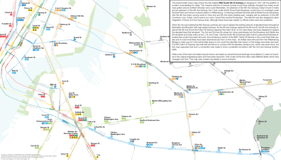
There is another part of the IND plan which, as far as I can tell, no one has figured out or brought up yet. One of the main reasons that the City wanted to build the IND was to replace the existing elevated lines which were old, slow, and unpopular as they cast streets in shadow and soot. The 8th Ave Subway was designed to replace the 9th Ave El, the 6th Ave and 2nd Ave Subways to replace elevateds running above their avenues. In the Bronx the Grand Concourse Subway was designed to at least compete with the Jerome Ave elevated if not eventually replace it and in Brooklyn the Fulton St Subway was built to replace the Fulton El out to Queens with provisions built to allow a connection with the Jamaica Ave elevated. It stands to reason, then, that the massive South 4th Subway with branches to Utica Ave and along Myrtle Ave was designed to replace the Broadway and Myrtle Ave Els as well. Taking this one step further this also supposes that, as the Worth St Line was to serve a similar catchment area as the BMT Centre Street Line (J train) that the new subways through the Lower East Side would replace the Centre St Line, thus leaving it up for abandonment (if this seems too preposterous keep in mind that half of this line is already, for all intents and purposes, abandoned).
I often speak with other fantasy transit designers about Utica and the IND plan seems to be the favorite and for good reason. “Make no little plans”, Daniel Burnham is purported to have said, “they have no magic to stir men’s blood”. Drawing fantasy lines on paper is far more fun when you have unlimited possibilities but if we are planning out a project today there are some real world considerations that come first. In my futureNYCSubway plans over the years I’ve always included Utica Ave in one form or another but one of the reasons I drew my NYC Subway Track Map was so I could see what I was really dealing with so we know what is really possible.
Looking at a modern take on IND plan, since the Chrystie St Connection rerouted the 6th Ave express trains over the Manhattan Bridge and the extra local service to Williamsburg, there is no extra capacity along 6th Ave to connect with the new line. This leaves the possibility of resurrecting the Worth St Line, a branch off the 8th Ave local that would split south of Canal St and head east via Worth St and East Broadway. The 2 track Worth St Line would require a 3.15 mile tunnel from Tribeca to Williamsburg. From the South 4th St station to Eastern Parkway is another 3 miles which would parallel the existing J/M/Z trains.
Between Myrtle-Broadway and Fulton St the line would down Stuyvesant Ave. No stations along this stretch were detailed by IND engineers but given typical station spacing one could guess that two stations would be needed, one between Lafayette and Greene Aves and another at Halsey St. The upper level at Utica Ave station on the Fulton Line would be used but only half of the existing structure would be needed since the modern line would be two tracks. Between Fulton St and Eastern Parkway the crest of the ridge which runs along Long Island rises 52 feet. On the opposite side, from Eastern Parkway to Empire Blvd, the slope descends 66 feet. The ascending tunnel grade would be about 1.4% and the descending 3.3%, both reasonable. A new station would therefore have to be built below the existing 3/4 Utica Ave station before continuing south.
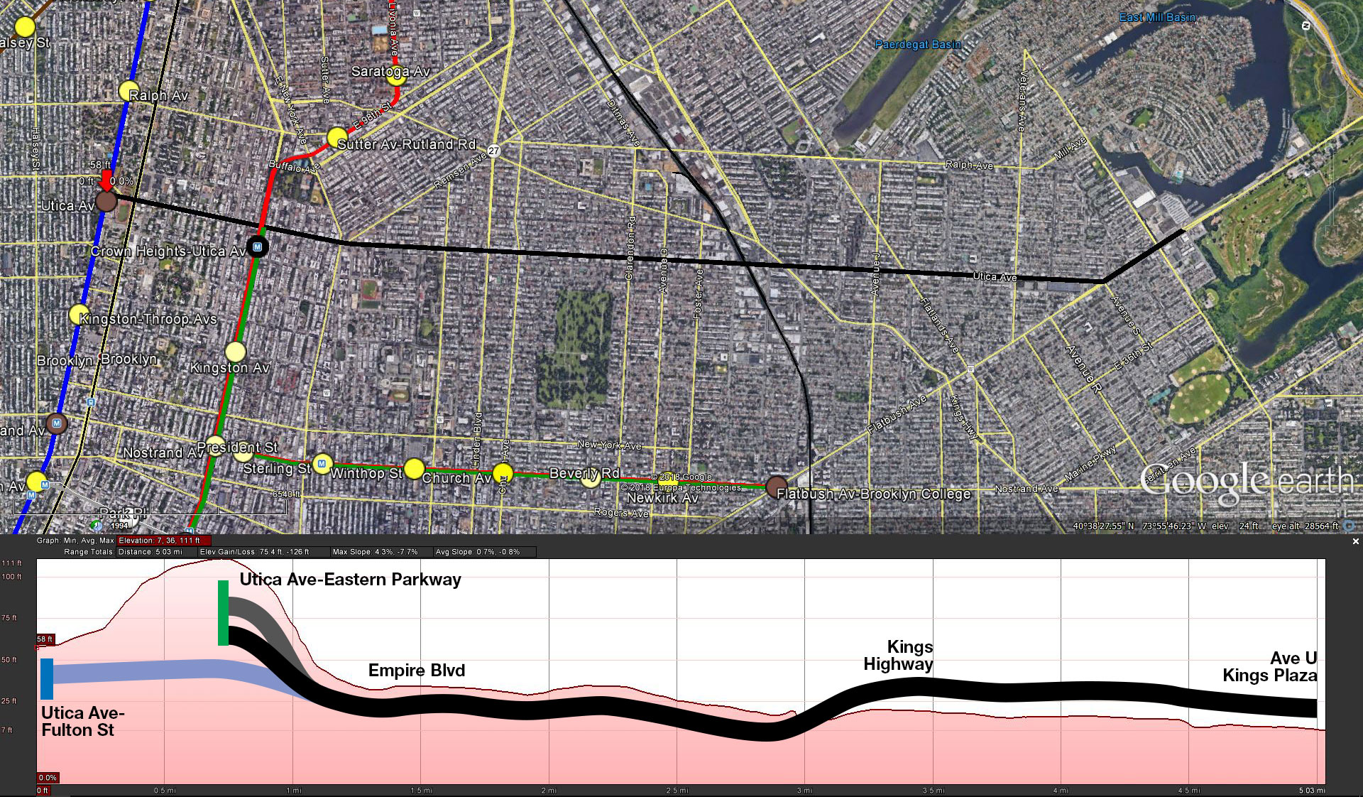
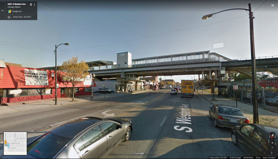
Now we reach Utica Ave. The subway itself would run straight down Utica Ave with potential stations at Empire Blvd, Linden Blvd-Church Ave and Clarendon Rd. Past Clarendon Rd the line would split with two tracks peeling east to a new yard facility built along the LIRR Bay Ridge line (requiring land taking). South of Kings Highway, due to the aforementioned geological issues, the line would have to be elevated. But what I’m proposing, and what I’m sure no City plan would dare propose, is that the line not run above the center of the avenue such as existing elevated but rather along private land on the west side of the street. The only elevated line that the IND ever built was the Culver Viaduct between Carroll St and 4th Ave-9th Sts and this was done in a similar way. The Culver Viaduct is at maximum 90 feet wide requiring it take up half the block (Brooklyn blocks like these are 200 feet wide). A 2 track line would only require half the space, 45 feet and with 100ft lots this leaves room for an ingenious workaround. The elevated structure would be built in such a way that future buildings would be built around and above the line. Going further the stations could even be built by private developers who would get a height bonus for building the station. The MTA would then lease the land as a way to bring in continued revenue and the new development would help pay for the construction.
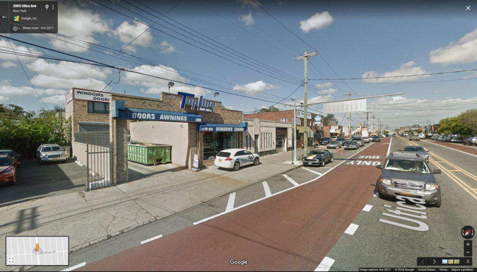
Lest I bring on comparisons to Robert Moses I would like to point out that on the western side of Utica Ave, from the Bay Ridge Line to Flatbush Ave, there are exactly 9 residential buildings. Everything else is a single or double story commercial or light industrial building, parking lot, and one school. The 9 residences, all located at Avenue M can all be replaced (and with new development replaced 100 times over) while the commercial and industrial buildings would all be replaced by buildings of much higher density and better uses than chop shops. The school, at Avenue J can very easily be replaced using the existing parking lot across the street. Between Avenue O and Fillmore St is an MTA bus maintenance facility which can be rebuilt to have a small yard on the roof. South of Kings Highway would be stations at Flatlands Ave, Ave N and after the line turns down Flatbush Ave, at Ave U-Kings Plaza. This final station is worth considering because even though half the catchment area is parkland and the Mill Basin canal the station would serve the popular Kings Plaza Mall and there is space for a modern bus terminal for better service around southeastern Brooklyn and to the Rockaways. Unlike the Utica Ave stretch, the Flatbush Ave structure would run along the center of the street on a modern concrete viaduct (similar to what the AirTrain uses long Van Wyck Expressway). Flatbush Ave is extra wide along this section and the median would be used to create a safer traffic pattern.
There seems to me to be two sections of this plan: the Worth St-South 4th-Stuyvesant Ave section and the Utica Ave section. Given the history of cost overruns and delays that the MTA is infamous for it seems foolish to build a project which requires so many moving parts even before the most important section can be built. Furthermore, the neighborhoods in northern Brooklyn through which the first part of the line would run are already served by existing subways. Since we are only building Utica and not the larger network designed to replace the elevated that means that the subway would be competing with the existing trains for riders and based on ridership statistics the stations along the route aren’t exactly bursting at the seams: in 2015 annual ridership numbers
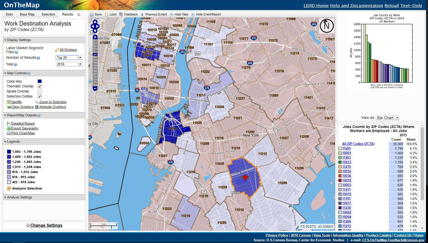
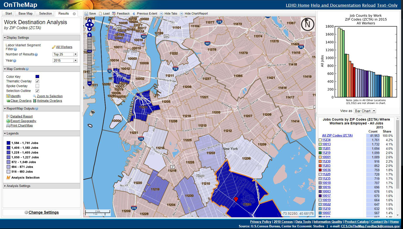
- Hewes St: 981,379
- Lorimer St: 1,614,154
- Flushing Av: 2,991,074
- Myrtle Av: 3,687,468
While those numbers are nothing to scoff at, especially as they have seen over 10% increases in ridership over the last decade, the E train at Jamaica-Parsons sees ridership of over 12 million annually. The transit desert is along Utica Ave south of Eastern Parkway. Looking at Census data based on commuting patterns of riders coming from the two zip codes along Utica Ave the primary destination for most riders is downtown Brooklyn with Midtown West second. This would suggest that even if the full line was to be built most riders would be transferring to trunk lines headed to downtown rather staying on to midtown via Williamsburg. This leads me to propose that the first part of the plan to be built is the Utica Ave stretch from Eastern Parkway to Kings Plaza connecting to the IRT Eastern Parkway Line but with provisions for a future extension north (all tunnels would be built to the larger B division specs).
The IRT built their Utica Ave station west of Utica Ave with turnouts in the track walls so that a branch could split. The bi-level station means that the branch would have a simpler time merging with the trunk. What’s needed for this to work, however, is the rebuilding of the Rogers Junction, the junction of the trunk and the Nostrand Ave Line at Franklin Ave. The junction is built awkwardly where the tunnels are twisting in such a way to become bi-level. The current switch layout requires that local trains merge directly in front of express trains causing delays and capacity constrains. The MTA studied [PDF] rebuilding this junction in 2009 and came up with two plans. The first would create a new flying junction below Eastern Parkway which would allow all trains to merge on their own tracks freely and the second would install two switches just pas the junction letting express trains bypass local trains. The first plan offers the highest operational flexibility and allows a continuation of both local and express trains to access Nostrand Ave but would cost close to $1 billion and require extensive excavation. The second plan would be far cheaper but would require that only local trains have access to Nostrand Ave while the express trains would split past the junction so that half would continue as locals and the other would run express.
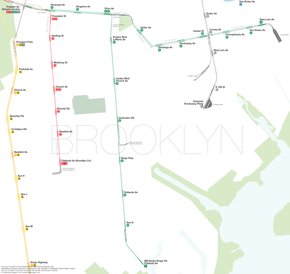
Knowing the reality of MTA construction I would argue that the second plan is the preferable option. With it both 2/3 trains would only go to Brooklyn College while 5 trains would serve the local stations, Nostrand Ave, Kingston Ave, and Utica Ave before turning south to Kings Plaza, while 4 trains would stay express to Utica Ave and take over service to New Lots. This configuration would have other benefits as the riders who are now coming from furthest away have default express trips while the 7th Ave Express-Eastern Parkway Local 2/3 trains can now have more even headways, reducing delays. An additional part of the project would be to create a better terminal at Flatbush Ave-Brooklyn College. While there are arguments to be made for extending the Nostrand Ave Line south I would argue that with the addition of Utica Ave that demand would be reduced as riders coming from the east or southeast would take Utica over a bus to Nostrand. Still, the terminal must be fixed so what is required is a short tunnel south that would allow a terminal yard of 4 tracks be built. This would boost capacity and turn around time on the entire 7th Ave express line.
There is a very good argument to be made that building the Worth St-Williamsburg section would alleviate traffic on the L train and serve a growing jobs center around Hudson Sq in lower Manhattan. But this does not deal with the immediate needs of those that live along Utica Ave. Building an extension of the IRT could be opened long before the section through northern Brooklyn and would have immediate benefits by serving more riders with direct service rather than requiring transferring. Building an elevated line designed to integrate into the built landscape rather than dominate it, while not new, is novel and one that will need time for the public to come round to. Many transit activists I talk to refuse any plan which would take a single building but this is unrealistic in any city. Even 2nd Ave had to take a few buildings for ventilation plants. But what this plan does is allow for a new and better city to grow around the line rather than be divided by it. I know this is something that the City won’t consider if they ever release their Utica Ave plan which is why I want to start the discussion now. No doubt they will propose some deep bore subway with expensive stations that will take a decade or more to build. Alon Levy did a back-of-the-napkin estimate of how much a mostly elevated line would cost and found it a better cost per rider than even 2nd Ave. For future expansion of the system we need to be open to thinking outside the box.
mind=the same
why did you completely destroy the jamaica line, cant we just make a 3/4 line extension? much cheaper and fits the mta’s little goes a long way attitude
Did you even read the post?
The MTA has only been making these small extensions, the last major one (affected more than 3 lines) was in 1967-1968, which changed the BB, T, TT, D, F, JJ, M, MM, and the QT, and added the QJ, B, and KK. So we really have to make the most out of the small extensions for now.
no, i only looked at pictures, ill look at post now LOL
I do like the general arc of this post, although there is one bit I find a bit questionable;
> Looking at a modern take on IND plan, since the Chrystie St Connection rerouted the 6th Ave express trains over the Manhattan Bridge and the extra local service to Williamsburg, there is no extra capacity along 6th Ave to connect with the new line. This leaves the possibility of resurrecting the Worth St Line, a branch off the 8th Ave local that would split south of Canal St and head east via Worth St and East Broadway. The 2 track Worth St Line would require a 3.15 mile tunnel from Tribeca to Williamsburg. From the South 4th St station to Eastern Parkway is another 3 miles which would parallel the existing J/M/Z trains.
There is actually going to be a place to connect that will be much easier; the Second Avenue Subway’s current iteration is supposed to have lower level storage tracks from 21st to 9th Sts. Given that the L is now the busier of the two lines and needs relief, badly, it would be much more sensible IMO to go east across E 7 St to stations at Tompkins Square Park, Metropolitan/Bedford, Hope/Union (G) (L), Humboldt/Montrose (L), and Myrtle Av (J)(M)(Z), to provide a faster alternative to the L. I don’t really think there’s much value in duplicating Broadway services just because S 4 St exists.
But that still requires 2nd Ave to be built first. The point is that focusing on just the Utica Ave section alone could make this project shovel ready while 2nd Ave Phase 3 is still a pipe dream. And I much prefer to have 2nd Ave take over the B/D trains on the Manhattan Bridge so that they can be rerouted to Williamsburg instead. That gives you much more cacapity to work with than just the 10 tph you be stuck with via your plan (assuming you mean to have it be the Queens Blvd branch of 2nd Ave)
I never said I disagreed with staging it so that Utica is first built. I just disagree with a Worth St subway being the best choice, since unlike the Second Avenue tracks, the Eighth Av local does have capacity constraints in the railroad north direction (both CPW local and 53 St have two services each, which is about as much as you want to push on a pair of tracks before service gets too unreliable).
I would have to strongly object to abandoning Phase IV; that still leaves the entire SAS and Sixth Av LES stations without a direct connection to downtown (and thus fails the objective of relieving the Lex), leaves Water St underserved despite heavy employment density, and subjects SAS to the whims of the DeKalb interlocking. Better to have SAS – Williamsburg via the 9th St storage tracks and SAS – Fulton local as the obvious trunk line that needs new capacity.
Where do you get 10TPH from? The Queens Boulevard Express turns out 15 TPH each on its two services, and if anything DeKalb is the major limitation here; at least with Sixth Avenue it’s not the biggest deal since the merges on both ends of CPW also limit capacity.
I agree using Worth has disadvantages. Part of why I wanted to write this post was to point out the downsides to going with an IND style Utica Ave over IRT. With IRT you are constrained slightly but smoothing out the Rogers Junction gives you more to work with and if Utica proves more popular than New Lots then you could run some special 4 trains down there at rush hour. Far simpler with more capacity.
I outlined my plans for 2nd Ave in a previous post but one thing I only mentioned in passion was how Phase 4 could be achieved cheaper if it was connected to Nassau St after Chatham Sq (as in, 2nd Ave would not connect to Centre St by Bowery by to Nassau St by Chambers). Building it to Water St requires all new infrastructure there and a new East River tunnel (which isn’t needed) and with Nassau St located closer to the heart of the Financial District and with better transfer options (that Water St would not be able to provide) it seems obvious that it’s a better routing. Then you can continue trains on into Brooklyn. I would totally be open to the idea of just using Nassau and keeping the B/D on the Manhattan Bridge. But the question is what is more dire, commuters coming from Wall St (with their many different subway options) or those coming from Williamsburg (with the congested L)? I chose to believe that rerouting the B/D to Williamsburg opens up far more possibilities. But that’s how I see it.
Adding another train to Queens Blvd is a problem. Even with CBTC you are limited to about 10-12 tph on each of the (now) three local services (it most definitely does not turn out 15tph on both local service now, closer to 15tph for both combined). So that means that you are going to build a trunk line that is supposed to take pressure off the L that can only run 10-12tph. Given the upfront costs of building it that seems like a waste (yes, 2nd Ave only hits that with the Q but it is at least designed to add the T later on). Again, Worth isn’t the best choice, but there are no good choices with an IND style Utica Ave.
Not bad. I’m more in support of an IRT Utica Avenue subway and now you made a Rogers Junction plan clear. Thank you. Though I’d suggest building a peak direction track on Utica Similar to the 6 and 7 lines. Also (while a 4 track yard is good for Relay past Brooklyn College.) Why is it diverging to face the Bay Ridge Branch? Last but not least, are the 2 and 3 doing skip stop?
Oh shit I forgot I was playing with skip-stop. Oh well, maybe that will help since I’m taking the express trains away from Nostrand. I was talking with someone at the MTA and they mentioned that the planners were playing with the idea of building the relay along side the Bay Ridge because there was more space/cheaper than extending a tunnel south. It’s not a great idea but I was going off what I heard. I don’t really see the need for a peak direction track this far out. The 5 is already going express and with further station spacing you would still have good run times. Kings Plaza isn’t downtown Flushing so you aren’t going to have that demand. Even the New Lots branch doesn’t have a third track and you could argue it needs one more than this.
When looking at your plans for Utica Avenue, you seem to only put emphasize on what the area is like now and not in the future. Remember any from of transit is only used when planning for the future such as the L train renovations and Clark tunnel reconstruction. The station listings are extremely far apart to where it barely serves any local communities on the route. If we are going to think outside the box, we ust consider the people who will be having trains running through their buildings while a stop is not even placed within walking distance. Especially for a line such as the 5 that lacks walking distance stations in comparison to the Nostrand Avenue line. Its an extremely clever plan that I and many other would have never of came up with but there are some wholes that are worth being built up. Excellent nonetheless.
You bring up a good point. The station spacing was done to keep costs down. However, if such a public-private partnership could be established and developers enlisted to build the stations then a couple more could be added.
Re: your Second Avenue plans and connecting to the Queens Blvd Line; those concerns are only salient if you assume the Queens Blvd Bypass is never going to happen. Queens Blvd is one of the busiest trunk lines in the city, so it’s definitely a second on the priority list, and even with East Side Access the MTA has set aside room to build the connecting tracks for the Bypass. So there’s a source of northern capacity right there.
So your service pattern would look something like this, which is perfectly doable
north of 63rd – Q, T to Fulton local, 15TPH each
south of 63rd – V from Bypass to Utica via Williamsburg, 15 TPH each
Williamsburg in comparison to a Bypass is a much lower priority, since the L is not operating anywhere near signalling capacity; upgrading the power supply gives you a bump from 21TPH to 26TPH, nearly a 25% increase in service, and building tail tracks and appropriate terminals also increases that number. I also don’t believe in using provisions for the sake of using provisions; S 4 St (the actual street parallel to Broadway) was never fully completed, so building a subway using that old path would be wildly expensive.
I highly disagree with connecting SAS to Nassau. As you point out, the area already has subway service. It won’t really be providing new services, since you’re just substituting services that already exist. And it’s not a good alternative to the Lex, for the East Side, since the Lex is both more direct and has express trains.
Connecting the currently planned SAS to Fulton’s local tracks involves building zero junctions and minimal interlining. On the other hand, your SAS plans involve building at least two complicated junctions to active tracks (including one under the East River) and lots of reliability-tanking interlining.
I will say that the Utica stop spacing is fine; it’s not any wider than the Queens Boulevard local and it stops at every intersecting street with a frequent bus connection. In fact, it makes pretty much every stop that the current B46SBS makes except for Winthrop, which IMO is not really deserving of a stop.
Great idea. Youre forgetting one thing though when you switched the 3 and 5 terminals. The 5 train doesn’t run in Brooklyn on late nights and weekends. 3 trains dont go to Brooklyn late nights. So on late nights obviously the 2/4 would run local. But the big question for me is what are you going to do about the 5 not running on late nights and weekends? Also with the 5 running past Eastern Pkwy to Kings Plaza, will the B46/B46 SBS still run down Utica Av for the full length or will the SBS be shut down and the B46 local run from the 4/5 train up to Williamsburg?
Also, that wasnt a smart move, moving the 3 and 5 so that all local trains past Franklin Av are linked up together, and all express trains past Franklin Av are linked until Utica, except one’s local and the other’s still express.Most passangers at Flatbush Av( I should know, this is part of my daily commute)
want to either go to Midtown West or Midtown East. Same with Crown Heights-Utica Av. Passangers want a train for the East and West Sides.By switching the 3 and 5 you’re forcing passangers to make a crossover at Franklin when they could easily just have a one seat ride from Utica or Flatbush Av. I think I can solve that problem and still have a train servicing East NY&Brownsville, Mill Basin, and Flatbush/East Flatbush. Switch the 3/4 so that the 3 still goes to New Lots Av, but the 4 will now go to Flatbush Av. Now we know late nights the 3/5 dont run in Brooklyn. and weekends the 5 doesn’t go to Brooklyn. Late nights/weekends the 4 will go to Kings Plaza. Late nights a shuttle will run from Franklin Av to New Lots Av. Weekends the 3 runs in Bkyln so it can serve New Lots as usual on weekends. Now during service changes where the 2/3 arent running to Bkyln, the 4 will serve Flatbush, the 5 will go to Utica, and a shuttle will run from Utica to New Lots. When the 4/5 isnt running in Bkyln, the 2/3 will do usual service, and a shuttle will serve Kings Plaza. There are no flaws in this plan.
The biggest issue I have with you routings is that it ignores the changes that need to happen at Roger’s Junction. In order to avoid trains passing at grade you need to segregate the local and express trains. Your 3/4 routing doesn’t work anymore. As for late nights and weekends why not just extend the 6? There’s nothing stopping that since it runs at a lower frequency.
As for the bus I’m sure it will go back to being local but if the demand is there for SBS (especially thru Bed Stuy) there’s nothing stopping it from remaining.
Also if most people are going to midtown (which I’d argue given the census data I show isn’t the case) then there is nothing in the way of this with the new routing. Eliminating the bottleneck and interlining will improve frequency at Franklin so the transfer won’t take too long. Or just stay on your train.
To keep interlining you need to go with the complicated and expensive Roger’s rebuild and I don’t think that the service pattern justifies the cost.
Nice ideas so far!
Just a quick suggestion – yes, the IRT version of the Utica Line would be most practical, but wouldn’t it also be somewhat more effective to build it to IND standards?
Yes, it would take ages for New York to make the Plan for Action setup even remotely possible, but the fact is that the smaller size of the IRT inherently bottlenecks passenger capacity (as known by Lexington Avenue) and also is an operational pain-in-the-neck, since the IRT can’t use IND platforms.
Remember, the Astoria line was originally built to IRT standards but was converted to BMT loading gauge (by shaving the wooden platforms) so that the N/R (depending on the era) could go direct to Astoria.
If we build to IND station size (while making easily-removable platforms extensions that allow the platforms to be disabled accessible to IRT trains) wouldn’t that allow the subway to easily expand capacity once they find the money to make an IND connection or just convert the IRT to the IND gauge?
Thanks for listening Vanshnooken!
– BBGUN63
Yes, and I mentioned that in the article.
By the way Vanschnooken, I really like your operations-focused outlook; I like that you used your custom track map as a base for all of the ideas you proposed, since tweaking your operations is usually a lot cheaper and effective in the long run.
Alright, fair enough.
In your next post, could you talk about a potential Fordham-Ozone Park line served by the 2nd Ave Subway?
BBGUN63,
It’s smarter to do a IRT Utica line because the demand for a Utica Av Line is not in Bed-Stuy and Williamsburg, but in East Flatbush, Flatlands, and Mill Basin. A BMT/IND line would cost more because it’s farther away, meaning more track mileage and a bigger cost, possibly raising the Metrocard fare to $3.00 for one ride. Now we dont want that, do we?
Also, Utica Av(or Malcolm X Blvd because a BMT Line is past Fulton St)becomes smaller past Fulton St, so instead of one lane being ripped up, a whole street would be ripped up, causing the B46 to be detoured north of Fulton St. An elevated line would be a bad idea too, because north of Fulton St is just 2-story Pre-War homes, and the rooftops are around the same height as the tracks. And stations wouldn’t be possible if elevated. Same dilemma as if underground. Noise complaints, and B46 would have to be detoured.
Finnaly, the A/C Utica Av station is directly under Utica Av. Meaning that in order for a IND to run down Utica Av, Utica Av would have to be destroyed and rebuilt around the same area of the 3/4 station. Then a tunnel would have to be built just outside the station. That already will cost millions, possibly billions. Then a tunnel would have to be built from Fulton to Eastern Pkwy, where the tunnel would have to be built directly under the 3/4, then a steep incline from Eastern Pkwy to Empire Blvd, so a portal could be built for the elevated line to Kings Plaza. If that happens, either the A or C would have to go that way. If the C leaves, the A becomes even more crowded/congested. The same happens if the A leaves. Also the train that stays down Fulton past Utica would now have 4 terminals, Euclid Ave, Ozone Park, and The Rockaways. The S could probably do full-time service from either Euclid Ave or Utica Av to Rockaway Blvd. While this would leave said train with two terminals, Far Rockaway and Ozone Park, this would leave said train heavily congested, because most passengers want to go from Midtown to East New York or The Rockaways, not Midtown to Kings Plaza. The A/C line in Brooklyn can’t be tampered with, because both trains are crowded during rush hours, and the A or C cant be diverted before Broadway Junction, because then at the nearest express station, your going to see a huge crowd, and the point of Broadway Junction is to drop off the passangers to other trains to get home or to get to work. Messing that up is messing a lot of commuters daily commute.
A few thoughts on this proposal:
The first option is a bit luxurious and is unlikely to happen. In fact, most of the proposals are costly, when they could instead be replaced with cheaper alternatives. For example, why build a Lafayette Av branch off of Crosstown when instead a cheap connection between the (G)/(J)/(M) could be built at Broadway. And as mentioned before, an IRT branch off of Eastern Pkwy should be built instead to reduce this amount of cost, except the (3) should be rerouted there instead of the (5). This is to avoid overcrowding issues at Franklin/Nevins, and to provide more alternatives along each corridor. But what’s your obsession with rerouting the 6th Ave Express to replace (J)/(M) trains? The current (M) does just fine providing a one-seat ride to Midtown, and riders on the (J) can just transfer. And why tear down the whole Broadway EL? It’s more of a nice-to-have thing, but all that needs to be fixed is Myrtle Interlocking and the curve at Cypress Hills, which are 1000x more cheaper. We don’t need to tear down the EL. And also, what will take the (B)’s place as the Brighton Express? Reviving the Nassau loop will only gain low ridership. Your plan strips the West End from one-seat access to Chinatown and Midtown. Many will overload the (N) train as a result.
Now for the second option. I disagree that people can just simply take a bus, but extending the Nostrand Av line south is needed. Nostrand is also a major corridor, and demand would be enough for both buses and subway. This would also take relief off of the (B)/(Q) trains to the west. It would reduce the need for bus transfers. I would extend the (2)/(5) to Voorhies, with a possible skip-stop to speed up commutes.Otherwise, I agree that this is option MTA will opt for most.
But MTA really needs to build an extension down Utica because it’s very dense, very isolated, and very cheap to build.
I’m not suggesting building an extension of the Crosstown Subway or tearing down the Broadway El, that is merely a reproduction of the 1931 IND plan. You took the time to write a response but not to read what I wrote? But you are right, at G/J/M/Z transfer would be best!
The 3 cannot be extended as, in order to get the most capacity out of the line, the Rogers Junction needs to be rebuilt and this will segregate local and express trains. Besides, with Utica so far out it would be much better service to have express trains rather than a longer local train. With more TPH there will be less crowding at Franklin or Nevins. I’m not opposed to interlining but given the unique layout of the Rogers Junction the only affordable option is to segregate the services.
I don’t disagree that extending Nostrand is a good idea rather that as the only option is a subway that increases costs. I also think that building Utica would take some ridership away form Nostrand (those whom transfer via bus) so we should focus on Utica and then see what Nostrand looks like.
I like the basic idea. I have two comments. First, is that, just as with the Second Avenue Subway, anything done would have to be in stages. Using the IRT as the basis for a Utica Avenue line is much more feasible. For a first phase, I could see going only as far as Clarendon Road and the following trackage. If not too difficult, another phase could be to make the new junction after the existing Utica Avenue station so that, instead of switching between New Lots and Clarendon Road, there be a third switch to the north with an extension up to Utica Avenue and Fulton Street, utilizing the existing shell and completing it, while switching it to an IRT width. This would provide more flexibility, even though all the lines that would be connected have transfers to each other at Fulton Street in Manhattan.
So are you proposing adding a branch that runs north of Eastern Parkway to Fulton St? I see no value in that whatsoever. The point of Utica Ave is that riders are trying to get downtown so who would ever ride the 4 all the way out just to switch to the A when they could have just gotten on the A at the first place. This is the level of transit that buses provide for a fraction of the cost. Extending Utica north of Eastern Parkway should only ever be done if trains in Williamsburg are beyond capacity and a new East River crossing is needed. Then Utica can fulfill both roles but as of now the only important section is south of Eastern Parkway.
Would it be possible to connect the Utica Avenue like with the Fulton Street line? If connected to the Second Avenue subway I feel that could provide another East Side alternative for passengers and help relieve pressure from the IRT lines.
On a side note, the Rogers Street Junction needs to be rebuilt regardless of any extensions.
While both the Eastern Parkway and Fulton Lines were designed for future Utica Ave expansion the Fulton Line was designed to have Utica as a separate line entirely while Eastern Parkway was designed to have Utica branch off. The Utica provisions at Fulton are on the upper level and cross perpendicular to the lower platforms. Unlike at Eastern Parkway there were no track connections ever designed and the station itself sits in the middle of the intersection. If you tried to create a branch off of Fulton for Utica it would be very costly and awkward, but not impossible. It also depends on adding a new service to Fulton, which I’m all for, but as stated in the piece Eastern Parkway already has the extra service which can just be extended.
Ok, I understand you so desperately want the Rogers Junction to be rebuilt. BUT in order for that to happen you have to shut down service between Franklin and Flatbush and Franklin and New Lots.
Now most likely a shuttle will run service between Utica and New Lots and Flatbush and President. But can a three way switch be built between Nostrand, President, and Franklin?
Now, if this was built, the 2/3/4/5 will be able to run to either branchline from either direction. Meaning if the Livonia Yards are overcrowded and a train-related incident happens at Franklin;blocking off service to Manhattan, trains can run between New Lots and Flatbush and/or Kings Plaza and Flatbush. Same goes for if a problem happens by Flatbush or Utica, a train can be easily detoured to another branch. And normal service would still be able to run. Just an idea!
If you check out the MTA report I sourced for the Rogers Junction rebuild you can see the two options. The first is building a complicated junction that lets you send trains anywhere, which I think is what you are suggesting. The second is a simple addition of new switches which is what I’m going with. You are correct that the larger option would require shutting down service which is one reason I’m in favor of the smaller option. Keep in mind that they wouldn’t remove the existing switches so that trains from Brooklyn College could still reverse at Franklin and access New Lots or Utica. The important thing about the shorter option is that installing these switches could be done overnight or over a weekend and wouldn’t require long term, disruptive construction.
Well then what are we waiting for? Lets get it built! We already did a shutdown that required all trains to be terminated at Franklin Av, and we survived! Another weekend or overnight won’t kill us!
Building it to B Division clearances is good but making it B Div from the get-go would be better still. Perhaps you are discounting the Fulton St. Subway prematurely. You’ve recognized its unused capacity and proposed filling it by connection to Jamaica Ave.; a Utica Ave. branch could work as well.. Both Fulton/8th Ave. and Eastern Pkwy/Broadway 7th routes hit up with all three major employment destinations.
Other sources indicate that the unused level at Fulton St.’s Utica station is not quite perpendicular but slanted 20 degrees or so in the favorable direction. This seems right as Fulton intersects cross-streets at that angle. And this angle within the station level might be improved if it were to be reworked for two tracks instead of four with no fresh excavation needed. North of Fulton there’s a park for it to curve through, similar to your design for the Second Ave. Subway to Williamsburg Bridge proposal..
The Fulton route would have a bottleneck closer in at the crossings around Hoyt-Schermerhorn. That has what, a current limitation of 26 tph? Checking schedules for the A and C tells me that they max out at 17, leaving 9 slots for Utica St. service. And that nine has the corresponding capacity of 12 A Division runs. Bubble the reworking there to the top of the list and once done it can do 12 B Div. tph, equal to 16 A Div. CBTC will raise it higher and the E train’s route is already budgeted for that in both Manhattan and Queens.
IF you really wanted to have a branch off of Fulton then the construction would not be as simple as you suggest. A flying junction could in fact be built using the existing provisions but the new platform would have to be south of the existing station. So while not impossible it is more complicated and it is dependent on an additional service running down Fulton. Additionally, the Fulton-Utica service would have to be local only with an awkward transfer at Utica Ave station. IRT Utica would run express by default and be a much quicker commute (not to mention better transfer options at Atlantic Ave.) As you stated CBTC will boost frequency a bit more but those are all other projects that need to be done first. IRT Utica only needs a simple switch added to Rogers Junction to start running.
Yet you’d have it built to B division clearances. When would you see it converted to that? And on what route? You’ve presented an excellent case for ruling out Williamsburg. Six other lines would have to be widened for it to stay as the 4. Barring a brand new line paralleling the EPL and Fulton, which wouldn’t make sense as long as capacity can still be raised on those lines, the Fulton Street line looks like the only way to ever realize that greater capacity. It’s got limitations now, sure. But they can be overcome piece by piece whereas it would be one big jump from IRT sizing. And that’s a jump I don’t think we could ever make.
Say we got together and bought the local NBA franchise. We have a new formula for success: we’re going to aim for an average team height of 5′ 3″. Well, that’s essentially what IRT rolling stock is; it’s 3/4 of full size.
Let’s see how we might mitigate the new round of issues you brought up. Got to be local? There’s only four local stations and it could probably crawl through three of them in a skip-stop with the C. You were playing around with skip-stop on Nostrand; maybe it’d make sense here.
Awkward transfer? Like Court Square-Court Square awkward? PABT-Times Square awkward? SAS-Grand Central future awkward? Doesn’t matter. Just skip it. Anyone bemoaning the fact that President St. and Nostrand Ave aren’t connected? They’ll meet up down the road.
Atlantic-Barclays, now that’s interesting. Granted it eventually meets up with all nine of those services, just not in the big pile-up. Kind of surprising the Fulton line was left out of it. When you were envisioning your Montague Tunnel connection did you explore a Hanson Place route as an alternative? You could replace Lafayette Ave with a new station that joins the fray and then shares track with the R.
All tunnels built after the original subway were built to B Division standards. “Six other lines would have to be widened for it to stay as the 4.” I’m not sure why you are even proposing this. Look at ridership at the Crown Heights-Utica Ave station now. Are you saying that IRT can’t handle the demand? Most of these riders are coming from the bus so simply extending the IRT south isn’t going to strain the system. Most of southeast Brooklyn is built out already, the new development would require upzoning and will take time. This is why I say do IRT now and level provisions for the future. We don’t need to build out some perfect system when IRT is good enough. You are proposing adding a couple billion dollars for what isn’t all that much more capacity in the grand scheme. IRT 4 or 5 express will have higher headways than Fulton anyway you slice it so the smaller cars are offset with more of them. Skip stop on Fulton? More complicated than it needs to be. And reworking Lafayette/Atlantic and Montague is all extra card shuffling that won’t help Utica Ave riders anymore when they could just take the IRT express AS IS and be done with it.
The point is that anything involving using an extension of B Division is more complicated, for no reason, than just extending the IRT.
What do you figure the cost of the subway portion of the line to be? It looks to be about two miles long. By SAS standards that’d run to 7 billion. In California money it’d be about 2. But for Brooklyn, maybe 4?
Queens has the big unmet demand; it’s got the 12th and 25th busiest stations in the system as TERMINALS! And actually Flushing/Main might be up to 11th now depending on how much traffic SAS has pulled off of Lexington. Jamaica Center would probably be a notch or two higher if it had been designed as terminal and could handle all E train runs. Maybe that money would deliver more bang for the buck if applied here.
So maybe building the subway part of Utica isn’t appropriate at this time. But that off-road el idea is just too cool to pass up (I love your picture of the Chicago train going through the building). And another commenter hit upon phasing. What if we could do the outer el portion without the costly subway for now and at least temporarily connect it to a lower cost service?
Close by to where you’d have your subway portal at Kings Highway is … the Bay Ridge branch. Well, actually it’s curving away but Ave H avoid the curve and take you to it at Albany Ave. And from that point it’s all residential and there are no freight sidings. Run it through there to the Culver line where it can be the additional service that justifies reopening the express level. Have it dip underground just long enough to have its platforms below the 18 Ave station (don’t want to add any elevated curves) and then rise up for Ditmas whose support structure was designed for four tracks. Is it correct that Culver has connections in place for the 8th Ave line? If so, it could be served by alternate runs of the E or as a second express provided a suitable terminal could be found.
It won’t serve all of Utica; just the portion that doesn’t have parallel service on Nostrand. It will be express. It will cost less. It will meet up with 6 of the 9 trains going to Atlantic Barclays but earlier. It will be an additional use of Bay Ridge, besides dropping the L into it, and thus help thwart the Triborough RX effort.
So what all is wrong with it?
Few problems. Between Fulton St and Empire Blvd, Utica Av is a two lane street, past Empire its a four lane street. The problem here is between these two streets one lane will have to be teared up and bus stops will have to be relocated and detoured, which messes up a lot of commuters daily travel. Also as Vanshookenraggen stated, the IND Utica Av Station will have to be teared up and relocated. Finnaly, the IRT Utica Av doesn’t have the provisions for having a IND Utica Av, so either one of two plans will have to happen:
1- Build a Eastern Pkwy Station under the 3/4 and have a steep incline back up to Empire Blvd so it can be able to portal out wherever (originally I thought it was going to portal out at Empire Blvd but I guess im wrong).
2- rebuild the Eastern Pkwy Station so that there are provisions for the line to pass through.
Also major problem. THE IRT IS 3/4 THE SIZE OF THE IND/BMT FOR A REASON. A, the train is smaller, making it able for more stations. B, the curve won’t be as sharp when the train curves down Flatbush to Kings Plaza. C, the yard that would be built over the bus depot would be able to host more trains (btw can it be named Marine Park Yards or Mill Basin Yards) seeing that it is smaller. And D, when the line is being built, less lanes will have to be teared up.
I agree with you that IRT was sized small for a reason, Tyler. But I think it was for a different one than the four you give. It’s smaller for the same reason an Olds Runabout is smaller than a Model T: the technological limitations of the day.
Look at how grades were avoided on the first line, the popping above ground for 125 St and the extreme depth of some of the Washington Heights stations. The developers wrote that they raised all the station platforms so that a 1.5% grade would help the trains accelerate. These technological limitations were shortly overcome and the only IRT line that doesn’t use part of this original line is the 7 which is limited by the Steinway Tunnel.
Some of your points might show good benefits of IRT use but only in part. A, closer station spacing, only holds against full-length express trains. 480-foot B locals are actually 31 feet shorter than IRT local trains yet have more room because they’re wider. Quickly checking the map I see the same 6
station count on BWY7 and 8AV between 110th and 72nd.
B: I wouldn’t worry much about curves coming into terminals. In fact I’d discount any curve adjacent to a station by about 50%. My thinking is that the train has to slow down and then speed up for the stop in the station anyway. Could be I’m missing an important element here. Anyone?
I grant you C outright; shorter trains being more maneuverable in yards. And D as well if cut-and-cover is used. But boring tunnels is much more common these days.
I was gonna comment this on “Build Transit Where It’s Most Effective, Not Where It’s Least Expensive” but comments were closed.
Anyway: I think that lots of expansions where there is no ROW to just place cars on, instead could be put into service as light rail (granted there are no obstacles like narrow roads and triggered politicians who cause everything to stop working) could be a nice supplement to the subway (free transfers too!) and would cost a TON less money, I think like 10x less even with politicians, and would meet up at some kind of terminal like Times Square. I would love to see a post about a light rail system 😀
Not very sure about the constraints of light rail (besides politicians lol)
But another perk is that we don’t have to worry about A or B div standards
(This post was also meant for a different article.)
Maybe I’m reading too much into the zip code graphs but they both indicate that the majority of jobs in midtown Manhattan are in the center and western parts, not to the east. My first thought was that this doesn’t jibe with LEX being the busiest single line but then I tallied the ridership numbers for the three lines that go up the west side for a number that’s 2 and a half times as big.
So feeding more traffic into LEX which is so crowded while it actually misses the work destinations for most of these new riders might not be the best way to go.
This also makes me question realigning existing radial services into SAS.
“No doubt they will propose some deep bore subway with expensive stations that will take a decade or more to build.”
Oh yeah. And this is exactly what you or I would do in their shoes.
The big attraction to politicians of boring subways instead of cut-and-cover is that it removes so much uncertainty. Merchant groups aren’t going to sue you for driving their business away. Environmentalists won’t sue over the clouds of dust raised. Delays won’t occur because of judges ordering you to change your practices to mitigate pollution or traffic effects. You’re less likely to be the goat.
Modern giant boring machines make drilling more cost effective and it’s common for all the tunneling to be complete years before the line can open, primarily because of stations.
Stations are going to be more expensive no matter what because so much more is expected of them now. They must be pillar free for security. Have higher ceilings and most likely some sort of air cooling system for comfort. They will have wider entries, pathways and platforms so they won’t have to be rebuilt to greater capacity later, as is being done to so many of them now. They will have elevators or ramps for handicapped access. They will be hardened to survive skyscrapers falling on them and to survive flooding from the next superstorm.
So that’s what the future holds: deep tunnels and expensive stations. But that’s not necessarily for the bad. As someone wiser than I recently put it:
“Ultimately a project with a higher up front price tag will be an invaluable investment that will pay dividends far into the future.”
Hey, me again. I realize it looks like I’m being hypercritical but that’s
because I’m so taken with the main idea of applying a new technique to
make elevateds palatable again I want everything else done so that it ensures it will work. With subway costs so high els may be the only way to go.
So here’s my workup for a design toolkit of el popularizing methods:
1. Off-road (Chicago style). As per your proposal.
2. Viaducts where possible. The Flushing Line viaduct cleans up real nice
and Park Ave’s commuter train viaduct looks good all the time.
3. Pseudo-viaducts. Median not wide enough for a true viaduct? Fake it.
Use upside down flying buttresses (floating buttresses?). Go for a
hunting lodge motif with crossbeams. Have a design contest; results
will be as interesting and more reasonable than those from the genius
challenge.
4. Freeway-style concrete pillars. These look less industrial than plain
I-beams and could be outfitted as façades on older structures as they
are refurbished as well as adopted in new construction. Aren’t they doing
something like that on pillars in refurbished station?
5. Split track areas. Like on the Jamaica el. It lets light through the middle
and has a much less dominating effect. A lower cost solution to your previous
proposal for a subway stretch closer in on Jamaica Ave.
6. Double-deck single tracks. Less light-blocking like 5 but vertical. Might
blend into hilly terrain. Might fit in with narrow streets with tall buildings?
7. Off-center over roadway. A hybrid of 1 and 6: The el is still over roadway
but towards one side for easy attachment to a ground level station house.
Allows handicap access via one elevator instead of three. Top track level
is still only two flights up. Lower track becomes less of a climb. The only
street-side condemnation would be for the head-houses.
8. Replace the most cumbersome and unattractive of existing el structures with
subways or open cut sections. That’s right, build subways to validate els.
You’ve shown plans to underground the L’s el as well as the Fulton and
Crescent sections of the Jamaica line, clearing most but not all of the messy
el structures around Broadway Junction. That leaves the Broadway portion
still hanging up there and apparently needing the dead space over ENY
station. Transfer the money (like it exists!) from those two subway stations
on Jamaica Ave to burrow the Broadway El into Fulton Line’s station.
Hey, that was me. I just noticed not just the rough formatting and typos but I’d accidentally truncated my handle to H. And I though drafting it offline would reduce mistakes!
I’ve thought of three more elevated footprint lightening techniques; these are all actually in use right now:
9. Place station house under tracks in median. No spidery stairwells going to the ground. Parkchester on the 6.
10. Bring line to ground at terminal. The Canarsie and Myrtle Lines. I
My 6) above, stacking the tracks. I thought that was my craziest but…
11. On narrow right of way, place one track at ground level and the other above. Wilson Ave. Hmm, can’t fit both Triborough RX and the L in the open cut because you need a freight track? Maybe place one of the L’s tracks in the cut and the other over it at street level? Not that it would do anything for tunnel though.
Rolling back to the more germane silliness, I think I’ve sniffed out a problem with the proposed local (2, 3) and express (4, 5) split the lower cost workout will lead to. You know those 44 tph the current arrangement allows? They are not evenly shared. The majority, 27, go to the Lexington Ave. services and with a few additional 4 trains that terminate after downtown Brooklyn the LEX express tracks are totally maxed out. Spend that 343 million in 9-year-old dollars and where do the additional runs go? Well, maybe the few short runs can be extended but all the new runs have to be BWY7. See the problem? The additional traffic warranting the fix will come Utica but you want the Utica service on the EPL express tracks which carry over to LEX. And there’s no room there for it. It has to go BWY7 which means local tracks in Brooklyn.
Since you’ll be maxing out both midtown IRT express lines, New Lots and Utica combined will always have to equal Nostrand. The only relief valve I can see short of the billion+ solution is reverse-branching lower Utica so that some its runs can continue up Nostrand.