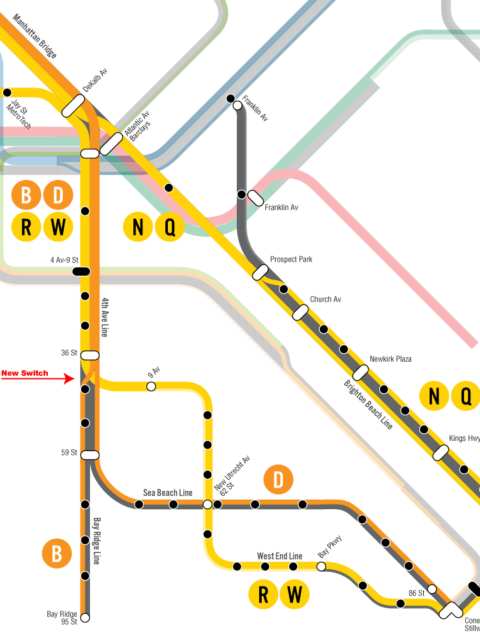
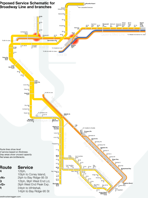
New Future MBTA Map

Tuesday, October 7th, 2008

Back when I made this map for the Boston Magazine challenge for the next big thing in Boston I was pretty burned out about the whole future map thing and I swore it would be my last map. I ended up throwing it together last minute and even though it is my most publicized map I was never happy with it and really wanted no more to do with the whole thing. What a difference a few years make. A little while ago I began to wish that I had made a map that actually expressed what I thought the MBTA could look like (rather than a map just showing the T decked to the halls with extensions that don’t even make sense to build). I also wanted to have a better quality map. The Boston Magazine map was made in Photoshop so it is pixel based and has no curves. I wanted to make a map that was much clearer, cleaner, and vector based so that I could change the size easily.

I started working on this new map until real life got in the way and forgot about it until a few weeks ago when I got an email from the owner of Boston Coasters who said he was a fan and wanted to start a line of products for the FutureMBTA. I realized the map he wanted to use was the one I hated (and would probably look crappy when resized) so I dug through my files and found this new one I had been working on. A few nights of intense redrawing produced what feel is my finest map and probably the (truly) last future MBTA map I will ever make.

Final Future MBTA Map

What makes this map different? For one thing it is the only map I’ve made that incorporates my Green Line/Urban Ring which shows how you can create a network of light rail that will work as both a suburb-downtown connector (the Green and Brown Lines) and an inner city ring line (The Yellow Line). There is also the North-South Rail Link which will enable DMU/EMU service for new stops in inner suburbs where existing commuter rail exists but currently does not serve (This is the “Indigo Line” which runs along side the regular commuter rail). Someone left a comment on one of my sites asking why I hadn’t created a unified master plan for expansion. This is the first step. I have some time off this week so I plan on further explaining what this map proposes, sort of like a thesis for the FutureMBTA.

So pretty soon you will be able to have this on coasters, journals, posters, messenger bags, etc, over at Boston Coasters. I have also created different desktop background sizes available over at FutureMBTA.

Edit:
I also have this map with inverted colors because I think it looks bad ass.

MBTA Map Future Inverted

Changing the role of the MBTA

Tuesday, September 30th, 2008

I think that the purpose of the MBTA needs to be split from an all-encompassing transit authority into purely that of operations. A parent authority should be established that would take the debt burden off the MBTA and allow it to focus all funds on operations and maintenance.

Capital construction and expansion would be handled by this parent authority or by another authority under the parent authority. The purpose of this new authority will be solely for the expansion and planning of transportation throughout the region. The new authority would not be limited to transit expansion but all aspects of infrastructure expansion in the Commonwealth; this includes highway, freight, and water port facilities.

For example the North South Rail Link would make MBTA operations much more flexible and attract many new riders but the construction costs would be so high that it would require the MBTA to realign funds from operation improvements to debt payments, thus limiting the usefulness of the entire project.

Future Visions

Monday, May 26th, 2008

Here is how I see American cities at the middle of the 21st century:

Because of high energy costs, living on large lots in the exurbs will no longer be affordable to the middle class. New policies will go into affect that support infill development in older city centers. As the populations of central cities grows again this will put a strain on already fragile infrastructure. Cities will begin rebuilding mass transit systems they ripped out long ago in favor of the car. People will still have cars but better mass transit along with walkable communities will make driving less mandatory and more affordable.

Gentrification has continued its insatiable march forward. Areas that were once hip are now populated by the middle classes with large new apartment buildings going up where fancy condos once were (and before that vacant lots and burned out buildings). Areas that are today considered the ghetto will be the new hip places where artists and YUPies mingle. The poor that once filled these streets will have been pushed further out into once middle class suburbs.

This will not have come easy. Much like the riots that flamed white flight in the 1960s, new class riots will erupt as the inner city poor feel the pressures of a society that they cannot afford to live in while being pushed out by much wealthier whites. Riots and demonstrations will ensue, and while the city will call calm and understanding, behind closed doors the elites will be helping move the poor out so real estate developers can move in.

This new rebirth of the city will mean that there will finally be political pressure put on restoring streetcars and building new subway lines. Because the poor will have been forced out into the suburbs, where rail service is few and far between, new Bus Rapid Transit lanes will appear on highways. Highways were once crushed with traffic can now afford to lose a lane for the only mass transit available for suburbs.

Suburbs will not die. Though the once urban poor will have moved in, many middle class and wealthy people will still be able to afford living there and will prefer it. Large lots will let people have small farms, usually tended by a local farm company so the residents don’t have to do the work themselves. Most suburbs will have created town centers, much like the old main streets, where residents can walk to. These centers will allow for bus and light rail transit to shuttle residents into the city or to a commuter rail station near by. Because of the class differences, gated communities will be the norm, even more than now.

The children who today are not yet born will become the artists that reclaim the abandoned edge cities of the future. Our massive malls today will be abandoned when energy costs make them unsustainable. Most will be left to decay as the suburbanity around them will be given up. As the inner cities looked to Americans in the 1970s and 1980s, so too will these edge cities look in the near future. But this is exactly the type of place young artists and rebels need to grow and create. Malls will become the new loft spaces. Communities will grow where consumers once walked past retail stores. The massive parking lots, already over grown, will be turned into collective farms. The large roofs will be used for water collection and solar energy. Malls, once symbols of everything wrong with the culture of mass consumption, will be turned into the very ideal of sustainable communities. This lays the ground work for the gentrification of the suburbs in the next 50 years.

High Speed Rail has replaced air travel as the preferred means of getting from cities that are close to one another. Air travel will still be available but will be supported by the government and will only fly long distances or in certain corridors with large amounts of traffic (i.e. Northeast Corridor). Many of the new rail lines will have been built, or are being built, along medians of highways since the land is already owned by the states and the rebuilding of central cities has meant land prices have increased to the point where eminent domain is not as affordable, nor as popular, and option.

Update? Update!

Thursday, October 25th, 2007

It’s been a while since I last posted here but going to school and working full time, as well as building another website, has taken over most of my time, so here is a quick update.

Boston, San Francisco, and Philadelphia transit maps! I finally got around to doing something with all these transit maps I was making. Unfortunately Google is weird about what maps they allow and don’t allow you to embed on a web page so for the time being I am just posting links to the maps. They are just first drafts but all the lines are there. When I have more time I plan on going through and adding more information to each map. Someone asked me to include stations which is on my to do list but because Google Maps already has stations with information about them for most cities I am going to hold off on this.

San Francisco Transit
Philadelphia Transit
Boston Transit

I have also redrawn the New York & New Jersey Subways map so each line has a nice image in the information box that leads to the line schedule at MTA.info.

Lastly, here is a new map of the MBTA as it should look today with the Green Line and Blue Line extensions marked as in planning and the Indigo Line (Fairmount Branch CR) distinguished as an actual rapid transit line. I heard a story that at a community meeting a few years ago someone in the audience mentioned that the branch was not on the map, which confused the people from the MBTA because it was. What the man really meant was that the line was marked as commuter rail (which is what it is) and not rapid transit. If you want to get people to think about it as rapid transit you needed to show it as a rapid transit line on the map the same as the Red or Orange Lines. This doesn’t mean it will be converted to heavy rail, which is not a good idea since this is the only other route into the city from the southwest other than the Southwest Corridor, but you can change the way people perceive the line just by changing how wide the line is on the map (which is one reason I like maps so much).

San Francisco BART

Wednesday, August 22nd, 2007

Continuing with my subway system maps, today I add the San Francisco Bay Area Rapid Transit.


View Larger Map

I am also creating a new section for these maps. I plan on also creating system maps with extensions, like the Future MBTA, but for all these other systems.