
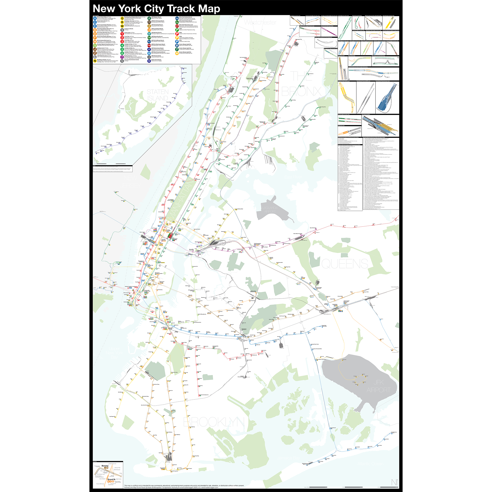
Anyone who rides the subway is familiar with the standard subway map, a cartoon version of the real thing which is designed to aid the rider through their travels. The geography of the subway is such that there are places where many lines are close together which would clutter an accurate map, which results in subway maps expanding these areas. The inverse is true in the outer boroughs where lines can be spaced further apart taking up extra space on a map, so subway maps often condense these areas.
Because of this designed distortion, the subway map as we know it is more of a diagram: the important information like the color of lines and stations are there, but the non-essential details are distorted or removed. The subway map just has a simple line to indicate a train when in reality lines consist of a pair of tracks or more if there is express service; there are also crossover tracks, so trains can switch tracks. Stations usually consist of multiple platforms, sometimes in odd configurations. But the simple subway map condenses this information to show subway lines as simple single colored lines and stations as simple dots.
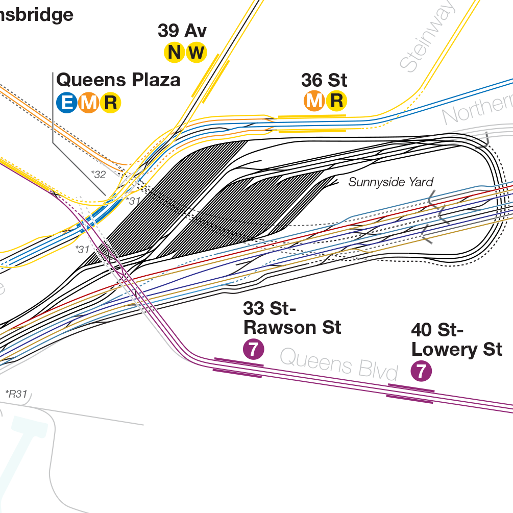
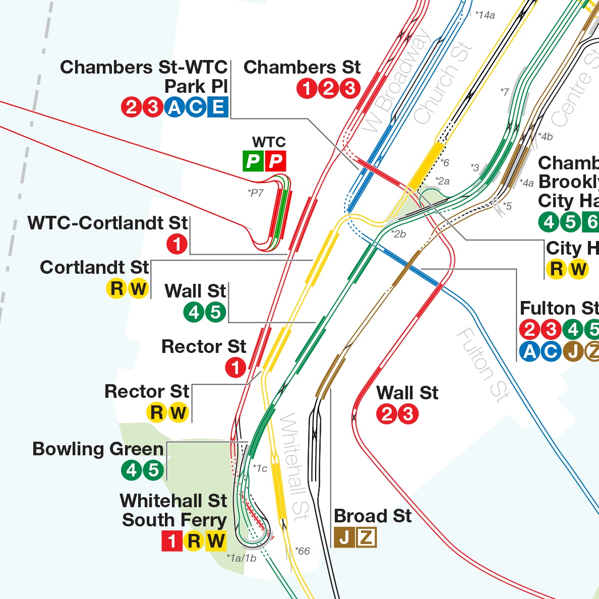
To show a system map as it truly exists, you need to find a track map. A track map is exactly what it sounds like, a map showing the individual tracks, crossovers, and station platforms as they really exist. Track maps are often drawn as simple schematics, with straight lines for rails and boxes for station platforms. Most people would never have to use one, and in fact their primary use is in control towers to display where trains are and which switches are thrown (therefore showing the route of a train). Because the control tower only needs to know where trains are and where they are going, the track maps are even simpler than subway route maps.
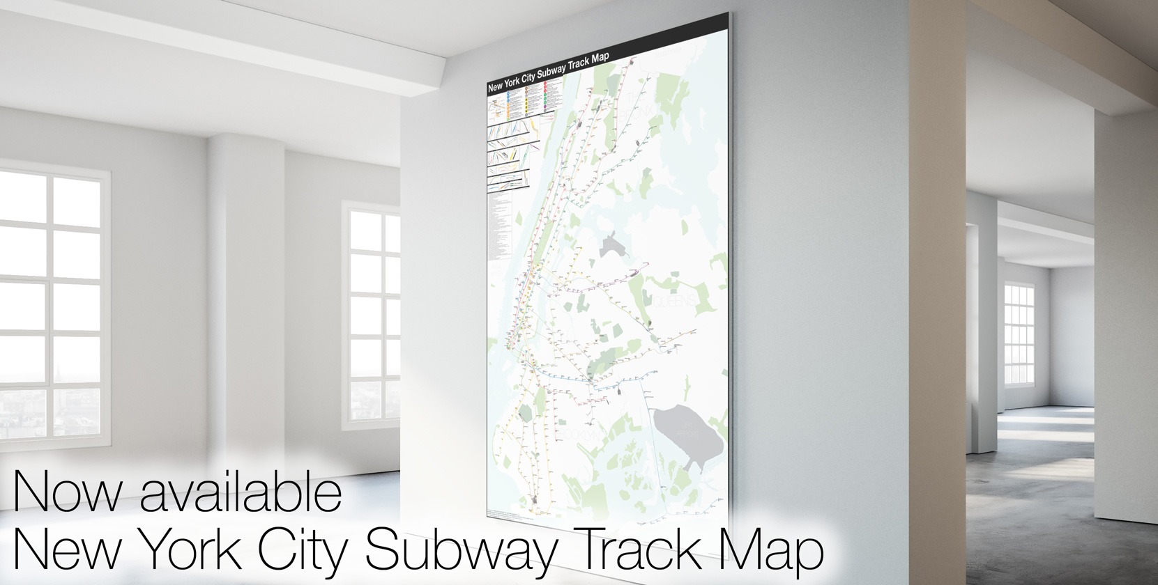
For the subway buff there has been one track map that is considered dogma: Peter Dougherty’s system maps first published in 1996 (having since been updated by others) and available at nycsubway.org as well as in print. Additionally, Robert Marrero designed his own map called 472 Stations, 850 Miles with a cleaner design ethos using 90 and 45 degree angles. In my monk-like research into all things unbuilt I have also found may fan sketches of sections of the subway to show proposed lines. But all of these maps left me wanting; they are still diagrams that have no accurate geography to understand where the trains, tracks, and stations really are.
As I am always tinkering with ideas to expand the subway, I found these inaccuracies too limiting and set out to draw my own track map as accurate as possible. Collecting every historical map I could find, using GIS data, satellite imagery (both current and historic), YouTube videos of fan trips, my own observations looking out the window of trains through tunnels, and talking to retired track workers I was able to draw what I believe to be the most accurate track map of the NYC Subway ever.
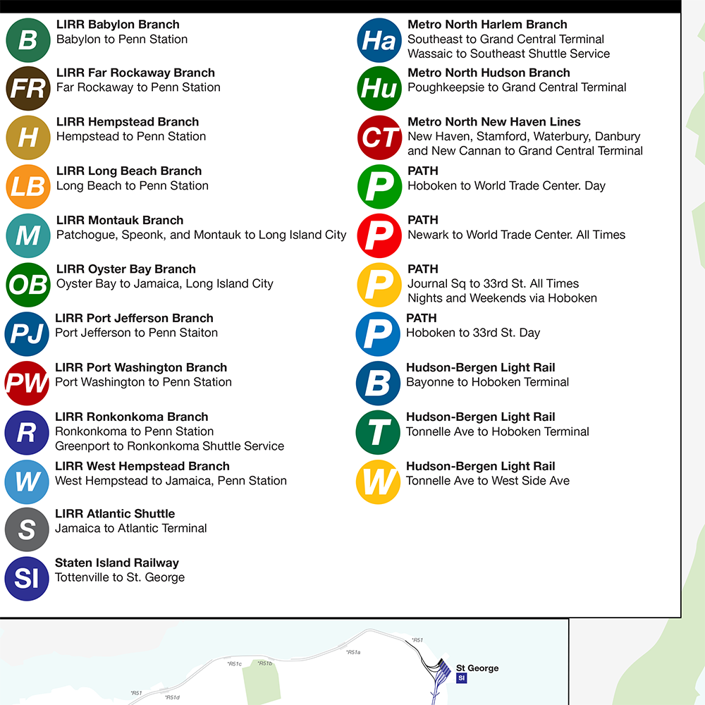
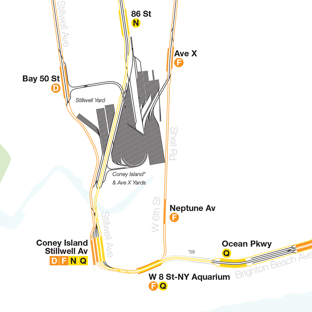
Features I’ve added to the map are all provisions for future expansion and abandoned sections, with a notes section explaining each one, as well as an exploded view for the more complex stations and areas obscured by overlapping tracks. I’ve elected to remove all streets as not to clutter the map and also not to imply that specific sections (such as crossovers) are perfectly aligned to the street grid. While the map is geographically accurate at this scale, tracks had to be spaced far enough apart to read correctly, so lines are not perfect aligned with the widths of the streets. Also, some train yards have been truncated to fit within the geographical boundaries of the map.
As I’ve striven to be as accurate as possible given what I can find any additional corrections or insight is welcomed. Please leave me a comment here or email me at [email protected]
This is just outstanding! WOW! Great job. I noticed a small mistake. In the map key it says revinue instead of revenue.
Numbers 63 and 64 should say outer instead of outter.
Awesome, thank you so much! I’ve uploaded the new file.
You also wrote Leonx Yard instead of Lenox yard.
Where do you see this?
You should mention the trackway at Spring Street that used to hold a fifth track.
West of Bowery there is a bellmouth for a proposed subway line up Third Avenue.
http://www.columbia.edu/~brennan/abandoned/bowery.html
You are welcome. Any time.
The Lenox thing still needs to be fixed, and there is a mistake on the service guide. The 5 operates to Flatbush during the day as well. Therefore, I think that the full service 5 bullet should be at stations to Flatbush.
Ah good point.
Lenox Yard says Leonx.
It says “Lenox Ave Yard” to me.
There is a provision on the New Lots Line for the line to continue eastward. See here
https://en.wikipedia.org/wiki/User:Kew_Gardens_613/New_York_City_Subway_Track_Layout,_Bellmouths_and_Provisions
This is a list of provisions that I have compiled.
I can’t believe I’ve never seen this, lol.
The service guide for the 5 says that it runs from Wakefield, when it runs to Nereid or Dyre Avenue.
Amazing map! Very clean and crisp. One small correction is that the diamond crossover on the (7)/ between Grand Central and Vernon-Jackson is missing
There are a few things on the service guide that should be fixed to be consistent. Since you mention that the E runs local during late nights, the same should be written for the 2, 4, Q and D.
In the Canal Street area, the old trackways for the Broadway connection to the Manny B north tracks. The bellmouth at Canal Street should also be shown.
I have the one there because I’ve seen it. I assume there is a second tunnel but I don’t know how far it goes.
Incredible! Just a few nitpicks…
You’re missing two switches by Jackson Avenue: n/b middle to local south of the station and s/b local to middle north of the station.
1 Av on the L does not have a crossover.
North of Astor on the 6, n/b local trains take the outermost track.
North of 59/CC your s/b local-exp switch is in the wrong place.
You’re missing a switch on the lower level of West 8th.
Thanks! Actually there is a switch at 1 Av, they just installed it.
You made a big error on the 3 and L lines. First of all, the stations are Livonia Avenue (not Pavonia) and Junius Street. There is no free transfer yet.
The ordering of the upper and lower level tracks just west of 9th Av on the D is incorrect.
The two switches north of abandoned Myrtle Av station in Brooklyn are not unused – they carry the B and N.
I have never heard of a crossover at 1 Av on the L nor any plans for one. I strongly suspect your source is incorrect.
My source is a track worker. However I’ll admit it’s been a while since I’ve taken the L through there. I’ll have to double check. It’s also possible he meant they were planning on installing one.
(Re: crossover at 1 Av)
Your source is probably confused with the access shaft/new entrance they’re planning to build at 1 Av. No track configuration changes are expected, nor have any been completed anywhere near there since CBTC went live.
(Also, it’d be helpful to indicate which comment/topic you’re replying to given that there are several here.)
I’ll remove it for now and get a clear answer soon. Unfortunately the comment system isn’t that sophisticated here.
I believe your D5 connections at it’s north end are incorrect- D5 connects to D4 before D3. (36th Street, Queens IND). That is the one thing I see wrong… Great Work!!
Such a great map! But the link to the pdf file doesn’t seem to be working? And I wonder: how did you align the platforms and the tracks so neatly?
Thank you for making this!
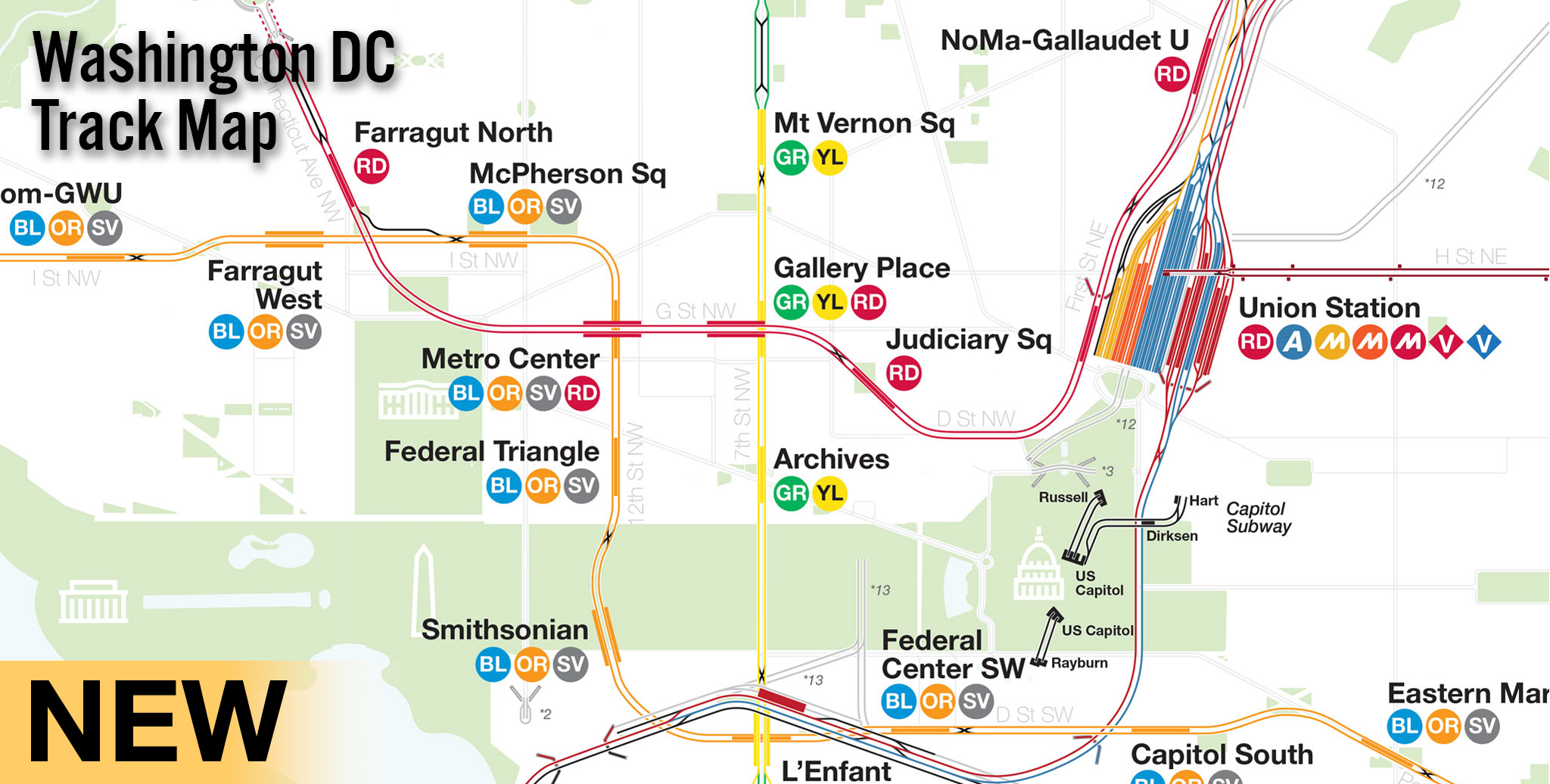
Awesome! Do you have any plans to make similar maps for other systems like the Chicago El or Washington Metro?
If I can find enough accurate information then sure.
Good job, but there are a few things that need to be added, like the local bellmouths to CPW at 57 St- 7 Av. The north track eventually merges into the uptown 63rd street track, but the southbound track does not and begins around the curve the Q makes to 63rd St. And I believe there were former crossovers to the express and local tracks on lex between 103 and 110 St. There may be more so I’ll have to check the new map for anything else that was missed.
On the 7 train, the stop labeled 45th St is actually 46th.
Shouldn’t the 7 stops also have their full names? E.g. “33rd St – Rawson Ave”?
You still haven’t fixed Leonx Yard directly north of the Harlem-148th Street station.
The service guide for the 5 doesn’t mention Dyre Avenue at all. It only goes to Nereid during rush hours. The D runs local via Fourth Avenue during nights, and the M runs to Essex on weekends.
Thanks for adding part of the Bowery thing. There is also a bellmouth directly to the west of Bowery that should be mentioned. Thank you so much!
Oh I just realized what you meant. I’ll fix that in the next update. Thanks for your help.
Here are some things to add for the Flushing Line:
The old trolley loops
old connection to the PRR
Provisions for crossovers
http://nycsubway.org.s3.amazonaws.com/images/articles/steinway16.jpg
I had the loop in but took it out. Guess Ill put it back. What was the old PRR connection? Is there any trace of it? And do you have and specifics on old crossovers/provisions?
I would love to buy a print of this once you have all your updates made!
You are welcome.
I don’t think that there is any trace.
I will give you a few more links to track maps from ERA bulletins.
http://tramway-null.blogspot.com/2012/11/steinway-tunnel-trolley-map-1907-and.html
There is an inspection shed that used to exist
http://tramway-null.blogspot.com/2014/10/pelham-subway-line-track-plan-as-of-1988.html
This is an interesting one.
South of Neck Road there used to be a branch to a racetrack.
http://tramway-null.blogspot.com/2012/02/source-map-sheepshead-bay-race-track.html
Bergen Cutoff http://tramway-null.blogspot.com/2012/08/bergen-avenue-cut-off-of-3rd-avenue-el.html
Sheepshead Bay http://2.bp.blogspot.com/-S49fcrM2q3o/T0Tv2SMGjfI/AAAAAAAAAHE/E2SQQVkK8yA/s1600/SHEEPSHEAD_BAY_RACE_TRACK.jpg
I love it. Would you please consider an inset for the “newish†Fulton Center mess and transfer point? Any help for anyone trying to get around that conglomeration of stations needs as much assistance as they can get. The signage stinks. I’d love to see MTA put up a diagram such as the kind you have here in the insets to assist people trying to transfer. Great work. When will you be selling them?
This map is Outstanding, what will it look like with proposed expansions??
You’ll have to wait to see 😉
On the 7, between 40th and 52nd, the stop is named 46th/Bliss. There are two exits – one on 46th and another on 47th – but it does not touch 45th except *maybe* at the extreme end of the train hanging over top of it (I come from the other direction, so have never taken the time to care that much).
Is your map available to purchase in poster size?
I’m working on it. Im going to make some test prints and see what I can do.
There is a provision for a middle track on 2 Av between 105 St and 120 St. Also the 57 St bellmouths do not connect to the crossovers north of the station and both form directly north of the station. You can say the same for the 4 av bellmouths south of 59 st.
Tiny notes, but you don’t have the portals on the d at the 36 St curve and the Canarsie bound L between Halsey St and Bushwick av. Also at the DeKalb avenue interlocking the B train connection to the downtown brighton track is not colored in. Not sure if you want to fix that as well, but something to note.
You made a big mistake in the service guide. The J does not run express between Myrtle and Broadway Junction. Skip-stop is done in that section.
A few more things. In the service guide, for the C, it says locl instead of local.
On the map, Woodside, should be 61st Street–Woodside. Ditmars Boulevard should have Astoria in front of it, and the station serving Citi Field is Mets–Willets Point.
The station should be Beach 98th Street, not Beach 96th Street.
E. 143rd–St. Mark is really E. 143rd–St. Mary’s Street.
Christopher Street’s full name is Christopher Street–Sheridan Square.
8th Street shoul be 8th Street–NYU
The track for note #53 does not operate under 4 Av. Also the downtown portal on the L between Halsey St and Bushwick Av ends north of Bushwick Av Station.
What do you means about the note for 53?
1) Missing a crossover at 37th and 10th in Brooklyn, visible on Google Maps satellite photos.
2) There are multiple tracks in the yard at 38th and 3rd in Brooklyn, including one that extends all the way to 1st Ave and the Cross Harbor Railroad.
3) Some tracks missing in the Linden Shops area.
Thanks. 38 St Yard was the first one I drew before I knew how I wanted to draw the yards. I’m going to redraw the whole thing in a future update.
Staten Island?
We’ll see.
This is a track map, not a station diagram.
on the 6 its Morrison-Soundiew Aves not Soundview Ave Morrison Ave and its Parkchester-E 177 St. Otherwise its pretty accurate.did you make the mannhattan bronx border on the 1 line by Marble Hill-225 St.its a work in progress dont worry we all love it were just trying to help you make the map better
Thanks, I totally forgot about the Marble Hill border!
I think the J/Z station at Fulton might be backwards on this. The Brooklyn-bound train platform doesn’t require you to cross the tracks to get to from the “main†hallway.
Hello vansnhnookenraggen, I would like to know the apps that you use for your FutureNYCSubway projects because I’m looking foward to do something similar
I use Adobe Illustrator to draw my maps. I’ll often use screenshots of satellite images and Google Maps to trace them.
I work a lot with GIS and I love the NY City Subway system. When I saw this on facebook I got really excited. I think you did a great job. If you need help with your future GIS projects, I will be happy to help out 🙂
I mean at the 36 St curve at 4th Av, the track leading to the Brooklyn Marine Terminal does not operate under 4th Avenue. I accidentally confused that track for the bellmouths for note 53. My fault.
Also Van Siclen Avenue and Norwood Avenue are Z stops and Cleveland St is a J only stop.
Beautifully made NYC Track Map!!!!!!! Waaaay better than my aging “Schematic track maps†when I made available on nycsubway.org 20+ years ago! Granted, it’s a small file size and crammed (Hey, try sending your PDF file using 14.4bps dial-up modem! LOL).
I remembered all the mistakes I made while making it available…your future updated map will reflect any corrections 🙂
I’m no Illustrator user/expert, any way to make express stop little more accurate? For example, 61 St-Woodside, local tracks curves away middle track instead of showing straight….god forbid if we stand few inches wide platform LOL!
Keep up the great work!!!!!!!
Thank you for your work! You’ve been a true inspiration.
This is incredible work. The only thing, in my opinion, would be a google api overlay.
Thanks for producing this! It is a great map. I am always impressed by the fact that the decisions regarding where these tracks go, and how many of them there are, were mostly made on the order of 100 years ago.