

The first futureNYCSubway was more a look at what had been proposed and various alternatives rather than a realistic plan. It was basically a thought experiment about all the different ways the system could be expanded. When I finished the project in 2010 I was pretty exhausted with the New York subway. Over the next couple of years as I explored more of the city and saw the actual needs of the system clearer I began to gradually come back the system expansion plans I developed. The first FNYCS plan was what could be possible with money as no issue. Back in the real world where it is basically the only issue I realized I needed to distill out more realistic ideas that could use existing infrastructure better and develop lines that served the growing areas of the city while better connecting the outer boroughs. As traffic to the CBDs of Manhattan plateaus and a ring of neighborhoods along the East River waterfront develop from Long Island City, Williamsburg, and to Downtown Brooklyn I realized that inter-outerboro service needed to be looked at closer. Projects like the Triboro RX which have sat on the drawing boards for years are a good start but I realized that strategically extending certain lines with extra capacity could do the same job while at the same time commanding higher ridership numbers and creating one or two seat rides (with very simple transfers) to these growing new centers.
At the same time the subway now sees its highest ridership levels ever and capacity has been reached on many lines. Improved signal systems allow for more trains but this will only be a band-aid in some places like Long Island City and Williamsburg where gentrification has exploded over the last decade and will only continue to do so. The legacy of Mayor Michael Bloomberg is being debated in the waning days of his administration but the fact is that as the city becomes safer and more popular than ever there will continue to be growth.
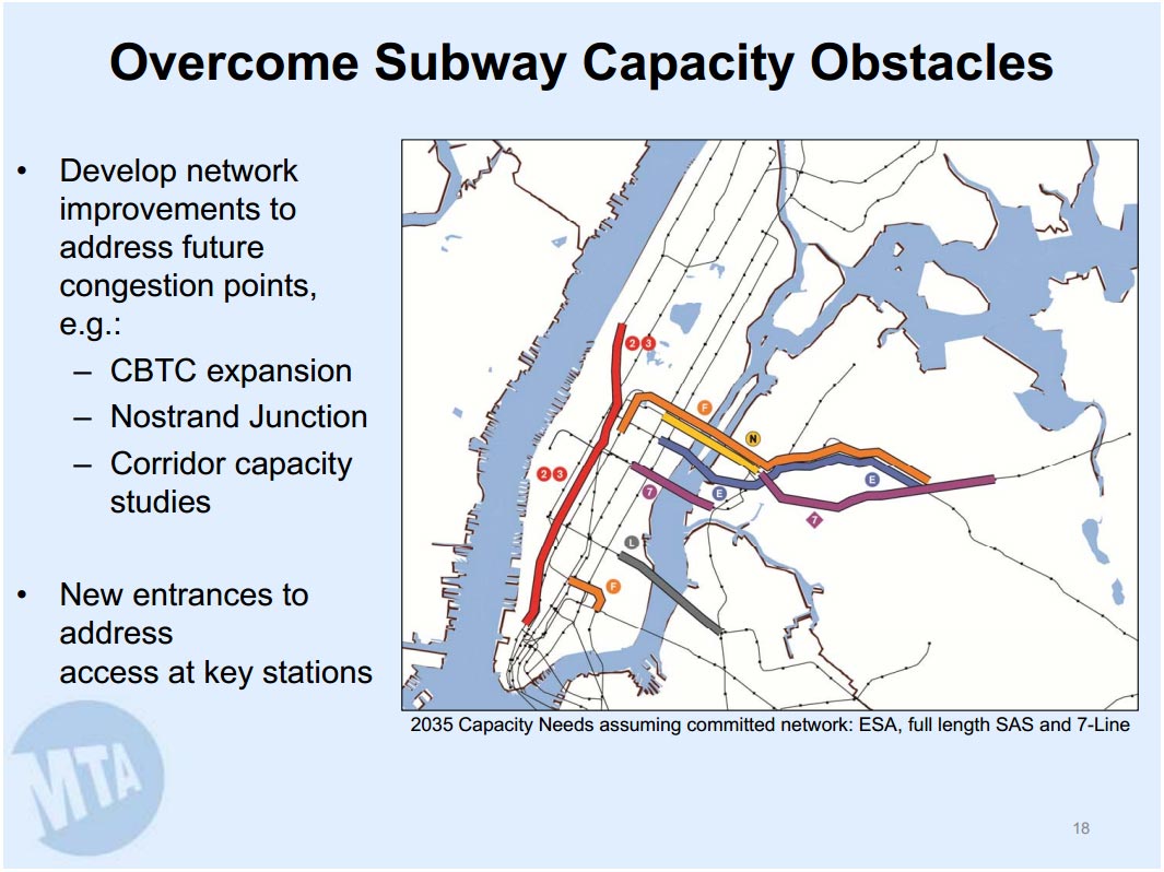
The MTA recently put out a document outlining issues it sees coming up in the next 20 years and to no surprise the subway tunnels connecting Queens and Brooklyn to Manhattan will be maxed out. Even today at the Bedford Ave station on the BMT L line one must wait for multiple trains to pass before there is space. New lines were planned generations ago but the financial realities of an aging system with terrible funding sources gives way to little improvement where it is needed. Small actions like extending the M train from Ridgewood to midtown Manhattan have shown the value of increased transit options as the population of northern Brooklyn grows in part because of improved subway access. But how long until what these small fixes aren’t enough?
The futureNYCSubway v2 aims to take a closer look at the issues the system is facing while taking into consideration the limitations to subway expansion today.
2nd Ave Subway
As of this writing the opening of the first phase of the 2nd Ave Subway (SAS) is 3-4 years away. This segment will take the BMT Broadway Express (Q) train and run it up to 96th St at 2nd Ave. Already local politicians are starting to make noise about finding funding for the second phase which should be less expensive and less intrusive as much of the tunnels from 96th St to 125th St were dug in the 1970s and have sat vacant ever since.
The issue after Phase 2 is built is how to find funding for Phase 3 and 4 which would extend the line south from 63rd St to Hanover Sq in the Financial District, creating a new T train. Phase 3 and 4, as planned, would be almost three times as long as Phase 1, cost vastly more money and take years longer. The glaring issue that I’ve had with the SAS all along is that there is no express track. Not even a third track, like many elevated lines have, which would allow rerouting trains when the line gets backed up. If one train goes down the entire SAS is stuck.
Phase 3 is an opportunity to right this wrong by building a 4 track subway from 57th St to East Houston St. North of 57th St the line would connect to the existing SAS to 125th and to the existing 63rd St Tunnel to Queens. The additional tracks would then be connected to the 60th St Tunnel which is used by the N and R trains for local service to Astoria and Forest Hills, respectfully. Ridership along the BMT Astoria Line has increased dramatically and adding a direct connection to the SAS would take major pressure off the 59th St/Lexington Ave station on the 4/5/6 as a transfer point. Â Not building an express track would mean that, when the need inevitably arises, the costs of building one after the fact would be prohibitive. Â It’s going to be expensive to build Phase 3 no matter what so let’s just get it right.
At the southern end of Phase 3 the SAS would be woven into the IND 6th Ave and BMT Jamaica Lines as originally envisioned by modifying the Chrystie St Cut. SAS trains would terminate at Grand St (Phase 4 would continue south from Grand St to Hanover Sq), connect to the Williamburg Bridge at Essex/Delancey St, and head to Williamsburg via a new tunnel under the East River which would also connect to the IND 6th Ave line at 2nd Ave (a provision built for the IND Second System).
South 4th Subway
The bulk of SAS traffic coming from Brooklyn should come from northern Brooklyn as opposed to southern Brooklyn. By this I mean it would be very easy to connect the SAS to the Manhattan Bridge and divert trains from Brighton Beach or Coney Island through 2nd Ave. But this would only move existing service around and leave northern Brooklyn still choked with just the L train. Any new capacity in Manhattan should be used to address traffic coming from northern Brooklyn. It’s time to build the South 4th Subway.
A 4 track subway from East Houston St under the East River to South 4th St and Havermeyer St. At Havermeyer St the line would merge with a new connection to the tracks running over the Williamsburg Bridge via a portal built on the Brooklyn side of the bridge. A South 4th Subway would be the opportunity to relocate the elevated tracks of the BMT Jamaica Line from Marcy Ave to Lormier St. This new trunk line would run from Havermeyer St to Union Ave/Broadway Station (using the built but never used shell station) and under Sternberg Park to Boreum St. The tracks would then split with local tracks running to Bushwick Ave at Boerum St and express tracks straight under private property to Bushwick Ave at Flushing Ave. Local tracks would branch off so that 6th Ave trains can connect to the BMT Canarise Line and run to Myrtle-Wyckoff St while SAS trains connect back with the trunk line at Broadway. Just south of the intersection of Bushwick and Flushing Aves the subway would split with 3 tracks rising to the surface to connect with the existing elevated line just west of Myrtle-Broadway station and 4 tracks continuing to Stuyvesant Ave.
This complicated interchange would allow Jamaica bound trains to merge with Myrtle Ave, Utica Ave, and Canarsie bound trains and allow for simple transfers with express trains bypassing Bushwick and local trains taking pressure off of Bedford Ave. The growth of Williamsburg and Bushwick has put the L train beyond capacity. Connecting 6th Ave trains to the eastern section of the BMT Canarsie Line (serving the quickly growing stations of Morgan, Jefferson, DeKalb, and Myrtle-Wyckoff) would take the pressure off trains when they get to Lorimer and Bedford. This new service would also have a direct connection to the IND Crosstown G train and siphon off transfers at Metropolitan Av, reducing loads on the L further.
Relocating the western end of the BMT Jamaica Line would speed up service and allow for a variety of routing options as the Centre St Subway in Manhattan is lightly used. The demolition of the elevated track would raise property values in an already growing neighborhood and the new South 4th Subway would finally give the area the transit capacity to afford such growth. Already today the M train has allowed a one-seat ride from Bushwick to Midtown Manhattan. A South 4th Subway would allow for ever more growth and take pressure off of the packed L trains.
Utica Ave Subway
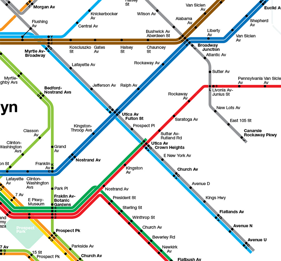
The original plan for the Utica Ave Subway used a four track subway out to Flatbush connecting to the IND 6th and 8th Ave Subways in Manhattan. Plans for the line have evolved over the years including the original IRT plan to extend the IRT from Utica Ave at Eastern Parkway to Kings Highway. In the outline above for the South 4th Subway I end the line at Broadway and Stuyvesant Ave as a 4 track station. From this point the line would continue south to Utica Ave as a 3 track line with rush hour express service. This 3 track subway would have SAS trains running express and 14th St-Crosstown trains, a new branch off the BMT Canarsie Line, running local.
South of Church Ave much of Utica Ave is lined with 1 or 2 story commercial buildings (“tax payers” goes back to when land speculators would buy land and put up a cheap commercial development that would cover property tax while they waited for the value of the land to increase). What I would propose as a more affordable solution is to buy up these properties and build a continuous structure from some point south of Church Ave to Flatbush Ave which would be 2 or 3 stories tall and have the trains running along the roofs while allowing for commercial development below. This way the line could be built for significantly cheaper than a subway but remove the blight that comes with traditional elevated trains. An added bonus is that the ROW then becomes an income stream with space for retail and commercial businesses.
Bronx Extensions
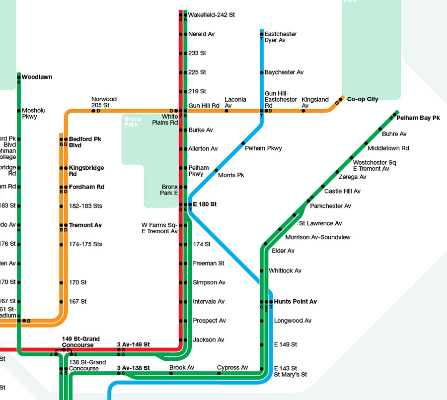
Extending the SAS into the Bronx will be limited to one train service due to the fact that the first and second phases of the SAS are being built with only 2 local tracks. Because of this limitation the most affordable option for SAS Bronx service and the one that would have the greatest impact on easing traffic on the IRT Lexington Ave Line would be to build an at-grade superexpress line from 125th St to Hunts Point along the Metro North ROW through the South Bronx and Port Morris up to the East 180th St IRT station using the abandoned platforms. The SAS service would then take over the Dyre Ave Line currently used by the 5 train as originally envisioned by transit planners when the old New York, Westchester & Boston Railroad line was added to the subway system in 1941. This would allow for transfers at 180th and Hunts Point with express service bypassing the South Bronx thus reducing the amount of commuters on the 5 and 6 trains through Lexington Ave.
The success of the Select Bus Service from Inwood to Coop City in the Bronx has shown the need for improved cross-Bronx service. With this in mind the IND Concourse Line (B/D trains), which terminates at 205th-Norwood, should be extended east as originally planned under Burke Ave running to East Gun Hill Road to Coop City. This 2 track extension would finally give Coop City a subway connection and allow for transfers along the IRT White Planes Line (2/5) and the Dyre Ave Line (outlined above). Currently the 2 train is the only train that connects the eastern Bronx with the west side of Manhattan. Extending the Concourse Line east would give commuters a quicker and redundant way to reach the west Bronx and west side of Manhattan.
Queens Superexpress, Rockaway Branch and IND Queens Blvd Line Extensions
The Queens Boulevard Subway has seen the most consistent grown as a whole over the last couple decades. New immigrants have settled in central Queens and new luxury developments have sprouted in Long Island City. All of this growth has put a strain on not just one subway line but all four East River tunnels headed into midtown. This growth in western and central Queens poses a unique problem in terms of service because eastern Queens remains woefully undeserved by the subway; how can we extend service into new areas without compromising service in the east.
The first solution would be to complete the Queens Superexpress Line. The Superexpress was planned as far back as the 1950s. Between Woodside and Rego Park there exists 2 fallow track beds along the Main Line of the LIRR. By building a 2 track subway line along this route (which would require moving tracks for the LIRR Port Washington Line) the IND Queens Blvd Line suddenly goes from 4 tracks to 6. The 63rd St Tunnel was originally built for the Superexpress Line but funding ran out. The tunnel was eventually connected to the IND Queens Blvd Line instead (the F train makes this run today). Â This partial solution has not helped much and one can argue that it has made things worse since now Crosstown (G) trains no longer run out to Forest Hills but instead require a long transfer at Court Sq.
The Superexpress would have four parts to it:
- A connection to the 53rd St Tunnel at Court Sq (with the E/M platform being converted into a 4 track station) and a connection to the 63rd St Tunnel (F train and future SAS trains).
- A trunk line which would run along the LIRR Main Line with a station at Woodside to Forest Hills. Under Yellowstone Blvd the line would merge with the existing IND Queens Blvd Line before 71st Ave-Forest Hills Station.
- At Rego Park the line would split with a branch running south to the Rockaways along the abandoned LIRR Rockaway Line. The Rockaway branch would also have a connection to the IND Queens Blvd Line Local tracks using the provisions built into the existing tunnels when the IND Queens Blvd Line was originally constructed. This connection would allow the reactivated Rockaway Branch to have two trains, one running local via Queens Blvd and the other running express to midtown via the Superexpress. As Rockaway Branch trains would, in this plan, use the 53rd St Tunnel the spacing of these trains could be staged so that service to Ozone Park and the Rockaways would have regular headways while not over taxing the capacity of the 53rd St Tunnel.
- The connection at Forest Hills would allow a third express train to run east of Forest Hills to Jamaica. The original routing of the E and F trains under Hillside Ave could be restored and the Hillside Ave subway could then be extended further east as either a subway or elevated track. The Superexpress train could then be sent through the Archer Ave subway in downtown Jamaica and further extended to Rosedale along the LIRR Atlantic Branch as originally envisioned.
Another possible extension of the IND Queens Blvd Line using existing tunnels would be to extend the local train (R) from Forest Hills through the Jamaica Yards and into a new tunnel under 73rd Ave out to Francis Lewis Blvd.
Additionally, the Archer Ave Line which is used by BMT Jamaica (J/Z) trains could then be extended east to Belmont Park with similar skip-stop service.
10th Ave Subway and 86th St Crosstown Line
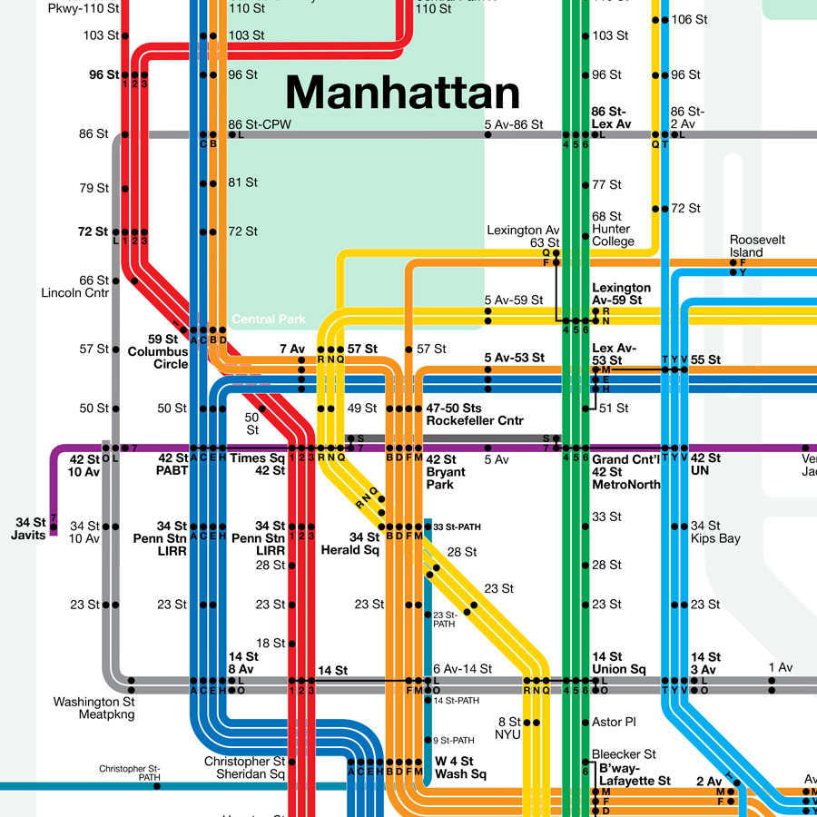
In the recent MTA 20 year outlook for congestion issues the IRT 7th Ave-Broadway Line between 72nd St and Penn Station is predicted to see the most congestion on the west side. As the Hudson Yards brings more and more development to the west side of Manhattan over the next 20 years the current infrastructure will become strained. The IRT Flushing 7 Train extension will help for only so long. Hells Kitchen and the Upper West Side will see a boom in commuters headed for the Hudson Yards and eventually a new subway will be needed. A 10th Ave extension of the BMT 14th St-Canarsie Line will be the best option. In the original futureNYCSubway plan I envisioned the line going up 10th Ave to some point in midtown and making its way over to Long Island City.
This new alignment adds another element to the plan. Â Moving the line up to 72nd St to take traffic away from the congestion parts of the IRT 7th Ave-Broadway Line and then crossing over to the east side up at 86th St creates a crosstown line for the Upper East and West sides. From here the subway would head to Astoria and run under Broadway to Northern Boulevard. Â While the subway itself would be 2 tracks, a third track at 72nd St/Broadway and 86th St/2nd Ave would allow for a crosstown shuttle service should the need arise.
Besides the benefit of a crosstown subway at 86th St the new subway to Astoria will act as a bypass for commuters around the soon to be congested areas of Long Island City and the East River tunnels at 53rd, 60th, and 63rd Streets. A transfer at Northern Boulevard station on the IND Queens Blvd Line will siphon off commuters from Corona, Forest Hills, and Jamaica and allow them a ride around midtown.
Northern Blvd Line to LaGuardia
The trunk section of the Northern Boulevard Subway will run from Broadway to 108th St as a 4 track line. At Northern Boulevard Station two sets of tracks will combine; the first from the 10th Ave-86th St Crosstown Line outlined above and the second from a new connection to the IND Crosstown Line (G) at Court Sq in Long Island City. The G train extension will have a stop at Queens Plaza, a new station built next to the existing Queens Plaza Station, and then run express to Broadway/Northern Boulevard. The 10th Ave trains will run express to Mets-Willets Point while IND Crosstown trains will run local to LaGuardia Airport.
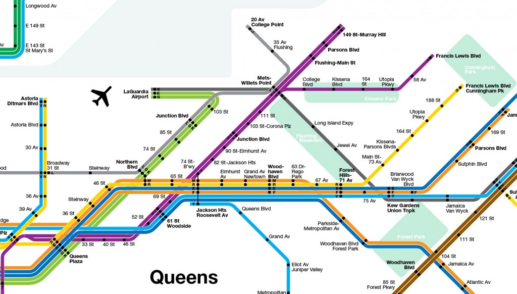
Flushing Extensions
The Northern Boulevard Line will branch off at 108th St and express trains will then run up to College Point along Linden Place as mostly elevated to 20th Ave. The way the tracks are to be laid out would allow for a shuttle train to run from Mets-Willets Point to LaGuardia Airport much like the AirTrain except this would be a free transfer.
The IRT Flushing 7 Line will also see two extensions. The current terminal at Main St-Flushing was never built as a proper terminus as the line was always intended to be extended east. A subway under Roosevelt Ave to Northern Boulevard would allow the the construction of a proper terminal for trains and move bus transfers back outside of the congested central Flushing shopping district.
Using the non-revenue service tracks leading from 111th St to the train yards between Roosevelt Ave and Arthur Ashe Stadium a new branch line would be created and extended as an elevated line running through the Kissena Park Corridor to Francis Lewis Boulevard. A 2 track elevated line would have longer spacing between stations would better serve the suburban area of Queens without running above the streets creating blight. Running the line through the park would allow for landscaping that would minimize the visual and noise aspects of the line.
Brooklyn-Queens Interboro Connections and the Triboro RX
One of the major drawbacks of the subway system in New York City is that it’s Manhattan-centric. While this is based on the fact that most of the traffic is headed into and out of Manhattan there is still a need, a growing need, for better interboro connections. The Triboro Rx plan has been making the rounds lately (thanks in part to my outline of the line in the first futureNYCSubway proposal) but I do not feel that the line is worth the cost. There are two small connections which I feel would have the biggest impact for the least cost.
The main problem with the Triboro Rx Line is that it won’t be anywhere near as cheap and easy to build as people think. For one the ROW is in many places narrow and goes along the backyards of many residential communities. Â Expanding the ROW would turn many neighborhoods against the plan. The rail line currently there is not a subway line but a freight line and by US law you cannot run subways on freight lines. This means that if the line was to be run as a subway it would require a complete new build from one end to the other, thus negating the affordability aspect of the plan. The other problem is that the line itself doesn’t connect any places within the city where people want to go. As such the line, if built, would end up being a commuter rail shuttle service with awkward transfers and that would never justify the costs.
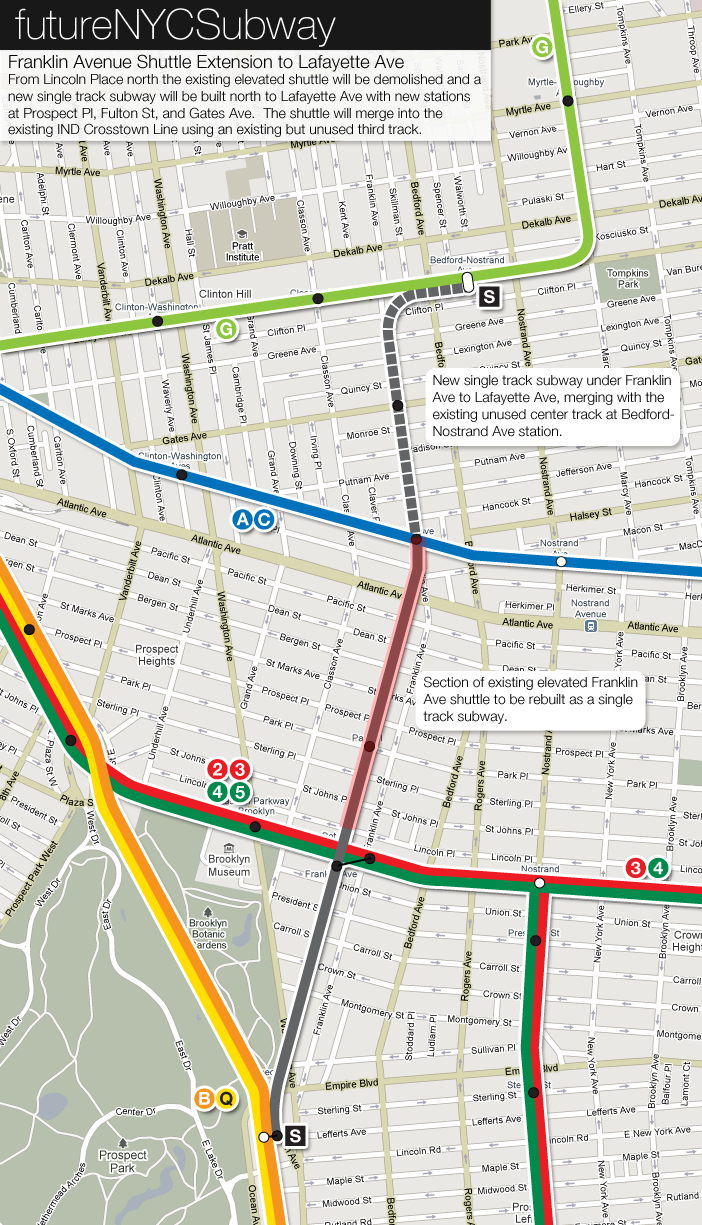
The alternatives I propose are much more surgical in nature. The first would be to use the existing Franklin Ave Shuttle which connects the BMT Brighton Beach Line to the IND Fulton St Line (formerly connecting to the Fulton St elevated line and before that a steam railroad from Atlantic Ave to Brighton Beach) and rebuild the line as a subway, extending it north through Clinton Hill to Lafayette Ave and connect it to the IND Crosstown Line using the provisions for such a connection at the Bedford-Nostrand Station.
This connection may seem trivial at first but if you consider that the Crosstown Line is the only subway that runs from southern Brooklyn to norther Brooklyn. You can only transfer to this line if you are coming from southwestern Broonlyn and west of Ocean Parkway. That leaves a large section of Brooklyn, Flatbush, Sheepshead Bay, Brownsville, Crown Heights, and much of Bedford-Stuyvesant with no connection at all to the one train which runs to northern Brooklyn and Queens. Commuters are forced to take a slow bus through the entire run of Brooklyn. The connection under Franklin Ave would mean that a local train could run from Brighton Beach to Long Island City with no transfers. Passengers that would normally have to take a long bus trip from southeastern Brooklyn can now take a quick bus ride to the BMT Brighton Beach Line, or transfer from the IND Fulton St or IRT Eastern Parkway Lines, and get to northern Brooklyn and LIC in half the time. This small connection would revolutionize how people in Brooklyn could get around the city.
The second connection would be to extend the BMT Myrtle Ave elevated line (M) from Metropolitan Ave to Roosevelt Ave in Jackson Heights along the freight ROW through Middle Village. This connection would use the built-but-never-used terminal at Roosevelt Ave (an abandoned section of the Second System) and allow commuters from central Queens a way to bypass LIC and midtown Manhattan when traveling to norther Brooklyn, the LES, lower Manhattan or even downtown Brooklyn. As such the extension would take pressure off the East River tunnels from Queens to midtown.
Staten Island RR North Shore
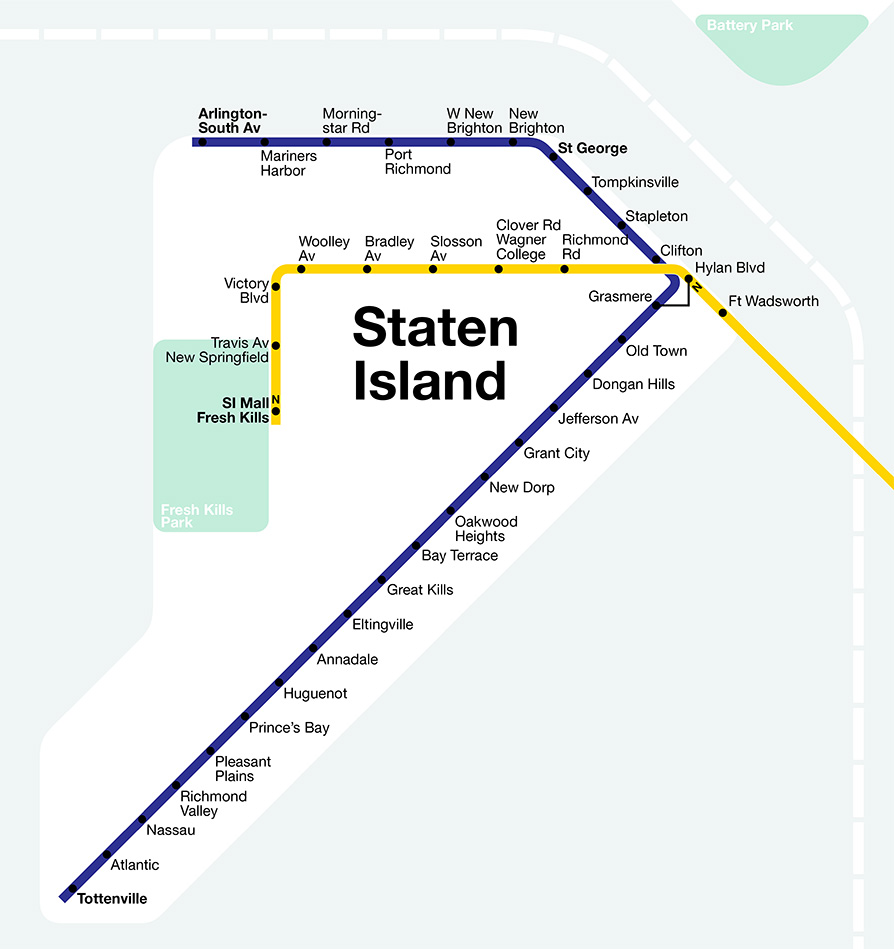
The most obvious and affordable option for Staten Island is to reactive the North Shore Branch of the Staten Island Railroad. I outline the idea further in my original post for the futureNYCSubway.
Other options would be to extend the Hudson-Bergen Light Rail over the Bayonne Bridge to serve northwestern Staten Island. Another would be to extend reactivated North Shore trains to Newark, NJ as a way to give islanders another option to get off the island and as a way to acknowledge that many trips off Staten Island are headed to New Jersey and not into Manhattan.
When the BMT 4th Ave Subway was built there were two provisions left for a future tunnel to Staten Island. Just south of 59th St Station there is purported to be bell mouths left for a tunnel under 67th St to St George. The second provision is that while the 4th Ave Subway has only 2 tracks between 59th St and 95th St the tunnel itself was designed to be expanded to 4 tracks should the need arise. While this second option may be more disruptive to Bay Ridge I feel that an expansion of the 4th Ave Subway and extending it under the Narrows to Staten Island would be more of a benefit to Bay Ridge as this would extend express service to 86th St.
The tunnel option I prefer would run parallel to the Verrazonno-Narrows Bridge from the southern tip of Bay Ridge to Fort Wadsworth on Staten Island. The route the line would then take would run along the Staten Island Expressway in either a subway along the frontage roads or along an elevated track along the median. The line would run out to Richmond Ave where it would then swing south to terminate at the Staten Island Mall. This central routing would be better at serving the Island due to the suburban development patterns it has and would act as a de facto commuter rail line (more like Washington DC or BART in the San Francisco area).
Conclusion
The idea for the second version of my futureNYCSubway series was to take a more realistic look at where the subway system is today and where it should go. Obviously money is a major issue facing the system and it will take a visionary and powerful force to get even the smallest expansion built. But that isn’t impossible. These ideas that I’ve built out of past plans and by looking at current problems; some proposals I think are stronger than others: 4 track 2nd Ave Subway, Franklin Ave connection, Superexpress Lines. Others are nice to have but will take time. Northern Brooklyn continues to gentrify and even reactivating the Chrystie St Cut for 6th Ave service out to Metropolitan Ave will only go so far.
The other thing I wanted to do was to present my ideas in a much more visually relatable way. The maps I used in the first series were of my own creations but I immediately saw the downside of this. If I had used the current map and expanded out from there, as I did with my futureMBTA project, then I feel like my ideas would have spread faster as people would recognize instantly the new routes I proposed. Unfortunately the current map the MTA uses is a mess, abstracted and distorted with no order, and would have required me to redraw the entire thing anyway. The solution was to use the updated Vignelli map, the 2008 version of the historic 1972 map which was much less accessible and deemed a failure. The 2008 update is everything a transit map should be; clean, clear, easy to navigate, and downright pretty to look at. I realized that this was the only map that I could use to express my plans in a way that people would be comfortable seeing. The MTA uses the new Vignelli map for its online Weekender service updates because it is much easier to see how each line is affected by changes. With my plans I needed to show how each line could interact with the whole system and how an extension here could affect another line elsewhere. I didn’t use the map with permission from Vignelli Asc. but I do credit them. The map I’ve created is for educational purposes only and not for sale. I thank them for their brilliant work and my expansion map is a testament to their brilliant work.
The futureNYCSubway
- Introduction
- IND Second System
- Post War Expansion
- The Second Ave Subway: History
- The Second Ave Subway: To The Bronx and the Nassau Line
- Brooklyn: Bushwick Trunk Line
- Manhattan: West Side and Hudson Crossings
- Queens: Flushing Trunk Line
- Staten Island: The Last Frontier
- TriboroRX and Atlantic Ave Super-Express
- Conclusion: the vanshnookenraggen plan
On your great map you made a mistake. Eastchester Dyre Av is spelled Dyre Av when on your map it is spelled Dyer.
Kyle Anthony Calderon liked this on Facebook.
Kate Farrish liked this on Facebook.
Ken Comia liked this on Facebook.
Steven Otto liked this on Facebook.