
Because of how and when Brooklyn developed in the 19th Century it has today one of the most extensive subway and elevated rail networks in the entire nation, and it is only one borough of the city. So many lines criss-crossed Brooklyn back in the day that, unlike many other cities who’ve expanded service over the last century, Brooklyn has actually lost miles of tracks due to the dismantling of elevated lines through Bedford-Stuyvesant and Borough Park. Still, Brooklyn remains one of the most well served areas in the nation in terms of subway lines. However, there are still major sections of Brooklyn that developed after World War II and outside the range of subway service.
The city foresaw this development and planned to build subways to Flatbush, Flatlands, and Sheepshead Bay but was stopped by the Great Depression and changing priorities (e.g. the car). When the Independent subway released its grand expansion plan in 1929 it included a major trunk line though northern Brooklyn that branched out to reach the Rockaways and Sheepshead Bay. The lines connected to the 6th Ave and 8th Ave Subways had at one time up to 8 tracks servicing four different subways branching off into Brooklyn and Queens.
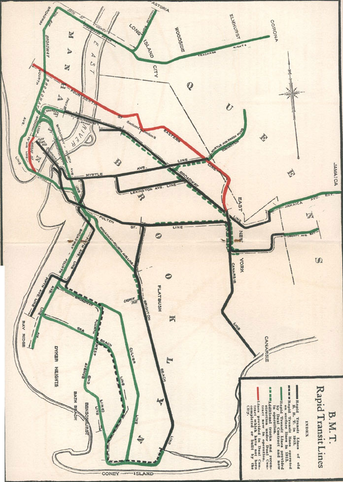
Much has changed in northern Brooklyn since those days. Back then there were three major elevated lines in northern Brooklyn; the Jamaica Line elevated which still runs today (J/Z trains), the Myrtle Ave elevated which once ran all the way from dowtown Brooklyn to Metropolitan Ave but was cut back to Broadway in the 1950s (M train), and the long gone Lexington Ave elevated line which ran through Bedford-Stuyvesant along Lexington Ave and was also torn down. Many of the neighborhoods of northern Brooklyn suffered severe population drains after World War II. Much of the industry left and by the 1980s the area became one of the poorest in the nation.
It is amazing then how far we have come within a generation. Due to the low cost of real estate and the availability of large loft warehouses, Williamsbug has gone from a no-mans land to being the newest, hippest neighborhood in the city. During the 1990s due to waves of new immigration from South America, Bushwick began to stabelize. As gentrification moved east from Williamsburg areas of Bushwick and Bedford-Stuyvesant began to gentrify. Today the area’s population has grown dramatically fom 10 years ago and ridership levels on every subway station in Williamsburg, Bushwick, and northern Bedford-Stuyvesant have risen. This now presents the problem: how will the century old transit infrastructure handle this new growth?
Now I am bringing this proposal back, a new trunk line serving northern Brooklyn with branches out to Queens and southeastern Brooklyn that will replace the antiquated Broadway and Myrtle Ave elevated tracks and allow for better local service and faster commutes from the far reaches of the city. This new subway is called the Bushwick Trunk Line.
6th Ave and 8th Ave Subway Connections
The original proposal from the 1920s was called the South Fourth St Subway for the street under which it ran. It began in two places in Manhattan, both vestiges of the IND Second System. On the 6th Ave Line at 2nd Ave station there are 2 platforms and 4 tracks. Only the outer tracks have ever been in service with the inner tracks used, until 2010, as a terminal for the V train. The inner tracks were originally built to service trains coming from Williamsburg via a tunnel under the East River. This is the first part of the Bushwick Trunk Line proposal. The second is over on the 8th Ave Line. After Canal St station on the 8th Ave Line the express and local tracks diverge into two separate tunnels. Today the A and C trains run on to Brooklyn through on one set of tracks while the E uses the other set to terminate at World Trade Center. It is these tracks, the World Trade Center tracks, that were originally supposed to head east under Worth St. The so-called Worth St Subway made a short jog along Worth St to East Broadway and down to Grand St where it dove under the East River towards Williamsburg. Both of these tunnels, at some point in Williamsburg, would have come together to form a 4 track subway under South 4th St. There were various proposals for where this would happen and various schemes for how many trains would run. The line would have been able to handle 2 express and 2 local with branches out to the Rockaways and Sheepshead Bay.
Because my proposals encompass as vaster area then along South 4th St I’ve taken the liberty to rename the proposal the “Bushwick Trunk Line”. A trunk line is a main line of a railroad that is created by combining many different passageways that branch off at some point. For instance the Lexington Ave Subway is a trunk line because it combines the 4/5/6 trains in a subway under Lexington Ave. The Bushwick Trunk Line would combine trains from central Queens, Jamaica, Flatlands, Sheepshead Bay, and Bushwick into a single massive subway and redistribute them into Manhattan.
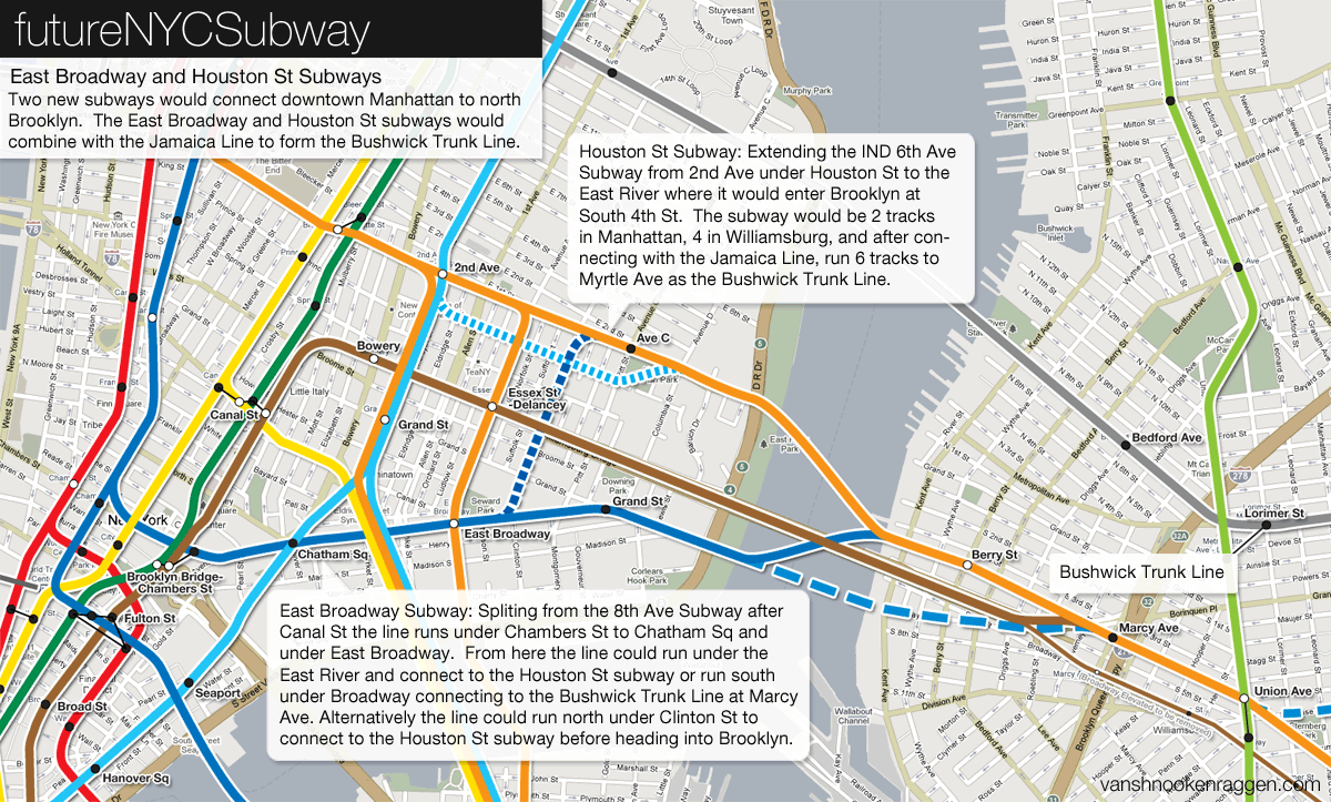
To update the original plan we have a few different options. On the 6th Ave Subway a new tunnel should still continue east along Houston St across the East River to South 4th St in Williamsburg. A station will be placed between Aves B and C to give subway access to one of the only areas of Manhattan still without close subway access. A proposal from the 1930s also brought in a connection with the Second Ave Subway which would branch off before the 2nd Ave station at Houston St and run parallel to the 6th Ave extension under Stanton St. The two subways would combine somewhere under the East River.
The 8th Ave Subway connection would be shifted south from the original proposal under Worth St to Chambers St where a new transfer facility would be constructed connecting the Lexington Ave Subwayand the Jamaica/Centre St Subway. From here the new subway would continue along the original route under East Broadway to Grand St and under the East River to connect with the 6th Ave extension to form the bulk of the Bushwick Trunk Line. Alternative alignments would have the subway running under Clinton St and merging with the 6th Ave extension before the East River or running the 8th Ave extension along Broadway in Williamsburg and connecting with the 6th Ave extension further east.
While in Williamsburg another subway connects to the Trunk Line; the Jamaica Line which today runs on an elevated track. A new portal would be constructed at the Brooklyn approach of the Williamsburg Bridge to connect the tracks on the bridge to the new subway. The elevated tracks would be torn down.
For those keeping track of the tracks, there would be two, 2 track tunnels under the East River meeting at a single 4 track station at Berry St and South 4th St. Continuing east the Jamaica Line would connect adding 2 additional tracks making 2 local tracks and 4 express tracks. These 6 tracks would run to Union Ave where at the Broadway Station on the IND Crosstown G Line is the shell of a 6 track station which was built in anticipation of the South 4th St Subway.
If you think about this in transportation planning terms then the Crosstown Line suddenly becomes a lot more useful. There is very little traffic between downtown Brooklyn and Long Island City but this was not supposed to be the case. The South 4th St subway was meant to meet with the Crosstown Line between downtown Brooklyn and Long Island City which would have added much more traffic to the line, distributing commuters more efficiently and taking pressure off transfer points in Manhattan.
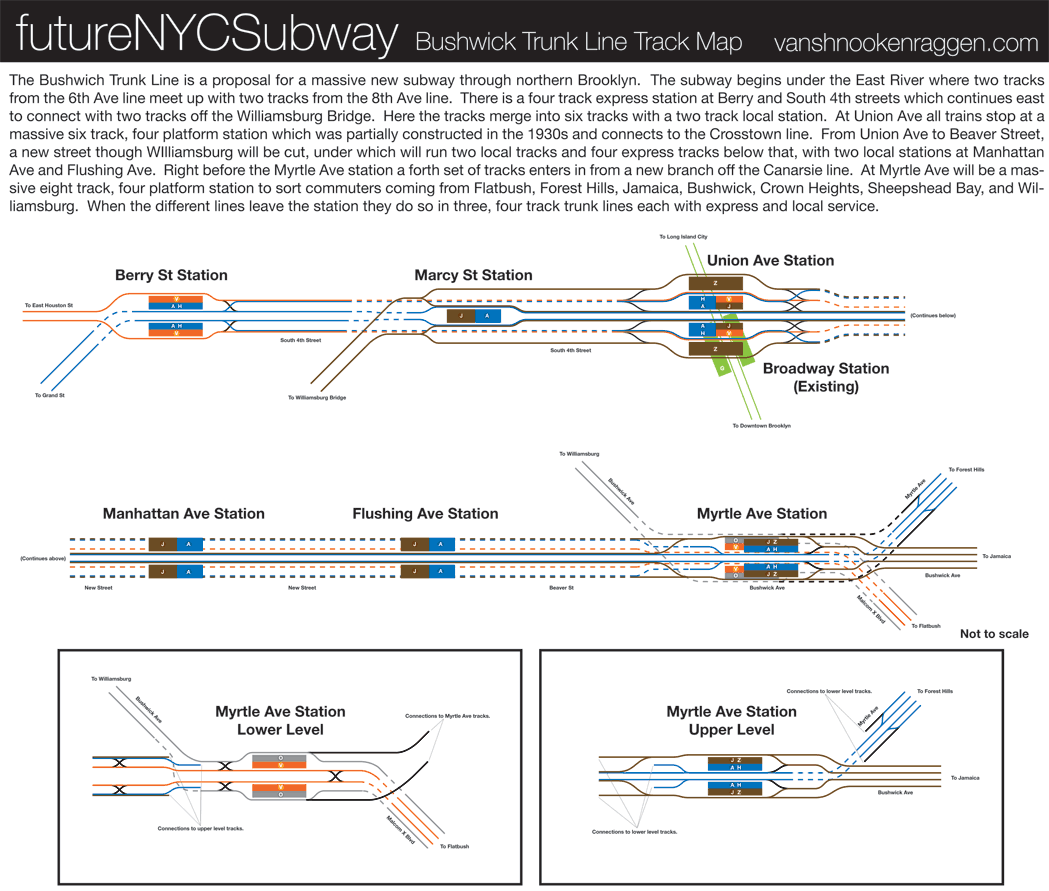
East of Union Ave the Trunk Line would run north of and parallel to Broadway which would require cutting a new street from South 4th/Union Ave to Beaver St/Flushing Ave. A routing along Broadway would necessitate the demolition of the elevated train before new service would be built to replace it. The city has a very poor track record of replacing elevated trains with subway service which is why the more expensive option of cutting a new street would be the better one.
The purpose of the Bushwick Trunk Line is to allow for modern subways to service outlying areas of the city, bring them together to sort passengers, and transport them out into different areas of Manhattan (and downtown Brooklyn). The different subways coming together in the Trunk Line are the Myrtle Ave Subway/Union Turnpike Subway (with a branch of the Crosstown Line), the Utica Ave Subway (with connections to the Canarsie Line), and the replacement subway for the demolished Jamaica Line elevated tracks. The Trunk Line would have 2 local tracks and 4 express tracks which would be below the local tracks.
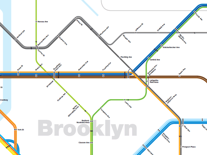
6 tracks running from South 4th St under the new street would merge again with a new branch of the 14th St-Canarsie Line. This branch would break off the Canarsie Line after Montrose St and continue south under Bushwick Ave. This merger would occur right before a massive new transfer station at Myrtle St/Bushwick Ave. This station would be very similar to the West 4th St station with two sets of 4 track platforms separated by a mezzanine. 8 tracks would enter the station, 12 tracks would leave the station; 4 tracks for each branch line. To wrap your head around what I’m proposing here I’ve created a track map. A track map shows each track as a thin line. Here I have color coded each set of tracks to show which trains would run where. Platforms are the solid rectangles. Dashed lines indicate when a track runs below another track (3rd dimension).
After Myrtle Ave the different subways would branch off but a 4 track subway would continue east under Bushwick Ave to replace the Jamaica Line elevated. The new subway would go as far as the train yards at Broadway Junction where the tracks would rise to the surface and continue along the existing elevated structure. In a later post I will address what can be done about the existing elevated line.
Myrtle Ave Subway and Crosstown Subway Connection
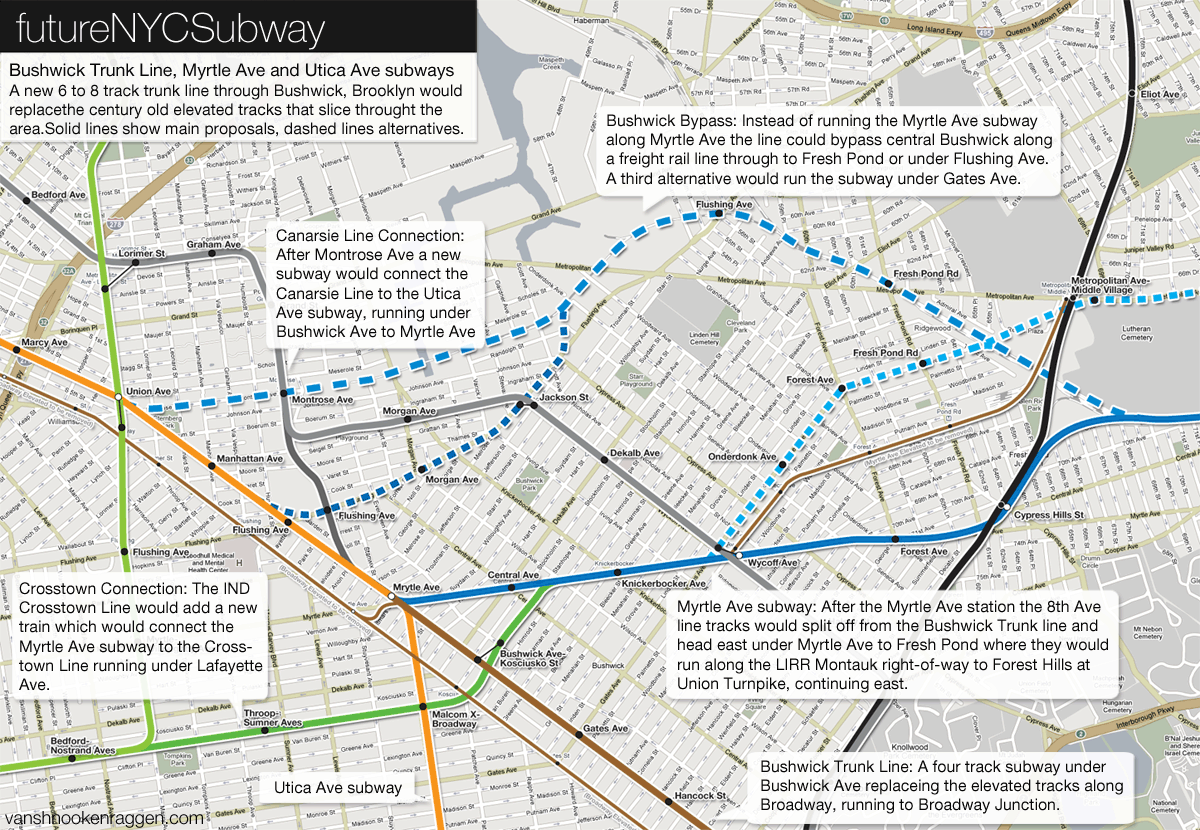
The Mrytle Ave Subway would be the first branch off the Trunk Line and would be a replacement for the elevated train currently along Myrtle Ave through Bushwick and Ridgewood. The Myrtle Ave Subway would split off the Bushwick Trunk Line after the Myrtle Ave station and travel northeast under Myrtle Ave to Fresh Pond Rd where it would rise to the surface, run at grade, to travel along side the Long Island Railroad Montauk Branch tracks. At this point there would also be a separate track system to connect the new subway to the existing Fresh Pond train yards. The subway would be 4 tracks serving 8th Ave trains.
A number of alternatives are available. The first would utilize an old freight rail line which terminates at Bushwick Place and Montrose Ave. This line once ran passenger trains from Williamsburg to Coney Island and Long Island but cut this service in the 1920s. The first alternative would have a subway branch off the Bushwick Trunk Line right after the Union Ave station running under Montrose Ave and rising to the surface to run at grade somewhere after Varick Ave along this stretch of track. The line would follow the freight tracks until Flushing Ave where they would run along side the LIRR Montauk Branch tracks, continuing east. A second alignment in this would run the subway under Flushing Ave for a while before connecting with the LIRR Montauk Branch. This second alignment would be more costly than the freight track alignment but would have the benefit of closer to residential areas.
A downside to the Myrtle Ave Subway alignment is that it runs south of the current elevated subway through Ridgewood. An alternative that would address this would run the subway up Gates Ave to the point where it meets the LIRR Montauk Branch tracks. This alignment would serve more people as it runs through the heart of the neighborhood and would also run close by the Fresh Pond train yards but a major downside would be very disruptive construction along residential streets.
Though the Myrtle Ave Subway would mainly branch off of the Bushwick Trunk Line I also call for a new subway which would branch off the IND Crosstown Line after the Bedford-Nostrand Aves station. A commuter using said station will note that there are in fact 3 tracks with 2 island platform, strange since the Crosstown Line has only local service and runs with 2 tracks for the rest of its length (see pictures at NYCSubway.org). There are two thoughts to why this extra track exists, the first being that it was designed to be a terminal station for service changes, and second that it was designed to be a junction station where two subway lines would combine. The middle track at Bedford-Nostrand continues east while the outside tracks curve to the north. The third track then splits into 2 tracks but dead ends (which could be used for layups of trains of extending service east). This dead end is where we start, continuing the subway along Lafayette Ave to Broadway where it would curve northeast under Kossuth Pl and Stanhope St, connecting with the Myrtle Ave Subway before Knickerbocker Ave.
This additional tunnel would allow service from central Queens three options of service: an express into Manhattan, a local into Manhattan (both of which would allow for easy transfers to uptown or downtown trains) and a local to downtown Brooklyn. The new Crosstown Line Connection would also finally repair the connection between northern Brooklyn and downtown Brooklyn which was severed when the Myrtle Ave elevated was taken down in the 1960s.
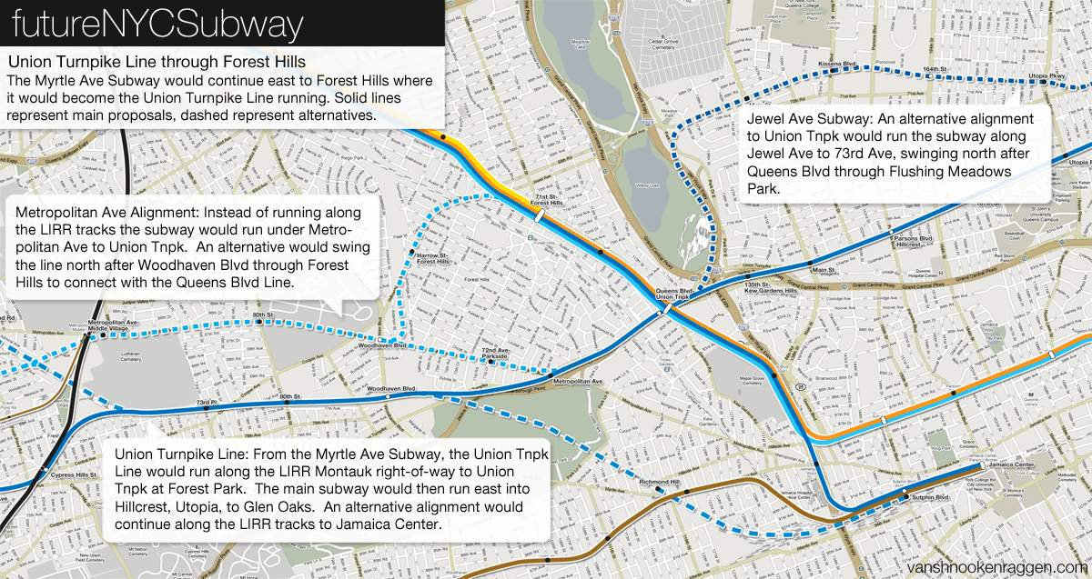
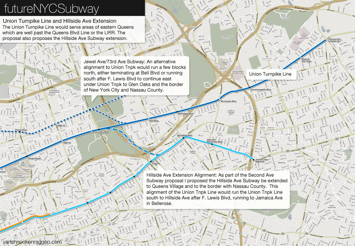
The Myrtle Ave Subway would continue east into Queens through Glendale along the LIRR Montauk Branch tracks to Forest Hills. After Woodhaven Blvd the subway would run under Union Turnpike. The Union Turnpike Subway would continue east under Union Turnpike to the Nassau County border. This 4 track subway line with three trains would be the first to open up a large section of central Queens to new subway service into downtown Manhattan and Brooklyn. The subway would intersect the Queens Blvd Line so commuters would be able to switch to express trains to Long Island City and midtown Manhattan. At Queens Blvd/Union Turnpike there would be a connection between the tracks of the two subway lines which would enable trains from the Union Turnpike Subway to access the existing train yards just north of Union Turnpike, the Jamaica Yards.
An alternative alignment would run the subway under Metropolitan Ave through Middle Village. This alignment would run closer to residential areas but would also be much more expensive than a subway running at grade along the LIRR tracks. The Metropolitan Ave alignment would, however, allow for an alternative western alignment of the new subway which would swing up and around Forest Hills to merge with the Queens Blvd Subway (as opposed to running south of Forest Hills.) This alternative alignment would be a good option if funding comes up short which would prevent the subway from just ending in the middle of nowhere (Please note that I am not saying that Forest Hills is the middle of nowhere.)
(Side Note: In these and future posts I include in each proposal from all previous expansion plans so that they build on one another. As such in each of these maps here you can see my plans for Second Ave Subway extensions into Queens. For explanations of these extensions see the Second Ave Subway post.)
After Forest Hills the Union Turnpike Subway would run one of two ways: the first would be straight down Union Turnpike to the Nassau County border, and the second would be a more northernly route under Jewel Ave. This second alignment would require a large “S” curve in the routing of the subway after Forest Hills which would run the subway at grade along the Van Wyck Expressway up to Jewel Ave where it would turn east again. With either alignment the 4 track subway would run to 188th St where the local trains would terminate and the express trains would take over. The subway past 188th St could either run in a 2 track or a 3 track tunnel to allow peak period express trips (much like the IND Grand Concourse B/D Subway does today). An alternative to running the subway out to Glen Oaks would have the line jog south at the Clearview Expressway to connect with an extended Hillside Ave subway to Queens Village and Bellerose.
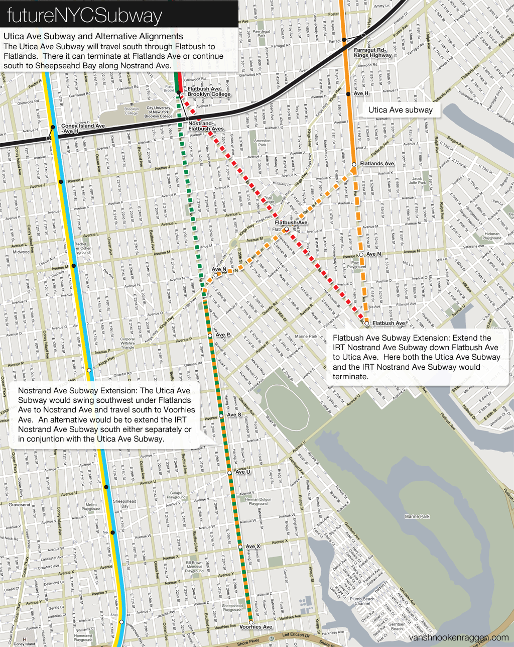
The Utica Ave Subway comes from the original IND Second System expansion plans from the 1920s and 30s. This area of Brooklyn was still largely undeveloped at that time and the subway would most likely have been built as an elevated structure to save money. After the neighborhoods of Flatlands, Sheepshead Bay, and Gerritsen developed after World War II it became too unpopular to build an elevated structure but too costly to justify a subway even though the demand was higher than ever. A subway under Utica Ave still remains in transit planners minds as ideas have been proposed for long term expansion during the last 50 years that involve a scaled back subway branching off the IRT Eastern Parkway 3/4 Line or the IRT Nostrand Ave 2/5 Line.
My updated proposal keeps true to the original with a slight difference. In the original proposal the Utica Ave Subway would branch off the Bushwick Trunk Line after Myrtle Ave and travel down Stuyvesant Ave to Fulton St. At the Utica Ave station on the Fulton St Subway there is a 4 track express shell station which was constructed in anticipation of the Utica Ave Subway. My proposal runs the subway a block east under Malcom X Blvd/Reid Ave to avoid demolition of a school building. From there the subway would run straight south down Utica Ave to Flatlands Ave. Here the subway could take a number of different routes. The first would be to keep running south to Flatbush Ave. Another would be to turn southwest under Flatlands Ave and run to Nostrand Ave where it would continue south along Nostrand Ave to Voorhies Ave. Both of these options were proposed during the 1920s and 30s plans.
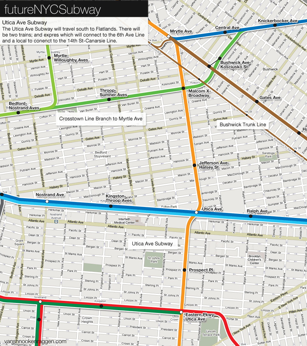
On major difference between the original plans and my plans are that I call for a connection between the 14th St-Canarsie Line and the Utica Ave Subway at Myrtle Ave (see track map above). Historical proposals all called for a 4 track subway with express and local service. However these proposals existed before the Chrystie St Connection which allowed 6th Ave trains to run into south Brooklyn. The original proposal for the Utica Ave Subway had local and express 6th Ave bound trains which is today not possible since adding a fifth service to the 6th Ave Subway would congest the line too much. This is why I propose a connection between the Canarsie Line which would run 6th Ave trains express and 14th St trains local. All trains on the Utica Ave Subway would run to midtown since there would be no less than four different points along the line where commuters would be able to transfer to express trains to downtown Manhattan (making Utica Ave trains running to downtown Manhattan quite redundant).
Then there is the extension of the IRT subway. Alternatives proposed in the past have run an IND and IRT subway parallel to each other or a combined subway. In the map to the right I explore both options. My only issue with extending the IRT subway south is that the Nostrand Ave Subway is currently only a 2 track local subway and extending the line so far south without an express train would make travel times much longer and be much costlier than just building a 4 track Utica Ave Subway with express and local service. Adding an express track to the Nostrand Ave Subway would be far too disruptive to service which at that point would make a new 4 track subway under Utica Ave justifiable.
To sum up the Bushwick Trunk Line services: 6th Ave express (restored “V” service) and 14th St-Canarsie local (a new “O” service) trains would run along Utica Ave, 8th Ave express and local trains (“A” service and a new “H” service), added by a Crosstown local train (a new “K” service), would run out along Myrtle Ave/Union Turnpike Subways, and Jamaica Line express and local trains (existing “J” and “Z” service) would continue to run out to Broadway Junction but in a new subway. All elevated structures between the Williamsburg Bridge and Broadway Junction would be demolished.
There are three major reasons why a new trunk line subway is needed for northern Brooklyn. Firstly, the existing infrastructure is old and cannot handle the foreseeable population increases. Northern Brooklyn was one of the worst hit areas of urban decay during the latter half of the 20th Century but has begun to stabilize with an influx of new residents attracted by low land prices. Secondly, any addition service to areas of Brooklyn and Queens which are today out of reach by subways need fast express capacity to ferry commuters from so far out into the central city. Current subways are either at capacity or are in no shape to be extended further out. This speaks to the failure of the city to properly plan for post World War II residential development. Had the original IND Second System proposals for a trunk line subway through northern Brooklyn been even partially completed then major parts of the city would be better accessible today.
Thirdly, there no more room for the city to spread outwards. Even with this current recession, population trends locally and globally point to increased urbanization. Brooklyn and Queens were consolidated into Greater New York City in 1898 precisely because they had space. Today, while they lack horizontal space, the average height of a building in these boroughs is still only a few stories. Highways and roads can handle only so much. New mass transit routes are needed if the city is to grow and growth in suburban areas of Brooklyn and Queens is the next logical step. As hard as it is to imagine now the skyscrapers of midtown Manhattan were once small hamlets and farms. The suburban streets of central Queens may one day be home to large apartment houses. It is very probable that there will be resistance to such growth but there will come a time when it is inevitable and the infrastructure must be put in place lest the city choke on traffic.
These subway plans are only one part of this growth. I believe that the growth can be properly planned in conjunction with expanded infrastructure. If not what will happen city wide is what has happened to Williamsburg; the transportation infrastructure has not been able to keep up with the residential growth. There is much push back now towards more development due to the lack of capacity. If the South 4th St Subway had been built 60 years ago then this would not be an issue. The city is building an extension of the IRT 7 Line to the Far West Side of Manhattan in anticipation of development, what would happen if the city built subways to where there already is major development choking current infrastructure?
The futureNYCSubway
- IND Second System
- Post War Expansion
- The Second Ave Subway: History
- The Second Ave Subway: To The Bronx and the Nassau Line
- Brooklyn: Bushwick Trunk Line
- Manhattan: West Side and Hudson Crossings
- Queens: Flushing Trunk Line
- Staten Island: The Last Frontier
- TriboroRX and Atlantic Ave Super-Express
- Conclusion: the vanshnookenraggen plan
I think the focus should really be on Utica Avenue and Nostrand Ave. They’re the second and third highest ridership bus lines in the city (after the second avenue M15), because they both obviously should have metro service but don’t.
Bushwick near the Broadway line does not need new service. The Broadway line is one of the least-used lines in the city as it is… I spose it would be demolished though if this subway were built, I’m sure that was the original intention of the 4th street line.
“A routing along Broadway would necessitate the demolition of the elevated train before new service would be built to replace it.”
This is false; cut and cover subways can and have been built under active elevated lines. The most notable case was the construction of the IND Fulton St Line, which underpinned the BMT Fulton St Elevated for most of its length, and there were other cases in Brooklyn and Manhattan. Underpinning an elevated line adds some cost, but nothing compared to the political and financial cost of acquiring by eminent domain a huge stretch of Bushwick for a new street! Even a bored tunnel would be a better option.
“these unused tracks were eventually extended south when the WTC was constructed to handle the additional crowds.”
Also incorrect; the 8th Avenue local tracks have terminated at World Trade Center (formerly known as Hudson Terminal) since the line opened in 1932, in order to provide for transfer to the Hudson and Manhattan Tubes (now PATH).
Thanks for the corrections.
You have very good proposals, but I do not think tearing down the Broadway line will be good. The elevated trestle does have good ridership and is historical.
Minor note about the B46: it actually overtook the M15 as the busiest bus route in the system (and actually the United States). Even further exemplifying why subway service is so crucial for that area.
I would just have the E,V train run down the Utica Ave line. I would have both trains curve southeast from Flatbush Ave. The E,V would travel down Ave U and
turn east to meet up with the 2,5 at Nostrand Ave. The E,V would terminate there.
I my self wouldn’t want to tear down the Broadway el but after looking deeply at his proposal, it would benefit to tear down the old Broadway el up to Alabama ave.
Have the J train run express through Bklyn. At Broadway Junction the Z train should separate from the J line turning south on Pennsylvania ave with stops at Liberty ave, Sutter ave, Livonia ave, Linden Blvd, Flatlands ave, terminating at Seaview ave/ Starrett City.!!!
I love your proposal. I agree that the Broadway Elevated should not be torn down east of Alabama Avenue, though. Also,I have a question. What program(s) did you use to make those maps? Sorry if I am being impolite in anyway.
Thanks, glad you like them. I use Adobe Illustrator and Photoshop to make my maps.
original plan for the south fourth street subway is to have two lines each with 4 tracks one heading south towards Sheepshed Bay via Stuyvesant/utica Aves and the other to the Rockaways via Myrtle/Central Aves. unlike today’s Rockaway Line which is serve by todays A train, this 1929 rockaway line is designed to be built as a seperate right a way from the existing Rockaway which was owned previously by the LIRR. even though the LIRR Rockaway was built with a rapid transit in mind as evident in The history of the Independent Subway on the website http://www.nycsubway.org. plans for the Broadway el to be demolished when they made changes to the south fourth Street Subway.again, http://www.nycsubway.org there are a lot of proposals you haven’t seen which date back from as early as 1900s to 1970s and the present time
At first, the original plans for the South Fourth Street Subway is to have two lines with each four tracks where one would turn south towards Sheepshed Bay and the other towards the Rockaways via Myrtle/Central Avenues, 98th/99th & Hawtree Streets and Rockaway Boulevard. Unlike todays existing Rockaway Line, This was design and built as a seperate right a way from the LIRR Rockaway Line but with a similar pattern, even though the LIRR Rockaway Line was build with a rapid transit service in mind as evidence in the History of the Independent Subway at http://www.nycsubway.org. The Rockaway would have connections as well from Queens Blvd line and an elevated line serving parts of southeast of Queens. The change was made between 1929 and 1939 as the original plans wouldn’t do much for relieving or tearing down the existing els except for the Myrtle Avenue el. evidence in list of abandoned stations in the JoeKorNor website at nycsubway.org. You have to look for the world of subways, then the metro north grand central section where you’ll spot a list of abandoned stations highlighted. For there, you see a catagorie of abandoned and unfinished proportion of subways and click on the unfinished IND second system and go to the bottom and you’ll see JoeKorNor website higlighted in blue. It shows an explanation of the changes in the South 4th Street subway and there are a least two plans in comparison to the original. Other than that,in your bushwish truck line, you have at least two line that share a similar pattern. The Stuyvesant/Utica Vevenue line and a 4 track line under Broadway.
I also think its impossible to build a subway that would replace the Jamaica el without building another subway that would come off the Archer Avenue Subway lower level near Sutphin Blvd and rejoin the same line again at between Bowery and Canal Street on the Nassau Street Line while the new subway feeds under Metropolitan Avenue in Queens & Brooklyn and E 6th Street & Bowery Street in Manhattan. I got the idea from one of Chicago’s possible future plans which includes having a new subway coming off the red line and rejoin the same line at different locations. I came up with it because it would increase the amount of trains running during rush hours than the ones on the el. It would make it possible to build a subway under bushwick avenue which requires a lot of work on the part where the line would use the portal to reach the south fourth street line. With two subway lines would double the amount of trains used during rush hour, but transit screw up the Nassau Street Line by emerging the north bound track onto the southbound express track, making it difficult to build a new subway
instead of build the subway under myrtle avenue you can build it under flushing avenue and then metropolitan avenue it can still continue northeastern toward lakeville rd via union turnpike. you can also split two routes: one along flushing to marathon pkwy via LIE and another along metropolitan avenue to jamaica avenue where it can continue to little neck parkway and you can transfer to the hillside avenue subway.
that last comment that I made was an alternative to avoid taking out the broadway and the myrtle el as the J,M and the Z have a line to provide servive as the new lines act as a backbone for these existing lines.
Was thinking, maybe in order to connect the 8th Ave E train to Williamsburg, have the E continue South past WTC, but loop it back up and merge into the BMT line going north using the underutilized tracks and platforms, then have it continue the shirt distance of new tunneling, either Cut & Cover or TBM to merge into the IND 6th Ave Subways new tunnel should still continue east along Houston St across the East River to South 4th St in Williamsburg. This would greatly improve utilization of assets that are already there and keep cost low. Please respond to give me your thoughts. E Train to J/Z to 6th Av to South St. Thanks.
I have to agree with Anon, subway can be built under the same road even if the elevated routes are still there but, that is one of the ways to build subways without replacing elevated lines. Jerome Avenue, New Utrecht Avenue and McDonald Avenue would have been examples of having an elevated and a subway along the same road