Archive for May, 2010

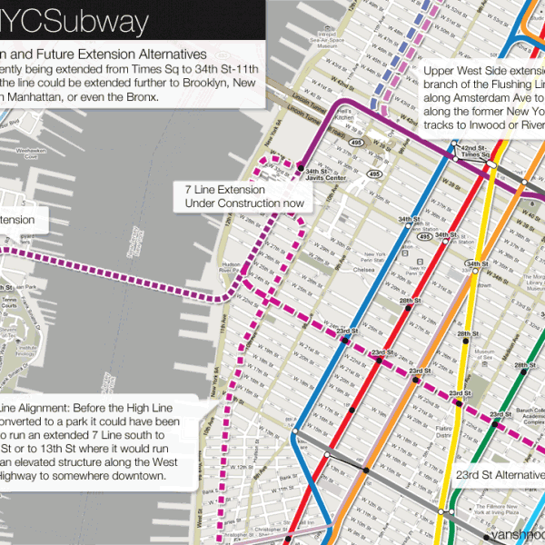
The futureNYCSubway: Manhattan’s West Side

Wednesday, May 19th, 2010

Introduction

Elevated Train, 9th Ave, 1940 by Andreas Feininger

Elevated Train, 9th Ave, 1940 by Andreas Feininger

Manhattan is the only borough of New York City where major subway expansion is actually taking place. The Second Ave Subway and the 7 Line extension are the first major subway expansion projects in almost 40 years. I’ve covered both in previous posts so I want to look further into what might be possible for expanded service in Manhattan. The areas along the west side of the island are still far away from subway service (elevated trains once rumbled up 9th Ave but were replaced in the 1930s by the 8th Ave Subway). The 7 Line extension, as it is currently being built, will not include a station at 10th Ave/41st St which will mean that trains will bypass a large residential section of town, Hells Kitchen and Clinton, in order to serve a neighborhood which is not even built yet, the Far West Side and Hudson Yards.

While over on the west side let’s look across the Hudson River and realize that there are many commuters who pour into New York from New Jersey every day through the Lincoln and Holland Tunnels and over the George Washington Bridge, the most heavily trafficked bridge in the world. There are also rail connection between New York and New Jersey via the PATH system and New Jersey Transit into Penn Station. Construction of a new 2 track tube under the river from New Jersey to Penn Station has recently begun which will double capacity along the Northeast Corridor (check out the ARC Tunnel). The PATH system went through an identity change in the 1970s when the Port Authority of New York and New Jersey took over the defunct Hudson & Manhattan Railroad which was built to shuttle passengers from various train terminals in Hoboken and Jersey City into downtown and midtown Manhattan. As service grows between the two states and as capacity along the automobile lanes is stretched to capacity, new rail connections seem inevitable.

Another inevitability is that Manhattan will need a new crosstown subway line soon. Planners have seen this as an issue for over 70 years as crosstown subways have been proposed from 57th St to 23rd St. Any new subway lines into Queens will have to enter Manhattan at some point and even with a completed Second Ave Subway there will be little extra capacity on existing East River tunnels. A new crosstown subway in midtown Manhattan would be ideal for adding the additional capacity needed and could be extended out into Queens.

Flushing Line 7 Train Extensions

7 Line extensions into the Far West Side of Manhattan.

7 Line extensions into the Far West Side of Manhattan.

Currently under construction from 8th Ave/41st St to 11th Ave/34th St with layup tracks extending south to 11th Ave/25th St, I covered the history of the 7 Line extension in a previous post. Now I want to look at some past proposals for extension and some future possibilities.

  • High Line and West Side Highway

    Before the High Line was a park it was just another abandoned railroad line though a major city which most people didn’t even know about (you can see my pictures from before the park was built on my“A Walk on the High Line” post). In the 1980s and 90s when the West Side Highway was being torn down and replaced by the Hudson River Park and a landscaped boulevard, many transit advocates called for using this opportunity to build a new transit line along the west side to the World Trade Center. A transit option had been proposed as an alternative to the plans for the Westway, a massive highway tunnel system along the Hudson River to replace the decaying West Side Highway. When the Westway was killed in 1985 it was hoped that the new replacement would have space from transit of some kind, be it a subway, elevated rail, or bus lanes.

    The proposal to extend the 7 Line south along the west side would have brought the 7 Line west from Times Sq down to the Hudson Yards where it would have connected to the High Line at the point where the High Line tracks enter the ground along 34th St at 11th Ave. From here the 7 Line would have looped around the train yards and made its way through the middle of the block along the High Line. Since the High Line was built only for freight trains it never had stations (though each building through which it ran did have loading platforms for freight). New stations would have meant that many warehouses and residential buildings would have needed to be demolished. The High Line had originally run south to West Houston St where it terminated in a large meat packing facility. The portion of the High Line from Gansevoort St to West Houston St was demolished in the 1990s for new housing development. Had this section not been removed then it could have been extended along an elevated structure from West Houston south along the West Side Highway to a new terminal at the World Trade Center.

    History has written a different story. Though the West Side Highway was replaced by a landscaped boulevard and park system, no space for transit was made available. The High Line was in danger of being demolished entirely but was saved by creative community activists and a new mayor.

    Please note: I am not in favor of replacing the High Line Park with active rail transit. This was merely an historical proposal.

  • 23rd St Crosstown
    7 Line extension into Hoboken and Jersey City.

    7 Line extension into Hoboken and Jersey City.

    The current extension of the 7 Line will end at West 25th St at 11th Ave. Since 11th Ave starts/ends at West 22nd St there are only two options for where the line could be extended from here.

    The first option would be to turn the line back east at 23rd St and create a new crosstown subway. Crossing the East River at 23rd St the line would be pointing directly to Greenpoint, Brooklyn. The 7 Line could possibly be extended southeast into North Brooklyn or could be sent northeasterly back into the southern tip of Long Island City to connect back with the 7 Line to Flushing thereby creating a large loop through midtown Manhattan.

  • Hoboken and Jersey City

    The second option for extending the 7 Line past 25th St would be to send it west under the Hudson River into Hoboken, New Jersey. There are jurisdictional and bureaucratic issues with building anything across the Hudson River since it is a state boundary. The Port Authority was set up to build and maintain all interstate crossings inside a 25 mile radius area from the Statue of Liberty. Knowing this it is easy to understand why the New York City Subway has never crossed the Hudson River, but this does not mean the need does still not exist.

    The subway extension would leave Manhattan at 23rd St and head straight across the river to Hoboken at 12th St. The subway would curve south at Main St and head down to the Hoboken Terminal. Here there would be a transfer point for the PATH, Hudson-Bergen Light Rail, and New Jersey Transit. After Hoboken Terminal the subway would run parallel to the PATH down to Pavonia/Newport station, then down to 6th St where it would turn west. Jersey City was once covered in train tracks as it was the eastern most place trains could travel before they hit the mighty Hudson River. Jersey City was the home of many terminal buildings which allowed people and freight to transfer to barges headed to Manhattan. Because of this there are more than a few ruins left over from the railroad days. Like the High Line, Jersey City has a large abandoned railroad embankment running through the old residential neighborhood between 6th and 5th St. The 7 Line subway would ascend to the surface along 6th St here and run elevated along the embankment. The right-of-way leads directly to Journal Sq which is where the 7 Line extension would terminate, along side the PATH station.

  • Union City and the Upper West Side
    7 Line extension into Clinton, Union City, and the Upper West Side.

    7 Line extension into Clinton, Union City, and the Upper West Side.

    Back in Manhattan, instead of continuing the existing 7 Line south, an alternative would be to turn the 7 Line north into the Clinton/Hells Kitchen neighborhood along 10th Ave. On 10th Ave the 7 Line would run north to 72nd St where it would merge with the existing 7th Ave Subway at Broadway. From here north the 7 train would run along side the 1 train as a local service up to the Bronx. 10th Ave is interesting in this case since just west of 10th Ave, running through the block, is the depressed Amtrak right-of-way built at the same time as the High Line. This below grade rail line runs up the west side of Manhattan under Riverside Park and by Inwood before skirting the coast of the Hudson River up to Albany. This would allow for the 7 Line to act as a super-express subway for the west side of Manhattan up to Inwood. An actual current proposal for a similar transit expansion would have MetroNorth trains use this right-of-way with stations at 66th St, 125th St, and Dyckman St. MetroNorth trains would require no new tracks like a subway would so this is a much preferable and economical option.

    Alternatively the 7 Line could jump the Hudson River at 55th St and head into Union City, New Jersey. There is currently a train tunnel through the high cliffs on top of which Union City is built. The tunnel is currently being used for the Hudson-Bergen Light Rail. If these tracks were converted to subway service the 7 Line would have a ready to use tunnel into New Jersey. At the portal to the tunnel there could be built a large park and ride station which would attract commuters who might normally drive into Manhattan.

10th Ave and Crosstown Subways

10th Ave Subway and Crosstown alternatives.

10th Ave Subway and Crosstown alternatives.

As I stated above planners have seen the need for new crosstown subways for decades. In the 1960s an underground people-mover system was envisioned that would connect Grand Central Terminal with Rockefeller Center. Because the Midtown Central Business District (CBD) is so important to the economy of the region it is crucial that it is served well by transit. Since there is no more room for cars in this dense area the best option at the moment is mass transit. Currently there are crosstown subway lines at 59th St (N/Q/R trains), 53rd St (E), and 42nd St (7/Shuttle).

A new, 2 track, crosstown subway would serve an additional purpose, that of new capacity. Even if the 2nd Ave Subway is fully built out there will new capacity on existing lines in Manhattan but no new capacity in Queens. In my next post I will talk more about new subways in Queens but for these to be possible they need a place to go. A new crosstown subway in midtown Manhattan would be the perfect connection for a new subway to Queens. The 63rd St tunnel was built for this very reason but due to lack of funding no new capacity was constructed in Queens and the current 63rd St tunnel is operating under capacity because of this (read more about the history of the 63rd St tunnel here.)

The two best options for a new crosstown subway would be at 57th St or at 50th St. The 57th St alignment would connect with Columbus Circle, major express subway stations, and the hotel areas above midtown but the 50th St alignment would directly serve the CBD and still connect with major subway lines. A benefit to the 50th St alignment would be that an underground pedestrian mall could be constructed and connected into the existing concourse at Rockefeller Center. An underground concourse connecting Times Sq, the Midtown CBD, and Grand Central Terminal would reduce pedestrian traffic on the streets and allow for substantial retail which could help pay for the subway.

A cheaper alignment may be along 53rd St where the existing IND subway runs. The problem with this alternative is while the tunnel segment from 8th Ave to 6th Ave is 4 tracks, the tunnel from 6th Ave to the East River is only 2 tracks. Queens bound trains would have to be cut back to allow for an additional train, though an additional crosstown train at 53rd St would have the benefit of being able to directly connect to the 8th Ave Subway and add additional express service along the west side of Manhattan to downtown.

Crosstown subways from midtown Manhattan entering Long Island City.

Crosstown subways from midtown Manhattan entering Long Island City.

Where ever the crosstown subway is built it will have end up somewhere. Like the existing 14th St-Canarsie Line it could terminate at 8th Ave but because there is a large residential neighborhood just west of 8th Ave (Hells Kitchen/Clinton) it would make more sense to extend the subway over to 10th Ave and run it south to 14th St to connect with the 14th St-Canarsie Line. This would mean trains could enter from Brooklyn and unload passengers heading south, then swing north to serve the proposed Hudson Yards development and the Hells Kitchen neighborhood, then turn back east into midtown and on into Queens. Due to the commuting habits at rush hour it is foreseeable that there would be three different trains running on this subway: an all local train running from Brooklyn to Queens via 10th Ave, a Brooklyn only train at 14th St which would terminate at 10th Ave, and a Queens only train at 50th St (or another alignment) which would also terminate at 10th Ave. Off peak hours could run one or two all local trains from Brooklyn to Queens.

On the Queens side of the East River the new 10th Ave-Crosstown subway would need a place to enter Long Island City, a growing mixed use neighborhood. This fact has more to do with affecting the location of the new subway in Manhattan than anything else. Because existing subways in Long Island City are at capacity a new 4 track subway would need to be built. Currently the IND Crosstown G Line is cut back to Court Sq instead of connecting to the Queens Blvd Line and running to Forest Hills. Because of the ridership demand for midtown Manhattan service G train riders must transfer to the E/M trains to get to Queens Plaza. A new tunnel under the East River servicing a 10th Ave-Crosstown train would allow for the G train to finally get a proper terminal.

Depending on the alignment, a new 2 track tunnel under the East River would enter Long Island City and head towards Queens Plaza. A more southern alignment, like the one at 50th St, would meet up with the IND Crosstown G Line before Court Sq, thereby allowing a new tunnel and station to be built which would combine the two subways into a 4 track trunk line built parallel to the Queens Blvd Line to Queens Plaza. The new subway would be built inside the Sunnyside Rail Yards so no buildings would need to be demolished for this expansion to take place. A new 4 track terminal station would be built adjacent to the existing Queens Plaza station for transfers.

Morningside Ave Line

Proposals for a super-express subway to Morningside Heights.

Proposals for a super-express subway to Morningside Heights.

One of the more peculiar proposed subway lines from the original IND Second System was for a super-express subway under the west side of Central Park to Morningside Heights that would terminate at 145th St. The subway would have only had stations from 110th St to 145th St and would have connected with the BMT Broadway Line at 57th St. Early BMT subway maps actually show a small stud aimed this way at 57th St. While a new subway line through the Upper West Side was very much needed around this time, the peculiar thing is that this subway was still being proposed well after the 8th Ave Line opened, serving this same are.

My theory, and I have nothing to base this on, was that a Morningside Ave super-express subway was planned to compliment a pair of super-express tracks which were planned for the 2nd Ave Subway. Originally the 2nd Ave Subway was planned with 6 tracks through the Upper East Side, 2 local, 2 express, and 2 super-express with no stops until the line reached the Bronx. The subways through the Upper West Side were older, the original NYC Subway ran up Broadway, had two express stations at 72nd and 96th Sts, and only a third track for rush hour express trains after 103rd St. The areas around Morningside Heights, meanwhile, were rapidly developing at this time because of the improved transportation the new subways were bringing; in a sense the subways were too popular too handle the growing demand. A super-express subway would have taken considerable stress/directly competed with the IRT (keep in mind that the subways were still operated by three different companies at this time).

Today the shortcomings of the early subway designs are as evident as ever (for instance there is no express station at 125th St at Broadway). Already I’ve suggested three options for a super-express subway through the Upper West Side: a 7 Line extension along the Amtrak Hudson River tracks, a MetroNorth alternative along the same way, and a subway up Amsterdam Ave which would be an extension of the 14th St-Canarsie Line up 10th Ave.

Let’s add the original proposal into the mix, a branch off the BMT Broadway Line along Central Park. This would be the least disruptive option of them all since it would only require digging through the park. At the north end of the park the subway could swing west, like originally proposed, and run under Morningside Ave and Convent Ave to 145th St. Here the subway could terminate or merge with the IND 8th Ave Line and add super-express service directly to the IND Grand Concourse (B/D) Line in the Bronx. Alternatively, the subway could run under Lenox Ave in Harlem to 148th St (the IRT 7th Ave 3 train terminal) or connect to the IND Grand Concourse Line at Yankee Stadium.

George Washington Bridge Subway

George Washington Bridge with subway connection.

George Washington Bridge with subway connection.

The George Washington Bridge (GWB) is notable for many reasons, but one that is almost never mentioned is that it was the first major bridge built in New York City which was not built with a mass transit connection. The Brooklyn (1883), Williamsburg (1903), Queensboro/59th St (1909), and Manhattan (1909) bridges all were built with some form of mass transit but the GWB (1931), completed almost 30 years after the Manhattan Bridge, did not. What has been noted many times was that it was overbuilt (the original design called for a skin of brick and granite) and space was left over for a second deck which would have allowed for mass transit. A second deck was added in the 1960s but no mass transit option was built, not even a bus lane which could have served the busy bus terminal on the Manhattan side of the bridge. Because the bridge spans the Hudson River the bridge is owned and operated by the Port Authority of New York and New Jersey there are legal, jurisdictional, and bureaucratic issues that need to be dealt with if mass transit is to be a reality on the GWB.

There are two ways that mass transit could operate on the GWB, both of which would require the removal of a travel lane in each direction. This may seem counter productive since the GWB is the most heavily trafficed bridge in the world but mass transit would only cut down on the amount of space for cars; many more people could cross the bridge if mass transit was added.

  • Bus Lanes

    A bus-only lane along the top deck would better serve the bus terminal on the Manhattan side. The GWB Bus Terminal is a strategic part of the region’s transportation network which diverts traffic away from the main Port Authority Bus Terminal at 42nd St. A bus-only lane would also allow charter buses, which would normally cross along at one of the tunnels further south, a quicker way into Manhattan.

  • Subway

    An extension of the IND 8th Ave Line from 168th St (the current terminus for 8th Ave local trains) across the lower deck of the bridge to a new transportation facility/relocated bus terminal in Fort Lee, NJ. There exists, underground, a train yard under Broadway at 174th St to serve 8th Ave trains. The tracks connecting the yard to the 8th Ave Subway could be extended up Broadway a few blocks and curved west to run along the lower deck of the bridge (see map). On the New Jersey side a large new bus terminal and park-and-ride facility would be built where commuters would transfer to express trains to Manhattan. The facility would be built above the existing highway when space is freed up from the removal of the tool booth plazas (which would be replaced by automated license plate readers currently being installed on other bridges). The air-rights on the New Jersey side and the air-rights from the removal of the existing GWB Bus Terminal in Manhattan would be a way to finance the subway.

Conclusion

The unfortunate fact about all the subway expansion going on in New York City right now is that when it is all finished the Far West Side, Clinton, and Hells Kitchen neighborhoods won’t be that much better off. New subway connections which would extend existing lines through these neighborhoods are needed when the planned developments (and current developments along W42nd St) start to bring thousands more people into this area. This being the case it only makes sense to look at these transportation needs in a broader context. Subways in Manhattan are already close to (and in some places surpassing) their designed capacity. If other boroughs of the city are to grow (an additional 1 million people are expected to move into the city within the next 20 years) they will need a way to get around. New subways are the only desirable answer.

I’ve talked about new crosstown connections into Queens and in my next post I will discuss just where those new subways will lead to: the Flushing Trunk Line.

Subway Diagram

Subway diagram showing 10th Ave Subway, 7 Line to Hoboken, Bushwick Trunk Line, and Second Ave Subway systems.

Subway diagram showing 10th Ave Subway, 7 Line to Hoboken, Bushwick Trunk Line, and Second Ave Subway systems.


The futureNYCSubway

  1. Introduction
  2. IND Second System
  3. Post War Expansion
  4. The Second Ave Subway: History
  5. The Second Ave Subway: To The Bronx and the Nassau Line
  6. Brooklyn: Bushwick Trunk Line
  7. Manhattan: West Side and Hudson Crossings
  8. Queens: Flushing Trunk Line
  9. Staten Island: The Last Frontier
  10. TriboroRX and Atlantic Ave Super-Express
  11. Conclusion: the vanshnookenraggen plan

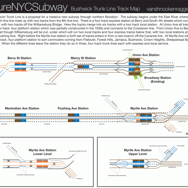
The futureNYCSubway: Bushwick Trunk Line

Monday, May 3rd, 2010

Introduction

1924 BMT dual contracts map

1924 BMT map showing existing elevated lines (in black) and proposed subways.

Because of how and when Brooklyn developed in the 19th Century it has today one of the most extensive subway and elevated rail networks in the entire nation, and it is only one borough of the city. So many lines criss-crossed Brooklyn back in the day that, unlike many other cities who’ve expanded service over the last century, Brooklyn has actually lost miles of tracks due to the dismantling of elevated lines through Bedford-Stuyvesant and Borough Park. Still, Brooklyn remains one of the most well served areas in the nation in terms of subway lines. However, there are still major sections of Brooklyn that developed after World War II and outside the range of subway service.

The city foresaw this development and planned to build subways to Flatbush, Flatlands, and Sheepshead Bay but was stopped by the Great Depression and changing priorities (e.g. the car). When the Independent subway released its grand expansion plan in 1929 it included a major trunk line though northern Brooklyn that branched out to reach the Rockaways and Sheepshead Bay. The lines connected to the 6th Ave and 8th Ave Subways had at one time up to 8 tracks servicing four different subways branching off into Brooklyn and Queens.

Much has changed in northern Brooklyn since those days. Back then there were three major elevated lines in northern Brooklyn; the Jamaica Line elevated which still runs today (J/Z trains), the Myrtle Ave elevated which once ran all the way from dowtown Brooklyn to Metropolitan Ave but was cut back to Broadway in the 1950s (M train), and the long gone Lexington Ave elevated line which ran through Bedford-Stuyvesant along Lexington Ave and was also torn down. Many of the neighborhoods of northern Brooklyn suffered severe population drains after World War II. Much of the industry left and by the 1980s the area became one of the poorest in the nation.

It is amazing then how far we have come within a generation. Due to the low cost of real estate and the availability of large loft warehouses, Williamsbug has gone from a no-mans land to being the newest, hippest neighborhood in the city. During the 1990s due to waves of new immigration from South America, Bushwick began to stabelize. As gentrification moved east from Williamsburg areas of Bushwick and Bedford-Stuyvesant began to gentrify. Today the area’s population has grown dramatically fom 10 years ago and ridership levels on every subway station in Williamsburg, Bushwick, and northern Bedford-Stuyvesant have risen. This now presents the problem: how will the century old transit infrastructure handle this new growth?

Now I am bringing this proposal back, a new trunk line serving northern Brooklyn with branches out to Queens and southeastern Brooklyn that will replace the antiquated Broadway and Myrtle Ave elevated tracks and allow for better local service and faster commutes from the far reaches of the city. This new subway is called the Bushwick Trunk Line.

6th Ave and 8th Ave Subway Connections

1929 IND Proposal for South 4th St subway.

1929 IND Proposal for South 4th St subway.

The original proposal from the 1920s was called the South Fourth St Subway for the street under which it ran. It began in two places in Manhattan, both vestiges of the IND Second System. On the 6th Ave Line at 2nd Ave station there are 2 platforms and 4 tracks. Only the outer tracks have ever been in service with the inner tracks used, until 2010, as a terminal for the V train. The inner tracks were originally built to service trains coming from Williamsburg via a tunnel under the East River. This is the first part of the Bushwick Trunk Line proposal. The second is over on the 8th Ave Line. After Canal St station on the 8th Ave Line the express and local tracks diverge into two separate tunnels. Today the A and C trains run on to Brooklyn through on one set of tracks while the E uses the other set to terminate at World Trade Center. It is these tracks, the World Trade Center tracks, that were originally supposed to head east under Worth St. The so-called Worth St Subway made a short jog along Worth St to East Broadway and down to Grand St where it dove under the East River towards Williamsburg. Both of these tunnels, at some point in Williamsburg, would have come together to form a 4 track subway under South 4th St. There were various proposals for where this would happen and various schemes for how many trains would run. The line would have been able to handle 2 express and 2 local with branches out to the Rockaways and Sheepshead Bay.

Because my proposals encompass as vaster area then along South 4th St I’ve taken the liberty to rename the proposal the “Bushwick Trunk Line”. A trunk line is a main line of a railroad that is created by combining many different passageways that branch off at some point. For instance the Lexington Ave Subway is a trunk line because it combines the 4/5/6 trains in a subway under Lexington Ave. The Bushwick Trunk Line would combine trains from central Queens, Jamaica, Flatlands, Sheepshead Bay, and Bushwick into a single massive subway and redistribute them into Manhattan.

Bushwick Trunk Line connections into Manhattan.

Bushwick Trunk Line connections into Manhattan with alternatives.

To update the original plan we have a few different options. On the 6th Ave Subway a new tunnel should still continue east along Houston St across the East River to South 4th St in Williamsburg. A station will be placed between Aves B and C to give subway access to one of the only areas of Manhattan still without close subway access. A proposal from the 1930s also brought in a connection with the Second Ave Subway which would branch off before the 2nd Ave station at Houston St and run parallel to the 6th Ave extension under Stanton St. The two subways would combine somewhere under the East River.

The 8th Ave Subway connection would be shifted south from the original proposal under Worth St to Chambers St where a new transfer facility would be constructed connecting the Lexington Ave Subwayand the Jamaica/Centre St Subway. From here the new subway would continue along the original route under East Broadway to Grand St and under the East River to connect with the 6th Ave extension to form the bulk of the Bushwick Trunk Line. Alternative alignments would have the subway running under Clinton St and merging with the 6th Ave extension before the East River or running the 8th Ave extension along Broadway in Williamsburg and connecting with the 6th Ave extension further east.

While in Williamsburg another subway connects to the Trunk Line; the Jamaica Line which today runs on an elevated track. A new portal would be constructed at the Brooklyn approach of the Williamsburg Bridge to connect the tracks on the bridge to the new subway. The elevated tracks would be torn down.

For those keeping track of the tracks, there would be two, 2 track tunnels under the East River meeting at a single 4 track station at Berry St and South 4th St. Continuing east the Jamaica Line would connect adding 2 additional tracks making 2 local tracks and 4 express tracks. These 6 tracks would run to Union Ave where at the Broadway Station on the IND Crosstown G Line is the shell of a 6 track station which was built in anticipation of the South 4th St Subway.

If you think about this in transportation planning terms then the Crosstown Line suddenly becomes a lot more useful. There is very little traffic between downtown Brooklyn and Long Island City but this was not supposed to be the case. The South 4th St subway was meant to meet with the Crosstown Line between downtown Brooklyn and Long Island City which would have added much more traffic to the line, distributing commuters more efficiently and taking pressure off transfer points in Manhattan.

Bushwick Trunk Line

Bushwick Trunk Line track map.

Bushwick Trunk Line track map.

East of Union Ave the Trunk Line would run north of and parallel to Broadway which would require cutting a new street from South 4th/Union Ave to Beaver St/Flushing Ave. A routing along Broadway would necessitate the demolition of the elevated train before new service would be built to replace it. The city has a very poor track record of replacing elevated trains with subway service which is why the more expensive option of cutting a new street would be the better one.

The purpose of the Bushwick Trunk Line is to allow for modern subways to service outlying areas of the city, bring them together to sort passengers, and transport them out into different areas of Manhattan (and downtown Brooklyn). The different subways coming together in the Trunk Line are the Myrtle Ave Subway/Union Turnpike Subway (with a branch of the Crosstown Line), the Utica Ave Subway (with connections to the Canarsie Line), and the replacement subway for the demolished Jamaica Line elevated tracks. The Trunk Line would have 2 local tracks and 4 express tracks which would be below the local tracks.

6 tracks running from South 4th St under the new street would merge again with a new branch of the 14th St-Canarsie Line. This branch would break off the Canarsie Line after Montrose St and continue south under Bushwick Ave. This merger would occur right before a massive new transfer station at Myrtle St/Bushwick Ave. This station would be very similar to the West 4th St station with two sets of 4 track platforms separated by a mezzanine. 8 tracks would enter the station, 12 tracks would leave the station; 4 tracks for each branch line. To wrap your head around what I’m proposing here I’ve created a track map. A track map shows each track as a thin line. Here I have color coded each set of tracks to show which trains would run where. Platforms are the solid rectangles. Dashed lines indicate when a track runs below another track (3rd dimension).

After Myrtle Ave the different subways would branch off but a 4 track subway would continue east under Bushwick Ave to replace the Jamaica Line elevated. The new subway would go as far as the train yards at Broadway Junction where the tracks would rise to the surface and continue along the existing elevated structure. In a later post I will address what can be done about the existing elevated line.

Myrtle Ave Subway and Crosstown Subway Connection

Bushwick Trunk Line with alternative routings.

Bushwick Trunk Line with alternative routings.

The Mrytle Ave Subway would be the first branch off the Trunk Line and would be a replacement for the elevated train currently along Myrtle Ave through Bushwick and Ridgewood. The Myrtle Ave Subway would split off the Bushwick Trunk Line after the Myrtle Ave station and travel northeast under Myrtle Ave to Fresh Pond Rd where it would rise to the surface, run at grade, to travel along side the Long Island Railroad Montauk Branch tracks. At this point there would also be a separate track system to connect the new subway to the existing Fresh Pond train yards. The subway would be 4 tracks serving 8th Ave trains.

A number of alternatives are available. The first would utilize an old freight rail line which terminates at Bushwick Place and Montrose Ave. This line once ran passenger trains from Williamsburg to Coney Island and Long Island but cut this service in the 1920s. The first alternative would have a subway branch off the Bushwick Trunk Line right after the Union Ave station running under Montrose Ave and rising to the surface to run at grade somewhere after Varick Ave along this stretch of track. The line would follow the freight tracks until Flushing Ave where they would run along side the LIRR Montauk Branch tracks, continuing east. A second alignment in this would run the subway under Flushing Ave for a while before connecting with the LIRR Montauk Branch. This second alignment would be more costly than the freight track alignment but would have the benefit of closer to residential areas.

Vestigial tracks as Bedford-Nostrand.

Vestigial tracks as Bedford-Nostrand.

A downside to the Myrtle Ave Subway alignment is that it runs south of the current elevated subway through Ridgewood. An alternative that would address this would run the subway up Gates Ave to the point where it meets the LIRR Montauk Branch tracks. This alignment would serve more people as it runs through the heart of the neighborhood and would also run close by the Fresh Pond train yards but a major downside would be very disruptive construction along residential streets.

Though the Myrtle Ave Subway would mainly branch off of the Bushwick Trunk Line I also call for a new subway which would branch off the IND Crosstown Line after the Bedford-Nostrand Aves station. A commuter using said station will note that there are in fact 3 tracks with 2 island platform, strange since the Crosstown Line has only local service and runs with 2 tracks for the rest of its length (see pictures at NYCSubway.org). There are two thoughts to why this extra track exists, the first being that it was designed to be a terminal station for service changes, and second that it was designed to be a junction station where two subway lines would combine. The middle track at Bedford-Nostrand continues east while the outside tracks curve to the north. The third track then splits into 2 tracks but dead ends (which could be used for layups of trains of extending service east). This dead end is where we start, continuing the subway along Lafayette Ave to Broadway where it would curve northeast under Kossuth Pl and Stanhope St, connecting with the Myrtle Ave Subway before Knickerbocker Ave.

This additional tunnel would allow service from central Queens three options of service: an express into Manhattan, a local into Manhattan (both of which would allow for easy transfers to uptown or downtown trains) and a local to downtown Brooklyn. The new Crosstown Line Connection would also finally repair the connection between northern Brooklyn and downtown Brooklyn which was severed when the Myrtle Ave elevated was taken down in the 1960s.

Union Turnpike Subway

Union Turnpike Subway through Forest Hills.

Union Turnpike Subway through Forest Hills.

The Myrtle Ave Subway would continue east into Queens through Glendale along the LIRR Montauk Branch tracks to Forest Hills. After Woodhaven Blvd the subway would run under Union Turnpike. The Union Turnpike Subway would continue east under Union Turnpike to the Nassau County border. This 4 track subway line with three trains would be the first to open up a large section of central Queens to new subway service into downtown Manhattan and Brooklyn. The subway would intersect the Queens Blvd Line so commuters would be able to switch to express trains to Long Island City and midtown Manhattan. At Queens Blvd/Union Turnpike there would be a connection between the tracks of the two subway lines which would enable trains from the Union Turnpike Subway to access the existing train yards just north of Union Turnpike, the Jamaica Yards.

An alternative alignment would run the subway under Metropolitan Ave through Middle Village. This alignment would run closer to residential areas but would also be much more expensive than a subway running at grade along the LIRR tracks. The Metropolitan Ave alignment would, however, allow for an alternative western alignment of the new subway which would swing up and around Forest Hills to merge with the Queens Blvd Subway (as opposed to running south of Forest Hills.) This alternative alignment would be a good option if funding comes up short which would prevent the subway from just ending in the middle of nowhere (Please note that I am not saying that Forest Hills is the middle of nowhere.)

Union Turnpike Subway through Utopia and Glen Oaks.

Union Turnpike Subway through Utopia and Glen Oaks.

(Side Note: In these and future posts I include in each proposal from all previous expansion plans so that they build on one another. As such in each of these maps here you can see my plans for Second Ave Subway extensions into Queens. For explanations of these extensions see the Second Ave Subway post.)

After Forest Hills the Union Turnpike Subway would run one of two ways: the first would be straight down Union Turnpike to the Nassau County border, and the second would be a more northernly route under Jewel Ave. This second alignment would require a large “S” curve in the routing of the subway after Forest Hills which would run the subway at grade along the Van Wyck Expressway up to Jewel Ave where it would turn east again. With either alignment the 4 track subway would run to 188th St where the local trains would terminate and the express trains would take over. The subway past 188th St could either run in a 2 track or a 3 track tunnel to allow peak period express trips (much like the IND Grand Concourse B/D Subway does today). An alternative to running the subway out to Glen Oaks would have the line jog south at the Clearview Expressway to connect with an extended Hillside Ave subway to Queens Village and Bellerose.

Utica Ave Subway

Utica Ave Subway through Flatlands and Sheepshead Bay.

Utica Ave Subway through Flatlands and Sheepshead Bay.

The Utica Ave Subway comes from the original IND Second System expansion plans from the 1920s and 30s. This area of Brooklyn was still largely undeveloped at that time and the subway would most likely have been built as an elevated structure to save money. After the neighborhoods of Flatlands, Sheepshead Bay, and Gerritsen developed after World War II it became too unpopular to build an elevated structure but too costly to justify a subway even though the demand was higher than ever. A subway under Utica Ave still remains in transit planners minds as ideas have been proposed for long term expansion during the last 50 years that involve a scaled back subway branching off the IRT Eastern Parkway 3/4 Line or the IRT Nostrand Ave 2/5 Line.

My updated proposal keeps true to the original with a slight difference. In the original proposal the Utica Ave Subway would branch off the Bushwick Trunk Line after Myrtle Ave and travel down Stuyvesant Ave to Fulton St. At the Utica Ave station on the Fulton St Subway there is a 4 track express shell station which was constructed in anticipation of the Utica Ave Subway. My proposal runs the subway a block east under Malcom X Blvd/Reid Ave to avoid demolition of a school building. From there the subway would run straight south down Utica Ave to Flatlands Ave. Here the subway could take a number of different routes. The first would be to keep running south to Flatbush Ave. Another would be to turn southwest under Flatlands Ave and run to Nostrand Ave where it would continue south along Nostrand Ave to Voorhies Ave. Both of these options were proposed during the 1920s and 30s plans.

Utica Ave Subway through Bedford-Stuyvesant and Crown Heights.

Utica Ave Subway through Bedford-Stuyvesant and Crown Heights.

On major difference between the original plans and my plans are that I call for a connection between the 14th St-Canarsie Line and the Utica Ave Subway at Myrtle Ave (see track map above). Historical proposals all called for a 4 track subway with express and local service. However these proposals existed before the Chrystie St Connection which allowed 6th Ave trains to run into south Brooklyn. The original proposal for the Utica Ave Subway had local and express 6th Ave bound trains which is today not possible since adding a fifth service to the 6th Ave Subway would congest the line too much. This is why I propose a connection between the Canarsie Line which would run 6th Ave trains express and 14th St trains local. All trains on the Utica Ave Subway would run to midtown since there would be no less than four different points along the line where commuters would be able to transfer to express trains to downtown Manhattan (making Utica Ave trains running to downtown Manhattan quite redundant).

Then there is the extension of the IRT subway. Alternatives proposed in the past have run an IND and IRT subway parallel to each other or a combined subway. In the map to the right I explore both options. My only issue with extending the IRT subway south is that the Nostrand Ave Subway is currently only a 2 track local subway and extending the line so far south without an express train would make travel times much longer and be much costlier than just building a 4 track Utica Ave Subway with express and local service. Adding an express track to the Nostrand Ave Subway would be far too disruptive to service which at that point would make a new 4 track subway under Utica Ave justifiable.

Conclusion

To sum up the Bushwick Trunk Line services: 6th Ave express (restored “V” service) and 14th St-Canarsie local (a new “O” service) trains would run along Utica Ave, 8th Ave express and local trains (“A” service and a new “H” service), added by a Crosstown local train (a new “K” service), would run out along Myrtle Ave/Union Turnpike Subways, and Jamaica Line express and local trains (existing “J” and “Z” service) would continue to run out to Broadway Junction but in a new subway. All elevated structures between the Williamsburg Bridge and Broadway Junction would be demolished.

There are three major reasons why a new trunk line subway is needed for northern Brooklyn. Firstly, the existing infrastructure is old and cannot handle the foreseeable population increases. Northern Brooklyn was one of the worst hit areas of urban decay during the latter half of the 20th Century but has begun to stabilize with an influx of new residents attracted by low land prices. Secondly, any addition service to areas of Brooklyn and Queens which are today out of reach by subways need fast express capacity to ferry commuters from so far out into the central city. Current subways are either at capacity or are in no shape to be extended further out. This speaks to the failure of the city to properly plan for post World War II residential development. Had the original IND Second System proposals for a trunk line subway through northern Brooklyn been even partially completed then major parts of the city would be better accessible today.

Thirdly, there no more room for the city to spread outwards. Even with this current recession, population trends locally and globally point to increased urbanization. Brooklyn and Queens were consolidated into Greater New York City in 1898 precisely because they had space. Today, while they lack horizontal space, the average height of a building in these boroughs is still only a few stories. Highways and roads can handle only so much. New mass transit routes are needed if the city is to grow and growth in suburban areas of Brooklyn and Queens is the next logical step. As hard as it is to imagine now the skyscrapers of midtown Manhattan were once small hamlets and farms. The suburban streets of central Queens may one day be home to large apartment houses. It is very probable that there will be resistance to such growth but there will come a time when it is inevitable and the infrastructure must be put in place lest the city choke on traffic.

These subway plans are only one part of this growth. I believe that the growth can be properly planned in conjunction with expanded infrastructure. If not what will happen city wide is what has happened to Williamsburg; the transportation infrastructure has not been able to keep up with the residential growth. There is much push back now towards more development due to the lack of capacity. If the South 4th St Subway had been built 60 years ago then this would not be an issue. The city is building an extension of the IRT 7 Line to the Far West Side of Manhattan in anticipation of development, what would happen if the city built subways to where there already is major development choking current infrastructure?

Subway Diagram

Subway diagram showing Bushwick Trunk Line and Second Ave Subway systems.

Subway diagram showing Bushwick Trunk Line and Second Ave Subway systems.


The futureNYCSubway

  1. Introduction
  2. IND Second System
  3. Post War Expansion
  4. The Second Ave Subway: History
  5. The Second Ave Subway: To The Bronx and the Nassau Line
  6. Brooklyn: Bushwick Trunk Line
  7. Manhattan: West Side and Hudson Crossings
  8. Queens: Flushing Trunk Line
  9. Staten Island: The Last Frontier
  10. TriboroRX and Atlantic Ave Super-Express
  11. Conclusion: the vanshnookenraggen plan