
Introduction
Much like my futureMBTA, this project has taken me years of researching and map making to create what I feel is the best plan for any future mass transit expansion in New York City. I first started this project when I moved to NYC 4.5 years ago after finishing my furtureMBTA project. I thought it would be a cakewalk since I had so much experience already, but I discovered the NYC Subway to be a different animal.
The futureMBTA came out of my desire to visualize what Boston’s subway would look like if all the proposed expansion projects were actually completed. After I had completed that I realized that there were many other ideas not proposed that could be and that I was now in a position to envision the future of the system. My driving belief was that Boston needed a unified plan of expansion so that when funding became available it could build each part separately that would work together with the older system, but when complete would become its own system.
When I came to New York, I was pleasantly surprised to find that this thinking had been part of the mass transit planning in the city for over 80 years. Unlike Boston, New York had a long history of subway planning and expansion and a much more devoted base of subway buffs to dream about the future. One thing I’m not going to do is give such a detailed history of the NYC Subway system, as there are many great websites already established that cover this aspect thoroughly. Rather, I am just going to lay out my plans and any history to put them into context.

This is just the introduction to a series of posts I plan on writing explaining the history of subway expansion in NYC, first with an analysis of the famous IND Second System, a close look at the long history of the Second Ave Subway and my first new map of the SAS System, and finally my plans for new lines into Queens, Brooklyn, the Bronx, and Staten Island.
Those who follow the MTA closely will scoff at the ideas for such a fantastic expansion, but like with the futureMBTA, these ideas are not based on political reality, rather they are presented to stir the mind and to inspire future leaders and city officials of the possibilities. Today, the City of New York has recovered from the population drain of the late 20th Century and now boasts a larger population than ever before, with up to a million new citizens expected to move into the city in the next generation. In the past 30 years, the city has planned for a reduction of population and services. Now the city needs to plan for expansion. This will take time, and it is because of this I think that now is the right time to share my ideas and maps.
The problem with trying to lay out an entire system-wide plan for subway expansion is that the history of New York City’s subway is so complex that, in order to fully understand why certain lines go where they do, you must understand the whole history of the system. There are many many books and websites written about the subway, how it started with 2 companies and then the city built their own line, then combined into the Transit Authority in the late 40s, the creation of the MTA in 1968, the decline of the subway in the 70s and 80s, and how it has came back. There is far too much to have to write about here of the history of the system. Because of this I am going to be jumping right into the first major “future” system plan first dating from 1929, but if you would like some context then there is only one place you need to go:
This here is the single greatest website on the subject of the NYC subway anywhere on the internet. Everything you would like to know is on there in more detail than you could imagine. For my futureMBTA website I needed to write little histories of each line first but NYC isn’t Boston, there are plenty of transit nerds out there than have written at length about the subway so I’m not going to cover well worn territory.
I realize that many of the neighborhoods and streets covered in this post may not be familiar to even life-long New Yorkers. To help you follow along, if you have Google Earth you can download a version of these maps I made along with my original “New York City subways with other transit”.
- New York City subways with other transit.kml (for Google Earth)
- 1929-1939 IND Second System Proposals.kml (for Google Earth)
The Independent Subway: A Brief Introduction
For a full history of the Independent Subway, see NYC Subway.org
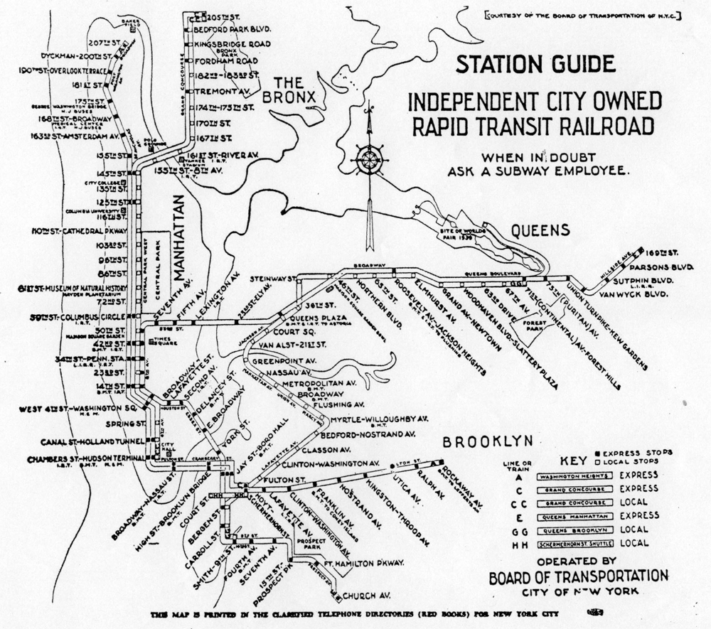
Before the Independent Subway (IND) there were two transit companies that ran the subways in NYC; the Interborough Rapid Transit Co (IRT) and the Brooklyn-Manhattan Rapid Transit Co (BMT). The MTA (Metropolitan Transportation Authority) phased out these names long ago but old timers still call each line by their original names: The IRT Lexington Ave Line (4,5,6), the IRT 7th Ave Line (1,2,3) and the IRT Flushing Line (7), the BMT Broadway Line (N,Q,R,W), the BMT Canarsie Line (L), the BMT Jamaica Line (J,Z), and the BMT West End, Seabeach and Brighton Beach Lines, among others.
These dueling systems (one had to pay extra to transfer to a different company’s line) were the lifeblood of the city but were not properly serving large sections of the fast growing metropolis. The citizens had a love/hate relationship with the companies and after years of overcrowding the city decided to step in and fund their own, independently run subway system, the Independent (IND).
The IND today is best known as the 8th Ave Line (A,C,E), the 6th Ave Line (B,D,F,V), the Fulton St Line (Brooklyn A,C), the South Brooklyn or Culver Line (F), the Queens Blvd Line (E,F,R,V), and the Crosstown Line (G). Two subways proposed originally in 1922 but never built were a line from Bay Ridge to Staten Island and an extension of the BMT Broadway Line from 7th Ave/59th St to Harlem (both will be discussed here).
From NYC Subway:
John F. Hylan was Mayor for two terms from 1918 to 1925. Legend has it that, as a young locomotive engineer for the Brooklyn Rapid Transit Company (BRT, predecessor to the BMT), he was fired because he exceeded the posted speed operating his train around a curve. He was studying for the bar exam while employed at the BRT. Once he was mayor, he was in a position of power to get even. He regularly made it difficult for the IRT and BRT to expand their lines or obtain funding (the 5 cent fare was a losing proposition and could not be changed without city approval). To get even with the private operators, he wanted a subway run by the city “independent of the traction interests”. In fact, many of the lines the Independent opened were in direct competition with existing lines of the time, and those existing lines ended up being torn down in favor of the Independent lines.
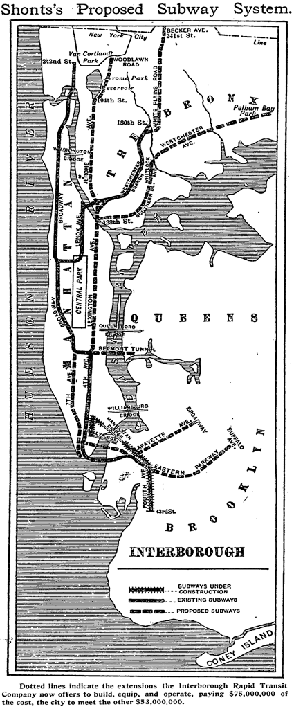
The IND was an instant hit and even inspired the Billy Strayhorn/Duke Ellington hit “Take the A Train”. First proposed in 1922 and opened beginning in 1932, the IND was a modern marvel in terms of planning and design; the stations were larger and were built with express and local stops designed to eliminate the bottlenecks that older express stations had created. While it would be decades until the original IND system was complete, the city early on saw the new system as a huge success and immediately began planning a second system that would reach areas of the city still unserved by the current subways. This plan was known as the IND Second System.
Manhattan
Second Ave Trunk Line
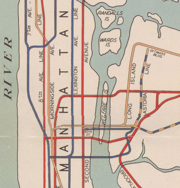
The most famous, or infamous, part of the Second System was a 4 to 6 track trunk subway running from the Harlem River to Pine St in downtown. It may seem obvious for the need for a second subway line through the east side of Manhattan today but at the time there were actually 3 lines, the Lexington Ave subway and two elevated trains running up 3rd and 2nd Aves. The reason that the Second Ave subway was put off for so long was because the east side was already well served until the 1940s and 1950s when the elevated lines were torn down.
Because plans for the Second Ave line have been around for so long they have been subject to the most change. Originally the line was to be a 2 track subway from Downtown until Houston St where a second set of tracks joined until 61st St where a planned connection to the 6th Ave line was to come in on another set of tracks, bringing the total tracks through to Harlem to 6. Here the line would continue on to the Bronx as 4 tracks. The idea was for a super-express line that would connect to the 6th Ave line. It is interesting to note that in the original plans there were no connections from Queens. I will cover more of this in my post about the Second Ave Subway (coming soon).
Two connections that were planned as part of the Second Ave subway were the 61st St line (mentioned above) and a spur at Houston St that would connect with the 6th Ave line as it headed into Williamsburg (to be explained below). Updated proposals for the next 30 years moved this tunnel further north with a connection to Queens and was eventually the only major section constructed. The 61st St tunnel proposal eventually morphed into the 63rd St tunnel which connects the F line to Queens, opened in 2001. When this tunnel was built there were provisions made to connect the 63rd St tunnel to a future Second Ave subway and to connect the Second Ave subway to the tunnel to Queens.
Morningside Ave Line
Details on this are sketchy but it seems that plans for a line branching off the BMT Broadway Line at 57th St to run into Harlem were proposed even back when the Broadway Line was under construction. In early BMT maps there is shown a small stub past 57th St which represented the actual stub end of the express tracks terminating past the station. The plans called for a 2 track tunnel to run north under Central Park (the park, not Central Park West) and then swing west somewhere in the West 80s. From here the line would head north under, presumably, Columbus Ave and into Morningside Park along Morningside Ave. From here the line would presumably run north along Convent Ave until terminating at 155th St. What is peculiar is that plans for this line were included in the original IND system, dropped in the 1929 plan, but then added again in the 1939 plan.The stub end tracks at 57th St were eventually rerouted so they now link up with the 63rd St tunnel (F) as so to allow Broadway trains to run on the Second Ave line when constructed. More about this in my upcoming Second Ave Subway post.
South 4th and Utica Ave Line
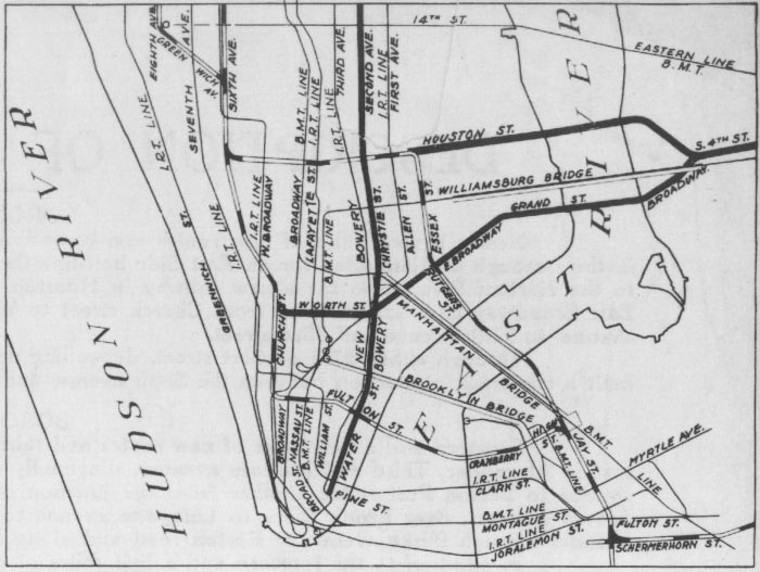
One of the most impressive proposals from the Second System was for a massive 4 to 8 track subway line through Williamsburg with two 4 track spurs branching out into unserved parts of Brooklyn and Queens. The first part of the line was the Utica Ave line which branched off from the 6th Ave line in Manhattan at 2nd Ave and traveled along East Houston and under the East River to Grand Ave in Williamsburg. South of this was the Rockaway Line which branched off the 8th Ave line in Manhattan and swung east under Worth Ave and along East Broadway, under the East River and under Broadway in Williamsburg. These two lines then met up under South 4th St and traveled to Union Ave in an, at one point 4 track and then expanded to 6 track, trunk line. These lines then connected to the Crosstown Line (G) in a massive 4 platform station which was actually built and remains abandoned under the streets of Williamsburg! (Click here for more information)
From here 8 tracks were planned to run under a new street parallel to Broadway to Beaver St, Bushwick Ave and Myrtle Ave. At Myrtle Ave the two lines branched off in two, 4 track lines; the Utica Ave line tunning south along Utica Ave through Bedford-Stuyvesant, Crown Heights, and East Flatbush, and the Rockaway line traveling east under Myrtle and Central Aves through Glendale, turning south after Woodhaven Blvd along the LIRR right-of-way to connect to the Rockaways. The Utica Ave line, when it reached Ave S in Flatbush, turned west to connect with an extension of the IRT Flatbush Line (2,5) under Nostrand Ave and together these lines ran to Voorhese Ave in Sheepshead Bay. At one point an additonal tunnel was proposed to branch off here and travel to Queens under Flushing Ave.
Later plans also included a connection to the Williamsburg Bridge to replace the BMT Jamaica Line (J,M,Z) and added a subway from the Myrtle Ave junction along Bushwick Ave to Broadway Junction. Additional plans included a subway branching off the Crosstown Line (G) under Lafayette Ave which would connect to the Rockaway Line under Myrtle Ave.
As mentioned, a shell station was actually constructed at the Broadway stop on the Crosstown Line (G). A partial shell station was also constructed at the Utica Ave station on the IND Fulton Ave line (A,C) to service connections to the Utica Ave line. Eventually a subway connection was created to the Rockaways but instead of running into Queens it was truncated back to the Fulton Ave (A,C) line in Ozone Park.
The Bronx
The Bronx was and still is one of the better served areas of the city in terms of subways but the eastern portion, which at that time had not developed as fast as the western Bronx, was still under served. To address this the Second System proposed a 4 track trunk line into the eastern Bronx. Continuing from the Second Ave subway at the Harlem River, a 4 track subway would have snaked its way north under Alexander Ave and Melrose Ave to 163rd St where the line would split. One branch would head due east under 163rd St to Unionport where it would run under Lafayette Ave to East Tremont St in Throggs Neck.
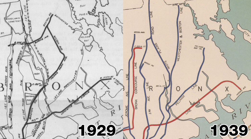
The other branch would run north under Boston Post Road to the IRT yards at 180th St. Here the line would run east under Morris Park Ave until about Seminole Ave where it would turn north and run under Wilson Ave to Boston Post Road, turning east to finally terminate at Baychester Ave. However right before the line turned onto Boston Post Road it would connect with an extension of the Concourse Line (B,D) which was to be extended from its terminal at 205th St under Burke Ave to Boston Post Road.
If you look at the map of the subway today it would seem peculiar to extend the subway into an area that is already covered by the IRT Dyre Ave line (5). What you don’t realize is that the Dyre Ave line (5) wasn’t part of the subway at all at that point and was actually a section of the New York, Westchester, and Boston Railroad. This right-of-way was “captured” by the city after the railroad went bankrupt in 1935. Because of this addition the plans for a subway through this area were dropped and are not found on the updated 1939 map.
Northern Queens
Keep in mind that most of Queens was developed after World War 2. This means that even before the IND had built its first line Queens was only served by two subway lines, a few commuter railroads, and a number of streetcar lines (as opposed to the innumerable lines that served Manhattan and Brooklyn). The only lines the original IND built were the Queens Boulevard line (E,F,G,R,V) and its extension down Hillside Ave (F), and these stuck close to the LIRR ROW which was already developed. So knowing that Queens was the next place where development was going to occur, the IND proposed extending already built lines out into northern Queens.
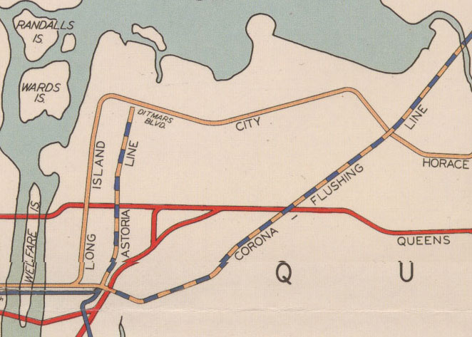
The two subways already there were jointly operated by the IRT and the BMT per agreement in the Dual Contracts (the two contracts the city gave to these competing transit companies in 1913 to stop them from building redundant and competing subways.) The Astoria line (N,W) and the Corona (7), todays Flushing line went through some pretty barren territory but by the 1920s people were streaming out the packed tenement districts into new garden apartments and single family homes in Queens. The IND Second System, which at this point had no control over these two companies, proposed extending both lines further out into northern Queens.
The Astoria line, which terminated (and still does) at Ditmars Blvd, would have been extended down Ditmars Blvd to Astoria Blvd where it was go from 2 to 4 tracks. It would run down Astoria Blvd through East Corona, elevated, to 112th St where it would turn south and then east across the Flushing River. At this point Flushing Meadow Park was nothing more than a marsh and dumping ground (Robert Moses built the park for the 1939 Worlds Fair). From here it would travel along Horace Harding Blvd, which today is the Long Island Expressway, to Nassau Blvd, today’s Francis Lewis Blvd. Later these plans were altered so that instead of extending the elevated line, a new subway would run from Queensboro Plaza under 21st St in Long Island City, then following this same path as a subway but continuing under Horace Harding Blvd to Marathon Parkway.
The other line, the Corona line, originally terminated at 111th St but had been extended to Flushing/Main St. In the Second System plan it was to be continued parallel to the LIRR Port Washington commuter rail branch out to Bayside, 221st St. Before that, at 149th St, a branch north to Whitestone and College Point was planned. There had at one point been a steam railroad that branched off from the Port Washington track before Flushing and traveled north to College Point and east to Whitestone. The city had debated buying the line after trains were discontinued but in the end nothing came of it. The proposed right-of way would have served more people as it traveled through level ground rather than wetlands. These plans were kept in updated plans but the area soon developed without the expanded subways.
Jamaica and Flushing
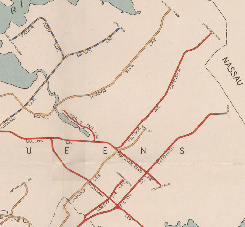
The first IND system terminated its only Queens line in Jamaica which, like Flushing, was once a separate town until Queens County was consolidated into greater New York City in 1898. Jamaica had a long history of development with improved transportation as the first railroad in the city connected it to Brooklyn in 1834. Because the city knew that the farms surrounding Jamaica would soon turn into housing the IND built the Queens Blvd line with the expectation that it would be extended in the future. The Hillside Ave branch is 4 tracks until it terminates at 179th St, unusual until you understand that the subway was intended to be extended out to Little Neck Road. There was also a set of tracks that dead-ended before Hillside Ave, originally these were intended for a subway south under Van Wyck Blvd to Rockaway Blvd. These plans were kept even with the building of Idlewild (JFK) Airport but were not shelved until Robert Moses built the Van Wyck Expressway down the same right-of-way and, ignoring the pleas from city planners, intentionally left no room for a subway along the median of the highway (Chicago had done this successfully with a subway extension out to O’Hare Airport). These extra tracks were eventually used when the MTA built the Archer Ave subway to replace the elevated tracks through Jamaica Center.
Southern Jamaica was sparsely settled but growing quickly at this time. The only section served by rapid transit up until then was the end of the Liberty Ave elevated line which ran through Ozone Park to 119th St. The IND, which had built its Fulton Ave subway (A,C) in direct competition to the elevated Fulton Ave and Liberty Ave lines, was keen on “capturing” the Liberty Ave elevated line and incorporating it into the Fulton Ave subway (which it did). The Second System then planned to extend the line, elevated, down Liberty Ave to Sutphin Blvd where it would snake its way south and then east along 110th Ave to 180th St. Here the line would split, with one branch running along the LIRR right-of-way north and then doubling-back west to terminate at the Jamaica Center LIRR station, while the other branch continued east along Brinkerhoff Ave to Hollis Blvd, finally terminating at Springfield Blvd. This was a rather serpentine route and the plans were eventually altered so that the extension of the Fulton St subway would run east under Linden Blvd to 229th St instead.
Central Queens
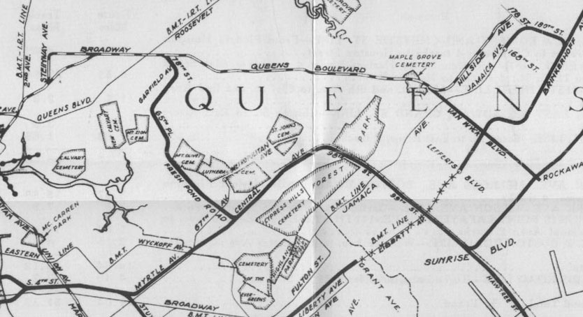
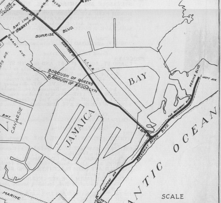
The subway known as the Winfield Spur is one of the more peculiar instances of transit planning in New York City. It is peculiar for two reasons, the first being its serpentine, meandering path through central Queens, and the second is that an actual station complete with tile tile work was constructed for the line. The concept was to kill two birds with one stone; to provide subway service to areas of central Queens such as Maspeth, Middle Village, and Glendale while also connecting the Rockaways to downtown and midtown via subway service. The area of central Queens through which the line was to run is home to many large cemeteries and because of this planners had to route the line around the cemeteries while trying to service the most number of people.
From NYCSubway.org:
It would have been a two track line arising from the Roosevelt Avenue station (the never-used upper level station, but also would have track connections to the main line), and curving southeasterly between 78th and 79th Sts. to Queens Blvd., then along the LIRR ROW into Garfield Avenue to 65th Place, then along 65th Place to Fresh Pond Road, and then along Fresh Pond Rd and Cypress Hills Avenue to a connection with the Central Avenue line outlined above. The line would be 2 tracks, and would be subway to 45th Avenue, then elevated to Fresh Pond Road, then subway again to Central Avenue. In looking at the map, the rationale for the circuitous route becomes a little more apparent, since it appears to skirt some large cemeteries, thus staying in the residential/commercial areas.
Note the part about the never-used upper level station. At Roosevelt Ave on the Queens Blvd line there is a part of the station that is out of reach to regular people that is actually a single platform station for trains to terminate from the Rockaways. Additional tracks would have connected the line to the Queens Blvd line. Work on these extra tracks was completed up to 78th St and land that was taken for construction of the line was eventually turned into Frank O’Connor playground.
After connecting up with the proposed Rockaways subway under Central Ave, the line would turn south past Woodhaven Blvd along the LIRR right-of-way. Tracks would continue to the Rockaways so that passengers could go downtown via South 4th St in Williamsburg or into midtown via the Winfield Spur. At 120th St in South Ozone Park, 2 tracks would branch east to serve southern Jamaica and Cambria Heights. The line would have cut a new road though a sparsely settled area to Linden Blvd but would have meant that now southeastern Queens had evenly spaced subway service to downtown and midtown.
Sometime in the 1930s it was decided that the Winfield Spur was just about too ridiculous and a better connection was drawn up which would branch off the Queens Blvd line after 63rd St rather than Roosevelt Ave. The branch would head due south until it reached the LIRR junction at Rego Park. Here it would continue on to the Rockaways using the same LIRR Rockaways right-of-way. Plans for the 120th St subway were dropped at this point.
Staten Island
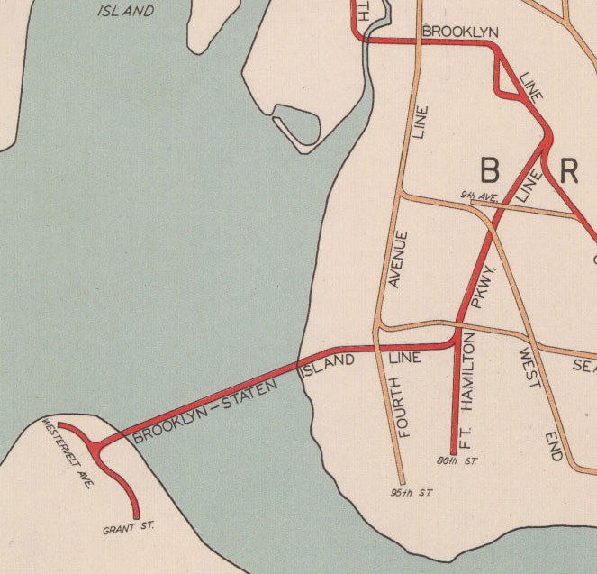
The South Brooklyn line (F,G) of the first IND system ended short after weaving its way through South Brooklyn, Park Slope, and Windsor Terrace. The line is built with 4 tracks so presumably it was expected to be extended southernly. Since it was built right up to the BMT Culver Line it was no surprise that the IND “captured” the elevated line and combined the two. But the elevated Culver line is only 3 tracks while the IND South Brooklyn is 4. This leaves the room for another branch and in the Second System the IND decided to reach out to the only borough not serviced by a subway, Staten Island.
The Ft Hamilton/Staten Island line would have branched off from the South Brooklyn line after the Ft Hamilton Parkway stop and continue in a 4 track tunnel to Bay Ridge Ave where one branch would continue south to 86th St and the other would head west under Bay Ridge Ave, under New York harbor, to St George on Staten Island. Here the line would split and some trains would head north along the Staten Island Railroad North Shore Branch while the other would head south along the main line. The plans for this connection were not in the 1929 plan, though a proposed vehicular tunnel was present, but added in the 1939 plan. In fact plans for a train/vehicular tunnel had been proposed as far back as at least 1910! I wish I knew more about what happened to the plans for these lines as it was 30 years later that Robert Moses finally did built a connection between Staten Island and Brooklyn via the Verrazano-Narrows bridge. But true to form he left no room for rapid transit.
Conclusion
The purpose of this post was to give some context and prep your mind for the proposals to come. Much has been written about the IND Second System and I was elated when I first discovered the plans. I have to give thanks where they are due and most of my information came from these sources:
- Proposed New York City Subway expansion (1929–1940)
- IND Second System – 1929 Plan, NYCSubway.org
- Subway Expansion in Williamsburg, Waterfront Preservation Alliance
- Dreaming of the Second System, Second Ave Sagas
- Abandoned Stations, by Joseph Brennan
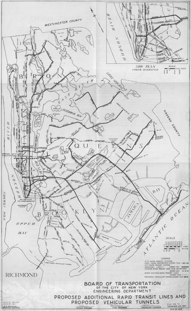
Also, for you maps lovers out there, you can see the full versions of the 1929 and 1939 plans below. The super-big versions of these maps are located here.

The futureNYCSubway
- IND Second System
- Post War Expansion
- The Second Ave Subway: History
- The Second Ave Subway: To The Bronx and the Nassau Line
- Brooklyn: Bushwick Trunk Line
- Manhattan: West Side and Hudson Crossings
- Queens: Flushing Trunk Line
- Staten Island: The Last Frontier
- TriboroRX and Atlantic Ave Super-Express
- Conclusion: the vanshnookenraggen plan
Buddy, you’ve done your homework very well.
I been reading this article for about an hour, and I can say, you’re done a lot of research on IND Second System. Your post is very well explained.
Keep up the good work, and let me be the first to say congratulation.
Good luck
There are several errors in the IND Second System description.
The Myrtle Central Avenue subway was design to serve the Rockaways as a seperate right a way from the LIRR Rockaway line, which has a similar pattern but this subway would have provide a better service than today’s Rockaway line because it includes a cross connection with the Queens Blvd line (using the Winfield spur) is outline as planned with an additional line serving parts of southeast of Queens by following along 120th Avenue to Springfield Blvd. This additional line would have come off the new Rockaway line near N. Conduct Avenue if you look at the map closely.
The 61st Street Subway was design to connect with the second avenue subway since no Queens connection is outline as planned in the 1929 plan.
The 63rd Street subway was mention several times but was not put into plans and construction up until 1968. This is differ from the 61st Street subway as this was designed to have four tracks: a bi level of two, where one pair comes from the Broadway line to connect with the second avenue subway as another pair comes from the sixth avenue line to emerge with the Queens Blvd line. These are seperate connections but they can be use if the junction is well planned out to handle the capacity.
The 76th Street tunnel was design to come off the Sixth Avenue line and feed the local tracks of the Queens Blvd Line between Steinway Street and 46th Street and would be serve by a local train, while the 53rd street line becomes the express and the 63rd handles both local and express.
As for the Fort Hamilton Subway, someone came up with this idea but it has nothing to do with merging the tracks onto SIR as it wouldn’t provide as much service
other than that, everything else you explain was actually good but I think you might want to try to find the history of the IND at http://www.nycsubway.org. You can also find the second avenue suway timelime and the changes of the south fourth street line. These two documents have these plans as well as the other ones not explain anywhere else
Id Say That the plan for a EXTENSION Of The (7) In Queens Will Have A Big Impact On Bus Transferrs At Main Street And The Streets Will Be Less Crowded With Buses (I Guess)