


This is something I’ve been wanting to do for a long time but didn’t know how to start. I present my Google Maps version of the proposed Lower Manhattan Expressway and Mid Manhattan Expressways. (I didn’t know how to draw maps to look like Google Maps but it’s pretty easy.) Now there have been maps showing these proposed highways before (they are included in my Unbuilt Highways Map of NYC) but the point of doing it up to look like a Google Map was to put these highways in a modern context (also I’m sure there are plenty of people who didn’t even know about these). We have become so accustomed to viewing the world through Google Maps (or some other online mapping software) that I feel like these maps are starting to shape our view point of the city.
A map, after all, is a representation of reality with certain things omitted (or in this case, added). As mapping software becomes even more ubiquitous now that they are in the palm of our hands (Blackberrys, iPhones, etc), I think it will become all too easy for people to just accept what they see as reality. This is a dangerous prospect but one I think can be taken advantage of when trying to communicate certain information, such as what a neighborhood you know pretty well would look like with an elevated highway slammed through it. This was true for me, at least, while I was making these; Hand erasing buildings through SoHo, TriBeCa, and the LES was an eery experience as I tried to imagine what these places would really look like if my brush was a bulldozer.
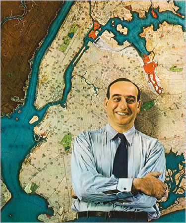
And thus I began to understand the failing of Robert Moses (well, this one anyway). He didn’t drive and lord knows he didn’t think much of these areas which he tossed off as “slums”. Â There is a famous image of a young Moses standing in front of a map of the entire city (to the left).
What you need to be aware of when you are looking at a map is how it lies to you; it is a seductress. You think because it represents reality you can better understand reality, which is true only to a point. But when combined with the power and ambition of Robert Moses the maps seduction warped him and let him think that a line across the map represented far less chaos and destruction than he perceived. Adjusting lines on a map is easy and because a map is a visual design adjusting lines seems like a good way to clean up the map. But the lines on a map hide the fact that they represent something real, a street that needs to be moved, houses that need to be knocked down, families and businesses that need to be kicked out. I’m not saying that Moses wasn’t aware of these things, in fact he was keenly aware. But it was so easy and sexy to clean up the map that he was willing to do whatever it took to draw his maps to be permanent.